Eastern Mojave Vegetation
Tom Schweich
|
Eastern Mojave Vegetation
| 12th Street, Golden, Jefferson County, Colorado |
|
Tom Schweich |

|
East-west on south side of Clear Creek. |
|
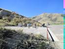
Locations: White Ash Mine. |
End of street at Stermole Track and Field Complex. This appears to be the location of the White Ash Mine. |
| The end of 12th Street also seems to be named Birch Street | |
|
Other articles:
|
Memorial and Interpetive Plaque for White Ash Mine. This is also Stop 7 on the Mines Geology Trail. |
| Brooks Field Stadium | |
| Dirt road to CSM | |
|
Other articles:
|
Intersection: Maple Street |
|
Other articles:
|
Intersection: Illinois Street |
|
Other articles:
|
Intersection: Cheyenne Street |
|
Other articles:
|
Intersection: Arapahoe Street |
| Intersection: Miners Alley | |
|
Other articles:
|
Intersection: Washington Avenue |
| Intersection: Prospectors Alley | |
|
Other articles:
|
Intersection: Jackson Street |
|
Other articles:
|
Intersection: Ford Street |
|
|
Coors Brewery |
| If you have a question or a comment you may write to me at: tas4@schweich.com I sometimes post interesting questions in my FAQ, but I never disclose your full name or address. |
Date and time this article was prepared: 4/14/2024 5:28:07 PM |