|
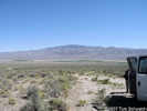
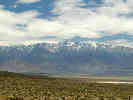
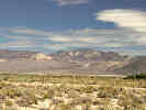
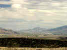
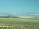
Fish Lake Valley is a 2,600 km2 basin about 70 km east of the Long Valley Caldera. Elevations of the valley floow decrease to the north from about 1,585 to 1,435 m. The valley lies between thye glaciated White Mountains on the west and the lower, unglaciated Silver Peak Range on the east. Drainage from the valley is partly blocked on the north by the low Volcanic Hills, but the playa in the northeast corner overflows intermittently northward through "The Gap" into Columbus Salt Marsh. Fish Lake Valley owes its existence to the right-oblique faulting along the Fish Lake Valley fault zone, which forms the northern end of the Death Valley - Furnace Creek fault system.
Articles that refer to this location:
Literature Referring To This Location:
-
Frankel, Kurt L., et al. 2008.
Active tectonics of the eastern California Shear Zone.
pp. in Duebendorfer, E.M., and Smith, E.I., eds.,.
Field Guide to Plutons, Volcanoes, Faults, Reefs, Dinosaurs, and Possible Glaciation in Selected Areas of Arizona, California, and Nevada.
Geological Society of America Field Guide 11.
Boulder, CO: Geological Society of America, 2008.
{TAS-pdf}
-
Haller, J. Robert, Wayne R. Ferren, Jr., Ragan M. Callaway, Dennis C. Odion, and Frank W. Davis. 1992.
A Phytogeographic Comparison of the Vascular Flora of the Wetlands of Fish Slough with the Floras of Neighboring Desert Basins.
pp. 211-222 in Hall, Jr., Clarence A, Victoria Doyle-Jones, and Barbara Widawski.
White Mountain Research Station Symposium Volume 4.
The History of water: Eastern Sierra Nevada, Owens Valley, White-Inyo mountains.
White Mountain Research Station: University of California, 1992.
{TAS-pdf}
ISBN-10: 1879851040
-
Reheis, Marith C., and Timothy H. Dixon. 1996.
Kinematics of the Eastern California shear zone: Evidence for slip transfer from Owens and Saline Valley fault zones to Fish Lake Valley fault zone.
Geology.
24(6):339-342.
-
Reheis, Marith C., and Thomas L. Sawyer. 1997.
Late Cenozoic history and slip rates of the Fish Lake Valley, Emigrant Peak, and Deep Springs fault zones, Nevada and California.
Geological Society of America Bulletin.
109(3):280-299.
{TAS-pdf}
-
Reheis, Marith C., Janet L Slate, Andrei M. Sarna-Wojcicki, and Charles E. Meyer. 1993.
A late Pliocene to middle Pleistocene pluvial lake in Fish Lake Valley, Nevada and California.
Geological Society of America Bulletin.
105: 953-967.
{TAS-pdf}
-
Robinson, Paul T., Edwin H. McKee, and Richard J. Moiola. 1968.
Cenozoic Volcanism and Sedimentation, Silver Peak Region, Western Nevada and Adjacent California.
pp. 577-611 in Coats, Robert R., Richard L. Hay, and Charles A. Anderson.
Studies in Volcanology: A Memoir in Honor of Howel Williams.
Memoir 116.
Boulder, Colorado: Geological Society of America, 1968.
{TAS}
-
Stockli, Daniel F., Trevor A. Dumitru, Michael O. McWilliams, and Kenneth A. Farley. 2003.
Cenozoic tectonic evolution of the White Mountains, California and Nevada.
GSA Bulletin.
115(7):788-816.
{TAS-pdf}
|
|
If you have a question or a comment you may write to me at:
tas4@schweich.com
I sometimes post interesting questions in my FAQ, but I never disclose your full name or address.
|
A, B, C,
D, E, F,
G, H, I,
J, K, L,
M,
N, O,
P, Q, R,
S, T, U,
V, W, X,
Y, Z
[Home Page] [Site Map]
Date and time this article was prepared:11:12:31 AM, 5/10/2024.
|
 Eastern Mojave Vegetation