Eastern Mojave Vegetation
Tom Schweich
|
Eastern Mojave Vegetation
| County Route G14 |
|
Tom Schweich |

|
(No Preface) | ||
|
Other articles:
|
Junction: US Highway 101, north through the Salinas Valley, or south through King City to San Luis Obispo and Los Angeles. | ||
| Junction: Oasis Road | |||
| Junction: San Lucas Road | |||
| Pass, 1,514 feet. | |||
| Fort Hunter-Liggett border. | |||
| Junction: Sulphur Springs Road | |||
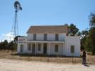
 Dutton Hotel at Jolon Dutton Hotel at Jolon
|
Dutton Hotel | ||
| Junction: Lockwood-Jolon Road. | |||
|
Other articles:
Locations:
Jolon.
|
JolonJunction: Mission Road, west into Fort Hunter Liggett and Mission San Antonio de Padua. | ||
| Fort Hunter-Liggett border. | |||
| Martinus Corner. Junction: Jolon-Pleyto Road, Cross Road | |||
|
Other articles:
|
Junction: Lockwood-Jolon Road, County Route 18 County Route G-14 turns south at this intersection, winding its way past San Antonio and Nacimiento Reservoirs en route to Paso Robles. County Route G-18 is a more direct route to US Highway 101 near Bradley. | ||
| Junction: Jolon-Pleyto Road. | |||
| San Antonio River. | |||
| Junction: San Antonio Road. | |||
|
Monterey County above San Luis Obispo County below | |||
| Junction: Interlake Road. | |||
| Nacimiento Dam | |||
| Junction: Chimney Rock Road, also to Adelaida and beyond. | |||
| Junction: San Marcos Road. | |||
|
Other articles:
|
Junction: Adelaida Rd., to Adelaida. | ||
|
Other articles:
Locations:
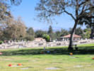
Paso Robles District Cemetery.
|
Paso Robles District Cemetery | ||
|
Other articles:
|
Junction: Spring Street as 24th Avenue | ||
|
Other articles:
|
Junction:
|