
|
Unknown Road giving access to quarry in southern portion of Harvard Hill.
|
|
Other articles:
• Field Notes:
23 Apr 2010;
23 Apr 2010;
23 Apr 2010;
Locations:
Harvard Hill.
 Structure of south Harvard Hill Structure of south Harvard Hill
|
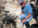
David Miller shows the location of the thrust fault. |
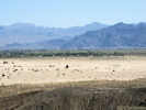
View south across Mojave River from Harvard Hill. |
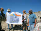
STOP M - 1. South Harvard Hill stratigraphy and structure. Walk south to the contact between silicified limestone forming a high ridge and the sands that lie to the southwest of that ridge, then proceed upsection across the ridge, across another ridge and to the dark hill on the northeast. We will discuss the basal thrust fault that places Miocene limestone of the Barstow Formation over Pleistocene deposits of Lake Manix, the stratigraphic sequence above the limestone and its significance, and a higher thrust fault and overlying lake sediments, tuff, and rock-avalanche breccia.
|
|
Other articles:
• Unknown Road:
at unk rd;
|
Junction: Unknown Rd, around the west side of Harvard Hill.
|
|
Other articles:
• Manix Road:
at unk rd;
|
Junction: Manix Road
|
|
If you have a question or a comment you may write to me at:
tomas@schweich.com
I sometimes post interesting questions in my FAQ, but I never disclose your full name or address.
|
[Home Page] [Site Map]
Date and time this article was prepared:
4/21/2025 8:16:19 PM
|
 Eastern Mojave Vegetation