Eastern Mojave Vegetation
|
Eastern Mojave Vegetation
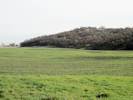
| Miller's Field paleoseismic site, Monterey County, California. |
|
Gazetteer Query: See also: Water Tank paleoseismic site.
|
||
|
Investigation of a right-laterally offset channel at the Miller’s Field paleoseismic site yields a late Holocene slip rate of 26.2 +6.4/-
4.3 mm/yr (1s) for the main trace of the San Andreas fault at Parkfield, California. This is the first well-documented geologic slip rate
between the Carrizo and creeping sections of the San Andreas fault. This rate is lower than Holocene measurements along the Carrizo
Plain and rates implied by far-field geodetic measurements (~35 mm/yr). However, the rate is consistent with historical slip rates, measured to the northwest, along the creeping section of the San Andreas fault (<30 mm/yr). Together, this slip rate suggests that significant slip is accommodated by structures in a zone beyond the main San Andreas fault trace.
Articles that refer to this location:
Literature Referring To This Location:
| ||
| No collections made at this location. | ||
| If you have a question or a comment you may write to me at: tomas@schweich.com I sometimes post interesting questions in my FAQ, but I never disclose your full name or address. |
A, B, C,
D, E, F,
G, H, I,
J, K, L,
M, Date and time this article was prepared:8:31:57 PM, 4/21/2025. | |