Eastern Mojave Vegetation
|
Eastern Mojave Vegetation
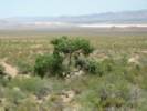
| Ivanpah (#1), San Bernardino County, California. |
|
Gazetteer Query: See also: Ivanpah Springs.
|
||
|
Ivanpah was the first mining town, perhaps the first settlement , in the Mojave Desert. In August 1871, this location had 15 buildings, including a hotel, two stores, an office and headquarters of the Piute Company, and small shake-covered adobe houses "on the average larger than would be expected in so young a place." In 1880 and 1881, gold and silver strikes at Oro Grande, Providence, and Calico began drawing away many miners. The post office closed in April, 1899. In 1903, Ivanpah's name was given to a point on the California Eastern Railway out in Ivanpah Valley (generally called Ivanpah #2 now), and still later given to a point on the Union Pacific at the crossing with Ivanpah Road (sometimes also called Ivanpah #3). Today, the GNIS lists the original site of Ivanpah as Ivanpah Springs.
Latitude: 35.5405369 Longitude: -115.5291645 (° decimal)
Articles that refer to this location:
Literature Referring To This Location:
| ||
| No collections made at this location. | ||
| If you have a question or a comment you may write to me at: tomas@schweich.com I sometimes post interesting questions in my FAQ, but I never disclose your full name or address. |
A, B, C,
D, E, F,
G, H, I,
J, K, L,
M, Date and time this article was prepared:2:36:18 PM, 1/5/2025. | |