 Eastern Mojave Vegetation
Edited by Tom Schweich
|
Eastern Mojave Vegetation
| Oregon Highway 104 "Fort Stevens Highway," Clatsop County, Oregon. |
|
Edited by Tom Schweich |

|
The southern terminus of OR 104 is at a junction with US 101 near south of Warrenton. It heads due north for 6 miles (9.7 km), ending at the entrance to Fort Stevens State Park near Hammond. The southern portion of the route, and its spur constitute an old portion of US 101. |
| Fort Stevens | |
|
Other articles:
|
Junction: Ridge Road |
|
|
Hammond |
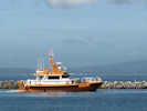 Pilot leaves Hammond harbor, Oregon. Pilot leaves Hammond harbor, Oregon.
|
Junction: Iredale Street Access to Hammond Harbor, and a place to eat lunch. While we were eating ours, this bar pilot departed. Hammond is downriver from Astoria, and transfers bar pilots to and from the big ships as far as 10 to 15 miles out in the ocean during stormy weather or calm. The bar of the Columbia River is one of the most treacherous river bars in the world, and some call it the most treacherous. Piloting the ships across the bar is a specialty occupation, and the pilots have to understand not only the tides, currents, weather, and what lies below the water line at any given level of the tide, but also the capability, draft, and size, of each ship they board. |
| Junction: NW 11th Street | |
|
|
WarrentonJunction: East Harbor Street, to US Highway 101, and Astoria. |
| Junction: Alt. US Hwy 101, "Fort Stevens Highway Spur" | |
| Junction: Delaura Beach Lane | |
|
Other articles:
|
Junction: Columbia Beach Road to Ridge Road. |
|
Other articles:
|
Junction: US Highway 101 |
| If you have a question or a comment you may write to me at: tomas@schweich.com I sometimes post interesting questions in my FAQ, but I never disclose your full name or address. |
Date and time this article was prepared: 5/12/2025 2:58:07 PM |