Eastern Mojave Vegetation
Edited by Tom Schweich
|
Eastern Mojave Vegetation
| US Highway 163, Arizona and Utah. |
|
Edited by Tom Schweich |

|
From near Bluff, Utah, west and southwest through Monument Valley to just past Kayenta, Arizona. | ||||||
|
Other articles:
|
Junction: US Highway 191, 4 miles west of Bluff, Utah. | ||||||
| Cross Comb Ridge | |||||||
| Cross Comb Wash | |||||||
|
Literature Cited:
Locations: Snake Canyon. |
Cross Snake Canyon Near this location is a paleosol collection site in the Permian Cedar Mesa Formation used by Retallack in his 2009 study of greenhouse crises of the past 300 million years. Retallack used stomatal index data for fossil Ginko and related leaves as a proxy for past CO2 spikes and paleosol chemical data as proxies for temperature and humidity changes. These data show that global warming due to CO2 rise is a not a unique event in earth history and that the magnitude of the coming anthropogenic greenhouse pales in comparison with past greenhouse spikes at times of global mass extinctions. | ||||||
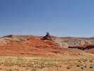
| Lime Ridge | |||||||
| Junction: Valley of the Gods Road | |||||||
|
Locations: Valley of the Gods. |
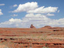
Valley of the Gods | ||||||
|
Other articles:
|
Junction: Utah Highway 261 | ||||||
|
Other articles:
Locations:
Mexican Hat Rock.
|
Mexican Hat Rock | ||||||
|
Other articles:
|
|||||||
|
Locations: Mexican Hat. |
Mexican Hat | ||||||
|
Other articles:
Locations:
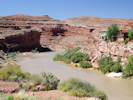
San Juan River.
|
Cross the San Juan River. | ||||||
|
Other articles:
|
|||||||
| Junction: Monument Valley Road | |||||||
|
Locations: Goulding. Monument Valley Navajo Tribal Park. |
Junction: Monument Valley Road, Oljeto Road Take Monument Valley Road to the southeast to the Monument Valley Navajo Tribal Park Visitor Center. Take Oljeto Road west to Gouldings, Utah. | ||||||
|
Other articles:
|
San Juan County, Utah above
Navajo County, Arizona below | ||||||
|
Literature Cited:
Other articles:
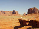
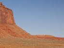
Locations: Monument Valley. |
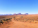
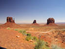
Monument Valley
The floor of the valley and lower slopes of the buttes and mesas are comprised of red and reddish brown sandstones and siltsones of the Permian Organ Rock Formation, deposited by dryland fluvial systems, low-relief aeolian sand sheets and other erg-margin depositional systems. The vertical cliff faces are aeolian erg deposits of the Permian DeChelley Sandstone. The Lower Triassic Moenkopi (Hoskinni Member) and Upper Triassic Chinle Formation (Shinarump Member) comprise the thinner-bedded units that cap some of the mesas (Demko, 2003). | ||||||
|
|
Kayenta | ||||||
|
Other articles:
|
Junction: US Highway 160 | ||||||
| If you have a question or a comment you may write to me at: tomas@schweich.com I sometimes post interesting questions in my FAQ, but I never disclose your full name or address. |
Date and time this article was prepared: 5/12/2025 2:58:56 PM |