Eastern Mojave Vegetation
Tom Schweich
|
Eastern Mojave Vegetation
| Utah Highway 21 |
|
Tom Schweich |

|
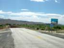
Utah Highway 21 goes from the Nevada-Utah border near Baker, Nevada through Milford and Minersville, to Beaver on Interstate 15. | |
|
Other articles:
|
Junction: NV Hwy 487, northwest past Baker and Great Basin National Park to US Highways 6 and 50. Nevada above. Utah below. | |
|
Locations:
Snake Valley.
|
||
| Junction: UT Hwy 159, north to US Highways 6 and 50. | ||
|
Other articles:
Locations:
Snake Range.
|
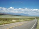
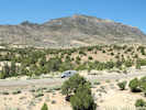
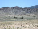
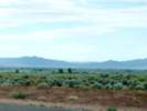
I think this photo was taken from a point just west of Halfway Summit. The low hills at the left would then be the north end of the Mountain Home Range. | |
| Mormon Gap | ||
|
Other articles:
Locations: Mountain Home Range. |
Mountain Home Range to the southwest. No Frasera albomarginata collected there, but there is an S. L. Welsh collection of F. speciosa made there. | |
|
Locations: Antelope Valley. |
Antelope Valley. Possible locality of a collection of Frasera albomarginata. | |
|
|
Halfway SummitHalfway Hills to the north | |
| Warm Cove to the north | ||
|
Other articles:
Locations: Warm Cove Ridge. |
Warm Cove Ridge to the north, on the east side of Warm Cove. There is a collection of Frasera albomarginata from a location called "Warm Point Ridge." However, I believe the correct name for the location is Warm Cove Ridge | |
|
Other articles:
Locations:
Warm Point.
|
Warm Point to the north. | |
|
Other articles:
|
||
|
Millard County
Beaver County | ||
|
Desert Range Experimental Station to the north. The Desert Range Experimental Station (DRES) is managed by the U.S. Forest Service (USFS). | ||
|
Other articles:
Locations: Pine Valley. |
Pine Valley | |
|
Other articles:
Locations: Pine Valley. |
Junction: Ferguson Desert Road, north past Crystal Peak Road, through the Ferguson Desert to US Highway 50. | |
| Sols Knoll | ||
|
Other articles:
|
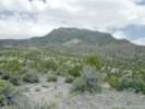
View north across Utah Highway 21 at location west of Wah Wah Summit where Frasera albomarginata was found. | |
|
Other articles:
|
Frasera albomarginata has been collected 0.7 mile west of Wah Wah Summit. | |
|
Other articles:
|
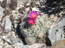
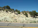
Small Mammallaria beside the road, just west of Wah Wah Summit. | |
|
Literature Cited:
Other articles:
Locations: Wah Wah Mountains. Wah Wah Summit. |
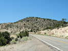
Wah Wah Summit
| |
|
Other articles:
Locations:
Wah Wah Mountains.
|
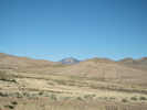
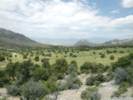
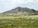
Bitterbrush, Junipers, and grassland north of the summit. | |
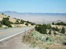
 Looking west near Wah Wah Summit. Looking west near Wah Wah Summit.
|
Looking up the hill, to the west, at the location Collection No. 548 was made. | |
|
Other articles:
|
Location of Frasera albomarginata along the highway. | |
 Looking east near Wah Wah Summit. Looking east near Wah Wah Summit.
|
Looking back down the hill, to the east, from where Collection No. 548 was made. | |
|
Other articles:
Locations:
Wah Wah Springs.
|
Wah Wah Springs to the south of the highway. There is a single collection of Frasera albomarginata from Wah Wah Springs. | |
|
|
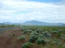
Wah Wah Valley | |
| Junction: Wah Wah Mines Road | ||
|
Literature Cited:
Other articles:
Locations: Wah Wah Mountains. Wah Wah Valley. |
| |
|
Other articles:
Locations:
Frisco.
San Francisco Mountains.
|
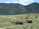
Main workings at the Frisco mine. | |
|
Other articles:
Locations:
Frisco.
|
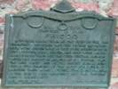
FriscoA typical mining town at the foot of the San Francisco Mountains was fed by the fabulously rich horn silver mine. By 1885 over $60,000,000 in zinc, copper, lead, silver, and gold were hauled away by mule train and the Utah Central Railroad. Water was shipped in as well as all supplies. The the mine caved and people moved away, leaving only a few families of the 4,000 population to maintain their homes, stores, school, and church. By the 1920's only memories and the shifting sands were left. Other possible names were: Horn Silver Camp and Silver Desert Camp. | |
|
Other articles:
Locations:
Frisco.
San Francisco Mountains.
|
Bee Hive ovens at Frisco | |
|
Other articles:
|
View east (downslope) to Milford and the Mineral Mountains. | |
|
Other articles:
Locations:
San Francisco Mountains.
|
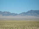
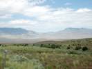
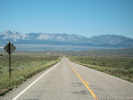
Leaving Milford westward the road climbs onto a low mesa, from which the San Francisco Mountains can be seen to the west, and the Pine Valley Mountains can be seen in the distance to the south. | |
|
Other articles:
Locations:
Pine Valley Mountains.
|
||
|
Locations: Milford. |
MilfordSince 1950, when Milford's population was at its highest number--1,673 residents--the number of residents has declined steadily--to 1,106 in 1990. Still, the community has a high school, library, Southern Baptist church, Catholic church, and two LDS wards. The Union Pacific Railroad is the community's largest employer. | |
|
Other articles:
|
Junction: Flat Road, to Thermal Road and Utah Highway 129. Thermal Road connects to Jockey Road for access to the southern portion of the Wah Wah Mountains. | |
|
Other articles:
Locations: Minersville. |
MinersvilleMinersville was settled in the spring of 1859 and as of 2000 has a population of 817. Utah Highway 21 approaches from Beaver on the east, pass by Minersville on the north and then turns north towards Milford. Utah Highway 130 passes southward through Minersville on Center Street and continues south through the valley towards Cedar City.Junction: Utah Highway 130, south to Enoch and US Interstate 15 near Cedar City. | |
|
Other articles:
|
BeaverJunction: US I-15, south to Saint George, or north to Salt Lake City. | |
| If you have a question or a comment you may write to me at: tomas@schweich.com I sometimes post interesting questions in my FAQ, but I never disclose your full name or address. |
Date and time this article was prepared: 4/21/2025 8:30:54 PM |