Eastern Mojave Vegetation
Tom Schweich
|
Eastern Mojave Vegetation
| California Highway 78, "Ben Hulse Highway," Riverside, Imperial, and San Diego Counties, California |
|
Tom Schweich |

|
From Blythe, California, through the Imperial Valley, to the Pacific Ocean near Carlsbad, California. | |||||
 Map of California Highway 78 Map of California Highway 78
|
||||||
|
Other articles:
|
BlytheJunction: US Interstate 10 | |||||
|
Other articles:
|
Junction: Neighbours Blvd, from this point approximately 7 miles north to US Interstate 10, Neighbours Boulevard and California Highway 78 share the route. | |||||
|
Riverside County above ... Imperial County below | ||||||
|
Other articles:
Locations: Milpitas Wash. |
Milpitas Wash | |||||
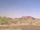 Palo Verde Mountains, Imperial County, California, with Milpitas Wash in the foreground. Palo Verde Mountains, Imperial County, California, with Milpitas Wash in the foreground.
|
||||||
|
Other articles:
|
||||||
|
Other articles:
Locations:
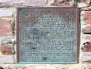
Ben Hulse Monument.
|
| |||||
|
Literature Cited:
Other articles:
|
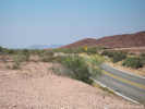
Near the Ben Hulse Monument is an outcrop of the Lawlor Tuff in Bouse Formation sediments. This outcrop demonstrates than the high stand of water here reached 330 m (1080 ft) when the Lawlor Tuff was deposited at 4.83 Ma. | |||||
|
Other articles:
|
||||||
|
Literature Cited:
Locations: Salton Trough. |
Entering the Salton Trough, below, and to the west. | |||||
| Junction: California Highway 115, South. | ||||||
| Junction: California Highway 115, North. | ||||||
|
Other articles:
|
Junction: California Highway 111, South. | |||||
|
Other articles:
|
Junction: California Highway 111, North. | |||||
|
|
Brawley | |||||
|
Other articles:
|
Junction: California Highway 86, South. | |||||
|
Other articles:
|
WestmorelandJunction: County Route S30, North Center Street, Forrester Road, all names for the same physical road. | |||||
|
Other articles:
|
Junction: California Highway 86, North. | |||||
|
Imperial County above
San Diego County below | ||||||
|
Literature Cited:
Locations: Salton Trough. |
To the east, California Highway 78 enters the Salton Trough. | |||||
|
Other articles:
Locations: Ocotillo Wells. |
Ocotillo WellsJunction: Split Mountain Road, south to Fish Creek and the gypsum mine. | |||||
| Junction: Split Mountain Road | ||||||
| Junction: Borrego Springs Road | ||||||
| The Narrows | ||||||
|
Literature Cited:
Locations: Yaqui Ridge. |
Yaqui Ridge to the north. Luther and Axen (2013) examined geologic paleostress inversion from a segment of the folded West Salton detachment fault located on Yaqui Ridge, a left stepover in the San Felipe dextral fault zone of Southern California. Their data suggest that the tectonic transition from extension to dextral faulting may have occurred under very low differential stress levels, and, if this is true, then it also is likely that both the SAF and low-angle normal faults are very weak. | |||||
| Junction: County Hwy S3 “Yaqui Pass Road” | ||||||
| Junction: California Highway 79 | ||||||
|
Other articles:
|
Junction: US Interstate 15 | |||||
|
Other articles:
|
Junction: US Interstate 5 | |||||
| If you have a question or a comment you may write to me at: tas4@schweich.com I sometimes post interesting questions in my FAQ, but I never disclose your full name or address. |
Date and time this article was prepared: 5/10/2024 10:58:12 AM |