Eastern Mojave Vegetation
|
Eastern Mojave Vegetation
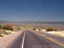
| Antelope Valley, Eureka County, Nevada. |
|
Gazetteer Query: G.N.I.S.
|
||
|
South of US Highway 50. Located 16.5 mi E of Monitor Valley and 10 mi S of Koben Valley, bounded on the W by Toiyabe National Forest, on the N by Bean Flat and Lone Mountain, on the E by the Mohagany Hills and White Cloud Peak, on the S by Horse Heaven Mountain and Ninemile Peak.
Articles that refer to this location:
| ||
| No collections made at this location. | ||
| If you have a question or a comment you may write to me at: tas4@schweich.com I sometimes post interesting questions in my FAQ, but I never disclose your full name or address. |
A, B, C,
D, E, F,
G, H, I,
J, K, L,
M, Date and time this article was prepared:3:32:33 PM, 4/27/2024. | |