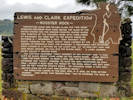
Lewis and Clark Expedition
Rooster Rock
Meriwether Lewis and William Clark,
the two great American explorers who made secure the claim of the
United States for the Oregon country,
passed along this stretch of the Columbia River with their
Corps of Discovery on their way to the Pacific Ocean on
October 31 -- November 2, 1805.
They brought their boats through the “Great Shute”
(now covered by the waters of Bonneville Dam)
and recorded
“a remarkable high detached rock stands in a bottom on the
stard side ... [it is] 800 feet high and
400 paces around, we call [it] the beaten rock.”
A later journal entry called it Beacon Rock.
The captains described
“great numbers of sea otters” and
“a high clift of black rocks” (Cape Horn) on the north shore.
Clark wrote “here the river widens to near a mile,
and the bottoms are more extensive and thickly timbered,
as also the high mountains on each side ...
passed a rock near the middle of the river,
about 100 feet high and 80 feet diameter [Phoca Rock] ...
we encamped under a high projecting rock on the lard [Rooster Rock].”
The expedition camped in this area April 6-9, 1806, on their return journey.
They noted that Beacon Rock “may be esteemed the head of tidewater.”
|
Elevation: 46ft, 14m.
Articles that refer to this location:
|
|
If you have a question or a comment you may write to me at:
tas4@schweich.com
I sometimes post interesting questions in my FAQ, but I never disclose your full name or address.
|
A, B, C,
D, E, F,
G, H, I,
J, K, L,
M,
N, O,
P, Q, R,
S, T, U,
V, W, X,
Y, Z
[Home Page] [Site Map]
Date and time this article was prepared:3:33:22 PM, 4/27/2024.
|
 Eastern Mojave Vegetation