Eastern Mojave Vegetation
Tom Schweich
|
Eastern Mojave Vegetation
| California Highway 33 |
|
Tom Schweich |

|
California Highway 33 runs from Coalinga in the north to Ventura in the south, passing throught Avenal, McKittrick, Taft, Maricopa, and Ojai along the way. |
|
Other articles:
|
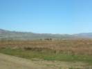
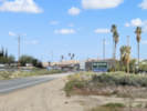
View northwest from Coalinga. |
|
Other articles:
Locations: Coalinga. |
Coalinga |
|
Other articles:
|
|
|
Other articles:
|
|
|
Other articles:
|
|
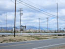
| Kettleman Station | |
|
Literature Cited:
Locations: Canoas Creek. Kreyenhagen Hills. Reef Ridge. |
Canoas Creek. Approximately 6 miles to the southwest, where Canoas Creek passes through Reef Ridge is the type locality of the Kreyenhagen Shale. |
|
|
Avenal |
|
Other articles:
|
Junction: California Highway 41, west to Atascadero, or east to Fresno. |
|
Other articles:
Locations: Blackwells Corners. |
Blackwells CornersJunction: California Highway 46, west to Paso Robles, or east to Wasco and CA Highway 99. |
 Blackwells Corners, "World's Largest Parking Lot" Blackwells Corners, "World's Largest Parking Lot"
|
|
|
Other articles:
|
Junction: California Highway 58, east to Bakersfield and Barstow. |
|
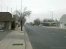
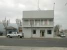
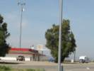
Locations: McKittrick. |
McKittrick |
|
Other articles:
|
|
|
Other articles:
|
Junction: California Highway 58, west to US Highway 101 near Santa Margarita. |
|
Other articles:
|
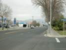
Between McKittrick and Taft. |
|
|
Taft |
|
Other articles:
|
MaricopaJunction: California Highway 166, east to I-5 and CA Hwy 99. |
|
Other articles:
|
Junction: California Highway 166, west to Santa Maria. |
|
|
Ojai |
|
|
Ventura |
|
Other articles:
|
Junction: US Highway 101 |
| If you have a question or a comment you may write to me at: tomas@schweich.com I sometimes post interesting questions in my FAQ, but I never disclose your full name or address. |
Date and time this article was prepared: 5/12/2025 2:42:43 PM |