Eastern Mojave Vegetation
Tom Schweich
|
Eastern Mojave Vegetation
| Monterey County Route G16 |
|
Tom Schweich |

|
(No Preface) |
|
Other articles:
|
Junction: California Highway 1 |
|
Junction: Monterey County Route G20 Also known as "Laureles Grade Road." | |
|
|
Carmel Valley |
| Hastings Natural History State Reservation | |
|
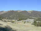
Locations:
Sierra de Salinas.
|
|
|
Other articles:
|
Junction: Arroyo Seco Road, west to Arroyo Seco Recreation Area, east to Greenfield on Monterey County Route G16. |
|
Other articles:
|
Junction:
|
|
Literature Cited:
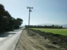
Locations: Reliz Canyon. |
Junction: Reliz Canyon Road
Finnegan and Balco (2013) analyzed the formation of bedrock river terraces along Arroyo Seco where it crosses the Reliz Canyon Fault |
|
Other articles:
|
GreenfieldJunction: El Camino RealGo south for US Hwy 101 south, go north for US Hwy 101 north. |
|
Other articles:
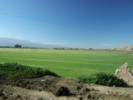
Locations:
Salinas Valley.
|
Near the east side of the valley, and the east end of County Route 16, there is a grass farm. |
|
Other articles:
Locations:
Salinas Valley.
|
Grass farm on the north side of the road. |
|
Other articles:
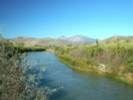
Locations:
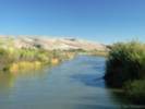
North Chalone Peak.
Salinas River.
|
Salinas River looking downstream to the north. North and South Chalone Peaks in the distance. |
|
Other articles:
Locations:
Salinas River.
|
Salinas River looking upstream to the south. |
|
Other articles:
|
Junction: Monterey County Route G15, also known as Metz Road, north to California Highway 146, or south to King City. |
| If you have a question or a comment you may write to me at: tomas@schweich.com I sometimes post interesting questions in my FAQ, but I never disclose your full name or address. |
Date and time this article was prepared: 5/12/2025 2:44:10 PM |