Eastern Mojave Vegetation
Tom Schweich
|
Eastern Mojave Vegetation
| California Highway 1 |
|
Tom Schweich |

|
(No Preface) | ||||||||||||||||||||||||||||||||||||||||||||||||||||||||||||||||||||||||||||||||||||||||||||||||||||||||||||
|
Other articles:
Locations: Leggett. |
LeggettJunction: U. S. Highway 101. | ||||||||||||||||||||||||||||||||||||||||||||||||||||||||||||||||||||||||||||||||||||||||||||||||||||||||||||
|
Other articles:
|
Junction: Branscomb Road, east to US Highway 101 at Laytonville. | ||||||||||||||||||||||||||||||||||||||||||||||||||||||||||||||||||||||||||||||||||||||||||||||||||||||||||||
|
|
Westport | ||||||||||||||||||||||||||||||||||||||||||||||||||||||||||||||||||||||||||||||||||||||||||||||||||||||||||||
|
Locations: Fort Bragg. |
Fort BraggJunction: East and West Laurel Street | ||||||||||||||||||||||||||||||||||||||||||||||||||||||||||||||||||||||||||||||||||||||||||||||||||||||||||||
|
Other articles:
|
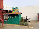
Egghead's Restaurant | ||||||||||||||||||||||||||||||||||||||||||||||||||||||||||||||||||||||||||||||||||||||||||||||||||||||||||||
|
Other articles:
|
Junction: California Highway 1 | ||||||||||||||||||||||||||||||||||||||||||||||||||||||||||||||||||||||||||||||||||||||||||||||||||||||||||||
|
|
Mendocino | ||||||||||||||||||||||||||||||||||||||||||||||||||||||||||||||||||||||||||||||||||||||||||||||||||||||||||||
|
Other articles:
|
Junction: California Highway 128. | ||||||||||||||||||||||||||||||||||||||||||||||||||||||||||||||||||||||||||||||||||||||||||||||||||||||||||||
|
Literature Cited:
Locations: Alder Creek. |
Cross Alder Creek. Here, Cashman, et al. (2007) investigated microstructures developed by coseismic and aseismic faulting in near-surface sediments along the San Andreas Fault. The other locality reported was Flook Ranch, near Bitterwater, San Benito County. | ||||||||||||||||||||||||||||||||||||||||||||||||||||||||||||||||||||||||||||||||||||||||||||||||||||||||||||
|
|
Point Arena | ||||||||||||||||||||||||||||||||||||||||||||||||||||||||||||||||||||||||||||||||||||||||||||||||||||||||||||
|
Other articles:
Locations:
Gualala.
|
Gualala
| ||||||||||||||||||||||||||||||||||||||||||||||||||||||||||||||||||||||||||||||||||||||||||||||||||||||||||||
|
Locations: Gualala River. |
Mendocino County above
Cross Gualala River. Sonoma County below | ||||||||||||||||||||||||||||||||||||||||||||||||||||||||||||||||||||||||||||||||||||||||||||||||||||||||||||
|
|
Stewarts Point | ||||||||||||||||||||||||||||||||||||||||||||||||||||||||||||||||||||||||||||||||||||||||||||||||||||||||||||
|
|
Fort Ross | ||||||||||||||||||||||||||||||||||||||||||||||||||||||||||||||||||||||||||||||||||||||||||||||||||||||||||||
|
Literature Cited:
Locations: Jenner. |
Jenner | ||||||||||||||||||||||||||||||||||||||||||||||||||||||||||||||||||||||||||||||||||||||||||||||||||||||||||||
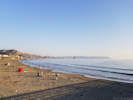
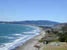
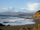
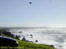 Salmon Creek Beach just north of Bodega Bay. Salmon Creek Beach just north of Bodega Bay.
|
|||||||||||||||||||||||||||||||||||||||||||||||||||||||||||||||||||||||||||||||||||||||||||||||||||||||||||||
|
Locations:
Bodega Bay.
|
Bodega Bay | ||||||||||||||||||||||||||||||||||||||||||||||||||||||||||||||||||||||||||||||||||||||||||||||||||||||||||||
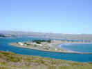
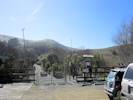
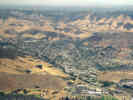
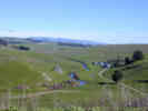 Looking east across countryside north of Tomales. Looking east across countryside north of Tomales.
|
|||||||||||||||||||||||||||||||||||||||||||||||||||||||||||||||||||||||||||||||||||||||||||||||||||||||||||||
|
Locations:
Tomales.
|
Tomales | ||||||||||||||||||||||||||||||||||||||||||||||||||||||||||||||||||||||||||||||||||||||||||||||||||||||||||||
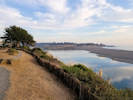
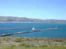
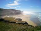
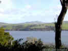 Looking east across Tomales Bay. Looking east across Tomales Bay.
|
|||||||||||||||||||||||||||||||||||||||||||||||||||||||||||||||||||||||||||||||||||||||||||||||||||||||||||||
|
|
Point Reyes Station | ||||||||||||||||||||||||||||||||||||||||||||||||||||||||||||||||||||||||||||||||||||||||||||||||||||||||||||
|
Other articles:
|
Junction: Sir Francis Drake Boulevard, west to Point Reyes. | ||||||||||||||||||||||||||||||||||||||||||||||||||||||||||||||||||||||||||||||||||||||||||||||||||||||||||||
|
Other articles:
|
Junction: Bear Valley Road, to Point Reyes National Seashore headquarters and Bear Valley Trailhead. | ||||||||||||||||||||||||||||||||||||||||||||||||||||||||||||||||||||||||||||||||||||||||||||||||||||||||||||
|
Locations: Olema. |
Olema | ||||||||||||||||||||||||||||||||||||||||||||||||||||||||||||||||||||||||||||||||||||||||||||||||||||||||||||
|
Other articles:
|
Junction: Sir Francis Drake Boulevard, east past Woodacre and Fairfax to US Interstate 580 near the Richmond-San Rafael Bridge. | ||||||||||||||||||||||||||||||||||||||||||||||||||||||||||||||||||||||||||||||||||||||||||||||||||||||||||||
|
Locations: Olema Creek. Pine Gulch Creek. |
West from the Randall Trail trailhead, there is a little spur trail that leads to the Olema Valley Trail. Out in Olema Valley, Olema Creek is flowing northwest into Tomales Bay. A hundred meters or so further west isPine Gulch Creek, flowing southeast to Bolinas Lagoon. A shutter ridge, raised by pressure on the San Andreas fault, separates the two creeks. While the juxtaposition of the two creeks is easily seen on a map, it is much harder to see in the field. Olema Creek is a limpid little creek in this location, with barely any current. Pine Gulch Creek is mostly hidden from view, as the Olema Valley Trail keeps to the tops of the shutter ridges between the two creeks. | ||||||||||||||||||||||||||||||||||||||||||||||||||||||||||||||||||||||||||||||||||||||||||||||||||||||||||||
|
Other articles:
|
Junction: Olema-Bolinas Road, into Bolinas, or to Mesa Road and the Palomarin trailhead of Point Reyes National Seashore. | ||||||||||||||||||||||||||||||||||||||||||||||||||||||||||||||||||||||||||||||||||||||||||||||||||||||||||||
|
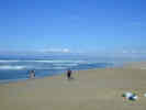
Locations: Stinson Beach. |
Stinson Beach | ||||||||||||||||||||||||||||||||||||||||||||||||||||||||||||||||||||||||||||||||||||||||||||||||||||||||||||
 Stinson Beach from California Highway 1 Stinson Beach from California Highway 1
|
|||||||||||||||||||||||||||||||||||||||||||||||||||||||||||||||||||||||||||||||||||||||||||||||||||||||||||||
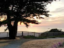
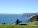 Cheryl surveys the coast from Muir Beach Overlook. Cheryl surveys the coast from Muir Beach Overlook.
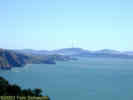 San Francisco from Muir Beach Ovelook. San Francisco from Muir Beach Ovelook.
|
|||||||||||||||||||||||||||||||||||||||||||||||||||||||||||||||||||||||||||||||||||||||||||||||||||||||||||||
|
Locations:
Muir Beach.
|
Muir Beach | ||||||||||||||||||||||||||||||||||||||||||||||||||||||||||||||||||||||||||||||||||||||||||||||||||||||||||||
|
Other articles:
|
Mill ValleyJunction: U. S. Highway 101. | ||||||||||||||||||||||||||||||||||||||||||||||||||||||||||||||||||||||||||||||||||||||||||||||||||||||||||||
|
From Mill Valley south to San Francisco, California Highway 1 follows the route of U. S. Highway 101. | |||||||||||||||||||||||||||||||||||||||||||||||||||||||||||||||||||||||||||||||||||||||||||||||||||||||||||||
|
Other articles:
|
San FranciscoJunction: U. S. Highway 101. | ||||||||||||||||||||||||||||||||||||||||||||||||||||||||||||||||||||||||||||||||||||||||||||||||||||||||||||
|
Other articles:
|
Junction: US Interstate 280, North, to US Highway 101 and downtown San Francisco. | ||||||||||||||||||||||||||||||||||||||||||||||||||||||||||||||||||||||||||||||||||||||||||||||||||||||||||||
| For a short distance through Daly City, California Highway 1 and US Interstate 280 share the same route. | |||||||||||||||||||||||||||||||||||||||||||||||||||||||||||||||||||||||||||||||||||||||||||||||||||||||||||||
|
Other articles:
|
Junction: US Interstate 280, South, along the San Andreas Rift Zone to San Jose. | ||||||||||||||||||||||||||||||||||||||||||||||||||||||||||||||||||||||||||||||||||||||||||||||||||||||||||||
|
Other articles:
|
Junction: California Highway 92, east to San Mateo, across the Bay to Hayward. | ||||||||||||||||||||||||||||||||||||||||||||||||||||||||||||||||||||||||||||||||||||||||||||||||||||||||||||
|
Other articles:
|
Junction: California Highway 84, east through La Honda to Woodside, and US Interstate 280. | ||||||||||||||||||||||||||||||||||||||||||||||||||||||||||||||||||||||||||||||||||||||||||||||||||||||||||||
|
Other articles:
Locations:
San Gregorio Beach.
|
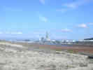
San Gregorio State Beach
| ||||||||||||||||||||||||||||||||||||||||||||||||||||||||||||||||||||||||||||||||||||||||||||||||||||||||||||
| Junction: Pescadero Creek Road | |||||||||||||||||||||||||||||||||||||||||||||||||||||||||||||||||||||||||||||||||||||||||||||||||||||||||||||
| Junction: Pigeon Point Drive | |||||||||||||||||||||||||||||||||||||||||||||||||||||||||||||||||||||||||||||||||||||||||||||||||||||||||||||
| Junction: Gazos Creek Road | |||||||||||||||||||||||||||||||||||||||||||||||||||||||||||||||||||||||||||||||||||||||||||||||||||||||||||||
|
|
Año Neuvo State Reserve | ||||||||||||||||||||||||||||||||||||||||||||||||||||||||||||||||||||||||||||||||||||||||||||||||||||||||||||
|
San Mateo County above
Santa Cruz County below | |||||||||||||||||||||||||||||||||||||||||||||||||||||||||||||||||||||||||||||||||||||||||||||||||||||||||||||
|
Other articles:
|
Santa CruzJunction: California Highway 17, north to San Jose. | ||||||||||||||||||||||||||||||||||||||||||||||||||||||||||||||||||||||||||||||||||||||||||||||||||||||||||||
Junction: California Highway 9
|
|
Literature Cited:
Locations: San Lorenzo River.
Cross San Lorenzo River. | Warrick and Barnard (2012) studied sedimentation at the mouths of the San Lorenzo and Santa Clara Rivers after substantial flood events. They found that the amount of sand delivered to the littoral cells was substantially different between the two rivers.
|
Junction: California Highway 17
|
|
Other articles:
Junction: California Highway 152, east through the coast ranges to the San Joaquin Valley.
|
|
Locations:
Elkhorn Slough.
Moss Landing.
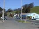
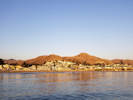
| Moss Landing
|
Other articles:
Junction: Monterey County Route G17. | Monterey County Route G17 follows the southeast bank of the Salinas River, between the river and the Sierra de Salinas, as far south as Arroyo Seco.
|
Other articles:
Junction: California Highway 68., east to Laguna Seca and Salinas.
|
|
| Monterey
|
Other articles:
Junction: California Highway 68, west to Asilomar.
|
|
Other articles:
Junction: Monterey County Route G16
|
|
Literature Cited:
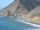
Locations: Hurricane Point.
Hurricane Point, about 2 miles north of the Little Sur River.
|
|
| Big Sur
|
Julia Pfeiffer Burns State Park
|
|
Locations: Big Creek.
Big Creek.
|
|
Other articles:
Bridge over Big Creek to the north.
|
|
| Lucia
|
Big Slide ( 36.014983,-121.528973)
|
|
Literature Cited:
Locations: Pitkins Curve.
Pitkins Curve (36.009911, -121.523390)
|
|
Kirk Creek Campground
|
|
Other articles:
Locations:
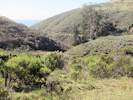
Willow Creek.
Willow Creek
|
|
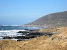
Locations: Gorda.
| Gorda
|
Literature Cited:
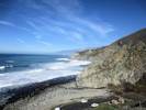
Locations: Grayslip.
Grayslip (35.825475,-121.383377)
|
|
Salmon Creek
|
|
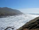
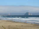
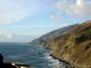 California coast line north of Ragged Point California coast line north of Ragged Point
|
|
Locations: Ragged Point.
| Ragged Point
|
 Elephant Seals along CA Highway 1 Elephant Seals along CA Highway 1
 Elephant Seal watching Elephant Seal watching
|
|
| San Simeon
|
Other articles:
| Junction: Moonstone Beach Road
|
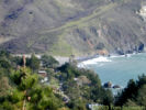
 Moonstone Beach near Cambria. Moonstone Beach near Cambria.
|
|
 Moonstone Beach just north of Cambria. Moonstone Beach just north of Cambria.
|
|
Other articles:
| Junction: Windsor Blvd., Moonstone Beach Road
|
Locations: Cambria.
| Cambria
|
Other articles:
Junction: California Highway 46, east to Paso Robles.
|
|
Other articles:
Locations:
Harmony Headlands State Park.
| Harmony Headlands State Park
|
Locations:
Cayucos.
| Cayucos
|
Other articles:
| at CA Hwy 41Junction: California Highway 41, Atascadero Road
|
Other articles:
| at Main St.Junction: Main Street
|
Locations: Morro Bay.
| Morro Bay
|
Other articles:
| at Morro Bay BlvdJunction: Morro Bay Blvd.
|
Other articles:
Locations:
San Luis Obispo.
| San Luis ObispoJunction: U. S. Highway 101.San Luis Obispo was founded as the Mission San Luis Obispo de Tolosa in 1772 by Father Junípero Serra. The mission was named after Saint Louis, a 13th Century Bishop of Toulouse, France. Mission San Luis Obispo de Tolosa was the fifth mission in the California chain of 21 missions along El Camino Real. The closest mission to the south is La Purisima Concepcion, while the closest mission to the north is San Miguel Arcangel. The City of San Luis Obispo serves as the commercial and cultural hub of Californias Central Coast, as well as being the county seat of San Luis Obispo County. One of Californias oldest communities, the city was was first incorporated in 1856. With a population of 44,000, the City is located eight miles from the Pacific Ocean and is midway between San Francisco and Los Angeles at the junction of Highway 101 and scenic Highway 1. A well-known state university and my alma mater, California Polytechnic State University, is located on the north edge of town.
|
| From San Luis Obispo south to Pismo Beach, California Highway 1 follows the route of US Highway 101.
|
Other articles:
| Pismo BeachJunction: U. S. Highway 101.
|
Other articles:
Junction: Jalama Road
|
|
Other articles:
| Las CrucesJunction: U. S. Highway 101.
|
| From Las Cruces south to Oxnard, California Highway 1 follows the route of US highway 101.
|
Other articles:
| OxnardJunction: U. S. Highway 101.
|
| Malibu
|
Other articles:
Junction: US Interstate 10, east to Jacksonville, Florida.
|
|
| Newport Beach
|
Other articles:
| Laguna BeachJunction: California Highway 133, through Irvine to California Highway 241.
|
Other articles:
Junction: Park Avenue,, up the hill to Alta Laguna Boulevard and Park.
|
|
Other articles:
| Dana PointJunction: U. S. Highway 101.
If you have a question or a comment you may write to me at:
tomas@schweich.com
I sometimes post interesting questions in my FAQ, but I never disclose your full name or address.
|
|
Date and time this article was prepared: 4/21/2025 8:14:12 PM |