Eastern Mojave Vegetation
Tom Schweich
|
Eastern Mojave Vegetation
| San Benito County Route G1 |
|
Tom Schweich |

|
Known also in varying places as "The Alameda" and "San Juan Canyon Road," this route goes from its intersection with State Highway 156 at the south edge of San Juan Bautista to Fremont Peak State Park. |
|
Other articles:
|
Junction: CA Highway 156 |
|
Other articles:
|
Junction: San Benito County Route 3, also known as "San Juan Grade Road." |
| Enter San Juan Canyon, the road adds the name of "San Juan Canyon Road." | |
| Road loses "The Alameda" name. | |
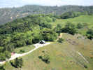
| Enter Fremont Peak State Park. | |
|
Locations:
Fremont Peak.
|
|
|
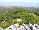
Locations:
Fremont Peak.
|
|
|
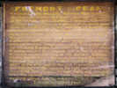
Locations:
Fremont Peak.
|
|
| End of Road. Parking Lot. | |
| If you have a question or a comment you may write to me at: tomas@schweich.com I sometimes post interesting questions in my FAQ, but I never disclose your full name or address. |
Date and time this article was prepared: 5/12/2025 2:44:28 PM |