Eastern Mojave Vegetation
Tom Schweich
|
Eastern Mojave Vegetation
| Crucero Road, San Bernardino County, California |
|
Tom Schweich |

|
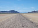
North! from Ludlow! | ||
|
Locations: Crucero. |
Crucero | ||
| Junction: Union Pacific maintenance road. | |||
|
Crucero Crossing -- Closed. | |||
|
Other articles:
|
Junction: Union Pacific maintenance road, south side of the tracks. | ||
|
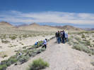
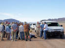
Desert Symposium Stop 2017-1-3. Mesquite Fault.
Inspect the mesquite lineament that runs more than 1 km east-southeast on one fault splay (Phelps, help!) along the north face of the Mesquite Hills, and which runs west from this point to the T & T railroad grade. It is common to find spring and wetland activity along traces of faults that serve as local dams to groundwater. | |||
|
Other articles:
Locations:
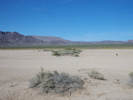
Mesquite Spring.
|
Ground water deposits and shoreline benches (lake vs. spring); and strike-slip fault (Phelps, XXX). The mounds of carbonate silts on which mesquite grow have been interpreted as GWD deposits based on the poor stratification of carbonate-rich fines appropriate for eolian dust and carbonate precipitation in springs and wetlands (e.g., Pigati et al, 201x). However, flat benches that front the bedrock of the hills just south of these mounds are nearly horizontal, resembling shorelines cut by waves of a big lake. Hale (R. Hale, FOP, 19XX; R.L. Hooke, 1999) interpreted these features as forming in a huge lake that was continuous from here to northern Death Valley. By this interpretation, the lake must have been old because it has been deformed and nearly all evidence for such big beaches have vanished. Early Holocene age of dated Anodonta from these deposits (M. Reheis, p.c. to Miller 2012) make this interpretation unattractive. Alternatively, we suggest that sapping at the margin of a wetland can cause benches such as these. Reconnaissance surficial geologic mapping here by Miller (Miller et al, 2007) demonstrated the presence of an ~east striking fault or series of fault segments that cut Quaternary fan deposits. Recent mapping by Phelps has greatly refined this work . GAP to add more here . | ||
|
Other articles:
|
The Mojave Megaphone | ||
|
Desert Symposium View 1A.
View southwest of canyons in the eastern Cady Mountains leading toward Hidden Valley. Although the Cady Fault runs through Hidden Valley west toward the Manix and Calico Faults near Harvard Hill, it does not project straight eastward into Broadwell Valley (Schmidt, herein). | |||
|
Desert Symposium View 2017-1B.
Drainage divide in alluvial saddle between the Cady and Bristol Mountains. (572750 3863100) As we continue south on the road, faults form scarps near hill-fronts on both sides of this valley. The faults on the west form front-facing scarps (face downslope toward the observer) in the steep boulder fans (Phelps et al, 201x). | |||
| Powerlines | |||
|
Desert Symposium View 2017-1C.
One probable fault to the east is represented by a steep, high linear escarpment cut in middle Pleistocene fan deposits. The scarp is straight, and unlikely to have formed by stream side-cutting because fans here flow west before turning south toward Broadwell Lake. On the west, aligned toes of dark fans are hidden by the T & T grade. | |||
|
Locations: Broadwell. |
Broadwell | ||
| North end of Broadwell Playa. | |||
|
Locations: Broadwell Lake. |
Broadwell Lake | ||
|
Other articles:
|
VIEW EAST of lineament of creosote (Larrea tridentata) and cattle spinach (Atriplex sp.) bushes that mark one of several fissures on Broadwell Lake Playa. A 0.7 mile hike northeast across the playa and the T & T grade will reach the east end of the fissure. NOTE: Wilderness Land is east of the T&T Berm. Walk, but do not drive east of the T&T Berm. Return to vehicles. Proceed south toward second powerline crossing. In January, 2017, the playa received heavy rain. The elevation at the center of the playa is 1297, and flotsam suggests that the lake filled to 1301 feet, with the shoreline within six feet of the road. | ||
| South end of Broadwell Playa. | |||
|
Other articles:
|
Junction: Powerline Road. To the east this powerline passes through the Bristol Mountains, between the Kelso Dunes and the Granite Mountains, past the Vulcan Mine and Foshay Pass, then | ||
|
Other articles:
Locations: Ludlow. |
Junction: US Interstate 40, west to Barstow, east fo Needles. | ||
| If you have a question or a comment you may write to me at: tomas@schweich.com I sometimes post interesting questions in my FAQ, but I never disclose your full name or address. |
Date and time this article was prepared: 4/21/2025 8:16:07 PM |