Eastern Mojave Vegetation 
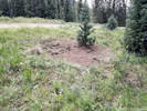
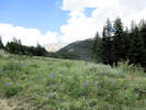
Forest Road 134 “Trail Road,” San Isabel National Forest, Lake County, Colorado  
 

Tom Schweich  

Home Page  From Colorado State Highway 91, up Chalk Creek, in the direction of Chalk Mountain.


Chalk Mountain

Top of Chalk Mountain, end of road.
  Junction: Forest Road 134A (?), farther up Chalk Creek to Columbine Ditch.

Literature Cited:
- Greene, Edward L., 1894.
- Greene, Edward L., 1901.

Other articles:
• Field Notes:   23 Jul 2018;  Coll. No. 1984, 23 Jul 2018;  Coll. No. 1985, 23 Jul 2018;  Coll. No. 1986, 23 Jul 2018;  Coll. No. 1987, 23 Jul 2018;  Coll. No. 1988, 23 Jul 2018;  Coll. No. 1989, 23 Jul 2018;  Coll. No. 1990, 23 Jul 2018;

Locations: Chalk Creek.  

Full Size Image
Wonder what is buried here.
Full Size Image
Collecting Locality, Coll. Nos. 1984-90
Full Size Image
Collecting Locality, Coll. Nos. 1984-90
Full Size Image
Coll. No. 1984, Lupinus argenteus var. rubricaulis
Full Size Image
Coll. No. 1985, Leptosiphon nuttalli subsp. nuttalli
Full Size Image
Coll. No. 1986, Heterotheca pumila
Full Size Image
Coll. No. 1988, Erigeron subtrinervis
Full Size Image
Coll. No. 1989, Potentilla pulcherrima
Full Size Image
Coll. No. 1990, Helianthella quinquenervis
Full Size Image
Red-tipped glands in the inflorescence of Coll. No. 1989, Potentilla pulcherrima
Between the pipeline and the power line is a small level spot. I made seven collections here on July 23, 2018.

Other articles:
• CO Highway 91:   at FR 134;  

Junction: Colorado State Highway 91, south to Leadville, or north to Climax and Copper Mountain.
If you have a question or a comment you may write to me at: tomas@schweich.com I sometimes post interesting questions in my FAQ, but I never disclose your full name or address.  


[Home Page] [Site Map]

Date and time this article was prepared: 7/13/2024 8:05:57 AM