Eastern Mojave Vegetation
|
Eastern Mojave Vegetation
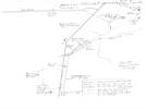
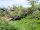
| Ramstetter Creek, Jefferson County, Colorado. |
|
Gazetteer Query: G.N.I.S. See also: North Table Mountain Park. See also: Ramstetter Reservoir.
|
||
|
Named for Ernest Ramstetter (1891-1961) and his wife Gladys (1897-1988), longtime ranchers and farmers in the area. Heads in Ramstetter Reservoir, 0.8 km (0.5 mi) north of the Golden corporate boundary; flows northeast then east along the north edge of North Table Mountain to enter an unnamed stream that intersects Van Bibber Creek, 1.3 km (0.8 mi) south southwest of Boyd Lake.
Articles that refer to this location:
| ||
| No collections made at this location. | ||
| If you have a question or a comment you may write to me at: tomas@schweich.com I sometimes post interesting questions in my FAQ, but I never disclose your full name or address. |
A, B, C,
D, E, F,
G, H, I,
J, K, L,
M, Date and time this article was prepared:8:32:06 PM, 4/21/2025. | |