Eastern Mojave Vegetation
Tom Schweich
|
Eastern Mojave Vegetation
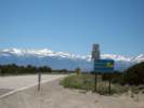
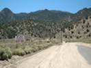
| Nevada Highway 359 |
|
Tom Schweich |

|
Nevada State Route 359 is also known in some parts as Pole Line Road. |
|
Other articles:
|
California State Line |
|
Other articles:
|
|
|
Literature Cited:
Other articles:
|
|
|
Other articles:
|
Junction: Forest Road 058 and Power Line Road, turn north here for Alkali Valley, Larkin Lake, or Aurora. |
|
Other articles:
|
|
|
Other articles:
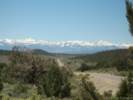
Locations: Mono Basin. |
Mono Lake basin above, to the west |
|
Other articles:
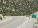
Locations:
Anchorite Pass.
|
Anchorite Pass |
|
Walker Lake basin below, to the northeast | |
|
Other articles:
|
|
|
Other articles:
Locations: Whiskey Flat. |
Whiskey FlatJunction:
|
|
Literature Cited:
|
Alum Creek to the west. Somewhere along Alum Creek is a probable debris flow deposit stidied by Bell and House (2007) in their study of the relationship between Plinian eruptions in the Mono Craters and overlying debris flow deposits. |
|
Other articles:
|
Junction: Lucky Boy Pass Road |
|
Literature Cited:
|
Corey Creek to the west. Somewhere along Corey Creek is a probable debris flow deposit stidied by Bell and House (2007) in their study of the relationship between Plinian eruptions in the Mono Craters and overlying debris flow deposits. |
|
Literature Cited:
|
Copper Canyon to the west. Somewhere in Copper Canyon is a probable debris flow deposit stidied by Bell and House (2007) in their study of the relationship between Plinian eruptions in the Mono Craters and overlying debris flow deposits. |
|
Other articles:
Locations: Hawthorne. |
HawthorneJunction: U. S. Highway 95, north past Walker Lake to Fallon, south to Tonopah and Las Vegas. |
| If you have a question or a comment you may write to me at: tomas@schweich.com I sometimes post interesting questions in my FAQ, but I never disclose your full name or address. |
Date and time this article was prepared: 4/21/2025 8:28:13 PM |