Eastern Mojave Vegetation
Tom Schweich
|
Eastern Mojave Vegetation
| Nevada State Route 225 “Mountain City Highway” |
|
Tom Schweich |

|
(No Preface) | ||||||||||||||||||||||||||||||||||||
|
Other articles:
|
Junction: Idaho State Route 51 Idaho Above Nevada below. | ||||||||||||||||||||||||||||||||||||
|
Locations: Owyhee. |
Owyhee | ||||||||||||||||||||||||||||||||||||
|
Locations: Duck Valley Indian Reservation. |
Duck Valley Reservation above
Humboldt National Forest below | ||||||||||||||||||||||||||||||||||||
|
Other articles:
Locations:
Mountain City.
|
Mountain CityIn 1870, Mountain City was made after a silver mine was found in the area. Over a thousand people lived in Mountain City until the silver eventually ran out. Causing the town to lose over a thousand people. In 1879, copper was found at one of the mines North-East of Mountain City. People came rooling back in, causing a Boom Town, and played out until the copper eventually ran out. A post office was established at Mountain City in 1870. The community was descriptively named on account of the natural surroundings of its elevated town site. Due to its small size, Mountain City is classified by some writers as a ghost town. As 2023, no new buildings or places have been built or constructed for Mountain City. The local-town bar has been keeping Mountain City alive for 20 years. The Duck Valley Indian Reservation Council fires anyone who goes to or is seen coming out of the bar.
| ||||||||||||||||||||||||||||||||||||
|
Locations: Yankee Bill Gulch. |
Junction: National Forest Developed Road 16, east then north about 6.5 miles in the direction of Yankee Bill Gulch. | ||||||||||||||||||||||||||||||||||||
|
Other articles:
Locations:
Patsville.
Rio Tinto.
|
PatsvilleJunction: Road to Rio Tinto
| ||||||||||||||||||||||||||||||||||||
|
Junction: Nevada State Route 11A | |||||||||||||||||||||||||||||||||||||
|
Other articles:
Locations:
Owyhee River.
|
| ||||||||||||||||||||||||||||||||||||
|
Other articles:
Locations:
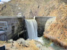
Wild Horse Dam.
|
Wild Horse Dam
| ||||||||||||||||||||||||||||||||||||
|
Humboldt National Forest above | |||||||||||||||||||||||||||||||||||||
|
Junction: FR037 “Gold Creek Road”, on the west to Wild Horse State Recreation Area, to the east into the mountains. | |||||||||||||||||||||||||||||||||||||
|
Other articles:
Locations:
Wild Horse Reservoir.
|
Wild Horse Reservoir
| ||||||||||||||||||||||||||||||||||||
|
Locations: Hot Creek. |
Cross Hot Creek at an embayment of Wild Horse Reservoir | ||||||||||||||||||||||||||||||||||||
|
Locations: Owyhee River. |
Cross Owyhee River. | ||||||||||||||||||||||||||||||||||||
|
Locations: Wild Horse. |
Wild HorseCurrently occupied by the Wild Horse Ranch & Resort. History unclear. | ||||||||||||||||||||||||||||||||||||
|
Other articles:
|
|||||||||||||||||||||||||||||||||||||
|
Other articles:
|
Snake River, Columbia Basin above North of Four Mile Creek and south of Delaware Creek is the divide between N. Fork Humboldt River of the Great Basin to the south and Owyhee River of the Snake-Columbia basin to the north. Humboldt River, Great Basin below | ||||||||||||||||||||||||||||||||||||
|
Locations: Independence Mountains. |
Junction: National Forest Road 473, west through the Independence Mountains to NV SR 226 at Jack Creek. | ||||||||||||||||||||||||||||||||||||
|
Other articles:
|
Junction: North Fork Charleston Road.
Other articles:
Locations:
North Fork.
Listed as a populated place by GNIS. GoogleEarth images show a ranch headquarters with three houses and a couple of barns.
Locations:
North Fork Humboldt River.
Cross North Fork Humboldt River.
Other articles:
Locations:
Laing Ranch.
Laing Ranch
Other articles:
Locations:
Holland Ranch.
Holland Ranch
Other articles:
Slope overlooking North Fork.
Other articles:
Locations:
Foreman Creek.
Foreman Creek.
Locations:
Sheep Creek.
Cross Sheep Creek.
Other articles:
Locations:
Haystack Ranch.
Haystack Ranch
Locations:
Pie Creek.
Cross Pie Creek.
Other articles:
Other articles:
Other articles:
View of the Indepencence Mountains to the northwest.
Other articles:
Locations:
Adobe Summit.
Pass through the Adobe Range.
From the main part of the Humboldt River drainage into the Susie Creek drainage (joins the Humboldt River at Carlin), then along Dorsey Creek to North Fork of the Humboldt River.
Other articles:
Junction: US Interstate 80, at its Exit 301.
Other articles:
Other articles:
Date and time this article was prepared:
5/12/2025 2:57:53 PM
|