 Eastern Mojave Vegetation
Tom Schweich
|
Eastern Mojave Vegetation
| Transect 5 in Blackbrush Scrub Near Lobo Point, Mojave National Preserve, California |
|
Tom Schweich |

Topics in this Article: Method Results |
(No Preface) | |||||||||||||||||||||||||||||||||||||||||||||||||||||||||||||||||||||||||||||||||||||||||||||||||||||||||||||||||||||||||||||||||||||||||||||||||||||||||||||||||||||||||||||||||||||||||||||||||||||||||||||||||||||||||||||||||||||||||||||||||||||||||||||||||||||||||||||||||||||||||||||||||||||||||
|
Other articles:
|
IntroductionThis page describes a transect measured in Blackbrush Scrub as part of my continuing studies of the vegetation of Lobo Point and North Wild Horse Mesa. This research was conducted under Mojave National Preserve Natural Resource Study Permit NRSP-0007-96. I appreciate the support of Doug Schovill of Mojave National Preserve, National Park Service and Bill Presch of the Soda Springs Desert Studies Center for this work. | |||||||||||||||||||||||||||||||||||||||||||||||||||||||||||||||||||||||||||||||||||||||||||||||||||||||||||||||||||||||||||||||||||||||||||||||||||||||||||||||||||||||||||||||||||||||||||||||||||||||||||||||||||||||||||||||||||||||||||||||||||||||||||||||||||||||||||||||||||||||||||||||||||||||||
| The transect is at location 1 in the map (GIF, 319KB) which was scanned from the USGS Columbia Mountain, California 7 1/2" quadrangle. Location 1 is approximately 2 km northwest of NPS's Hole-in-the-Wall campground, and accessible from Wild Horse Canyon Road. Descriptions of the location, in various coordinate systems, are: Lat. 35 3' 28" N, Long. 115 26' 42" W; UTM: Zone 11N, 3880700N, 642650E; and NW 1/4 SE 1/4 Sec. 1 T 11 N, R 14 E, SBBM. | ||||||||||||||||||||||||||||||||||||||||||||||||||||||||||||||||||||||||||||||||||||||||||||||||||||||||||||||||||||||||||||||||||||||||||||||||||||||||||||||||||||||||||||||||||||||||||||||||||||||||||||||||||||||||||||||||||||||||||||||||||||||||||||||||||||||||||||||||||||||||||||||||||||||||||
| The altitude of the transect is 1432 meters (4,698 ft.). The land surface is a south facing bajada with a gentle slope. Soils are derived from the Teutonia Peak Monzonite of the Little Thorn Mountains to the north. The soil is decomposed granite, with grus in the washes. The field work of this research was conducted on April 29-30, 1996. | ||||||||||||||||||||||||||||||||||||||||||||||||||||||||||||||||||||||||||||||||||||||||||||||||||||||||||||||||||||||||||||||||||||||||||||||||||||||||||||||||||||||||||||||||||||||||||||||||||||||||||||||||||||||||||||||||||||||||||||||||||||||||||||||||||||||||||||||||||||||||||||||||||||||||||
|
|
MethodA representative area of vegetation was selected by subjective means. A general direction along topographical contours was selected and a 50 meter center line was established with a fiberglass tape. A short piece of steel reinforcing bar was driven into the ground at each end of the center line. A station was occupied at each integer meter location along the tape. A five meter piece of plastic water pipe was placed at each station and perpundicular to the center line. This water pipe is ruled in meters and decimeters. | |||||||||||||||||||||||||||||||||||||||||||||||||||||||||||||||||||||||||||||||||||||||||||||||||||||||||||||||||||||||||||||||||||||||||||||||||||||||||||||||||||||||||||||||||||||||||||||||||||||||||||||||||||||||||||||||||||||||||||||||||||||||||||||||||||||||||||||||||||||||||||||||||||||||||
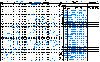 Portion of transect data sheet. Portion of transect data sheet.
|
Each plant was identified and logged on a data sheet. The chart below is a reproduction of data sheet 1. There were 17 data sheets for this 50 meter transect. | |||||||||||||||||||||||||||||||||||||||||||||||||||||||||||||||||||||||||||||||||||||||||||||||||||||||||||||||||||||||||||||||||||||||||||||||||||||||||||||||||||||||||||||||||||||||||||||||||||||||||||||||||||||||||||||||||||||||||||||||||||||||||||||||||||||||||||||||||||||||||||||||||||||||||
| The following information is logged for each plant: | ||||||||||||||||||||||||||||||||||||||||||||||||||||||||||||||||||||||||||||||||||||||||||||||||||||||||||||||||||||||||||||||||||||||||||||||||||||||||||||||||||||||||||||||||||||||||||||||||||||||||||||||||||||||||||||||||||||||||||||||||||||||||||||||||||||||||||||||||||||||||||||||||||||||||||
This particular scheme of measuring plant dimensions has caused a problem. I planned to assume an elliptical shape to each plant, and use the dimensions to calculate coverage. However if the major axis of the shape of the plant is significantly different from either the X-Axis or the Y-Axis, my formula will significantly over-estimate the coverage of the plant. Note, for example, the orientation of plant 11 on data sheet 1. It would have been better to measure the length of the longest axis, and then the axis perpundicular to the longest axis. There are three other fields on the data sheet, but they were used for measuring Frasera albomarginata which is not found in this transect. | ||||||||||||||||||||||||||||||||||||||||||||||||||||||||||||||||||||||||||||||||||||||||||||||||||||||||||||||||||||||||||||||||||||||||||||||||||||||||||||||||||||||||||||||||||||||||||||||||||||||||||||||||||||||||||||||||||||||||||||||||||||||||||||||||||||||||||||||||||||||||||||||||||||||||||
| Measuring the transect required about 10 hours, resulting in a average data collection rate of about 25 meters2 per hour. Seventeen data sheets were required. | ||||||||||||||||||||||||||||||||||||||||||||||||||||||||||||||||||||||||||||||||||||||||||||||||||||||||||||||||||||||||||||||||||||||||||||||||||||||||||||||||||||||||||||||||||||||||||||||||||||||||||||||||||||||||||||||||||||||||||||||||||||||||||||||||||||||||||||||||||||||||||||||||||||||||||
| Upon return from the field, the data was entered into a Microsoft Access data base, where it is one of several transects. A SQL query was written to extract the data and calculate area of coverage. I was unable to determine how to write a query to partition the transect into subtransects in Access. There is a partition function in Access. However, the function does not afford the precise control I wanted is establishing subtransect boundaries. Therefore it was necessary to export the query results to Excel, where subtransect positions were calculated. A pivot table was used to calculate absolute frequency by subtransect. The results were combined into a single Excel spreadsheet and then translated into the table described in Results. | ||||||||||||||||||||||||||||||||||||||||||||||||||||||||||||||||||||||||||||||||||||||||||||||||||||||||||||||||||||||||||||||||||||||||||||||||||||||||||||||||||||||||||||||||||||||||||||||||||||||||||||||||||||||||||||||||||||||||||||||||||||||||||||||||||||||||||||||||||||||||||||||||||||||||||
|
|
Results | |||||||||||||||||||||||||||||||||||||||||||||||||||||||||||||||||||||||||||||||||||||||||||||||||||||||||||||||||||||||||||||||||||||||||||||||||||||||||||||||||||||||||||||||||||||||||||||||||||||||||||||||||||||||||||||||||||||||||||||||||||||||||||||||||||||||||||||||||||||||||||||||||||||||||
|
Other articles:
|
This plot was re-measured on June 7-8, 2006, after the Hackberry Complex fire of June 22-25, 2006. The summary statistics are shown in that page on this web site. | |||||||||||||||||||||||||||||||||||||||||||||||||||||||||||||||||||||||||||||||||||||||||||||||||||||||||||||||||||||||||||||||||||||||||||||||||||||||||||||||||||||||||||||||||||||||||||||||||||||||||||||||||||||||||||||||||||||||||||||||||||||||||||||||||||||||||||||||||||||||||||||||||||||||||
| Summary statistics for Transect 5 are as follows: | ||||||||||||||||||||||||||||||||||||||||||||||||||||||||||||||||||||||||||||||||||||||||||||||||||||||||||||||||||||||||||||||||||||||||||||||||||||||||||||||||||||||||||||||||||||||||||||||||||||||||||||||||||||||||||||||||||||||||||||||||||||||||||||||||||||||||||||||||||||||||||||||||||||||||||
| ||||||||||||||||||||||||||||||||||||||||||||||||||||||||||||||||||||||||||||||||||||||||||||||||||||||||||||||||||||||||||||||||||||||||||||||||||||||||||||||||||||||||||||||||||||||||||||||||||||||||||||||||||||||||||||||||||||||||||||||||||||||||||||||||||||||||||||||||||||||||||||||||||||||||||
|
Where:
| ||||||||||||||||||||||||||||||||||||||||||||||||||||||||||||||||||||||||||||||||||||||||||||||||||||||||||||||||||||||||||||||||||||||||||||||||||||||||||||||||||||||||||||||||||||||||||||||||||||||||||||||||||||||||||||||||||||||||||||||||||||||||||||||||||||||||||||||||||||||||||||||||||||||||||
| The density per unit area is 1.43 plants per meter2. Absolute coverage is 140 m2 of the 250 m2 transect, or approximately 56% of the land surface has plant cover. | ||||||||||||||||||||||||||||||||||||||||||||||||||||||||||||||||||||||||||||||||||||||||||||||||||||||||||||||||||||||||||||||||||||||||||||||||||||||||||||||||||||||||||||||||||||||||||||||||||||||||||||||||||||||||||||||||||||||||||||||||||||||||||||||||||||||||||||||||||||||||||||||||||||||||||
| In terms of density, there are more California Buckwheat (Eriogonum fasciculatum) than any other species in this transect. Blackbrush (Coleogyne ramosissima) is the second most numerous species. Purple Sage (Salvia dorrii) is the third most common species. | ||||||||||||||||||||||||||||||||||||||||||||||||||||||||||||||||||||||||||||||||||||||||||||||||||||||||||||||||||||||||||||||||||||||||||||||||||||||||||||||||||||||||||||||||||||||||||||||||||||||||||||||||||||||||||||||||||||||||||||||||||||||||||||||||||||||||||||||||||||||||||||||||||||||||||
| In terms of coverage, Blackbrush (Coleogyne ramosissima) dominates all other species, followed by a second tier of California Buckwheat (Eriogonum fasciculatum), Staghorn Cholla (Opuntia acanthocarpa) and Blue Yucca (Yucca baccata). | ||||||||||||||||||||||||||||||||||||||||||||||||||||||||||||||||||||||||||||||||||||||||||||||||||||||||||||||||||||||||||||||||||||||||||||||||||||||||||||||||||||||||||||||||||||||||||||||||||||||||||||||||||||||||||||||||||||||||||||||||||||||||||||||||||||||||||||||||||||||||||||||||||||||||||
| Five species are found in all 6 subtransects: Blackbrush (Coleogyne ramosissima), California Buckwheat (Eriogonum fasciculatum), Staghorn Cholla (Opuntia acanthocarpa), Blue Yucca (Yucca baccata) and Nevada Ephedra (Ephedra nevadensis). However, nearly half of all Blackbrush (C. ramosissima) occur in the first sub-transect. Despite my best efforts to find a representative area by subjective means, it appears that the transect started in a patch of Blackbrush (C. ramosissima). California Buckwheat (Eriogonum fasciculatum) is more evenly distributed, except in the first sub-transect, probably because it is crowded out by the Blackbrush. Purple Sage (Salvia dorrii) seems to be crowded in the last two of six sub-transects. | ||||||||||||||||||||||||||||||||||||||||||||||||||||||||||||||||||||||||||||||||||||||||||||||||||||||||||||||||||||||||||||||||||||||||||||||||||||||||||||||||||||||||||||||||||||||||||||||||||||||||||||||||||||||||||||||||||||||||||||||||||||||||||||||||||||||||||||||||||||||||||||||||||||||||||
| The vegetation of this transect can be described as: a desert scrub, dominated by Blackbrush (Coleogyne ramosissima) and California Buckwheat (Eriogonum fasciculatum), with significant proportions of Buckhorn Cholla (Opuntia acanthocarpa), Blue Yucca (Yucca baccata), Purple Sage (Salvia dorrii), Ephedra nevadensis, Turpentine Broom (Thamnosma montana) and Linear Leaved Goldenbush (Ericameria linearifolius). | ||||||||||||||||||||||||||||||||||||||||||||||||||||||||||||||||||||||||||||||||||||||||||||||||||||||||||||||||||||||||||||||||||||||||||||||||||||||||||||||||||||||||||||||||||||||||||||||||||||||||||||||||||||||||||||||||||||||||||||||||||||||||||||||||||||||||||||||||||||||||||||||||||||||||||
| Three species are less common. Bladder Sage (Salazaria mexicana) which I associate with lower elevation washes is found occasionally in this scrub. In the present transect, 11 of 13 individuals were found in the same subtransect. I also associate Catclaw (Acacia greggii) and Desert Almond (Prunus fasciculata) with washes in this immediate area. However, these species are found on hill slopes in other areas, especially where the rock type is Precambrian schist and gneiss. | ||||||||||||||||||||||||||||||||||||||||||||||||||||||||||||||||||||||||||||||||||||||||||||||||||||||||||||||||||||||||||||||||||||||||||||||||||||||||||||||||||||||||||||||||||||||||||||||||||||||||||||||||||||||||||||||||||||||||||||||||||||||||||||||||||||||||||||||||||||||||||||||||||||||||||
| Utah Juniper (Juniperus osteosperma) is found scattered throughout the desert scrub but never dominant here. Its common associate Pinyon Pine (Pinus monophylla) is found on adjacent hill slopes but not within the transect. | ||||||||||||||||||||||||||||||||||||||||||||||||||||||||||||||||||||||||||||||||||||||||||||||||||||||||||||||||||||||||||||||||||||||||||||||||||||||||||||||||||||||||||||||||||||||||||||||||||||||||||||||||||||||||||||||||||||||||||||||||||||||||||||||||||||||||||||||||||||||||||||||||||||||||||
|
Gutierrezia microcephala is poorly represented in this transect
although common in other transects in nearby areas.
An analysis of this transect in relation to other transects and regional vegetation patterns will be made in the parent document. | ||||||||||||||||||||||||||||||||||||||||||||||||||||||||||||||||||||||||||||||||||||||||||||||||||||||||||||||||||||||||||||||||||||||||||||||||||||||||||||||||||||||||||||||||||||||||||||||||||||||||||||||||||||||||||||||||||||||||||||||||||||||||||||||||||||||||||||||||||||||||||||||||||||||||||
| If you have a question or a comment you may write to me at: tomas@schweich.com I sometimes post interesting questions in my FAQ, but I never disclose your full name or address. |
Date and time this article was prepared: 3/23/2025 6:08:48 PM |
|||||||||||||||||||||||||||||||||||||||||||||||||||||||||||||||||||||||||||||||||||||||||||||||||||||||||||||||||||||||||||||||||||||||||||||||||||||||||||||||||||||||||||||||||||||||||||||||||||||||||||||||||||||||||||||||||||||||||||||||||||||||||||||||||||||||||||||||||||||||||||||||||||||||||