Eastern Mojave Vegetation
Tom Schweich
|
Eastern Mojave Vegetation
| US Highway 34 |
|
Tom Schweich |

|
From Granby to Berwyn, with opportunity for hifalutin' hijinks the whole way. | |||||||||||||||||||||||||||||||||||||||||||||||||||||||||||||||||||||||||||||||||||||||||||||
|
Other articles:
|
GranbyJunction: US Highway 40, east to Granby and Denver, west to Hot Sulphur Springs and Steamboat Springs. | |||||||||||||||||||||||||||||||||||||||||||||||||||||||||||||||||||||||||||||||||||||||||||||
|
Other articles:
|
Junction: County Road 40,, west to Willow Creek Reservoir. | |||||||||||||||||||||||||||||||||||||||||||||||||||||||||||||||||||||||||||||||||||||||||||||
|
Other articles:
Locations: Willow Creek Pump Canal. |
Cross Willow Creek Canal. | |||||||||||||||||||||||||||||||||||||||||||||||||||||||||||||||||||||||||||||||||||||||||||||
|
Locations: Table Mountain. |
Highway skirts Table Mountain (to the west) along the shore of Lake Granby. | |||||||||||||||||||||||||||||||||||||||||||||||||||||||||||||||||||||||||||||||||||||||||||||
|
Other articles:
Locations: Lake Granby. |
Lake Granby | |||||||||||||||||||||||||||||||||||||||||||||||||||||||||||||||||||||||||||||||||||||||||||||
|
Other articles:
Locations: Granby Pump Canal. |
Granby Pump Canal beside the Highway. | |||||||||||||||||||||||||||||||||||||||||||||||||||||||||||||||||||||||||||||||||||||||||||||
| Cross Colorado River entering Shadow Mountain Lake. | ||||||||||||||||||||||||||||||||||||||||||||||||||||||||||||||||||||||||||||||||||||||||||||||
|
Other articles:
Locations: Shadow Mountain Lake. |
Shadow Mountain Lake | |||||||||||||||||||||||||||||||||||||||||||||||||||||||||||||||||||||||||||||||||||||||||||||
|
Other articles:
|
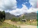
Grand LakeJunction: West Portal Road, Grand Lake and Village | |||||||||||||||||||||||||||||||||||||||||||||||||||||||||||||||||||||||||||||||||||||||||||||
|
Rocky Mountain National Park below | ||||||||||||||||||||||||||||||||||||||||||||||||||||||||||||||||||||||||||||||||||||||||||||||
|
Literature Cited:
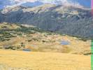
Locations: Kawuneeche Valley. |
Kawuneeche Visitor Center | |||||||||||||||||||||||||||||||||||||||||||||||||||||||||||||||||||||||||||||||||||||||||||||
| Junction: County Road 491 | ||||||||||||||||||||||||||||||||||||||||||||||||||||||||||||||||||||||||||||||||||||||||||||||
| Harbison Meadows Picnic Area | ||||||||||||||||||||||||||||||||||||||||||||||||||||||||||||||||||||||||||||||||||||||||||||||
| Green Mountain Trailhead | ||||||||||||||||||||||||||||||||||||||||||||||||||||||||||||||||||||||||||||||||||||||||||||||
| Onahu Trailhead | ||||||||||||||||||||||||||||||||||||||||||||||||||||||||||||||||||||||||||||||||||||||||||||||
| Coyote Valley Trailhead | ||||||||||||||||||||||||||||||||||||||||||||||||||||||||||||||||||||||||||||||||||||||||||||||
|
Other articles:
Locations:
Colorado River.
|
Bowen-Baker Trailhead | |||||||||||||||||||||||||||||||||||||||||||||||||||||||||||||||||||||||||||||||||||||||||||||
| Holzwarth Historic Site | ||||||||||||||||||||||||||||||||||||||||||||||||||||||||||||||||||||||||||||||||||||||||||||||
| Timber Creek Campground | ||||||||||||||||||||||||||||||||||||||||||||||||||||||||||||||||||||||||||||||||||||||||||||||
| Timber Lake Trailhead | ||||||||||||||||||||||||||||||||||||||||||||||||||||||||||||||||||||||||||||||||||||||||||||||
| Farview Curve | ||||||||||||||||||||||||||||||||||||||||||||||||||||||||||||||||||||||||||||||||||||||||||||||
| Lake Irene | ||||||||||||||||||||||||||||||||||||||||||||||||||||||||||||||||||||||||||||||||||||||||||||||
|
Pacific drainage above
Continental Divide Atlantic drainage below | ||||||||||||||||||||||||||||||||||||||||||||||||||||||||||||||||||||||||||||||||||||||||||||||
| Poudre Lake | ||||||||||||||||||||||||||||||||||||||||||||||||||||||||||||||||||||||||||||||||||||||||||||||
| Alpine Visitor Center | ||||||||||||||||||||||||||||||||||||||||||||||||||||||||||||||||||||||||||||||||||||||||||||||
|
Other articles:
Locations:
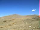
Forest Canyon Pass.
|
Gore Range Overlook | |||||||||||||||||||||||||||||||||||||||||||||||||||||||||||||||||||||||||||||||||||||||||||||
|
Other articles:
|
Tundra Communities Trailhead.Restrooms here. Trailhead: Toll Memorial Trail.
Other articles:
Locations:
Forest Canyon Overlook.
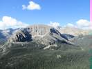
Terra Tomah Mountain.
Other articles:
Other articles:
Locations:
Roaring River.
Other articles:
Locations:
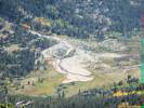
Horseshoe Park.
Other articles:
Other articles:
Locations:
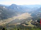
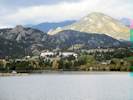
Lake Estes.
Other articles:
This is the big crossroads intersection in Estes Park. Get it right here, as second chances are hard to come by.
Other articles:
Other articles:
Locations:
Greeley.
Other articles:
Other articles:
Date and time this article was prepared:
4/21/2025 8:29:33 PM
|