Eastern Mojave Vegetation
Tom Schweich
|
Eastern Mojave Vegetation
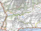
| Alpujarra, Andalucia, Spain |
|
Tom Schweich |

Topics in this Article: Geography Geology Botany History Culture Accomodations Activities Literature Cited |
(No Preface) | ||||||||||||||||||||||||||||||||||||||||||||||||||||||||||||||||||||||||||||||||||||||||||||||||||||||||||||||||||||||||||||||||||||||||||||||||||||||||||||||||||||||||||||||
|
Other articles:
|
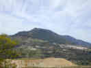
The Alpujarra is the south side of the Sierra Nevada in the south of Spain. This huge mountain range, the second highest in Europe, is separated from the sea by the Sierra de Contraviesa and Sierra de Gador. | ||||||||||||||||||||||||||||||||||||||||||||||||||||||||||||||||||||||||||||||||||||||||||||||||||||||||||||||||||||||||||||||||||||||||||||||||||||||||||||||||||||||||||||||
| The Alpujarra was the last stronghold of the Arabs in Spain. | |||||||||||||||||||||||||||||||||||||||||||||||||||||||||||||||||||||||||||||||||||||||||||||||||||||||||||||||||||||||||||||||||||||||||||||||||||||||||||||||||||||||||||||||
|
|
Geography | ||||||||||||||||||||||||||||||||||||||||||||||||||||||||||||||||||||||||||||||||||||||||||||||||||||||||||||||||||||||||||||||||||||||||||||||||||||||||||||||||||||||||||||||
|
|
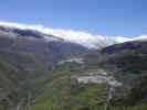
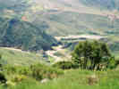
Barranco del Poqueira | ||||||||||||||||||||||||||||||||||||||||||||||||||||||||||||||||||||||||||||||||||||||||||||||||||||||||||||||||||||||||||||||||||||||||||||||||||||||||||||||||||||||||||||||
|
Other articles:
Locations: Barranco del Poqueira. |
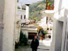
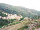
Ravine of the Poqueira, a ravine that runs north from the Rio Guadalfeo into the Sierra Nevada. Pampaneira, Bubión, and Capileira are all found on the east side of the Barranco del Poqueira. | ||||||||||||||||||||||||||||||||||||||||||||||||||||||||||||||||||||||||||||||||||||||||||||||||||||||||||||||||||||||||||||||||||||||||||||||||||||||||||||||||||||||||||||||
|
|
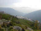
Bubión | ||||||||||||||||||||||||||||||||||||||||||||||||||||||||||||||||||||||||||||||||||||||||||||||||||||||||||||||||||||||||||||||||||||||||||||||||||||||||||||||||||||||||||||||
|
Other articles:
Locations:
Bubión.
Capileira.
Pampaneira.
|
Small town in the Alpujarras, on the east side of Barranco del Poqueira, between Capileira and Pampaneira. | ||||||||||||||||||||||||||||||||||||||||||||||||||||||||||||||||||||||||||||||||||||||||||||||||||||||||||||||||||||||||||||||||||||||||||||||||||||||||||||||||||||||||||||||
If you're in the alpujarras there a great Internet Cafe at Bubión right in the middle of nowhere! From: "Airtel" |
|
| Capileira
|
Other articles:
Locations:
Bubión.
Capileira.
Highest town on the east side of Barranco del Poqueira; north of, and above, Bubión.
|
|
Other articles:
Locations: Embalse de Beninar.
| Embalse de Beninar
|
Literature Cited:
"Entering the Alpujarra from the south, we passed the half deserted villages of Darrical and Lucainena, rotting above a leaky dam which destroyed their fields (Grove and Rackham, 2001)."
|
|
Literature Cited:
Locations: Almería. Campo de Dalías. Rio Grande de Adra.
A desperate attempt has been made to get more water from a dam at Benínar on the Rio Adra, which flows out of the central Alpujarra. The river was supposed to discharge 35 M cu. M annually, of which 13 M were to be diverted to Almería city and 12 M to the Campo de Dalías, leaving 10 M for users in the Adra delta. Prognostications were made of the effect on the salt content of springs and aquifers below the dam. However, the reservoir sits on leaky limestone, and by 1994 it had never filled (Grove and Rackham, 2001).
|
|
Locations: Huécija.
| Huécija
|
Locations: Niguelas.
| Nigüelas
|
"Spent week in Alpujarras village of Nigüelas. Great Bakery. Friendly town, generally. Don't even look at the bar on left on way into town. Very inhospitable landlady. Chiringuita's v. good food. Can recommend the house we rented. But you'll have to email me personally as I don't have details here. | Hill walks from Bubion, Calileira etc for HILL WALKERS. Not suitable for healthy, brisk, panting strolls. Watch out for bees & scorpions. Mind the local drivers. The roads are already dangerous, but the possibility of a car coming round a corner on the wrong side of a hairpin bend makes that 800m drop a little more frightening! Watch out for signs that indicate right of way for narrow bridges. Autovias quite stressful at night - poor lighting - great during the day. Caratierras pleasant too. Avoid having to travel anything else - (whites & yellows on my Michelin Map) - not worth the risk to life & limb (Ken McGowan, Sep 18, 2000)."
|
Locations: Ohanes.
| Ohanes
|
Locations: Rio Andarax.
Small town in the eastern Alpujarra, on the south slope of the Sierra Nevada, north of the Rio Andarax.
|
|
Around the town, the terraces are used for table-grapes or arable crops; and abandoned terraces are heavily grassed. There is a live-oak savanna on the hills above the town.
|
|
Locations: Orgiva.
| Órgiva
|
Alarcon (1892) remarks that the peculiar detached church tower at Orgiva, in which the Christians forted up against the rebels, is shown in exactly its modern location in a town plan of 1572 (Grove and Rackham, 2001).
|
|
Other articles:
Locations: Pampaneira.
| Pampaneira
|
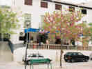
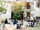 Breakfast in the main plaza of Pampaneira Breakfast in the main plaza of Pampaneira
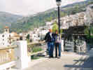 Rachel and Tom with Pampaneira in the background. Rachel and Tom with Pampaneira in the background.
The lowest, and westernmost of, three towns on the Barranco del Poqueira.
|
|
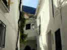 Small street in Pampaneira. Small street in Pampaneira.
 Small street with grape vines overhead. Small street with grape vines overhead.
Asociacion de Artesanos de la Alpujarra C/Veronica S/N - 18411 Pampaneira - Granada Tl. 958784340 Fax 958784326
|
|
Locations: Puerto de la Ragua.
| Puerto de la Ragua
|
The only really good road (A-337) that traverses the Sierra Nevada (farther east, away from Granada) does have one of the highest passes in Spain (Puerto de la Ragua, 2000m)
|
|
Other articles:
Locations: Rio Grande de Adra.
| Rio Grande de AdraAlso simply called Rio Adra, this small river drains the central Alpujarra. It also divides the Sierra de la Contraviesa on the west from the Sierra de Gádor on the east.
|
Locations: Rio Guadalfeo.
| Rio Guadalfeo
|
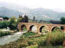 The Rio Guadalfeo near Orgiva. The Rio Guadalfeo near Orgiva.
The Rio Guadalfeo drains the western Alpujarra. It rises in the Sierra Nevada and flows east-west for a distance, separating the Sierra Nevada from the Sierra de la Contraviesa.
|
|
Locations:
Rio Guadalfeo.
|
|
Locations: Salobreña.
| SalobreñaMy father has an exhibition of paintings on at the Sala de Exposiciones de la Biblioteca Municipal in Salobreña on the Granada coast. It'll be on from July 1st to July 12th 2001 inclusive and includes a series of watercolours of the local countryside including the Alpujarras. Roger.
|
Locations: Sierra de la Contraviesa.
| Sierra de la Contraviesa
|
The Sierra de la Contraviesa is a schist range, moderately rugged, with crumbly, poorly developed soils and frequent small springs.
|
|
Literature Cited:
The Sierra de la Contraviesa presents an arid aspect to the coast. Inland, although highly cultivated, it has remains of encina savanna between the almond groves (Grove and Rackham, 2001).
|
|
Locations: Sierra de Gador.
| Sierra de GadorThe easternmost of three mountain ranges on the south side of the Alpujarra. The mountain range on the north side is Sierra Nevada, and the mountain ranges to the west are Sierra de la Contraviesa and Sierra de Lujar.
|
Literature Cited:
The Sierra de Gádor is a range of hard dark dolomitic rocks, with a great north-facing cliff. Cultivation is mostly confined to pockets of metamorphic rocks. The mountain appears very arid, but has ossacional seeps of water. Small aquifers are tapped by water-mines (Grove and Rackham, 2001).
|
|
Literature Cited:
The Sierra de Gádor is part of the Almería desert. Apart from occasional elms by water seeps, the only sign that it has ever had trees are a few live-oaks on a north-facing slope at 1,000 m. (Grove and Rackham, 2001).
|
|
Locations: Sierra de Lujar.
| Sierra de Lujar
|
Locations: Sierra Nevada.
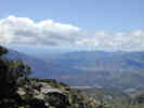
| Sierra NevadaMountain range on the north side of the Alpujarra. Highest mountain range in southern Spain. Part of the Betic System (Sistema Betico).
|
Literature Cited:
The Sierra Nevada is composed of schist, which forms good soils and is not rugged nor very erodable. Water comes out at a strong spring-line along the chain of villages (Grove and Rackham, 2001).
|
|
Other articles:
Locations: Torvizcón.
| Torvizcón
|
 Torvizcon beside its rambla. Torvizcon beside its rambla.
At Torvizcón, there were several places to eat on the highway. Torvizcón is on a rambla (wash) of the same name. We drove through tiny streets until we came to the town square. There was a restaurant there, but no parking places. We parked back down by the rambla, and walked a block back to the town square. The plaza had some trees that I'm sure were Cercis (Redbud). The flowers were a little larger than our redbud, but the leaves were very, very similar.
|
|
 Judas tree (Cercis siliquastrum L.) tree in front of bar where we had lunch. Judas tree (Cercis siliquastrum L.) tree in front of bar where we had lunch.
The restaurant had no menu, but the waitress simply asked whether we wanted fish or meat. Unable to choose, we chose one of each. The fish was some sort of deep-fried fish, and the meat was maybe pork shoulder sliced very thin, and served between two pieces of bread. Each came with several slices of very good ripe tomato. We asked for a second helping of both. This time the fish was more like swordfish, sliced very thin and fried, whereas the pork was very similar to bacon.
|
|
Locations: Trevelez.
| Treveléz
|
Rainfall in the Alpujarra is greatest in the Treveléz area, diminishing eastwards, downwards, and towards the sea.
|
|
The highest permanent settlement in Spain is supposed to be Treveléz in the Alpujarras at 1476 metres above sea level. Since you mention a higher settlement there is obviously some dispute about what constitutes a "settlement". Or maybe it's the "permanent" bit that gives it the distinction. | They certainly make a meal of this claim to fame in Trevelez with many souvenirs proudly displaying messages such as "El pueblo más alto de España". (Their second claim to fame are the splendid serrano hams they produce here.) The drive up to this village is quite an ordeal, up the narrow, windy roads and any visit to the Alpujarras is certainly worthwhile. (Roger Warwick)
|
Locations: Ugíjar.
| Ugíjar
|
| Valle de Lecrín
|
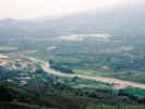 Rio Guadalfeo with Orgiva in background. Rio Guadalfeo with Orgiva in background.
The Lecrin Valley (meaning the Vale of Happiness in Arabic) is situated between Granada and Motril, extending east past Orgiva, in the foothills of the Alpujarras.
|
|
Locations:
Valle de Lecrín.
Taken from Loma de las Palominicas, this view shows Orgiva in the southeastern end of Valle de Lecrín. The Mediterranean is the patch of blue seen through the gap in the mountains.
|
|
Locations:
Valle de Lecrín.
This photograph looks west across the main highway (N323) between Granada and Motril.
|
|
| Geology
|
|
|
| Botany
|
Literature Cited:
Books that cover botany of the Alpujarra include Polunin and Huxley (1966), Lippert and Podlech (n.d.), and Stocken (1969). A little larger in scope is Grove and Rackham (2001).
|
|
| Bryophytes
|
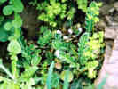
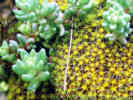 A bryophyte and a succulent growing together. A bryophyte and a succulent growing together.
|
|
| Ferns
|
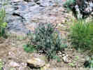
 Fern along trail in Barranco del Poqueira Fern along trail in Barranco del Poqueira
|
|
 Fern in Barranco del Poqueiro Fern in Barranco del Poqueiro
|
|
| Liliaceae
|
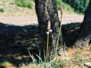 Asphodelus Asphodelus
|
|
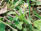
| Ranunculuaceae
|
 Ranunculus along trail in Barranco del Poqueira Ranunculus along trail in Barranco del Poqueira
Ranunculus along trail in Barranco del Poqueira.
|
|
| Crassulaceae
|
A bryophyte and a succulent growing together.
|
|
| Geraniaceae
|
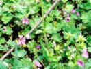 Cranesbill (Erodium sp.) in Barranco del Poqueira. Cranesbill (Erodium sp.) in Barranco del Poqueira.
|
|
| Euphorbiaceae
|
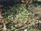
 Spurge(?) along trail in Barranco del Poqueira Spurge(?) along trail in Barranco del Poqueira
Unknown spurge along side trail in Barranco del Poqueira.
|
|
| Cistaceae
|
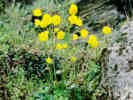
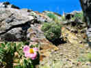 Cistus albidus on Loma de las Palominicas Cistus albidus on Loma de las Palominicas
|
|
| Violaceae
|
 Viola (?) along trail in Barranco del Poqueira Viola (?) along trail in Barranco del Poqueira
Viola (?) along side trail in Barranco del Poqueira.
|
|
| Lamiaceae
|
 Lavender on Loma de las Palominicas Lavender on Loma de las Palominicas
|
|
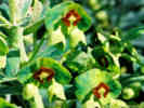
| Campanulaceae
|
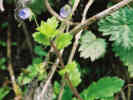 Campanulaceae (?) in Barranco del Poqueira Campanulaceae (?) in Barranco del Poqueira
I really don't have a clue about this one, but I'm thinking in terms of Campanulaceae.
|
|
| History
|
| Culture
|
| Accomodations
|
Check out the following website for houses/villas for rent ...
|
|
Locations: Bubión.
| Hostal Las Terrazas
|
| Activities
|
A good source for information about Las Alpujarras is:
AlpujarraConect - Gateway to Las Alpujarras
|
|
From: Karen Walther | For anyone who is interested in a moderately adventurous 7 day stroll through the Alpujarra mountains, I wanted to post information about a tour offered by Adventure Bug. My friend and I are signed up to go on this tour from August 26 - September 2, at a reasonable price of under $600 US. As of late, we are the only two ones to sign up for the trip! We have been given assurances that it will not be cancelled, however, we would love more company to join us. We have been very impressed by Adventure Bug's website (www.adventurebug.com) and the responsiveness of the founder, Matt Butler.
|
"... we headed for the fast roads thru Granada and onto the turnoff for Lanjaron and the Alpujarras. Once off the motorway we were yet again treated to an incredibly scenic drive as we wound our way up the mountains and into the head of the Poqueira gorge to the little town of Bubion. Upon arrival, we liked the place so much we decided to stay 3 nights at the Hostal Las Terrazas (3,900/nt). The couple running the hostal were incredibly helpful and friendly with lots of suggestions for things to do. We also stopped at Rustic Blue's office and they were very forthcoming with hiking information (Deborah Askew, 01-Jul-01)."
|
|
Locations: Capileira.
The next day we drove up to Capileira and beyond on a dirt road to the Sierra Nevada park boundary. At 9:30am we caught the first bus (800esp/person) and not only did we get a ride high up into the Sierra Nevada but also our own private tour guide as we were the only ones on the bus. The guide did not speak english but he did speak
french so I dug deep into the recesses of my brain and we both stumbled thru in our second languages. From the bus drop off point, it took 2.5 hours to hike up to the top of Mulhacen Peak, the highest peak in mainland Spain. I had read and heard that the hike was unesthetic but we both found it very beautiful as there were lots of wildflowers and we saw over 40 ibex along the way. Haze restricted our view somewhat from the summit but the views were still outstanding. Deborah Askew, 01-Jul-01.
|
|
The last day in Bubion we did a Berber village walk and hiked thru Capilleria, Pitres, Ferreirola, Busquitar & Portugos. The trail was difficult to find in spots and it was an extremely hot day but fortunately we were able to find cerveza stops to keep us refreshed along the way. From Portugos we took the bus (110esp/person) back to Bubion. As there was only one restaurant open in Bubion, we ate the 3 nights 2 km up the road in Capileira and had wonderful food at 3 different places. Deborah Askew, 01-Jul-01.
|
|
| Literature CitedA list of all literature cited by this web site can be found in the Bibliography. |
Grove, A. T., and Oliver Rackham. 2001.
The Nature of Mediterranean Europe: An Ecological History.
New Haven, CT: Yale University Press, 2001.
| |
Lippert, Wolfgang, and Dieter Podlech. n.d..
Plantas del Mediterráneo.
La Coruña, ES: Editorial Everest, S. A..
| |
Polunin, Oleg and Anthony Huxley. 1966.
Flowers of the Mediterranean.
Boston, MA: Houghton Mifflin Company.
| |
Stocken, Lt. Cdr. C. M., D.S.C., RN. 1969.
Andalusian Flowers and Countryside.
Thurlestone, Devon, UK: Mrs. E. M. Stocken., 1969.
|
If you have a question or a comment you may write to me at:
tomas@schweich.com
I sometimes post interesting questions in my FAQ, but I never disclose your full name or address.
|
|
Date and time this article was prepared: 3/23/2025 5:53:17 PM |