Eastern Mojave Vegetation
Tom Schweich
|
Eastern Mojave Vegetation
| California Highway 46 |
|
Tom Schweich |

|
California Highway 46 runs from US Highway 99 near Bakersfield, west across the San Joaquin Valley, sharing part of its route with California Highway 41, to Paso Robles, and then to California Highway 1, just south of Cambria. |
|
Other articles:
|
Junction: California Highway 99, north to Fresno, or south to Bakersfield. |
|
Literature Cited:
Locations: Wasco. |
Wasco |
|
Other articles:
|
Junction: US Interstate 5, north to San Francisco, and south to Los Angeles. |
|
|
Lost Hills |
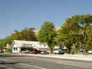
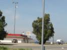 Blackwells Corners, "World's Largest Parking Lot" Blackwells Corners, "World's Largest Parking Lot"
|
|
|
Other articles:
|
Blackwells CornersBlackwells Corners |
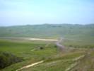
| Polonio Pass | |
|
Locations:
Cholame Valley.
|
|
|
Other articles:
|
Junction: Cholame Valley Road, south to wherever |
|
Other articles:
|
Junction: Cholame Valley Road, north to Parkfield. |
|
Other articles:
|
Junction: California Highway 41, east to Fresno. |
|
Other articles:
Locations:
Cholame.
|
Cholame |
|
Other articles:
|
Junction: California Highway 41, west to Atascadero. |
|
Paso Robles below | |
|
Other articles:
|
Junction: River Road |
| Salinas River Bridge | |
|
Other articles:
|
Junction: US Highway 101, North
This junction is at 24th Street in Paso Robles. California Highway 46 follows the route of US Highway 101 south to the exit west just south of Paso Robles. |
|
Other articles:
Locations: Paso Robles. |
Paso Robles |
|
Locations:
Paso Robles.
|
|
|
Paso Robles above
| |
|
Other articles:
|
Junction: US Highway 101, South through Atascadero to San Luis Obispo and Los Angeles. |
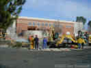
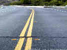 Earthquake cracks on California Highway 46. Earthquake cracks on California Highway 46.
|
|
|
Other articles:
|
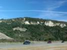
We stopped along California Highway 46 for a view of Morro Rock and Morro Bay. But the winter sun was against us, and the photo very difficult. On the opposite side of the highway, the winter sun was lighting up this fault scarp that places Franciscan Formation above some Miocene sediments. |
|
Other articles:
|
Junction: California Highway 1, north to Cambria, Big Sur, and Monterey, south to Morro Bay and San Luis Obispo. |
| If you have a question or a comment you may write to me at: tas4@schweich.com I sometimes post interesting questions in my FAQ, but I never disclose your full name or address. |
Date and time this article was prepared: 4/27/2024 3:15:39 PM |