|
Other articles:
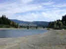
• WA SR 20:
at US 101;
|
Junction: Washington Highway 20
|
Other articles:
• 1st St:
at Golf Course;
• Front Street:
at Golf Course;
|
Junction: E. Front Street and 1st Street
| |
Other articles:
• Hurricane Ridge Road:
at Mt Angeles Rd;
|
Intersection: Race Street, to Mount Angeles Road and Hurricane Ridge Road
| |
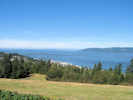
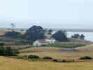
Locations:
Port Angeles.
|
Port Angeles
Intersection: Lincoln Street, US Hwy 101 turns south, continue straight for the Victoria BC — Port Angeles, WA Ferry.
| |
|
| |
Other articles:
• 2nd St:
at Lincoln;
|
Intersection: 2nd Street,
| |
|
Intersection: E. Lauridsen Blvd.
| |
|
Junction: Washington Highway 117 “S Tumwater Truck Route”, also into downtown Port Angeles.
| |
|
Washington above
Oregon below
| |
Other articles:
• Field Notes:
18 Sep 2009;
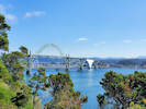
 Astoria-Megler Bridge across Columbia River at Astoria, Oregon. Astoria-Megler Bridge across Columbia River at Astoria, Oregon.
|
| |
|
Port of Astoria
| |
Other articles:
• US Hwy 30:
at US Hwy 101;
|
Junction: US Highway 30, "W. Marine Drive," and "Columbia River Highway" US Highway 101 circles around and climbs toward the Astoria-Megler Bridge without actually entering the town of Astoria.
| |
Other articles:
• Oregon Hwy 104:
at US Hwy 101;
|
Junction: Oregon Highway 104, to Fort Stevens, and Fort Stevens State Park.
| |
|
Seaside
| |
Other articles:
• US Hwy 26:
at US Hwy 101;
|
Junction: US Highway 26
| |
|
Cannon Beach
| |
|
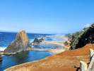
Haystack Rock
Haystack Rock is a 235-foot (72-meter) tall monolith (or sea stack) on the Oregon coast in the northwestern United States, the third-tallest such "intertidal" meaning it can be reached by land, structure in the world. A popular tourist destination, the rock is adjacent to the beach and accessible by foot during low tide. Haystack Rock tide pools are home to many intertidal animals, including starfish, anemone, crabs, chitons, limpets, and sea slugs. The rock is also a refuge for many sea birds, including terns and puffins.
Composed of basalt, Haystack Rock was formed by lava flows emanating from the Grand Ronde Mountains 10 to 17 million years ago.
| |
Other articles:
• Field Notes:
17 Sep 2009;
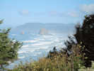 Haystack Rock, off Cannon Beach, Oregon Haystack Rock, off Cannon Beach, Oregon
|
View Point
| |
Other articles:
• Field Notes:
17 Sep 2009;
 Life Jacket Loaner Station, Nehalem Bay, Oregon Life Jacket Loaner Station, Nehalem Bay, Oregon
 Nehalem Bay, Oregon Nehalem Bay, Oregon
|
Nehalem Bay State Park
| |
|
Nehalem
| |
|
Garibaldi
| |
|
Tillamook
| |
|
Hebo
Hebo
| |
Other articles:
• Field Notes:
30 Sep 2022;
Locations:
Yaquina Head.
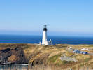 Yaquina Head Lighthouse. Yaquina Head Lighthouse.
|
Yaquina Head
| |
Other articles:
• U. S. Highway 20:
Newport;
Locations:
Newport.
|
Newport
Junction: US Highway 20
| |
Other articles:
• Field Notes:
30 Sep 2022;
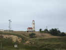
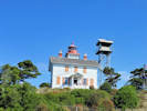 Yaquina Bay Lighthouse. Yaquina Bay Lighthouse.
|
Yaquina Bay Lighthouse
|
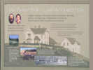
OREGON HISTORY
|
|
YAQUINA BAY
|
|
The old Yaquina Bay lighthouse established in 1871 is the earliest aid to navigation, standing within the range of the first recorded landfall made from a ship to the shores of the Pacific Northwest.
Captain James Cook made this landfall in March 7, 1778
at noon
He named Cape Foul-Weather.
On account of the heavy weather he was compelled to stand out to sea at night and only approach the land in the afternoon so that he was unable to find any harbor along the Oregon coast.
News of Cook's voyage to the Pacific Northwest stimulated the American interests in this region and aroused in Thomas Jefferson and interest that led to the Louisiana Purchase in 1803 and the dispatch of the Lewis and Clark expedition.
|
| |
Other articles:
• Field Notes:
30 Sep 2022;
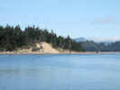
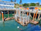 Sea Lions in Yaquina Bay. Sea Lions in Yaquina Bay.
 Yaquina Bay, with a few sea lions on the rocks. Yaquina Bay, with a few sea lions on the rocks.
|
Yaquina Bay
| |
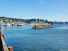
Other articles:
• Field Notes:
30 Sep 2022;
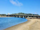
 Yaquina Bay Bridge Yaquina Bay Bridge
|
Yaquina Bay Bridge
| |
Literature Cited:
- Centala, Maxine, 2013.
Other articles:
• Field Notes:
30 Sep 2022;
Locations:
Seal Rock.
|
Seal Rock State Wayside
Seal Rocks, view to the north. |
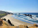
Seal Rocks, view to the south. |
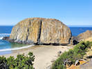
Seal Rock, a basalt flow resting on Pliocene beach deposits. |
| |
|
Alsea Bay Bridge
| |
Other articles:
• Field Notes:
30 Sep 2022;
 Alsea Bay Bridge in Waldport. Alsea Bay Bridge in Waldport.
|
Alsea Bay Historic Interpretive Center
| |
Locations:
Waldport.
|
Waldport
Junction: Oregon Highway 34 “Northeast Alsea Highway”
|
Other articles:
• Field Notes:
15 Sep 2022;
29 Sep 2022;
in Yachats;
Locations:
Yachats.
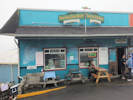 Late lunch/early dinner at the Luna Sea Fish House (2022). Late lunch/early dinner at the Luna Sea Fish House (2022).
|
Yachats
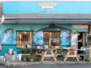
Luna Sea Restaurant, Yachats, Oregon (2009). |
| |
Other articles:
• Field Notes:
on Cape Perpetua;
Locations:
Cape Perpetua.
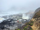
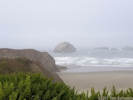
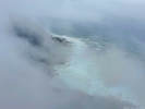 Waves and rocks through the fog. Waves and rocks through the fog.
|
Cape Perpetua
| |
|
Devil's Churn Observation Site
| |
|
Junction: Forest Road 5553, to campground and top of Cape Petpetua.
| |
Other articles:
• Field Notes:
15 Sep 2022;
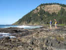 Tide pools at Cape Perpetua, Oregon Tide pools at Cape Perpetua, Oregon
|
Cape Perpetua Interpretive Center
| |
Other articles:
• Field Notes:
on Cape Perpetua;
 Waiting for the perfect shot at the Captain Cook Trailhead. Waiting for the perfect shot at the Captain Cook Trailhead.
|
Cape Cove and Captain Cook Trailhead
| |
|
Heceta Head Lighthouse
| |
Other articles:
• Field Notes:
15 Sep 2022;
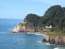 Heceta Head Lighthouse from view point. Heceta Head Lighthouse from view point.
|
Viewpoint for Heceta Head Lighthouse.
| |
|
Sea Lion Caves
| |
Other articles:
• Field Notes:
15 Sep 2022;
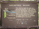 Interpretive sign for Darlingtonia State Wayside Interpretive sign for Darlingtonia State Wayside
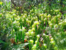 Darlingtonia californica Darlingtonia californica
|
Darlingtonia State Wayside
| |
|
Florence
| |
Other articles:
• Oregon Highway 126:
near Florence;
|
Junction: Oregon Highway 126, east to Eugene, Redmond, and Prineville.
| |
Other articles:
• Field Notes:
15 Sep 2022;
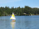 Sailboat on Woahink Lake Sailboat on Woahink Lake
|
Jessie M. Honeyman State Park and Woahink Lake.
| |
Other articles:
• Field Notes:
February 1969;
Locations:
Siltcoos Lake.
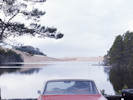 Picnic lunch in the rain at Siltcoos Lake. Picnic lunch in the rain at Siltcoos Lake.
|
Siltcoos Lake

Picnic in the car. |
| |
|
Reedsport
| |
Other articles:
• Field Notes:
15 Sep 2022;
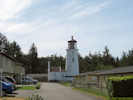 Umpqua Lighthouse, Oregon Umpqua Lighthouse, Oregon
 Lighthouse keeper's quarters, Umpqua Lighthouse, Oregon. Lighthouse keeper's quarters, Umpqua Lighthouse, Oregon.
|
Umpqua Lighthouse State Park
| |
Other articles:
• Field Notes:
15 Sep 2022;
 Mouth of Umpqua River, Oregon Mouth of Umpqua River, Oregon
|
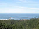
Viewpoint of mouth of Umpqua River.
| |
Other articles:
• Newmark St:
at US Hwy 101;
|
Junction: Newmark Street, to state parks. The hill is pretty steep at this end of Newmark St. If I had a big rig, I would use a more gentle route, to be found either to the north or the south.
| |
|
Coos Bay
| |
|
Junction: West Beaver Hill Road, back road to state parks.
| |
|
Junction: Seven Devils Road
| |
Other articles:
• Field Notes:
17 Oct 2017;
Locations:
Bandon.
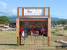
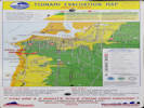 Tsunami Evacuation Map for Bandon, Oregon Tsunami Evacuation Map for Bandon, Oregon
|
Bandon
Face Rock |
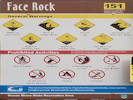
Location code for use in case of emergency |
| |
Other articles:
• Field Notes:
14 Sep 2009;
 Ellen Warring Learning Center at New River ACEC Ellen Warring Learning Center at New River ACEC
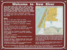 Information about New River ACEC Information about New River ACEC
|
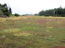
Cranberry bogs along Croft Lake Road. |
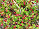
Cranberries along Croft Lake Road. |
Junction: Croft Lake Road, to New River ACEC, and a place to view cranberry bogs.
New River is a dynamic, ever-changing system influenced by biological, climatological, geo-physical, and fluvial processes. The river and adjacent lands administered by the Bureau of Land Management (BLM) are in a special management category known as the New River Area of Critical Environmental Concern (ACEC). The New River ACEC is managed to maintain biodiversity and quality habitats for native communities of plants, birds, animals, and fish. It also provides protection to cultural sites and affords educational, interpretive, and recreational opportunities to the visiting public in a manner consistent with the primary goals of protecting natural and cultural resources.
BLMs vision of the New River area includes protecting or enhancing habitats for a diversity of wildlife and plant species. Varied ecosystems such as meadows, forests, wetlands, coastal lakes, open sand dunes, and the New River estuary will continue to support this biodiversity. This includes a more stable meandering river with greater riparian vegetation. BLM also envisions a visiting public that will appreciate and enjoy the varied ecosystems protected at New River in a way that will not degrade the naturalness of the setting or the quality of the visitor experience. BLM will manage the ACEC primarily for non-motorized public use that is compatible with the semi-primitive natural setting evident throughout most of the area.
In 1983, BLM designated 686 acres of federal lands along New River as an Area of Critical Environmental Concern (ACEC) to protect this unique natural area. In 1989, a land acquisition plan was completed, and over the next eight years, BLM acquired an additional 670 acres of private lands from willing sellers, bringing the current total land base of the ACEC to 1,356 acres.
The primary resource values for the New River ACEC include:
- River area and uplands contain important habitat for the American and Arctic Peregrine Falcon, Bald Eagle, Aleutian Canada Goose, and Western Snowy Plover all federally listed species.
- Botanical species habitat supported in the New River area include silvery phacelia, western bog lily, pink sand-verbena all federally proposed or candidate species.
- Plant Communities Includes natural meadows, wetlands, sand dunes, and other habitat types supporting many unique plant species.
- Wildlife Habitat Upland areas provide supporting habitat types and act as a buffer which supports the integrity of the river habitat areas.
- Historic/Cultural Numerous, extensive prehistoric camps and villages border the river.
| |
|
Langlois
| |
Other articles:
• Field Notes:
14 Sep 2009;
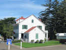
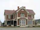 Hughes House Hughes House
 Plaque for Hughes House Plaque for Hughes House
|
Cape Blanco Lighthouse |
Junction: Cape Blanco Road, west to Cape Blanco Lighthouse, and Hughes House.
| |
|
Port Orford
| |
|
Gold Beach
| |
|
Brookings
| |
|
Oregon above ..
California below
| |
|
Crescent City
| |
|
Prairie Creek Redwoods State Park
| |
Other articles:
• Bald Hills Road:
at US 101;
|
Junction: Bald Hills Road, to Lady Bird Johnson Grove, and eventually to California Highway 169 at Martins Ferry.
| |
|
Orick
| |
|
Trinidad
| |
Other articles:
• California Highway 299:
at US 101;
|
Junction: California Highway 299, east through Redding to Alturas and beyond.
| |
Locations:
Arcata.
|
Arcata
| |
Locations:
Eureka.
|
Eureka
|
 Southport Landing Bed and Breakfast Southport Landing Bed and Breakfast
|
This was one of the best bed and breakfast experiences I've had.
| |
Locations:
Loleta.
|
Loleta
Loleta is a small town by the side of US Highway 101.
| |
Locations:
Loleta.
 Loleta Cheese Company Loleta Cheese Company
|
The Loleta Cheese Factory is a interesting one-hour stop to watch the cheese being made.
| |
Other articles:
• California Highway 36:
at US Hwy101;
|
Alton
Junction: California Highway 36, east to Susanville.
| |
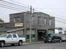
Locations:
Scotia.
|
Scotia
Lumber town in northern California, owned by Pacific Lumber Company.
|
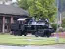 Heisler locomotive at the Scotia Museum. Heisler locomotive at the Scotia Museum.
|
Heisler geared locomotive at the Scotia Museum.
|
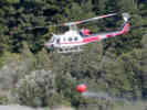 Helicopter takes water from the Eel River Helicopter takes water from the Eel River
|
CDF helicopter takes off from the Eel River with water to dump on a small fire.
| |
Locations:
Eel River.
 Eel River at Dyerville (site) Eel River at Dyerville (site)
|
The railroad bridge at Dyerville.
| |
|
Dyerville (Site)
The former site of Dyerville is on a bluff on the west side of the confluence of the North and South Forks of the Eel River. Across the river, to the south, is Founders Grove of Humboldt Redwoods State Park.
| |
Other articles:
• California Highway 1:
at US Highway 101;
Locations:
Leggett.
|
Leggett
Junction: California Highway 1, a twisty road that follows the California coast all the way to San Juan Capistrano.
| |
Other articles:
• Branscomb Road:
at US Hwy 101;
 Branscomb Road in Laytonville, California Branscomb Road in Laytonville, California
|
Junction: Branscomb Road, west to CA Highway 1 at the Pacific Ocean.
| |
|
Laytonville
| |
|
Willits
| |
Other articles:
• California Highway 20:
in Willits;
|
Junction: California Highway 20, west to Fort Bragg.
| |
Other articles:
• California Highway 20:
near Calpella;
|
Junction: California Highway 20
| |
|
Calpella
| |
|
Junction: Redwood Highway to California Highway 128, west through the Anderson Valley, and Boonville, to the California coast just south of Mendocino.
| |
|
Cloverdale
| |
Other articles:
• California Highway 128:
at USHwy101;
|
Junction: California Highway 128, on the south end of Cloverdale.
| |
Literature Cited:
- Wakabayashi, John, Arundhuti Ghatak, and Asish R. Basu, 2010.
Locations:
Healdsburg.
|
Healdsburg
Location of a high-grade metamorphic block of Franciscan Formation, sampled by Wakabayashi et al. (2010).
| |
Literature Cited:
- Wakabayashi, John, Arundhuti Ghatak, and Asish R. Basu, 2010.
Locations:
Mill Creek.
|
Junction: Mill Street, Westside Road, accessible from north only, use Healdsburg Avenue if coming from south.
Along Mill Creek Road is a Wakabayashi et al. (2010) sample locality for a high-grade metamorphic block of Franciscan Formation.
| |
Literature Cited:
- Wakabayashi, John, Arundhuti Ghatak, and Asish R. Basu, 2010.
Locations:
Terra Linda.
|
Terra Linda
| |
Other articles:
• US Interstate 580:
01000;
|
Junction: U. S. Interstate 580, west across the Richmond-San Rafael Bridge, to Oakland, and Interstate 5 in the San Joaquin Valley.
| |
Other articles:
• Sir Francis Drake Boulevard:
88000;
|
Junction: Sir Francis Drake Blvd, west to Point Reyes.
| |
Other articles:
• California Highway 1:
Mill Valley;
Locations:
Mill Valley.
|
Mill Valley
Junction: California Highway 1.
| |
Locations:
Golden Gate Bridge.
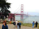 Golden Gate Bridge Golden Gate Bridge
|
Golden Gate Bridge
| |
Other articles:
• California Highway 1:
San Francisco;
|
Junction: California Highway 1, Park Presidio Blvd.
| |
Locations:
San Francisco.
|
San Francisco
| |
Other articles:
• Interstate 80:
12000;
|
Junction: U. S. Interstate 80.
| |
Other articles:
• US I-280:
at US Hwy 101;
|
Junction: US Interstate 280
| |
Locations:
San Bruno Mountain.
 San Bruno Mountain as seen from Alameda. San Bruno Mountain as seen from Alameda.
|
San Bruno Mountain.
| |
Other articles:
• CA Hwy 92:
60000;
|
Junction: California Highway 92, west to Half Moon Bay, or east across the San Mateo Bridge to Hayward.
| |
Other articles:
• CA Hwy 84:
at US 101N;
|
Junction: Woodside Road, California Highway 84.
| |
Other articles:
• CA Hwy 84:
at US 101S;
|
Junction: Marsh Road, California Highway 84
| |
Other articles:
• US I-880:
in San Jose;
|
San Jose
| |
Other articles:
• US I-280:
at US I 680;
• US I-680:
at US Hwy101;
|
Junction:
- US Interstate 280, west through San Jose and then north to San Francisco.
- US Interstate 680, east and north through San Jose to Concord to US I-80 at Cordelia Junction.
| |
Literature Cited:
- Gudde, Erwin G., 1969 (3rd Ed.).
Locations:
Gilroy.
|
Gilroy
John Gilroy, a Scotch sailor and the first permanent non-Spanish settler in California, was left ashore in Monterey in 1814 by the Hudson's Bay vessel Isaac Todd because he was sick with scurvy. He settled in the Santa Clara Valley and married into a Mexican land grant family, whose rancho eventually became called "Gilroy's" (Gudde, 1969, p. 120).
| |
Other articles:
• California Highway 152:
25940;
|
Junction: California Highway 152, east through Pacheco Pass to US Interstate 5 and California Highway 99 in the San Joaquin Valley.
| |
|
DeLorme's Northern California Atlas and Gazetteer above
37° North.
DeLorme's Southern California Atlas and Gazetteer below.
| |
Other articles:
• CA Hwy 25:
at US Hwy 101;
|
Junction: California Highway 25, south to Hollister, then past the east side of Pinnacles National Monument.
| |
|
Junction:
- California Highway 129, west along the Pajaro River, through the Pajaro Valley, and the town of Pajaro, to California Highway 1.
- San Juan Highway, south through the San Juan Valley to San Juan Bautista.
| |
Locations:
Fremont Peak.
San Juan Valley.
 Fremont Peak from San Juan Valley Fremont Peak from San Juan Valley
|
View southeast across the San Juan Valley to Fremont Peak.
| |
Other articles:
• California Highway 156:
10000;
|
Junction: California Highway 156, southeast to San Juan Bautista, and east to Hollister.
| |
Other articles:
• Crazy Horse Canyon Road:
10000;
|
Junction: Crazy Horse Canyon Road, south through Crazy Horse Canyon to San Juan Grade Road and Old Stage Road.
| |
Other articles:
• California Highway 68:
62000;
|
Junction: California Highway 68.
| |
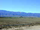
Locations:
Salinas.
 The city of Salinas in the Salinas Valley as seen from Fremont Peak. The city of Salinas in the Salinas Valley as seen from Fremont Peak.
|
Salinas
| |
Other articles:
• Old Stage Road:
90000;
|
Junction:
- Alta Street
- Old Stage Road, vearing north of the highway and east of Salinas, eventually reaching San Juan Bautista.
| |
|
Gonzales
| |
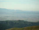
Locations:
Camphora.
 Salinas Valley and the Sierra de Salinas Salinas Valley and the Sierra de Salinas
|
Camphora
| |
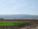
Other articles:
• Field Notes:
11-Nov-05 near Soledad;
Locations:
Salinas Valley.
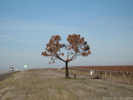
 Farmland near Soledad, Salinas Valley. Farmland near Soledad, Salinas Valley.
|
Junction: Front Street, north end of Soledad.
| |
Other articles:
• Field Notes:
11-Nov-05;
Locations:
Soledad.
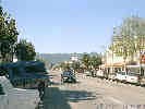
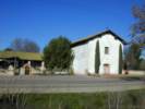
 Front Street in Soledad. Front Street in Soledad.
|
Soledad
| |
Other articles:
• California Highway 146:
at US Hwy 101;
|
Junction: California Highway 146, at the south end of Soledad.
California Highway 146 goes east to Pinnacles National Monument.
| |
Locations:
Salinas River.
|
Salinas River
| |
Other articles:
• Arroyo Seco Road:
at US Hwy 101;
|
Junction: Arroyo Seco Road
|
Other articles:
• El Camino Real:
at US Hwy 101;
|
Junction: El Camino Real, north of Greenfield.
| |
|
Greenfield
| |
Other articles:
• El Camino Real:
at US Hwy 101;
|
Junction: El Camino Real, south of Greenfield.
| |
Other articles:
• County Route G14:
at US Hwy 101;
|
Junction: Jolon Road, County Route G14. Jolon Road roughly parallels US Highway 101 from near King City through the countryside and back to US Highway 101 near Bradley.
| |
Other articles:
• CR G-13:
at US Hwy 101;
Locations:
King City.
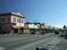
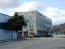
 Broadway Street, the main street of King City. Broadway Street, the main street of King City.
|
King City
| |
Other articles:
• Monterey County Route 15:
at US Hwy 101;
|
Junction: Monterey County Route G15, north through King City and the east side of the Salinas River.
| |
Other articles:
• CA Hwy 198:
at US Hwy 101;
• Lockwood San Lucas Road:
at US Hwy 101;
|
Junction:
- California Highway 198, east to Coalinga, across the San Joaquin Valley and into the Sierra Nevada.
- Lockwood San Lucas Road, west, across the Salinas River, then southwest through the hills to Lockwood.
| |
Other articles:
• Lockwood San Lucas Road:
at US Hwy 101;
|
Junction: Lockwood-San Lucas Road, southwest through the hills to Lockwood.
|
 Dead Monterey Pine with pumpkin. Dead Monterey Pine with pumpkin.
 Whimsical Reindeer Pumpkin beside the highway. Whimsical Reindeer Pumpkin beside the highway.
|
Whimsical pumpkin in a dead Monterey Pine.
| |
Other articles:
• County Route G18:
30000;
|
Junction: Jolon Road, County Route G18
Also known as "Jolon Road," makes a nice alternative to US Highway 101 if you want to get off the highway for a bit. Also, it is the way to Mission San Antonio de Padua.
| |
Other articles:
• Bradley Road:
at US Hwy 101 N;
|
Exit 251: Bradley Road, south to Bradley.
| |
Locations:
Bradley.
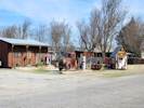 Bradley, California Bradley, California
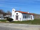 Our Lady of Guadalupe Our Lady of Guadalupe
|
Bradley
Bradley was a small town on the original route of US Highway 101.
| |
|
Southbound Rest Stop
| |
|
Northbound Rest Stop
| |
Other articles:
• Bradley Road:
at US Hwy 101 S;
|
Exit 245: Bradley Road, nouth to Bradley.
| |
Literature Cited:
- Adams, Ella, n.d..
Locations:
McKay.
|
McKay
Name of a (former) Southern Pacific railroad station near Camp Roberts. Junction with a shortline railroad to the Stone Canyon Mine.
| |
Other articles:
• Mission Street:
at US Hwy 101 N;
|
Exit 241: Mission Street, north of San Miguel.
| |
Other articles:
• 10th Street:
at US 101 N;
• Field Notes:
20020120020;
Locations:
San Miguel.
 Mission San Miguel Mission San Miguel
|
San Miguel
Exit 239: 10th Street, for San Miguel.
| |
Other articles:
• Mission Street:
at US 101 S;
|
Exit 239A: Mission Street, south of San Miguel.
| |
|
Paso Robles below
| |
Other articles:
• Spring Street:
at US Highway 101 N;
|
Junction: Spring Street, exit south for main street of Paso Robles.
| |
Other articles:
• California Highway 46:
722000;
• County Route G14:
at US Hwy 101;
|
Junction: California Highway 46, east to Lost Hills, then Wasco and California Highway 99.
| |
Other articles:
• California Highway 46:
Paso Robles;
Locations:
Paso Robles.
|
Paso Robles
| |
Locations:
Paso Robles.
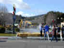
 Rejuvenated Hot Spring After San Simeon Earthquake. Rejuvenated Hot Spring After San Simeon Earthquake.
|
A magnitude 6.5 earthquake struck the central California coast on December 22, 2003 at 11:15:56 am (PST). The event was located 11 km NE of San Simeon, and 39 km WNW of Paso Robles, where the brunt of the damage and casualties occurred. Two deaths occurred due to a building collapse in Paso Robles.
The magnitude 6.5 temblor ruptured a hot springs aquifer and as much as 1,000 gallons per minute of sulfurous water is pouring out of the ground at the City Hall parking lot.
The rupture was caused by the quake because it started the same day. It first appeared as a steaming spring about 4 inches high and 24 inches in diameter in the Paso Robles City Hall Parking lot (P. Rafferty, pers. comm.).
| |
Locations:
Paso Robles.
 Rejuvenated Hot Spring After San Simeon Earthquake. Rejuvenated Hot Spring After San Simeon Earthquake.
|
The warm water has the rotten-egg smell typical of hot springs. State water officials said the sulfurous water does not pose a public health threat but may be harmful to the Salinas River ecosystem. In addition to sulfur, the water could contain other dissolved minerals that could be toxic to fish. The warm temperature of the water may also be harmful. The water was being channeled into the city's storm drain system, which eventually empties into the Salinas River.
| |
Literature Cited:
- Campion, L. F., 1984.
Locations:
Paso Robles.
 A new pump is tried in the rejuvenated hot spring. A new pump is tried in the rejuvenated hot spring.
|
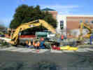
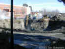
When I first saw the rejuvenated hot spring, Friday, 26 December 2003, a hole about 10 feet deep and 30 feet in diameter had been dug in the parking lot. Various approaches to pumping out the water were being tried. A pump was lowered part way into the pit, but several days later it had been removed. City officials have not figured out a way to stop the flow.
| |
Locations:
Paso Robles.
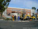
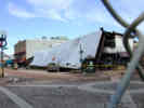 Collapsed roof in downtown Paso Robles. Collapsed roof in downtown Paso Robles.
 Failed brick veneer. Failed brick veneer.
|
The Acorn Building, shown here collapsed, was built in 1892 of unreinforced masonry. It had a third story clock tower that was a highlight of Paso Robles architecture. The two women who perished in this earthquake were killed by falling debris under the collapsing roof.
| |
Locations:
Paso Robles.
 Rejuvenated hot spring after 6 days. Rejuvenated hot spring after 6 days.
|
As reported by David Sneed in the San Luis Obispo Tribune on Tuesday, 30 December 2003, the city is unsure how to plug hot springs flow.
| |
Other articles:
• Spring Street:
at US Hwy 101 South;
|
Junction: Spring Street, exit north for main street of Paso Robles.
| |
|
Paso Robles above
| |
Other articles:
• California Highway 46:
748000;
|
Junction: California Highway 46, west through the Santa Lucia Range to California Highway 1 near Cambria.
| |
Other articles:
• California Highway 41:
Atascadero;
Locations:
Atascadero.
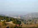 View of Atascadero on a hazy winter afternoon. View of Atascadero on a hazy winter afternoon.
|
Atascadero
| |
Other articles:
• California Highway 58:
Santa Margarita;
Locations:
Santa Margarita.
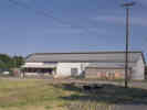 Santa Margarita Feed and Supply Santa Margarita Feed and Supply
|
Santa Margarita
Junction: California Highway 58, east to Bakersfield and then Barstow.
| |
Other articles:
• TV Tower Road:
at US Hwy 101;
Locations:
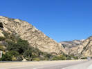
Cuesta Pass.
|
Cuesta Pass
Junction: TV Tower Road, along Cuesta Ridge.
| |
Other articles:
• Field Notes:
18 Apr 1945;
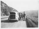 A crew of guys help Peggy Stoddard change a flat, April 18, 1945. A crew of guys help Peggy Stoddard change a flat, April 18, 1945.
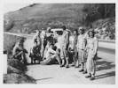 A crew of guys help Peggy Stoddard change a flat, April 18, 1945. A crew of guys help Peggy Stoddard change a flat, April 18, 1945.
|
| |
Other articles:
• California Highway 1:
San Luis Obispo;
Locations:
San Luis Obispo.
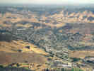 Aerial view of San Luis Obispo. Aerial view of San Luis Obispo.
|
San Luis Obispo
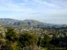
View of San Luis Obispo from Bishop's Peak |
San Luis Obispo was founded as the Mission San Luis Obispo de Tolosa in 1772 by Father Junípero Serra. The mission was named after Saint Louis, a 13th Century Bishop of Toulouse, France. Mission San Luis Obispo de Tolosa was the fifth mission in the California chain of 21 missions along El Camino Real. The closest mission to the south is La Purisima Concepcion, while the closest mission to the north is San Miguel Arcangel.
The City of San Luis Obispo serves as the commercial and cultural hub of Californias Central Coast, as well as being the county seat of San Luis Obispo County. One of Californias oldest communities, the city was was first incorporated in 1856. With a population of 44,000, the City is located eight miles from the Pacific Ocean and is midway between San Francisco and Los Angeles at the junction of Highway 101 and scenic Highway 1. A well-known state university and my alma mater, California Polytechnic State University, is located on the north edge of town.
| |
Other articles:
• Los Osos Valley Road:
at US Hwy 101;
|
Junction: Los Osos Valley Road
| |
Other articles:
• California Highway 1:
Pismo Beach;
Locations:
Pismo Beach.
|
Pismo Beach
Junction: California Highway 1.
| |
Other articles:
• CA Hwy 166:
north of Santa Maria;
|
Junction: California Highway 166, east through the Cuyama Valley to the San Joaquin Valley.
| |
Other articles:
• CA Hwy 166:
in Santa Maria;
• California Highway 176:
at US Hwy 101;
|
Junction:
- California Highway 166, west to Guadalupe.
- California Highway 176, southeast along the Sisquoc River, and then through Foxen Canyon, on the way to Los Olivos.
| |
|
Santa Maria
| |
Other articles:
• California Highway 154:
at US Hwy101;
|
Junction: California Highway 154, for Los Olivos, and the back way to Santa Barbara over San Marcos Pass. Also access to California Highway 176 and Foxen Canyon is accessible via this exit.
| |
Other articles:
• California Highway 1:
Las Cruces;
|
Las Cruces
Junction: California Highway 1, north through Lompoc to Pismo Beach and US Highway 101 again. Also gives access to Jalama Beach.
| |
Literature Cited:
- Follmi, Karl B., Christophe Badertscher, Eric de Kaenel, Peter Stille, Cedric M. John, Thierry Adatte, Philipp Steinmann, 2005.
Locations:
Dos Pueblos Canyon.
|
Bridge over Dos Pueblos Canyon. The beach informally named Naples Beach is at the mouth of this canyon.
Follmi et al. (2005) examined phosphogenesis and organic carbon preservation in the Monterey Formation to revisit the Monterey hypothesis that increased carbon deposition reduced atmospheric carbon and led to cooling of the Earth's climate. Follmi et al. (2005) reject the hypothesis because the rate of carbon deposition was quite modest, among other reasons.
| |
Locations:
Naples.
|
| |
Other articles:
• California Highway 154:
in Santa Barbara;
|
Junction: California Highway 154, San Marcos Pass Road.
| |
Other articles:
• Field Notes:
12 Oct 2017;
 Gaviota Rest Stop Gaviota Rest Stop
|
Gaviota Pass Rest Stop
| |
Locations:
Santa Barbara.
|
Santa Barbara
| |
Other articles:
• California Highway 33:
near Ventura;
|
Junction: California Highway 33, north through Ojai and many other points to Coalinga.
| |
Locations:
Ventura.
|
Ventura
| |
Literature Cited:
- Warrick, Johnathon A., and Patrick L. Barnard, 2012.
Locations:
Santa Clara River.
|
Cross Santa Clara River. Warrick and Barnard (2012) studied sedimentation at the mouths of the San Lorenzo and Santa Clara Rivers after substantial
flood events. They found that the amount of sand delivered to the littoral cells was substantially different between the two
rivers.
| |
Other articles:
• California Highway 1:
Oxnard;
Locations:
Oxnard.
|
Oxnard
Junction: California Highway 1.
| |
Other articles:
• US I-10:
at I-5;
• U. S. Interstate 5:
80000;
|
Junction: Interstate 5, Interstate 10
|
|
If you have a question or a comment you may write to me at:
tas4@schweich.com
I sometimes post interesting questions in my FAQ, but I never disclose your full name or address.
|
[Home Page] [Site Map]
Date and time this article was prepared:
4/27/2024 3:30:04 PM
|
| | |
 Eastern Mojave Vegetation
