Eastern Mojave Vegetation
Tom Schweich
|
Eastern Mojave Vegetation
| California Highway 41 |
|
Tom Schweich |

|
(No Preface) | |
|
Other articles:
|
Crane FlatJunction: California Highway 120, east over Tioga Pass to US Highway 395, or west through Oakdale to Manteca, with connections to the San Francisco Bay Area. | |
|
Other articles:
|
Junction: California Highway 140, , on the Yosemite Valley floor. | |
|
Other articles:
Locations:
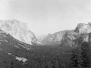
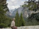
Yosemite National Park.
|
Inspiration Point
| |
|
Other articles:
|
OakhurstJunction: California Highway 49, north through the California Gold Country. | |
|
Other articles:
|
Junction: California Highway 99, north to Sacremento. | |
|
|
Fresno | |
|
Other articles:
|
Junction: California Highway 99, south to Bakersfield. | |
|
Other articles:
|
Kettlemen CityJunction: US Interstate 5, up and down the Great Valley of California. | |
|
Other articles:
|
Junction: Calfiornia Highway 33, north to Coalinga, or south to Ventura. | |
|
Other articles:
|
Junction: CA Highway 46 | |
|
Other articles:
|
Junction: Cholame Valley Road, north to Parkfield. | |
|
Other articles:
|
Junction: Cholame Valley Road, south to wherever | |
|
Other articles:
Locations:
Cholame.
|
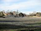
CholameThe actual crash site is a half mile east on highway 46, and 200 yards to the west, in the middle of a farm field. The intersection was realigned when the highway was repaved and renumbered back in 1973. The old intersection and the last 8 miles of the highway that Dean traveled are on land belonging to the State Water Department, and The Jack Ranch, and permission must be obtained to walk or drive the short stretch of old highway. | |
|
Other articles:
|
Junction: CA Highway 46. | |
|
|
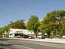
Shandon | |
|
Other articles:
Locations:
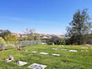
Atascadero Pine Mountain Cemetery.
|
Atascadero Cemetery | |
|
Other articles:
|
AtascaderoJunction: US Highway 101, south to Los Angeles, north to San Francisco. | |
|
Other articles:
Locations:
Atascadero Lake.
|
Atascadero Lake, to the south. | |
|
Other articles:
|
Morro BayJunction: CA Highway 1. | |
| If you have a question or a comment you may write to me at: tas4@schweich.com I sometimes post interesting questions in my FAQ, but I never disclose your full name or address. |
Date and time this article was prepared: 5/10/2024 10:58:06 AM |