U. S. Interstate Highways
Tom Schweich
|
U. S. Interstate Highways | U. S. Interstate 80 |
|
Tom Schweich |

|
(No Preface) | ||||||||||||||||||||||||||||||||||
| U. S. Interstate 80 goes 2,904 miles from San Francisco, California to a junction with U. S. Interstate 95 just outside New York, New York. | |||||||||||||||||||||||||||||||||||
|
Locations: San Francisco. |
San Francisco | ||||||||||||||||||||||||||||||||||
|
Other articles:
|
Junction: U. S. Highway 101 | ||||||||||||||||||||||||||||||||||
| San Francisco Bay Bridge | |||||||||||||||||||||||||||||||||||
|
Locations: Emeryville. |
EmeryvilleFormer warehouse and card parlor town between Oakland and Berkeley; now becoming a high tech and bedroom community. | ||||||||||||||||||||||||||||||||||
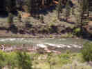
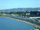 US I-80 in Emeryville US I-80 in Emeryville
|
|||||||||||||||||||||||||||||||||||
|
Other articles:
|
Junction:
| ||||||||||||||||||||||||||||||||||
|
Other articles:
|
Exit 10: AshbyAvenue, California Highway 13 | ||||||||||||||||||||||||||||||||||
|
Other articles:
|
Junction: U. S. Interstate 580, west across the Richmond - San Rafael bridge to San Rafael and U. S. Highway 101 North. | ||||||||||||||||||||||||||||||||||
|
Literature Cited:
|
Junction: Central Avenue Access to the Moeser Lane site of Wakabayashi et al. (2010) containing a block of high-grade metamorphosed Franciscan Formation. | ||||||||||||||||||||||||||||||||||
|
Other articles:
|
Junction: Richmond Parkway | ||||||||||||||||||||||||||||||||||
|
Other articles:
|
Cordelia Junction Junction: US Interstate 680 | ||||||||||||||||||||||||||||||||||
|
Other articles:
|
Junction: California Highway 4 | ||||||||||||||||||||||||||||||||||
|
Other articles:
|
Junction: California Highway 12, east through Rio Vista and Lodi to San Andreas. | ||||||||||||||||||||||||||||||||||
|
Other articles:
|
Junction: U. S. Highway 50. This junction is the beginning of US Highway 50, just west of Sacramento. | ||||||||||||||||||||||||||||||||||
|
|
West Sacramento | ||||||||||||||||||||||||||||||||||
| Bridge over Sacramento River. | |||||||||||||||||||||||||||||||||||
|
|
Sacramento | ||||||||||||||||||||||||||||||||||
|
Other articles:
|
Junction:
| ||||||||||||||||||||||||||||||||||
|
Other articles:
|
AuburnJunction: California Highway 49 | ||||||||||||||||||||||||||||||||||
|
|
Bowman | ||||||||||||||||||||||||||||||||||
|
|
Colfax | ||||||||||||||||||||||||||||||||||
|
|
Monte Vista | ||||||||||||||||||||||||||||||||||
|
|
Towle | ||||||||||||||||||||||||||||||||||
|
|
Baxter | ||||||||||||||||||||||||||||||||||
|
|
Emigrant Gap | ||||||||||||||||||||||||||||||||||
|
Other articles:
|
Yuba PassJunction: California Highway 20 | ||||||||||||||||||||||||||||||||||
|
|
Cisco Grove | ||||||||||||||||||||||||||||||||||
|
|
Soda Springs | ||||||||||||||||||||||||||||||||||
|
|
Troy | ||||||||||||||||||||||||||||||||||
|
Other articles:
|
Euer SaddleCommonly called Donner Pass. Actually the highway croses at Euer Saddle, and Donner Pass is a few miles to the south. | ||||||||||||||||||||||||||||||||||
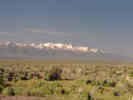
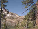 Donner Pass Donner Pass
|
|||||||||||||||||||||||||||||||||||
|
Other articles:
|
Junction: California Highway 89, south. | ||||||||||||||||||||||||||||||||||
|
Locations: Truckee. |
TruckeeJunction: California Highway 267 | ||||||||||||||||||||||||||||||||||
|
Other articles:
|
Junction: California Highway 89, north. | ||||||||||||||||||||||||||||||||||
|
Other articles:
Locations:
Truckee River.
|
Between Truckee, CA and Wadsworth, NV, US Interstate 80 and the Union Pacific Railroad follow the Truckee River. | ||||||||||||||||||||||||||||||||||
|
California above
Nevada below | |||||||||||||||||||||||||||||||||||
|
|
RenoReno receives 80% of the sunshine possible at its latitude. | ||||||||||||||||||||||||||||||||||
|
Other articles:
|
Junction: US Hwy 395, north to Alturas, or south to Mono Lake and Bishop. | ||||||||||||||||||||||||||||||||||
|
Literature Cited:
Locations:
Pah Rah Range.
Truckee River.
|
|||||||||||||||||||||||||||||||||||
|
Other articles:
|
Exit 43: Nevada State Route 427, Main Street, to Wadsworth and Nevada State Route 447 to Gerlach. | ||||||||||||||||||||||||||||||||||
|
Other articles:
|
Exit 46:
| ||||||||||||||||||||||||||||||||||
|
|
Fernley | ||||||||||||||||||||||||||||||||||
|
Literature Cited:
Locations: Bradys Hot Springs. Nightingale Interchange. |
Exit 65: Nightingale Interchange. Bradys Hot Springs.
Jolie, et al. (2016) conducted a case study at the Bradys Hot Springs geothermal field to demonstrate how permeable fractures can be identified and assessed by combining fault stress models with measurements of diffuse degassing and emanations at the Earth's surface. | ||||||||||||||||||||||||||||||||||
|
Literature Cited:
Other articles:
|
Many of the basin valleys of western Nevada were inundated by Lake Lahontan during the Pleistocene. Adams, Wesnousky and Bills (1999) evaluated the rebound of the earth's crust when the weight of the water was removed as the lakes dessicated. One of the effects noted was the diversion of water from one basin to another. The Truckee is example of a river that may have been diverted to a different subbasin because of the effects of isostatic rebound. As the Truckee River exits its deeply incised bedrock canyon between the Pah Rah and Virginia Ranges, it takes an abrupt 90° turn to the northwest and terminates at Pyramid Lake. In the vicinity of Fernley, Nevada, the river is incised about 30 m into a package of surficial deposits that include the outcrops of the Wadsworth Amphitheater. Much of the incision may have occurred after the lake dessicated, which indicates that the Truckee River was lowered onto a relatively flat surface at about 1265-1270 m. What appears to be an abandoned river channel continues east from the vicinity of Fernley into the Fernley Sink. Others first noted this channel, but interpreted it to be pre-Lahontan in age. During the initial lowering of the Truckee River onto this surface the river may have occupied this channel, but the sense of uplift would have the effect of lessening its gradient. Continued rebound may have had the effect of diverting the river to the northwest, parallel to rebound contours, where it became incised into its present channel as base level continued to lower. | ||||||||||||||||||||||||||||||||||
|
Other articles:
|
Exit 83Junction: U. S. Highway 95, south to Fallon. | ||||||||||||||||||||||||||||||||||
| From Exit 83, to the north and east to Winnemucca, US I-80 and US Hwy 95 share the same route. | |||||||||||||||||||||||||||||||||||
|
Other articles:
|
Lovelock | ||||||||||||||||||||||||||||||||||
|
Other articles:
|
Junction:
| ||||||||||||||||||||||||||||||||||
|
Other articles:
Locations:
Rye Patch Reservoir.
|
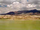
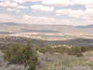
Rye Patch ReservoirThe sign said "Rye Patch Reservoir" so I though I would pull in to see what was there. It's a bit desolate, and as you can see, the water is green from algae. Since I am pretty ignorant about the Humboldt River, I didn't know that its flow was lower here than farther east near Elko. | ||||||||||||||||||||||||||||||||||
|
|
Mill City | ||||||||||||||||||||||||||||||||||
|
Other articles:
|
Junction: W. Winnemucca Blvd. | ||||||||||||||||||||||||||||||||||
| From Winnemucca south and west to Exit 83, near Fernley, US I-80 and US Hwy 95 share the same route. | |||||||||||||||||||||||||||||||||||
|
|
WinnemuccaHighway passes over US Hwy 95. | ||||||||||||||||||||||||||||||||||
| Junction: E. 2nd Street | |||||||||||||||||||||||||||||||||||
|
Other articles:
|
Junction: E. Winnemucca Blvd | ||||||||||||||||||||||||||||||||||
|
Other articles:
Locations: Golconda. |
GolcondaJunction: Golconda Road, Nevada 790, access to Nevada State Route 18. | ||||||||||||||||||||||||||||||||||
|
Other articles:
Locations: Battle Mountain. |
Battle MountainJunction: Nevada State Route 305, south to Austin. | ||||||||||||||||||||||||||||||||||
|
Literature Cited:
Other articles:
Locations: Beowawe. |
| ||||||||||||||||||||||||||||||||||
|
Other articles:
|
Exit 271: Dirt Road, to Palisade and NV Highway 278. | ||||||||||||||||||||||||||||||||||
|
Other articles:
|
Junction: Nevada Highway 278 | ||||||||||||||||||||||||||||||||||
|
Locations: Carlin. |
CarlinNorthwest of Carlin on NV Hwy 766 are the mining districts of the Carlin Trend. | ||||||||||||||||||||||||||||||||||
|
Locations: Carlin Canyon. |
Carlin Canyon | ||||||||||||||||||||||||||||||||||
|
Other articles:
|
Although the tectonic evolution of southwestern North America (present-day) United States) is generally thought to include only two Paleozoic orogenies, the latest Devonian-early Mississippian Antler orogeny and the Late Permiam-earliest Triassic Sonoma orogeny, many workers have shown that there is considerable evidence for deformation at other times in the late Paleozoic. | ||||||||||||||||||||||||||||||||||
|
Literature Cited:
Other articles:
Locations: Adobe Range. Beaver Peak. Carlin Canyon. Coal Mine Canyon. Goose Creek Mountains. Grindstone Mountain. |
Trexler, et al (2004) studied the excellently exposed unconformities in Carlin Canyon and other related locations such as Beaver Peak, Coal Mine Canyon, Grindstone Mountain, and the Goose Creek Mountains. They found that late Paleozoic deformation in the Great Basin is much more widespread and important than has been recognized. The contractional deformation occurred repeatedly between the times generally accepted for the Antler and Sonoma orogenies. | ||||||||||||||||||||||||||||||||||
|
Other articles:
|
Junction: W. Idaho St., to Elko, Nevada. | ||||||||||||||||||||||||||||||||||
|
Other articles:
|
Exit 301: Nevada State Route 225, also known as Mountain City Highway, southeast to Idaho Street, the main street of Elko, Nevada. | ||||||||||||||||||||||||||||||||||
|
Locations:
Elko.
|
Elko | ||||||||||||||||||||||||||||||||||
|
Other articles:
|
Junction: E. Jennings Way, access to Idaho St., in Elko, Nevada. | ||||||||||||||||||||||||||||||||||
|
Other articles:
|
Junction: Idaho Street, frontage road. | ||||||||||||||||||||||||||||||||||
|
Other articles:
Locations:
Ruby Mountains.
|
Exit 321Junction: Nevada Highway 229. | ||||||||||||||||||||||||||||||||||
|
Other articles:
|
Exit 333, Junction: Nevada State Route 230, exit for Deeth. | ||||||||||||||||||||||||||||||||||
|
|
Deeth | ||||||||||||||||||||||||||||||||||
|
Other articles:
|
Exit 343, Junction: Nevada State Route 230, exit for Welcome. | ||||||||||||||||||||||||||||||||||
| Exit 348: ,the old US Highway 40. | |||||||||||||||||||||||||||||||||||
|
Other articles:
|
Exit 351: Humboldt Avenue, turn right for NV SR 231, Angel Lake Road. | ||||||||||||||||||||||||||||||||||
|
Other articles:
Locations: Wells. |
WellsExit 352: U. S. Highway 93. | ||||||||||||||||||||||||||||||||||
|
Other articles:
|
Exit 378: Nevada State Route 233 | ||||||||||||||||||||||||||||||||||
|
|
Wendover | ||||||||||||||||||||||||||||||||||
|
Other articles:
|
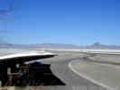
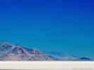
Bonneville Salt Flats | ||||||||||||||||||||||||||||||||||
|
Other articles:
Locations:
Bonneville Salt Flats.
|
| ||||||||||||||||||||||||||||||||||
|
Literature Cited:
Locations: Great Salt Lake. Lake Bonneville. Lake Gunnison. Red Rock Pass. Sevier Lake. Zenda. |
Great Salt Lake State ParkOnce a part of Pleistocene Lake Bonneville, the Great Salt Lake occupies the largest northern basin. The Bear River dominates the hydrologic budget of the Great Salt Lake.The most recent major transgression and regression of Lake Bonneville spanned ~ 14C 30-12 Ka. About 14C 30 Ka Lake Bonneville began to rise from levels close to that of the modern Great Salt Lake. During this rise the lake oscillated at ~ 22-20 14C Ka, producing the Stansbury shoreline complex between 1347 and 1378 m. Following formation of the Stansbury shorelines, Lake Bonneville rose to its highest level of 1552 m by ~ 15.5 14C Ka (the Bonneville stage). At this elevation the lake overflowed intermittently for ~500-100 years near Zenda, Idaho into the Snake River basin, until catastrphic failure of the alluvial threshold dropped the lake level by ~100 m during the Bonneville flood at ~14.5 14C Ka. Immediately following the Bonneville flood, the lake level stabilized at 1450 m by the overflow at Red Rock Pass bedrock threshold, and the Provo shoreline formed. The lake regressed rapidly from the Provo shoreline sometime between 14 and 12 14C Ka, possibly to levels lower than the modern GSL. At the lake level receded past 1390 m, it separated into two basins forming Lake Gunnison in the southern basin. Lake Gunnison apparently continued to overflow along the Old River Bed into the northern basin until ~ 10 14C Ka. The lake remnant occupying the northern basin transgresses to the Gilbert shoreline (~1300 m) ~ 10.3 14C Ka, before dropping to levels <1287 m throughout the Holocene (Oviatt et al., 2001, Hart et al., 2004). | ||||||||||||||||||||||||||||||||||
|
Locations: Salt Lake City. |
Salt Lake City | ||||||||||||||||||||||||||||||||||
|
Junction: US I-215 | |||||||||||||||||||||||||||||||||||
|
Locations: Jordan River. |
Cross Jordan River | ||||||||||||||||||||||||||||||||||
|
Other articles:
|
Junction: U. S. Interstate 15, north, through Idaho and Montana. | ||||||||||||||||||||||||||||||||||
|
Other articles:
|
Junction: U. S. Interstate 15, south, to Las Vegas and Los Angeles. | ||||||||||||||||||||||||||||||||||
|
Other articles:
|
Junction: US Highway 89 | ||||||||||||||||||||||||||||||||||
|
Locations: Parley's Summit. |
Salt Lake County above
Parley's Summit Summit County below | ||||||||||||||||||||||||||||||||||
|
Other articles:
|
Junction: US Highway 40 | ||||||||||||||||||||||||||||||||||
|
Literature Cited:
Locations: Parley's Park. |
Parley's Park. Marcus E. Jones botanized here August 18, 1881, May 16, 1901, | ||||||||||||||||||||||||||||||||||
|
Other articles:
|
Junction: US Interstate 84, northwest through Boise, Idaho, to Portland, Oregon. | ||||||||||||||||||||||||||||||||||
|
Utah above
Wyoming below | |||||||||||||||||||||||||||||||||||
|
Other articles:
|
Exit 66: US Highway 30, northwest in the direction of Idaho. | ||||||||||||||||||||||||||||||||||
|
|
Green River | ||||||||||||||||||||||||||||||||||
|
Other articles:
|
Junction: US Highway 191, south to Vernal, Utah. | ||||||||||||||||||||||||||||||||||
|
Locations: Rock Springs. |
Rock Springs | ||||||||||||||||||||||||||||||||||
|
Other articles:
|
Junction: US Highway 191, north to Yellowstone National Park. | ||||||||||||||||||||||||||||||||||
| Table Rock | |||||||||||||||||||||||||||||||||||
|
Great Divide Basin below | |||||||||||||||||||||||||||||||||||
|
Locations: Red Desert. |
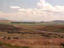
Red DesertExit 165: Red Desert | ||||||||||||||||||||||||||||||||||
|
Other articles:
Locations: Wamsutter. |
WamsutterExit 173: Kelly Street, to Sweetwater County Road 23, Wamsutter-Crooks Gap Road. Wamsutter | ||||||||||||||||||||||||||||||||||
|
Locations: Great Divide Basin. |
Great Divide Basin | ||||||||||||||||||||||||||||||||||
|
Other articles:
|
Exit 187: Wyoming 789, south. | ||||||||||||||||||||||||||||||||||
|
Great Divide Basin above
| |||||||||||||||||||||||||||||||||||
|
|
Rawlins | ||||||||||||||||||||||||||||||||||
|
Other articles:
|
Exit 215:
| ||||||||||||||||||||||||||||||||||
|
Locations: Fort Steele. |
Exit 228: County Road 347, access to the Fort Steele Rest Area, and Fort Fred Steele historic site. | ||||||||||||||||||||||||||||||||||
|
Locations: North Platte River. |
Cross North Platte River Fort Fred Steele is about 2 miles north. | ||||||||||||||||||||||||||||||||||
|
Other articles:
|
WalcottExit 235:
There is not much at Walcott. The Shell station may be open. There are a few houses, but the pads at the mobile home park are mostly empty. | ||||||||||||||||||||||||||||||||||
|
miles pass
| |||||||||||||||||||||||||||||||||||
|
Other articles:
|
Exit 311: WY Highway 130, west to the Snowy Range. | ||||||||||||||||||||||||||||||||||
|
|
Laramie | ||||||||||||||||||||||||||||||||||
|
Other articles:
|
Exit 313: US Highway 287, south to Ft Collins and Denver, Colorado, or west to Rawlins (subparallel to US I-80). | ||||||||||||||||||||||||||||||||||
|
miles pass
| |||||||||||||||||||||||||||||||||||
|
Other articles:
|
Junction: US Interstate 25 | ||||||||||||||||||||||||||||||||||
|
|
Cheyenne | ||||||||||||||||||||||||||||||||||
|
Other articles:
|
Junction: US Interstate 76
Other articles:
Junction: Nebraska Highway 71, south, to Colorado.
Other articles:
Junction: Nebraska Highway 71, north, to Scottsbluff.
Locations:
North Platte.
Exit 177: US Highway 183, to North Platte
Other articles:
Locations:
Gothenburg.
Exit 211: Nebraska Highway 47, to Gothenburg.
Locations:
Omaha.
Exit 452: US Interstate 480, to Omaha.
Date and time this article was prepared:
4/27/2024 3:31:42 PM
|