Eastern Mojave Vegetation
Tom Schweich
|
Eastern Mojave Vegetation
| U. S. Highway 93 |
|
Tom Schweich |

|
(No Preface) | |||
|
United States, Montana below | ||||
| Junction: U. S. Interstate 90 | ||||
|
Montana above
Idaho below | ||||
|
|
Challis | |||
|
Other articles:
|
Junction: Idaho Highway 75 | |||
|
Other articles:
|
ArcoJunction: US Highway 20, US Highway 26, east. | |||
|
|
Carey | |||
|
Other articles:
|
Junction: US Highway 20, west across the Camas Prairie. | |||
|
Other articles:
|
Junction: Idaho Highway 75 | |||
|
|
Shoshone | |||
| Junction: US Highway 26, west. | ||||
|
Other articles:
|
Junction: U. S. Interstate 84. | |||
|
Cross the Snake River on Perrine Memorial Bridge. | ||||
|
Other articles:
|
Junction: US Highway 30, east into downtown Twin Falls, or west to Hagerman and the fossil beds. | |||
|
Idaho above
Nevada below | ||||
|
|
JackpotJackpot is an unincorporated community and census-designated place (CDP) in Elko County, Nevada, United States. The population was 855 as of the 2020 census. Located less than one mile (1.6 km) from the Idaho border on US 93, Jackpot has been a popular casino gaming destination for residents of Idaho and other neighboring states since its founding. The former Union Pacific Wells Branch passed just to the east of Jackpot. | |||
|
Other articles:
Locations: Wells. |
WellsJunction: U. S. Interstate 80. | |||
|
Other articles:
|
Junction: Nevada Highway 229. | |||
|
Literature Cited:
Locations: Goshute Cave. |
Junction: US Highway 93, north to Wendover, Nevada, on US Interstate 80, at the Utah border.
Goshute Cave is about 8 miles to the west, across Steptoe Valley, and on the east side of the Cherry Creek Mountains. | |||
|
Locations: Butte Valley. |
Junction: Cherry Creek Road, former Nevada State Route 489, crosses Steptoe Valley, crosses Cherry Creek Summit, and enters Butte Valley. | |||
|
Other articles:
|
Junction: Nevada State Route 486, east to Duck Creek Valley, and then south. | |||
|
Other articles:
Locations: Steptoe. |
Steptoe is to the east-southeast, behind the copper smelter, on the slopes below the Duck Creek Range. There are several collections of Frasera albomarginata from Steptoe. | |||
|
Locations: McGill. |
McGillMill and smelter. | |||
|
Other articles:
Locations: Ely. |
Ely | |||
|
Other articles:
|
Junction: U. S. Highway 50. | |||
|
Other articles:
|
Junction: U. S. Highway 6.
US Hwy 93 follows the route of US Hwy 50 and US Hwy 6 for 27 miles east of Ely. | |||
|
Other articles:
|
Junction: Nevada State Route 486, east to Cave Valley Lake and then north. | |||
|
Other articles:
|
Junction: U. S. Highway 50, East. (Use U. S. Highway 50 for access to U. S. Highway 6.) | |||
|
Other articles:
|
Junction: Nevada State Route 894, "Shoshone Road", across Spring Valley to the west flank of the Snake Range, and then south to Shoshone and Minerva. | |||
|
Other articles:
Locations:
North Spring Point.
|
North Spring Point | |||
|
Other articles:
|
||||
|
Other articles:
Locations: Bristol Pass. |
Bristol Pass to the west. | |||
|
Other articles:
|
Junction: Bristol Mine Road
Bristol Mine Road goes west through Bristol Pass, turns south past Bristol Wells, and then returns east to Bristol and the Bristol Silver Mines on the west side of the Bristol Range. | |||
|
Other articles:
Locations:
Jackrabbit.
|
Junction: Road to Jackrabbit and Bristol Pass
| |||
|
Other articles:
|
Junction: Nevada State Route 320, west and south through Caselton. | |||
|
Other articles:
Locations: Atlanta. |
Union Pacific Railroad Crossing. Station of Atlanta just to the west of the highway. | |||
|
Other articles:
|
Junction: Nevada State Route 321, business route through downtown Pioche. | |||
|
Other articles:
Locations: Pioche. |
PiocheJunction: Nevada State Route 322, east to Spring Valley State Park.County seat of Lincoln County, NV. Motels: (1) ..., (2) Hutchings Motel, P. O. Box 353, Pioche NV 89043 (702) 962-5404. The Lincoln County Record is published by: Pioche Record Publishing Co, Inc., PO Box 507, Pioche NV 89043. "... a recently chained area [is] available for woodcutters; Reed Cabin Summit chaining is near Eagle Valley State Park and is reasonably accessible" (Lincoln County Record, 126(3), Oct 5, 1995). This was a surprise to me, I thought the BLM had stopped chaining | |||
|
Other articles:
|
Junction: Nevada State Route 321, business route through downtown Pioche. | |||
|
Other articles:
|
Junction: Nevada State Route 320, north through Caselton. | |||
|
Other articles:
|
Cathedral Gorge State Park, Miller Point Overlook. | |||
|
Locations: Cathedral Gorge State Park. |
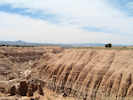
Cathedral Gorge State Park | |||
|
Other articles:
Locations: Panaca. |
Panaca | |||
|
Other articles:
|
Junction: Nevada Highway 319, east to Utah. | |||
|
Literature Cited:
Locations: Panaca Valley. |
The valley in which Panaca lies is called Panaca Valley by the state of Nevada, and Meadow Valley by federal agencies. | |||
|
Other articles:
|
Junction: Beaver Dam Road, 31 miles to Beaver Dam State Park. The road crosses the Union Pacific tracks at Acoma, a former populated place with a post office. A collection of Frasera albomarginata was made near Acoma. | |||
|
Literature Cited:
Locations: Meadow Valley. |
Indian Cove, enter Meadow Valley (Panaca Valley) from the south. | |||
|
Other articles:
Locations: Caliente. |
CalienteMotels and restaurants. Caliente seems more like a center of commerce for Lincoln County than does Pioche or Panaca. | |||
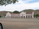 Union Pacific Depot in Caliente, Nevada Union Pacific Depot in Caliente, Nevada
|
Union Pacific Depot | |||
|
Literature Cited:
Locations: Oak Springs Summit. |
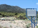
Oak Springs Summit, Delamar Mountains"On the west slope of Hancock Summit (sic), in the Delamar Mountains near Caliente, Joshua trees grow among the sagebrush and juniper well beyond the northern limit of creosote bush, co-indicator (with Joshuas) of the Mojave Desert. Here grows a disorienting mix of plants: juniper, Joshua tree, sagebrush, green rabbitbush, Palmer's penstemon, white prickly-poppy. (Trimble, 1989)"Hancock Summit is, of course, in the pass between the Pahranagat Range and the Mount Irish Range, on Nevada State Route 375, and is about 40 miles to the west of Oak Springs Summit. | |||
|
Other articles:
|
||||
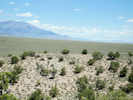
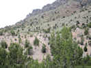
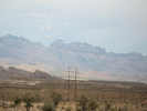
Dry Lake ValleyOn a mid-October morning we encountered four (4) Golden Eagles sitting on fence posts as we crossed Dry Lake Valley, west of the Delamar Mountains. | ||||
Pahroc Range | ||||
|
Other articles:
|
Junction:
| |||
Ash SpringsTaylor, F. R., L. A. Gillman, and J. W. Pedretti. 1989. (Dep Biol. Sci., Univ. Nevada, Las Vegas, Las Vegas, Nevada 89154.); "Impact of cattle on two isolated fish populations in Pahranagat Valley, Nevada [USA]." Great Basin Naturalist. 1989 49(4):491-495. | ||||
|
Other articles:
Locations: Pahranagat Range. |
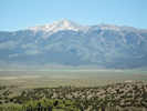
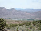
Pahranagat Range with Badger Mountain (elevation 7976 ft.) to the west.
Canyon Road, about 2 miles north of Alamo, may give access to the Pahranagat Range. | |||
|
Locations: Alamo. |
Alamo"On September 12, 1995, the U. S. Fish and Wildlife Service announced in the Federal Register the availability of the Public/Agency Review Draft of the Recovery Plan for the Aquatic and Riparian Species of the Pahranagat Valley" (Lincoln County Record, 126(3), Oct 5 1995). So there must be an issue of native fish and water usage along the White River in the Pahranagat Valley. | |||
|
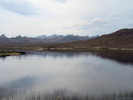
Locations:
Upper Pahranagat Lake.
|
Upper Pahranagat Lake | |||
|
Other articles:
|
Junction: Tikaboo Road, west over Medgser Pass into Badger Valley. Some maps show this road as one of several routes known as "Old Corn Creek Road." | |||
|
Other articles:
Locations:
Lower Pahranagat Lake.
|
||||
|
Other articles:
|
Junction: Alamo Road or Old Corn Creek Road, passing south down the west side of the Sheep Range to US Highway 95 near Corn Creek. | |||
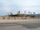 Coyote Springs, home of the palm tree Coyote Springs, home of the palm tree
|
||||
|
Literature Cited:
Other articles:
|
Coyote SpringsJunction: Nevada State Route 168 | |||
 Sheep Range on the west side of Coyote Springs Valley Sheep Range on the west side of Coyote Springs Valley
|
Sheep Range to west of highway. | |||
|
Other articles:
|
Junction: Mormon Well Road | |||
|
Locations: Arrow Canyon Range. |
Arrow Canyon Range to the east. | |||
|
Other articles:
|
Junction: U. S. Interstate 15 | |||
|
US Hwy 93 follows the route of US Interstate 15 for 21 miles. Please refer to the I-15 road log for details between the two junctions. | ||||
|
|
Las Vegas | |||
|
Other articles:
|
Junction:
U. S. Highway 93 is coindicent with U. S. Interstate 515 from the junction with Interstate 15 in the center of Las Vegas through Henderson, Nevada. | |||
|
Other articles:
|
Junction: U. S. Interstate 515, freeway to the center of Las Vegas, Nevada. | |||
|
Other articles:
|
Junction: Nevada State Route 166, north to Boulder Beach. | |||
|
Other articles:
Locations: Hoover Dam. |
Hoover Dam | |||
|
|
KingmanJunction: U. S. Interstate 40, west to Barstow. | |||
| Junction: U. S. Interstate 40, east to Flagstaff. | ||||
|
Other articles:
|
Junction: Arizona Highway 89, north to Prescott, and then to US Interstate 40 near Ash Fork. | |||
|
|
Wickenburg | |||
|
|
Phoenix | |||
| If you have a question or a comment you may write to me at: tas4@schweich.com I sometimes post interesting questions in my FAQ, but I never disclose your full name or address. |
Date and time this article was prepared: 5/10/2024 11:11:13 AM |