Eastern Mojave Vegetation
Tom Schweich
|
Eastern Mojave Vegetation
| Mount Trumbull Loop |
|
Tom Schweich |

|
Also known as Mohave County Route 5. | |
|
Other articles:
|
St. George | |
|
Other articles:
|
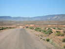
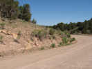
Stopped at the very south end of River Road for this photo. | |
|
Utah above
. Arizona below | ||
|
Other articles:
|
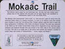
One of several signs for the Mokaac Trail along the road. | |
|
Other articles:
|
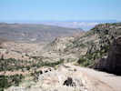
View north toward St. George. | |
|
Literature Cited:
Other articles:
Locations: Mokaac Pass. Mokiak Pass. Quail Hill. |
Quail Hill
| |
|
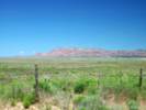
Locations: Seegmiller Mountain. |
Seegmiller Mountain on the east side of the road, has been mistakenly spelled "Sigmiller Mountain," and is also known as "Seegmuller Mountain." | |
|
Other articles:
|
Frasera albomarginata has been collected on the south side of Seegmiller Mountain. | |
|
Other articles:
|
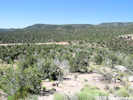
Prime habitat for Frasera albomarginata in a road cut near Mokaac Pass. | |
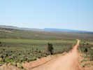
| There is a gentle pass, and to the south is Wolf Hole. This may be the pass called Mokaac Pass. | ||
|
Other articles:
|
View south toward Wolf Hole from near Mokaac Pass. | |
|
Locations: Wolf Hole. |
Wolf Hole | |
|
Other articles:
|
Junction: Mohave County Road 101 "Mud Mountain Road" | |
|
Locations: Sullivan Draw. |
The valley in which Wolf Hole is located continues south where it is known as Sullivan Draw. Mount Trumbull Loop Road turns east and passes over Wolf Hole Pass into Main Street Valley. | |
|
Locations: Wolf Hole Pass. |
Wolf Hole Pass | |
|
Other articles:
|
Jct: County Route 103 "Mount Dellenbaugh Road" | |
|
Other articles:
|
Mt. Trumbull (town) | |
|
Other articles:
Locations: Potato Valley. |
Potato ValleyFrasera albomarginata collected here in Pinyon-Juniper forest. | |
|
Locations: Mount Trumbull. |
Mount Trumbull | |
| Junction: Toroweap Road | ||
|
Literature Cited:
Other articles:
Locations: Vermilion Cliffs. |
| |
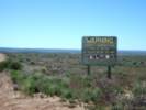 Warning sign on Mt. Trumbull Road. Warning sign on Mt. Trumbull Road.
|
The Sign. | |
|
Other articles:
|
Junction: AZ Highway 389, west to Pipe Springs, east to Fredonia. | |
| If you have a question or a comment you may write to me at: tomas@schweich.com I sometimes post interesting questions in my FAQ, but I never disclose your full name or address. |
Date and time this article was prepared: 5/12/2025 2:41:30 PM |