Eastern Mojave Vegetation
Tom Schweich
|
Eastern Mojave Vegetation
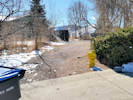
| Ford Street, Golden, Colorado |
|
Tom Schweich |

|
North and South through Golden | ||
|
Other articles:
|
Junction: Colorado State Highway 93 | ||
|
Other articles:
|
Intersection: Pine Ridge Road | ||
| Intersection: Virginia Street | |||
|
Other articles:
|
Intersection: Wyoming Street | ||
| Intersection: Idaho Street | |||
| Intersection: Mesa Drive | |||
|
Other articles:
|
Norman D Park, Tucker Gulch Trail | ||
|
Other articles:
|
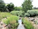
Downstream from Ford Street. | ||
| Intersection: Texas Street | |||
|
Other articles:
|
Intersection: Alaska Street | ||
|
Other articles:
|
Bend in road. Junction: Social Trail, into a small open space and to N. Columbine St. | ||
| Intersection: Iowa Drive, north | |||
| Intersection: Iowa Court | |||
| Intersection: Iowa Drive, south | |||
| Intersection: Iowa Street | |||
|
Other articles:
|
Intersection: Alley, west in the direction of Washington Avenue. | ||
|
Literature Cited:
Other articles:
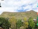
Locations: North Table Mountain. |
Hillside Community Church
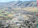
Field Trip Stop 15 North Table Mountain Rockfall Area of Noe, et al. (1999) forms in the parking lot of the Hillside Community Church at 103 N. Ford Street.
| ||
|
Other articles:
|
Intersection: 1st Street | ||
|
Other articles:
|
Alley: between 1st St and 2nd St | ||
|
Other articles:
|
Intersection: 2nd Street | ||
|
Other articles:
|
Intersection: Goldco Circle, north entrance. | ||
|
Other articles:
|
Intersection: Goldco Circle, south entrance. | ||
|
Other articles:
|
Intersection: 5th Street | ||
|
Other articles:
|
Intersection: East Street | ||
|
Other articles:
|
Junction: 7th Place, 7th Street, to Boyd Street, and Golden Cliffs Trailhead. | ||
| Pass under Colorado State Highway 58. | |||
| Intersection: 7th Street, one way eastbound, do not enter. | |||
| Intersection: 8th Street | |||
| Intersection: 9th Street | |||
|
Other articles:
|
Intersection: 10th Street | ||
| Cross Clear Creek with Spurs to: Clear Creek Trail | |||
|
Other articles:
|
Intersection: Clear Creek Trail | ||
| Intersection: 11th Street | |||
|
Other articles:
|
Intersection: 12th Street | ||
|
Other articles:
|
Intersection: 13th Street | ||
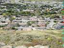
 Castle Rock on South Table Mountain as seen from Bob's Atomic Burger Castle Rock on South Table Mountain as seen from Bob's Atomic Burger
|
Bob's Atomic Burger | ||
|
Other articles:
|
Intersection:
| ||
|
Other articles:
|
Intersection: 15th Street | ||
|
Other articles:
|
Intersection: 16th Street | ||
|
Other articles:
|
Intersection: 17th Street | ||
|
Other articles:
|
Intersection: 18th Street | ||
|
Other articles:
|
Intersection: 19th Street, west to Colorado Highway 93. | ||
| Intersection: 20th Street | |||
| Intersection: 21st Street | |||
| Intersection: 22nd Street | |||
|
|
Bonfire Burritos | ||
|
Other articles:
|
Intersection: 23rd Street | ||
|
Other articles:
|
Intersection: 24th Street | ||
|
Other articles:
|
Intersection: S. Golden Road, Jackson Street | ||
| If you have a question or a comment you may write to me at: tomas@schweich.com I sometimes post interesting questions in my FAQ, but I never disclose your full name or address. |
Date and time this article was prepared: 5/12/2025 2:48:00 PM |