Eastern Mojave Vegetation
Tom Schweich
|
Eastern Mojave Vegetation
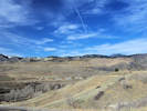
| Colorado State Highway 93 |
|
Tom Schweich |

|
From Boulder to Golden. | ||
|
Other articles:
|
Junction: State Highway 119 | ||
| Junction: State Highway 170 | |||
|
Other articles:
|
Junction: State Highway 128, W. 120th Avenue. | ||
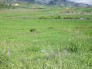
| One to two miles to the east is Section 3 from where there is a single collection of Frasera speciosa. | |||
|
Locations: Rocky Flats. |
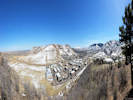
Rocky FlatsRocky Flats stretch for 3 miles north to south, on the east and west sides of the highway. I have seen some references to the “Rocky Flats pediment.” However, it looks more an alluvial fan at the mouth of Coal Creek Canyon. | ||
|
Locations: Rocky Flats National Wildlife Refuge. |
Rocky Flats National Wildlife Refuge | ||
|
Other articles:
|
Junction: State Highway 72, west to Coal Creek Canyon. | ||
|
Junction: Leyden Road | |||
| Junction: W. 82nd Street | |||
|
Other articles:
Locations:
Ralston Dike.
|
Road to Arvada Modelers field, overlook of Ralston Dike. | ||
|
Junction: 64th Parkway | |||
| Junction: W. 66th Avenue | |||
|
Other articles:
|
Junction: W. 58th Avenue, east only, to to W. 60th Avenue | ||
|
Other articles:
Locations: White Ranch Park. |
Junction: W. 56th Avenue, west only, to White Ranch Park. | ||
|
Locations:
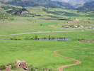
Ramstetter Reservoir.
|
Ramstetter Reservoir east of highway. | ||
|
Other articles:
Locations:
North Table Mountain Park.
|
North Table Mountain Trailhead. Access to North Table Mountain from the west side. | ||
|
Other articles:
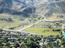
Locations:
Golden.
|
City of Golden below | ||
|
Other articles:
|
Junction:
| ||
|
Other articles:
|
Junction: Golden Gate Canyon Road, County Road 70 | ||
|
Other articles:
|
Junction: Washington Avenue | ||
|
Other articles:
|
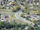
Junction: Iowa Drive, west into Mountain Ridge subdivision, east towards Washington Avenue and Iowa Street. | ||
| Bicycle bridge crosses the highway. | |||
|
Literature Cited:
|
The highway passes near the center of the NE1/4 SW1/4 Sect 28, T3S, R70W.
Somewhere in this quarter-quarter section are the locations of two trenches dug to explore a small graben of Quaternary age, thought to be related to the Golden fault. Excavations revealed a complex geologic picture suggesting two periods of fault rupture with a total of 5.5 m of displacement. Dating of zircons and glass shards from an ash deposited in the graben and disrupted by faulting yielded dates of 0.6 to 0.7 million years, suggesting faulting occurred more recently than those dates (Kirkham, 1977). | ||
|
Literature Cited:
Other articles:
Locations: Magpie Gulch. |
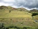
Field Trip Stop 14 Highway 6-58-93 Junction of Noe, et al. (1999) illustrates the Golden Fault, associated landslide hazards, mitigation of landslide hazards, and the short public memory. Looking to the north and south, we can see the distinctive hogback of the Dakota Sandstone at both ends of the valley. But why is this hogback missing at the valley center? The answer is that the Golden Fault, a large, Laramide thrust fault, weaves along the valley just to the east of the mountain front. Here, the fault has displaced nearly 8,000 feet of the Paleozoic and Mesozoic, sedimentary section (Van Horn, 1976). The trace of the fault can be seen as it cuts up the side of the first large alluvial terrace to the south of Clear Creek. There is a distinct break in the vegetation between the Fountain Formation to the west (covered with mountain mahogany shrubs) and the Pierre Shale to the east (covered with grasses). | ||
|
Other articles:
|
Junction:
| ||
| If you have a question or a comment you may write to me at: tomas@schweich.com I sometimes post interesting questions in my FAQ, but I never disclose your full name or address. |
Date and time this article was prepared: 5/12/2025 2:49:36 PM |