Eastern Mojave Vegetation
|
Eastern Mojave Vegetation
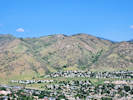
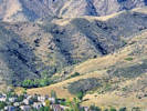
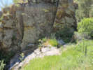
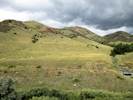
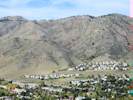
| Magpie Gulch, Jefferson County, Colorado. |
|
Gazetteer Query: See also: Golden.
|
|||||||||||
|
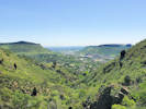
Small gulch emptying into Clear Creek at north side of Golden.
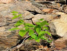
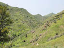
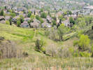
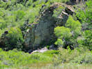
Name not recognized by U. S. Board on Geographic Names. Field Trip Stop 14 — Highway 6-58-93 Junction — of Noe, et al. (1999) illustrates the Golden Fault, associated landslide hazards, mitigation of landslide hazards, and the short public memory. Looking to the north and south, we can see the distinctive hogback of the Dakota Sandstone at both ends of the valley. But why is this hogback missing at the valley center? The answer is that the Golden Fault, a large, Laramide thrust fault, weaves along the valley just to the east of the mountain front. Here, the fault has displaced nearly 8,000 feet of the Paleozoic and Mesozoic, sedimentary section (Van Horn, 1976). The trace of the fault can be seen as it cuts up the side of the first large alluvial terrace to the south of Clear Creek. There is a distinct break in the vegetation between the Fountain Formation to the west (covered with mountain mahogany shrubs) and the Pierre Shale to the east (covered with grasses).
Articles that refer to this location:
Literature Referring To This Location:
Area Plant Lists that contain this location:
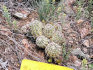
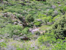
Species collected at or near this location. This list summarizes plants collected or observed at this specific, named location. It does not include plants collected or observed at nearby named or unnamed locations. It may be more instructive to use the Area Lists that contain this location.
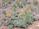
Cupressaceae Juniperus scopulorum Sarg. Rocky Mountain Juniper (Obs) Pinaceae Pinus ponderosa Laws. Ponderosa Pine (Obs) Pseudotsuga menziesii (Mirb.) Franco. Douglas Fir (Obs) Anacardiaceae Rhus glabra L. Smooth Sumac (Obs) Rhus trilobata Nutt. trilobata. Skunkbush Sumac (Obs) Toxicodendron rydbergii (Small ex Rydb.) Greene. Western Poison Ivy (Obs) Apiaceae Conium maculatum L. Common Poison Hemlock (Obs) Lomatium orientale J.M. Coult. & Rose. Salt-and-Pepper (TAS+Obs) Asclepiadaceae Asclepias viridiflora Raf. Green Comet Milkweed (Obs) Asteraceae Achillea millefolium L. Common Yarrow (Obs) Artemisia frigida Willd. Prairie Sagewort (Obs) Artemisia ludoviciana Nutt. Silver Wormwood (Obs) Carduus nutans L. Nodding Plumeless Thistle (Obs) Cirsium arvense (L.) Scop. Canada Thistle (Obs) Cirsium undulatum (Nutt.) Spreng. Wavy Leaved Thistle (Obs) Cirsium vulgare (Savi) Ten. Bull Thistle (Obs) Erigeron divergens Torr. & A. Gray. Spreading Fleabane (Obs) Erigeron tracyi Greene. Running Fleabane (Obs) Grindelia squarrosa (Pursh) Dunal. Curlycup Gumweed (Obs) Helianthus pumilus Nutt. Little Sunflower (Obs) Heliomeris multiflora Nutt. multiflora. Showy Golden Eye (TAS) Heterotheca villosa (Pursh) Shinners. Hairy False Goldenaster (Obs) Liatris punctata Hook. Dotted Blazing Star (Obs) Lygodesmia juncea (Pursh) D. Don ex Hooker. Rush Skeletonplant (Obs) Packera fendleri (A. Gray) W.A. Weber & Á. Löve. Fendler’s Ragwort (Obs) Pseudognaphalium canescens (DC.) Anderberg. Wright's Rabbit-Tobacco (Obs) Senecio integerrimus Nutt. Columbia Ragwort (Obs) Symphyotrichum porteri (A. Gray) G.L. Nesom. Smooth White Aster (TAS) Thelesperma megapotamicum (Spreng.) Kuntze. Hopi Tea Greenthread (Obs) Tragopogon dubius Scop. Yellow Salsify (Obs) Berberidaceae Berberis repens Lindl. Creeping Barberry (Obs) Boraginaceae Cynoglossum officinale L. Gypsyflower (Obs) Hydrophyllum fendleri (A. Gray) A. Heller. Fendler's Waterleaf (Obs) Lappula occidentalis (S. Watson) Greene. Flatspine Stickseed (Obs) Lithospermum incisum Lehm. Narrowleaf Stoneseed (Obs) Lithospermum occidentale (Mack.) Weakley, Witsell & D. Estes. Western Marbleseed (Obs) Mertensia lanceolata (Pursh) DC. Prairie Bluebells (Obs) Phacelia heterophylla Pursh. Varileaf Phacelia (Obs) Brassicaceae Alyssum simplex Rudolphi. European Madwort (Obs) Arabis pycnocarpa M. Hopkins pycnocarpa. Cream Flower Rockcress (Obs) Descurainia pinnata (Walter) Britton brachycarpa (Richardson) Detling, Amer.Midl. Naturalist. 22: 509. Western Tansymustard (TAS) Erysimum capitatum (Hook.) Greene. Sanddune Wallflower (Obs) Physaria montana (A. Gray) Greene. Mountain Bladderpod (Obs) Thlaspi arvense L. Field Penny Cress (Obs) Turritis glabra L. Tower Rockcress (Obs) Cactaceae Echinocereus viridiflorus Engelm. Nylon Hedgehog Cactus (Obs) Opuntia macrorhiza Engelm. Western Pricklypear (Obs) Opuntia polyacantha Haw. Plains Pricklypear (Obs) Campanulaceae Campanula rotundifolia L. Harebell (Obs) Cannabaceae Celtis occidentalis L. Western Hackberry (Obs) Celtis reticulata Torr. Net-Leaved Hackberry (Obs) Caprifoliaceae Symphoricarpos rotundifolius A. Gray. Roundleaf Snowberry (Obs) Caryophyllaceae Cerastium arvense L. strictum Gaudin. Field Chickweed (Obs) Pseudostellaria jamesiana (Torr.) W. A. Weber & R. L. Hartm. Tuber Starwort (Obs) Saponaria officinalis L. Bouncingbet (Obs) Chenopodiaceae Chenopodium album L. Lambsquarters (Obs) Convolvulaceae Evolvulus nuttallianus Roem. & Schult. Shaggy Dwarf Morning Glory (Obs) Crassulaceae Sedum acre L. Goldmoss Stonecrop (Obs) Sedum lanceolatum Torr. Spearleaf Stonecrop (Obs) Elaeagnaceae Elaeagnus angustifolia L. Russian Olive (Obs) Euphorbiaceae Euphorbia esula L. Leafy Spurge (Obs) Euphorbia peplus L. Petty Spurge (TAS) Tragia ramosa Torr. Branched Noseburn (Obs) Fabaceae Dalea purpurea Vent. Purple Prairie Clover (Obs) Lupinus argenteus Pursh. Loosely Flowered Silver Lupine (Obs) Oxytropis lambertii Pursh. Purple Locoweed (Obs) Pediomelum tenuiflorum (Pursh) A. N. Egan. Slimflower Scurfpea (Obs) Robinia pseudoacacia L. Black Locust (Obs) Thermopsis rhombifolia (Nutt. ex Pursh) Nutt. ex Richardson divaricarpa (A. Nelson) Isely. Spreadfruit Goldenbanner (Obs) Vicia americana Willd. American Vetch (Obs) Fumariaceae Corydalis aurea Willd. Scrambled Eggs (TAS+Obs) Geraniaceae Geranium viscosissimum Fisch. & C. A. Mey. ex C. A. Mey. Sticky Purple Geranium (Obs) Grossulariaceae Ribes cereum Douglas. Wax Currant (Obs) Hypericaceae Hypericum perforatum L. Common St. John's Wort (Obs) Lamiaceae Marrubium vulgare L. Horehound (Obs) Mentha spicata L. Spearmint (Obs) Monarda fistulosa L. Wild Bergamot (Obs) Salvia L. Sage (Obs) Scutellaria brittonii Porter. Britton's Skullcap (Obs) Loasaceae Mentzelia. Blazing Star (Obs) Mentzelia albicaulis (Douglas ex Hook.) Douglas ex Torr. & A. Gray. White-Stem Blazing Star (TAS) Malvaceae Sphaeralcea coccinea (Nutt.) Rydb. Cowboy's Delight (Obs) Nyctaginaceae Mirabilis linearis (Pursh) Heimerl. Narrowleaf Four O'Clock (Obs) Mirabilis nyctaginea (Michx.) MacMill. Heartleaf Four O'Clock (Obs) Oleaceae Fraxinus pennsylvanica Marshall. Green Ash (Obs) Syringa vulgaris L. Common Purple Lilac (Obs) Onagraceae Oenothera coronopifolia Torr. & A. Gray. Crownleaf Evening Primrose. Hierba de San Juan. (Obs) Oenothera curtiflora W.L. Wagner & Hoch. Velvet Butterfly-Weed (Obs) Oenothera suffrutescens (Ser.) W. L. Wagner & Hoch. Linda Tarde (Obs) Papaveraceae Argemone polyanthemos (Fedde) G.B. Ownbey. Crested Prickly Poppy (Obs) Phrymaceae Erythranthe floribunda (Douglas ex Lindl.) G. L. Nesom. Many Flowered Monkey Flower (TAS) Plantaginaceae Collinsia parviflora Lindl. Maiden Blue-eyed Mary (Obs) Linaria dalmatica (L.) Mill. Dalmatian ToadFlax (Obs) Penstemon Schmidel. Beard Tongue (Obs) Penstemon secundiflorus Benth. Sidebells Penstemon (Obs) Penstemon virens Pennell ex Rydb. Front Range Beardtongue (Obs) Polemoniaceae Gilia ophthalmoides Brand. Pinyon Gilia (TAS) Phlox multiflora A. Nelson. Mountain Phlox (Obs) Polygonaceae Eriogonum alatum Torrey in L. Sitgreaves, Rep. Exped. Zuni Colorado Rivers. 168, plate 8. 1853. Winged Buckwheat (Obs) Eriogonum effusum Nuttall, Proc. Acad. Nat. Sci. Philadelphia. 4: 15. 1848. Spreading Buckwheat (Obs) Eriogonum jamesii Bentham in A. P. de Candolle and A. L. P. P. de Candolle, Prodr. 14: 7. 1856. James' Buckwheat (Obs) Fallopia convolvulus (L.) A.Löve. Black Bindweed (Obs) Rumex venosus Pursh. Veiny Dock (Obs) Primulaceae Dodecatheon pulchellum (Raf.) Merr. Beautiful Shootingstar (TAS+Obs) Ranunculaceae Clematis L. Clematis (Obs) Delphinium carolinianum Walter virescens (Nutt.) R.E. Brooks. Plains Larkspur (Obs) Delphinium nuttallianum Pritz. Twolobe Larkspur (Obs) Rosaceae Amelanchier alnifolia (Nutt.) Nutt. ex M. Roem. Saskatoon Serviceberry (Obs) Cercocarpus montanus Raf. Alder-Leaf Mountain Mahogany (Obs) Crataegus erythropoda Ashe. Cerro Hawthorn (TAS) Crataegus succulenta Schrad. ex Link. Fleshy Hawthorn (Obs) Malus L. Apple (Obs) Potentilla fissa Nutt. ex Torr. & A.Gray. Bigflower Cinquefoil (Obs) Potentilla norvegica L. Norwegian Cinquefoil (TAS) Physocarpus monogynus (Torr.) J.M. Coult. Mountain Ninebark (Obs) Prunus virginiana L. Chokecherry (Obs) Rosa woodsii Lindl. Mountain Rose (Obs) Rubus deliciosus Torr. Delicious raspberry (Obs) Rubiaceae Galium aparine L. Sticky Willy, Cleavers (Obs) Salicaceae Populus × acuminata Rydb. Lanceleaf Cottonwood (Obs) Populus angustifolia E. James. Narrowleaf Cottonwood (Obs) Populus deltoides Marshall monilifera (Aiton) Eckenw. Plains Cottonwood (Obs) Salix exigua Nutt. Coyote Willow, Narrow-Leaved Willow (Obs) Santalaceae Comandra umbellata (L.) Nutt. pallida (A. DC.) Piehl. Pale Bastard Toadflax (Obs) Sapindaceae Acer glabrum Torr. Rocky Mountain Maple (Obs) Saxifragaceae Heuchera parvifolia Nutt. ex Torr. & A. Gray. Littleleaf Alumroot (TAS) Scrophulariaceae Scrophularia lanceolata Pursh. Lanceleaf Figwort (Obs) Verbascum thapsus L. Common Mullein (Obs) Ulmaceae Ulmus pumila L. Siberian Elm (Obs) Urticaceae Parietaria pensylvanica Willd. Pennsylvania Pellitory (TAS) Violaceae Viola nuttallii Pursh. Nuttall's Violet (Obs) Vitaceae Parthenocissus Planchon. Virginia Creeper (Obs) Vitis riparia Michx. Riverbank Grape (Obs) Agavaceae Yucca glauca Nutt. Soapweed Yucca (Obs) Alliaceae Allium textile A. Nelson & J.F. Macbr. Textile Onion (TAS+Obs) Anthericeae Leucocrinum montanum Nutt. ex A. Gray. Star Lily (Obs) Asparagaceae Asparagus officinalis L. Asparagus (Obs) Commelinaceae Tradescantia occidentalis (Britton) Smyth. Prairie Spiderwort (Obs) Cyperaceae Carex L. Sedge (Obs) Eleocharis R. Br. Spikerush (Obs) Eleocharis quinqueflora (Hartmann) O. Schwarz. Fewflower Spikerush (TAS) Iridaceae Iris L. Horticultural Iris (Obs) Juncaceae Juncus bufonius L. Toad Rush (TAS) Poaceae Aristida purpurea Nutt. longiseta (Steud.) Vasey. Purple Threeawn (Obs) Bromus inermis Leyss. Smooth Brome (Obs) Bromus tectorum L. Cheat Grass (Obs) Festuca trachyphylla (Hack.) Krajina. Hard Fescue (TAS) Hesperostipa comata (Trin. & Rupr.) Barkworth. Needle and Thread (Obs) Koeleria macrantha (Ledeb.) Schult. Prairie Junegrass (Obs) Munroa squarrosa (Nutt.) Torr. False Buffalograss (Obs) Poa. (TAS) Poa pratensis L. Kentucky Bluegrass (Obs) Sorghastrum nutans (L.) Nash. Yellow Indian Grass (Obs) Sporobolus cryptandrus (Torr.) A. Gray. Sand Drop-seed (Obs)
| |||||||||||
| |||||||||||
| If you have a question or a comment you may write to me at: tomas@schweich.com I sometimes post interesting questions in my FAQ, but I never disclose your full name or address. |
A, B, C,
D, E, F,
G, H, I,
J, K, L,
M, Date and time this article was prepared:8:31:54 PM, 4/21/2025. | ||||||||||