Eastern Mojave Vegetation
Tom Schweich
|
Eastern Mojave Vegetation
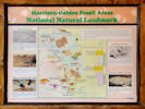
| Triceratops Trail, Golden, Jefferson County, Colorado |
|
Tom Schweich |

|
To several locations that fossils can be seen. | ||||||||||||||||||||||||||||||||||||||||||||||||
|
Other articles:
|
Junction: 6th Avenue Trail
Other articles:
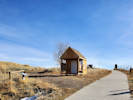
Information Kiosk
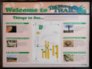
This one-mile trail winds through an old clay mine,
owned and operated byt the Parfet family from the 1870's to the 1990's.
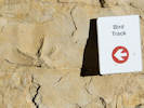
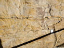
The signs along this trail help interpret the evidence left by dinosaurs,
other animals and plants of Late Cretaceous time.
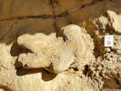
Trace fossils resulting from animal activity as well as leaf and log impressions
are useful in reconstructing prehistoric environments.
Trail reverses direction.
Other articles:
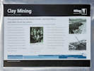
Overlook view of clay pit.
Spur trail into clay pit
Other articles:
In 1877, George W. Parfet,
Senior began mining the rich clay from between the harder sandstone layers
and restored Golden's mantle as a mning hotspot.
This mine was named the Rockwell and in its heyday
it shipped 70-75 rail cars filled with clay weekly,
each weighing over 2,000 tons!
Bricks made from this clay were used in the
Jefferson County Hall of Justice and the Human Services buildings,
Denver East and South high schools,
the Governor's Mansion and more.
The mine closed in 2001 and was reclaimed in 2002 by the City of Golden. Sign sponsored by the Golden Civic Foundation. Other articles:
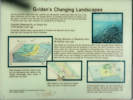
Overlook
Several mountain ranges have been uplifted and subsequently eroded away before the rise of the Rocky Mountains you see today.
The geologic history of Colorado started nearly two billion years ago,
and is recorded in the old rocks seen in the mountains to the west.
We start our discussion 72 million years ago,
when Colorado was inundated by an inland sea. An ancient shallow seaway covered much of Colorado and deposited marine shale (mud and clay) forming the Pierre Formation. The inland sea retreated with the beginning uplift of the Laramide Rocky Mountains.
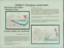
Rivers carried sediment from the mountains to the shore (Fox Hills Formation).
Along the rivers, sand, clay, and coal were deposited in alternating layers.
These river and swamp deposits are the Laramie Formation.
Dinosaurs and plant debris made impressions on muddy surfaces before being buried by sand that washed in from periodic floods.
The rocks where you are now standing are about 68 million years old.
The following diagrams show how the rocks you see along the Triceratops Trail were formed.
When dinosaurs left their tracks at this site,
the environment was similar to the swampy Mississippi Delta region of modern-day Louisiana.
River channels were flanked by swamps where clay and coal deposits formed.
During periodic floods, the river breached its banks, spilling sand across the swamps.
This repeated flooding created the alternating sand and clay layers that we see here.
As uplift of the Rockies continued,
strata originally deposited horizontally were tilted to near vertical.
55-34 millions years ago, The Laramie Rocky Mountains were eroded down to a gently sloping surface.
Sediments, carried by rivers, buried the mountain front and spread across the eastern plains. The present-day Rocky Mountains were uplifted to their current elevations.
Rivers cut into their present valleys removing softer rock and leaving more resistant rocks.
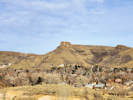
This erosion created features such as the high mountains of the Continental Divide,
the jagged rock formations of Red Rocks, Dinosaur Ridge, Green Mountain,
and the Table Mountains Sign sponsored by SCFD, the Colorado Scientific Society, and Dr. Robert Weimer. Trail reverses direction.
Other articles:
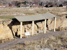
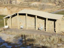
Interpretive shed
Other articles:
Interpretive shed
End of Trail
Date and time this article was prepared:
4/21/2025 8:19:09 PM
|