Eastern Mojave Vegetation
Tom Schweich
|
Eastern Mojave Vegetation
| Forest Road 211, Pike-San Isabel National Forest |
|
Tom Schweich |

|
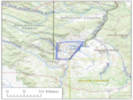
From Deckers Road south to Tarryall Road, about 25 miles. The first couple miles and last couple miles are the worst. | |||||
|
Other articles:
|
Junction: County Road 126 “Deckers Road” | |||||
|
Other articles:
Locations:
Dispersed Camp Site.
|
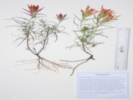
COJefPSIDSX1: Location of a dispersed camping site we used a a base to collect from.
| |||||
|
Other articles:
|
Where the road turns south | |||||
|
Locations:
North Twin Creek.
Tarryall Mountains, East Slope.
|
Cross North Twin Creek | |||||
|
Locations: Twin Creek. |
Cross Twin Creek. | |||||
|
Molly Gulch Campground to the east | ||||||
|
Entrance to Molly Gulch Campground | ||||||
|
Cross Molly Gulch. | ||||||
|
Literature Cited:
Other articles:
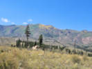
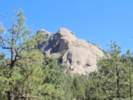
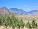
Locations: Sheeprock. |
View of Sheep Rock.
| |||||
|
Junction: Road to Lost Valley Ranch | ||||||
|
Locations: Geographic Center of Colorado. |
Divide between Molly Gulch and Goose Creek. About 200 m. east is one of several geographic centers of Colorado. A number of vouchers have been georeferenced to this point, but I do not think they actually occur on the east slope of the Tarryall Mountains. | |||||
|
Other articles:
|
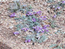
Pull-off just north of road cut; location of Coll. No. 2470, Astragalus multiceps | |||||
|
|
Goose Creek Campground | |||||
|
Other articles:
|
Junction: FR 558, to Goose Creek Trailhead. | |||||
|
Literature Cited:
Other articles:
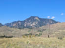
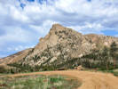
Locations: Sheeprock. Tarryall Mountains. |
View of Sheeprock. Pull out just south od Wildcat Creek.
| |||||
|
Jefferson County above Park County below | ||||||
|
Other articles:
|
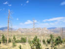
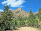
View of Pilot Peak | |||||
Topaz Mountain Gem Mine | ||||||
|
Other articles:
|
Junction: County Road 77, “Tarryall Road” | |||||
| If you have a question or a comment you may write to me at: tomas@schweich.com I sometimes post interesting questions in my FAQ, but I never disclose your full name or address. |
Date and time this article was prepared: 5/12/2025 2:49:06 PM |