
|
(No Preface)
|
|
Other articles:
• Utah Highway 24:
55000;
|
Junction: Utah Highway 24
|
|
Literature Cited:
- Smith, Beatrice Scheer, 1994.
Other articles:
• Field Notes:
8 Oct 2017;
Locations:
Larb Hollow.
|
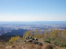
Larb Hollow Overlook
Interpretive panel at Larb Hollow Overlook. |
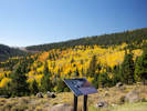
Turning aspens at Larb Hollow Overlook |
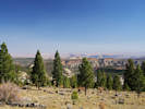
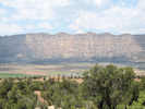
View across Waterpocket Fold to San Rafael Desert |
Overlook of Larb Hollow with a Forest Service pooper.
The Henry Mountains were also visible to the southwest, but the photograph was looking into the sun and poor quality.
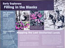
Early Explorers: Filling in the Blanks
|
Ellen Thompson, Expedition Botanist
Ellen Thompson, wife of A. H. Thompson and sister of John Wesley Powell,
served as botanist on the second Powell Expedition.
She collected hundreds of plants,
many of them new to science.
Several were named in her honor,
including Thompson's Penstemon (Penstemon thompsoniae)
and Thompson's Woolly Locoweed (Astragalus mollissimum var. thompsoniae).
Mount Ellen, in the Henry Mountains, is also named for her.
“I never felt more exultant in my life
I was looking on the most wonderful scenery I ever beheld.”
|
Andrus Expedition, 1866
“
as far as the Eye can see a naked barren plain
of red and white Sandstone crossed in all directions by
innumerable gorges
”
-- Franklin B. Woolley, Andrus Expedition, 1866.
Several years before the Powell Expedition,
the Andrus military expedition patrolled the Aquarius Plateau region,
providing the first written descriptions of this area.
|
Mapping the Last Uncharted Lands
By 1870, the continental United States had been mapped and surveyed,
except for one area -- the vast region that surrounds you.
From the Colorado River to the Aquarius Plateau,
and from the Virgin River to the Green, this rugged landscape was
uncharted territory.
Though the Fremont Expedition passed through Capitol Reef during the
winter of 1853-54,
they were desperately low on provisions and did not linger to survey the region.
In 1872, John Wesley Powell launched his second expedition down thw
Green and Colorado Rivers to chart the Rivers and surrounding lands.
Over the next four years, his brother-in-law, Almon H. Thompson,
led the land survey of southern Utah,
during which he explored and charted Boulder Mountain
and the rest of the Aquarius Plateau.
The expedition also named and mapped the Escalante River and the Henry Mountains,
respectively the last-mapped river and mountain range in the lower 48 states.
|
|
|
Other articles:
• Field Notes:
8 Oct 2017;
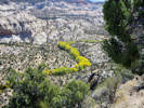
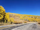 Turning aspens on Boulder Mountain Turning aspens on Boulder Mountain
|
Aspens
|
|
Other articles:
• Field Notes:
8 Oct 2017;
Locations:
Point Lookout.
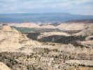
 View south from Boulder Mountain View south from Boulder Mountain
|
Interpretive panel |
Southerly view of Circle Cliffs.
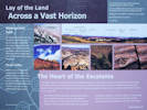
Lay of the Land: Across a Vast Horizon
“To a life that accepts Nature's hand in sculpting an
individual expression – Nothing is exempt.
From the mellifluous rhythm and tome of the wid chime,
to the transitional form of the cloud –
Nothing exists alone.
All things thrive and whither in confluence with one another.
So it is; the paradox of our divinity.”
– Dave Buschow
Waterpocket Fold
The 100-mile-long Waterpocket Fold forms the backbone of Capitol Reef National Park.
Here, geologic rock layers drape over a steeply dipping fault plane.
Over millennia, water and wind have eroded the soft layers,
sculpting the Waterpocket Fold's intricate contours.
Along the Fold, water collects in sandstone basins,
forming “waterpockets.”
Circle Cliffs
Within this section of Grand Staircase - Escalante National Monument
lie huge petrified wood logs, some nearly 90 feet long.
These rocks formed from trees that grew some 210 million years ago.
The logs were buried in river sediments and became “petrified”
as silica from volcanic ash gradually replaced organic cell tissue.
The Heart of the Escalante
“The Aquarius should be described in blank verse and illustrated upon canvas.
The explorer who sits upon the brink of its parapet looking off into the southern and eastern haze,
who skirts its lava cap or clambers up and down its vast ravines,
who builds his camp fire by the borders of its snow-fed lakes
or stretches himself beneath its giant pines and spruces,
forgets that he is a geologist and feels himself a poet.”
– Clarence Dutton, 1880
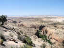
The wild heart of the Escalante River drainage spreads before you
– a labyrinth of canyons, mesas, and rolling slickrock.
Remote peaks grace the horizon.
On the far left lie the Henry Mountains,
the last-named mountain range in the continental United States
and home to one of the country's few free-roaming bison herds.
Follow the horizon south, and you'll reach the rounded dome of Navajo Mountain on the Utah-Arizona border.
|
|
|
|
Boulder
|
|
Other articles:
• Road 1668 "Burr Trail":
at UT Hwy 12;
|
Junction: Road 1668 "Burr Trail Road"
|
|
Other articles:
• Field Notes:
7-Jun-08 near Boulder;
 View of Boulder from south. View of Boulder from south.
|
|
|
Other articles:
• Field Notes:
7-Jun-08 south of Boulder;
 View north toward Boulder View north toward Boulder
|
|
|
Other articles:
• Field Notes:
7-Jun-08 near Boulder;
8 Oct 2017;
Locations:
The Hogback.
 Calf Creek from UT Hwy 12. Calf Creek from UT Hwy 12.
|
Boulder Creek below Utah Highway 12 |
|
|
Other articles:
• Utah Highway 12:
on UT Hwy12;
Locations:
Head of the Rocks.
|
Head of Rocks Overlook
Highway Overlook, on the route of the 2nd Powell Expedition from Henrieville.
|
|
Other articles:
• Frasera albomarginata:
near Escalante;
|
5 miles east of Escalante. Holmgren and Nielsen (#7723 UC943237) collected Frasera albomarginata five miles east of Escalante on rocky places in Pinyon-Juniper.
|
|
Other articles:
• Field Notes:
7-Jun-08 near Escalante;
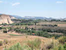
 View of the Straight Cliffs near Escalante View of the Straight Cliffs near Escalante
|
|
|
Other articles:
• Hole-in-the-Rock Road:
at UT Hwy 12;
|
Junction: Hole-in-the-Rock Road
|
|
Other articles:
• Field Notes:
7-Jun-08 in Left Hand Collet Canyon;
7-Jun-08 near Escalante;
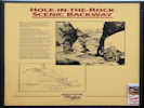 Hole-in-the-Rock Scenic Byway Hole-in-the-Rock Scenic Byway
|
|
|
Locations:
Escalante.
|
Escalante
|
|
Other articles:
• Field Notes:
8 Oct 2017;
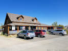 Escalante Outfitters, supplies and food Escalante Outfitters, supplies and food
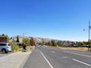 Western end of Escalante Western end of Escalante
|
Escalante Outfitters, supplies and food.
|
|
Other articles:
• Field Notes:
7-Jun-08;
Locations:
Escalante Petrified Forest State Park.
 Entrance to Escalante Petrified Forest State Park Entrance to Escalante Petrified Forest State Park
|
Escalante Petrified Forest State Park.
|
|
Other articles:
• Field Notes:
7-Jun-08;
Locations:
Wide Hollow Reservoir.
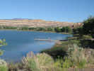 Wide Hollow Reservoir near Escalante Petrified Forest State Park. Wide Hollow Reservoir near Escalante Petrified Forest State Park.
|
Wide Hollow Reservoir north of the highway.
|
|
Other articles:
• Field Notes:
20080608030;
 Summit on Utah Highway 12 Summit on Utah Highway 12
|
View east on Utah Highway 12 from the viewpoint.
|
|
Other articles:
• Field Notes:
8-Jun-08 in Utah;
8 Oct 2017;
• Utah Highway 12:
at Head of Rocks;
Locations:
Powell Point.
 Powell Point from Utah Highway 12 Powell Point from Utah Highway 12
|
Powell Point Vista
Interpretive sign at highway viewpoint. |
Powell Point from Utah Highway 12 (2017) |
Interpretive plaque on the Second Powell Expedition |
Interpretive plaque about the Kaiparowits Formation |
Powell Point from the viewpoint.
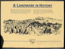
Landmark in History
|
|
John Wesley Powell ... The name alone
invokes thoughts of adventure, bravery,
exploration, and men pitted against
nature. Powell expeditions of 1869-1872
on the Green and Colorado Rivers have
sparked the imaginations of readers and
river runners for more than a hundred
years.
|
|
Powell's explorations were more than
adventures. They provided valuable
information about unmapped regions.
Powell Point was used as a landmark
survey point by the Powell Expedition.
Powell Point dominates the landscape,
rising 10,188 feet above sea level.
|
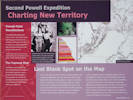
Second Powell Expedition: Charting New Territory
Powell Point Recollections
“We still keep Table Mountain (Pink Point) to our left
this singular mountain suggests a monster melon, sliced and standing on end.
It is exactly the color of a ripe, red core;
the pines that grow on ledges and benches, black specks at this distance,
look like weeds.”
– Walter Clement Powell, member of the Second Powell Expedition of 1871,
describing their ascent of the Blues Formation to the base of Powell Point.
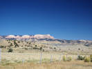
The Topmost Stair
Powell Point reveals the topmost layer of the Colorado Plateau's
Grand Staircase.
This brilliantly colored layer, known as the Pink Cliffs or Claron Formation,
is the same geologic layer that forms the spectacular,
pinnacled landscape of Bryce Canyon National Park and Red Canyon,
farther west on Highway 12.
Last Blank Spot on the Map
In 1871, this region was part of the last uncharted territory in the
continental United States.
That year, Major John Wesley Powell launched the Second Powell Expedition
to explore and map this frontier,
continuing the work he had begun three years earlier.
Powell led the expedition safely through the wild waters of the
Green and Colorado Rivers to the Paria River.
He then instructed his brother-in-law Almon H. Thompson
to lead the expedition overland to map what they called
“the unknown country.”
In 1872, expedition members climbed the slippery slopes of
the badlands on which you now stand.
Thompson then scaled the brilliant pink formation
above you to view the surrounding country.
Over the next four years, Thompson's explorations
filled in this last blank spot on the U. S. map.
In 1879, surveyor Clarence Dutton named this spectacular landmark
“Powell Point,” in honor of Major Powell.
Highway 12 now follows the 2nd Powell Expedition's exact route
from Henrieville all the way to Head of the Rocks, east of Escalante.
|
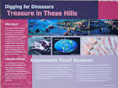
Digging for Dinosaurs: Treasure in These Hills
Why Here?
The Kaiparowits Formation's stunning fossil record results from
a perfect combination of circumstances.
First, during the Late Cretaceous, this region was a lush,
subtropical, coastal plain where an enormous number and variety of
animals lived.
Second, abundant rivers and coastal storms moved great volumes of sand and mud,
so animals that died were sometimes buried quickly, preserving their remains.
Lastly, uplifting of the Colorado Plateau over the past
60 million years has brought this deeply buried treasure to the surface.
Scientific Frontier
In a region famed for once being the last unmapped frontier
in the continental United States,
the Kaiparowits Formation remains a largely unexplored frontier.
By protecting the fossils of this formation
through proper collection and study,
Grand Staircase - Escalante National Monument
conserves a vast storehouse of knowledge available nowhere else on earth.
Kaiparowits Fossil Bonanza
There's treasure beneath your feet.
Not of the gold-and-rubies variety,
but rather a treasure of fossilized bones, eggshells,
and other paleontological gems,
buried in these gray rock formations
some 73-77 million years ago.
Known as the Kaiparowits Formation,
these sedimentary rock layers lie at the top of what is perhaps the
best and most continuous record of Late Cretaceous terrestrial life in the world.
Forty-foot long crocodiles,
rhinoceros-like horned dinosaurs.
tyrannosaurs, and velociraptors – all lived here.
Scientists have surveyed only a small fraction of the Kaiparowits Formation,
and have unearthed more than one hundred species of vertebrates.
Excavations are revealing a long-lost ecosystem inhabited by a
fantastic array of animals,
including some of the earliest marsupial and placental mammals ever found.
These disoveries are helping to explain the origins of our present world.
|
|
|
Other articles:
• Field Notes:
8-Jun-08 on UT Hwy 12;
 View of the cliffs at Bryce Canyon National Park. View of the cliffs at Bryce Canyon National Park.
|
View of Bryce Canyon National Park from view point.
|
|
|
Summit, 7600 feet.
|
|
Literature Cited:
- Retallack, Gregory J., 2009.
|
Near this location, just below the summit is a paleosol collection site in the Upper Cretaceous Kaiparowits Formation used by Retallack in his 2009 study of greenhouse crises of the past 300 million years. The location is described as "The Blues." Retallack used stomatal index data for fossil Ginko and related leaves as a proxy for past CO2 spikes and paleosol chemical data as proxies for temperature and humidity changes. These data show that global warming due to CO2 rise is a not a unique event in earth history and that the magnitude of the coming anthropogenic greenhouse pales in comparison with past greenhouse spikes at times of global mass extinctions.
|
|
Literature Cited:
- Retallack, Gregory J., 2009.
Locations:
Henrieville.
|
Henrieville
Near this location is a paleosol collection site used by Retallack in his 2009 study of greenhouse crises of the past 300 million years. Retallack used stomatal index data for fossil Ginko and related leaves as a proxy for past CO2 spikes and paleosol chemical data as proxies for temperature and humidity changes. These data show that global warming due to CO2 rise is a not a unique event in earth history and that the magnitude of the coming anthropogenic greenhouse pales in comparison with past greenhouse spikes at times of global mass extinctions.
|
|
Other articles:
• Cottonwood Canyon Road:
at Cannonville;
|
Junction: Cottonwood Canyon Road, to Kodachrome Basin State Park and Grosvenor Arch, then south through Cad's Crotch to US Highway 89.
|
|
|
Cannonville
|
|
|
Tropic
|
|
Other articles:
• Field Notes:
8 Oct 2017;
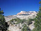
 Powell Point from the roadside near Tropic Powell Point from the roadside near Tropic
|
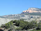
View of Powell Point to the east.
|
|
|
Bryce Canyon National Park below
|
|
|
Bryce Canyon National Park above
|
|
|
Junction: Utah Highway 63, south into Bryce Canyon National Park.
|
|
Tunnel
| |
|
Tunnel
| |
|
Red Canyon Visitor Center
| |
Other articles:
• U. S. Hwy 89:
at UT Hwy 12;
|
Junction: Utah Highway 89,- North to Panguitch.
- South, to many places.
|
If you have a question or a comment you may write to me at:
tas4@schweich.com
I sometimes post interesting questions in my FAQ, but I never disclose your full name or address.
|
[Home Page] [Site Map]
Date and time this article was prepared:
5/10/2024 11:11:47 AM
|
| |
 Eastern Mojave Vegetation