Eastern Mojave Vegetation
Tom Schweich
|
Eastern Mojave Vegetation
| US Highway 285 |
|
Tom Schweich |

|
Denver, Colorado, to Sanderson, TX | ||||||||||||||||||||||||||||||||||||||||||||||||||||||||||||||||||||||||||||||||||||||||||||||||||||||||||||||||||||||||||||||||||||||||||||||||||||||||||||||||||||||||||||||||||||||||
|
Other articles:
|
Junction: US Interstate 25 | ||||||||||||||||||||||||||||||||||||||||||||||||||||||||||||||||||||||||||||||||||||||||||||||||||||||||||||||||||||||||||||||||||||||||||||||||||||||||||||||||||||||||||||||||||||||||
|
Other articles:
|
Junction: US Highway 85, "Santa Fe Road" | ||||||||||||||||||||||||||||||||||||||||||||||||||||||||||||||||||||||||||||||||||||||||||||||||||||||||||||||||||||||||||||||||||||||||||||||||||||||||||||||||||||||||||||||||||||||||
|
Other articles:
|
Junction: Colorado Highway 121 “Wadsworth” | ||||||||||||||||||||||||||||||||||||||||||||||||||||||||||||||||||||||||||||||||||||||||||||||||||||||||||||||||||||||||||||||||||||||||||||||||||||||||||||||||||||||||||||||||||||||||
|
Other articles:
|
Junction: Kipling, in one of its various forms. | ||||||||||||||||||||||||||||||||||||||||||||||||||||||||||||||||||||||||||||||||||||||||||||||||||||||||||||||||||||||||||||||||||||||||||||||||||||||||||||||||||||||||||||||||||||||||
|
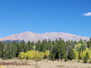
Locations: Mount Carbon. |
Mount Carbon | ||||||||||||||||||||||||||||||||||||||||||||||||||||||||||||||||||||||||||||||||||||||||||||||||||||||||||||||||||||||||||||||||||||||||||||||||||||||||||||||||||||||||||||||||||||||||
|
Junction: Simms Street
Other articles:
Other articles:
Other articles:
Other articles:
Other articles:
Locations:
Meyer Ranch Park.
Other articles:
Other articles:
Other articles:
Locations:
Pine Junction.
Other articles:
Other articles:
Other articles:
Locations:
Harold D. Roberts Tunnel.
Other articles:
Locations:
Kenosha Pass.
Other articles:
Other articles:
Junction: Park County Road 77 “Tarryall Road,” generally southeast to US Highway 24 at Lake George. A good road and pretty drive, just don't be in a hurry.
Locations:
Jefferson.
Other articles:
Other articles:
Locations:
Fairplay.
Other articles:
Other articles:
Junction: County Road 5, southwest to County Road 22 “Weston Pass Road ”
Junction: Park County Road 24, east across South Park.
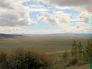
Locations:
South Park.
Cross South Fork of South Platte River.
From here, the river flows south to Antero Reservoir.
Other articles:
Junction: Park County Road 22 west in the direction of Weston Pass.
Locations:
Salt Works Ranch.
Salt Works Ranch to the east between the two hills.
Locations:
Salt Creek.
Cross Salt Creek
Other articles:
Junction: Forest Road 435 “Salt Creek Road”
Other articles:
Other articles:
Other articles:
Locations:
Trout Creek Pass.
The Otero Pipeline, also known as the Homestake Delivery Pipeline, passes west to east through Trout Creek Pass. The water comes from the Homestake Diversion System in the Eagle River basin, and through the Homestake Tunnel into the Arkansas River. The water is pumped out of the Arkansas River by the Otero Pumping Station. Half of the water belongs to the City of Aurora and is delivered to Spinney Mountain Reservoir by the Homestake Delivery Pipeline. The other half of the water belongs to Colorado Springs and continues in the pipeline to Homestate Reservoir.
Other articles:
Locations:
Chubb Park.
Chubb Park below the highway.
Other articles:
Junction: Forest Road 309, northwest the length of Chubb Park.
Other articles:
Other articles:
Other articles:
Locations:
Poncha Springs.
Other articles:
Locations:
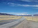
Poncha Pass.
Literature Cited:
Locations:
Carr Gulch.
To the east is Carr Gulch, one of two places mentioned by Hurtado & Gallen (2025) in their study of deglaciation rebound of the Sangre de Cristo Mountains.
Other articles:
Junction: Saguache County Road LL56 “Bonanza Road”
Cross Kerber Creek
County Rd 56LL
Other articles:
Locations:
Villa Grove.
Literature Cited:
Other articles:
Junction: Colorado Highway 17, south across San Luis Valley to Alamosa. Also gives immediate access to County Road GG, east to Valley View Hot Springs and Major Creek (See Hurtado & Gallen, 2025).
Allen Street, San Luis (Street)
County Road 58EE
Locations:
Saguache.
Other articles:
Junction: Colorado State Route 114, over the continental divide and the Cochetopa Hills to US Highway 50, near Gunnison.
Other articles:
Locations:
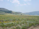
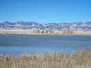
Russell Lakes State Wildlife Area.
Other articles:
Other articles:
Other articles:
Other articles:
Locations:
Rio Grande.
Other articles:
Locations:
Monte Vista.
Rio Grande County above
Junction: N CR 6E, S CR 102
Other articles:
Locations:
Alamosa.
Other articles:
Locations:
La Jara.
Other articles:
Junction: Colorado Highway 142, to Romeo, Manassa, and San Luis.
Locations:
Antonito.
Junction: County Road G
Other articles:
Other articles:
Other articles:
Other articles:
Junction: US Highway 84, north to Pagosa Springs, CO.
Other articles:
Junction:
Exit 183, access to frontage roads.
Junction: NM State Road 503, west then north to Chimayo.
Other articles:
Junction: NM State Road 502, west to Los Alamos.
Junction: Guadalupe Street
Intersection: Alamo Drive
Intesection: Paseo de Peralta
Intersection: Alameda Street
Locations:
Santa Fe River.
Cross the Santa Fe River.
Locations:
Santa Fe.
Other articles:
Date and time this article was prepared:
5/12/2025 2:59:09 PM
|