 Front Range, Eastern Slope, Rocky Mountains
Tom Schweich
|
Front Range, Eastern Slope, Rocky Mountains
| Checklist Flora of Native and Naturalized Vascular Plants of Golden and Vicinity, Jefferson County, Colorado |
|
|
Tom Schweich |

Topics in this Article: Introduction Geography History of Botanic Exploration and Publication Useful Publications Methods Results Discussion - Native Plants Discussion - Non-Native Plants Conclusion Acknowledgements Literature Cited Appendices |
Golden, Colorado sits in a valley formed by erosion along the Golden fault, the geotectonic boundary between the North American Cordillera and the Great Plains. Somewhat like Mono Lake, for which I have also prepared a checklist flora, it sits at a boundary, or perhaps ecotone. Things are always more interesting at the boundaries. I started this project when I realized no such list had been prepared for my newly adopted city. I hope you find this checklist flora helpful. Please write to me if you have questions or comments. | ||||||||||||||||||||||||||
|
|
Introduction | ||||||||||||||||||||||||||
| |||||||||||||||||||||||||||
|
It is probably fair to ask why one would prepare a local flora.
There are many sources of information about plant names, their descriptions, and how to identify them. There are numerous published floras for the whole state of Colorado, Colorado east slope and west slope, and the Intermountain Region, not to mention the less-scholarly wildflower books. The various data bases will permit preparation of plant lists for a location, or a range of geographic coordinates, will also giving link to further web sites such as Flora of North America (FNANM) an Encyclopedia of Life. These are all excellent resources. I used them all myself in the preparation of this flora. Data base lists selected by geographic coordinates, and those selected by named localities, were used to provide an initial list of collections. The published floras of larger regions were used to check on names, descriptions, and distribution. However, the editing process of reviewing collections, and reviewing the absence of collections, provides the benefits that come from preparing a local flora:
| |||||||||||||||||||||||||||
|
Literature Cited:
|
When I started this project I attempted to follow the nomenclature of the Flora of North America (1993+).
When a plant name was found in a published volume of FNANM, I used it.
In the case of unpublished volumes of FNANM, I generally reviewed multiple sources, starting with Ackerfield (2015), the Plant List (http://www.theplantlist.org/), USDA Plants, the Jepson Manual, Weber and Wittmann (2012), and Harrington (1954), and then picked a modern name in common usage. However, over time, I began to follow Plants of the World (POWO, 2022) as it seemed to the most broad and up-to-date coverage. Plants of the World also connects to the historical literature through IPNI - International Plant Names Index and the Biodiversity Heritage Library. Once a name is selected, different names given in Ackerfield (2015, 2022 2nd ed.), Weber and Wittmann (2012), or Harrington (1954), are listed as synonyms. | ||||||||||||||||||||||||||
|
|
Geography | ||||||||||||||||||||||||||
|
|
Golden City Limits | ||||||||||||||||||||||||||
|
Other articles:
Locations:
Eagle Ridge.
Fossil Trace Golf Club.
Golden.
Tony Grampsas Memorial Sports Complex.
|
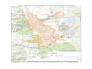
The boundaries of incorporated Golden are quite irregular. They stretch from I-70 on the south to north of Golden Gate Canyon on the north. The western boundary includes significant portions of the slopes of Lookout Mountain, but do not extend to a ridge line or natural boundary for the purposes of this flora. On the east side, the Coors Technology Center comprises a large isolated incorporated area north of 44th and west of MacIntyre. This results in incorporated Golden on the east and west sides of North Table Mountain, but the mountain itself is not part of the City of Golden. Only a small part of South Table Mountain is within the City of Golden. Pleasant Valley is unincorporated Jeferson County, but there are irregular sections, including a business park south of 6th and east of Indiana.
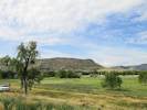
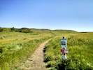
Within the City of Golden, there are a few parcels that are city-owned, and large enough to be collected. The Fossil Trace Golf Course occupies 216 ac. (87 ha.). It is not really a hotbed of biodiversity, but the elk like to hang out there in the winter. City-owned open space on the west and south slopes of North Table Mountain comprises 135 ac. (54 ha.). Eagle Ridge is the third largest parcel at 79 ac. (32 ha.) and the Grampsas Sport Complex contains 58 ac. (24 ha.). There is a small hilly parcel near the top of Washington Avenue of 4 ac. (1.6 ha.). This last parcel is perhaps the most interesting as it contains a relatively intact small (1.5 ac.) remnant mixed-grass prairie on the top of the hill. | ||||||||||||||||||||||||||
|
|
Golden sensu latu (s.l.) | ||||||||||||||||||||||||||
|
Locations:
Golden.
|
In describing “Golden” in the broad sense, I have attempted to smooth the boundaries of the incorporated City of Golden, look for natural boundaries, and avoid development encroaching on open space, e.g., north slope of North Table Mountain. | ||||||||||||||||||||||||||
|
Other articles:
|
From the northwest corner of Golden on Pine Ridge Road, the boundary curves across the undeveloped slopes of North Table Mountain to the business park at 44th and McIntyre. | ||||||||||||||||||||||||||
|
Other articles:
|
The eastern boundary is along McIntyre Street, jogging west to avoid the Rolling Hills Country Club and former Camp George West. There is an easward extension to include the little piece of Golden at 6th and Indiana. | ||||||||||||||||||||||||||
|
Other articles:
Locations: Apex Park. Tin Cup Ridge. |
The south boundary is the lower northwest slopes of Green Mountain, i.e., Green Mountain is excluded, I then follow Interstate 70, and a ridge line separating the incorporated area of Golden from Mount Vernon Canyon. Both Tin Cup Ridge and Apex Open Space Park are therefore included within Golden s.l. | ||||||||||||||||||||||||||
|
Locations: Lookout Mountain. Mount Zion. |
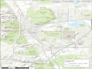
The western boundary begins where the ridge line intersects the western edge of the Morrison quadrangle, and the boundary of Golden s.l. is the easternmost of either the quadrangle boundary or the ridge line of Lookout Mountain and Mount Zion. From Mount Zion back to Pine Ridge Road, I basically draw a straight line along the various western extents of the irregular Golden city limits. | ||||||||||||||||||||||||||
| The definition of Golden s. l. includes much of the southwest corner of the Golden quadrangle and the northwest corner of the Morrison quadrangle. The Evergreen and Ralston Buttes quadrangles do not include any portion of Golden s. l. as I have defined it. | |||||||||||||||||||||||||||
|
|
North Table Mountain | ||||||||||||||||||||||||||
|
Literature Cited:
Other articles:
Locations: North Table Mountain. Ralston Dike. |
| ||||||||||||||||||||||||||
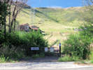
| Nearly all North Table Mountain is in public ownership. The largest part, about 1,873 acres, is owned by Jefferson County, and managed by Jefferson County Open Space as North Table Mountain Park. This park is very popular and heavily used all year around. A smaller portion, about 135 acres on the southwest slopes, is owned by the City of Golden. The radio tower is on a 1-acre privately-owned parcel. | |||||||||||||||||||||||||||
| There are six developed trailheads permitting access to North Table Mountain, and several undeveloped, or social, trailheads. | |||||||||||||||||||||||||||
|
Other articles:
Locations:
North Table Mountain.
|
| ||||||||||||||||||||||||||
|
Other articles:
Locations:
North Table Mountain Park.
|
| ||||||||||||||||||||||||||
|
Other articles:
Locations:
North Table Mountain Park.
|
There is an access point on W. 53rd Drive, but no parking nearby. | ||||||||||||||||||||||||||
|
Other articles:
|
There may be a trailhead from the Table Rock subdivision. In fact, maps of North Table Mountain Park, show this as an Access Point. The problem is: getting back into the subdivision from the park requires passing a "No Trespassing" sign. | ||||||||||||||||||||||||||
|
Other articles:
|
The City of Golden has a trailhead into their lands on North Table Mountain on Peery Drive. This trailhead gives access to the City of Golden North Table Mountain trail. | ||||||||||||||||||||||||||
|
Other articles:
|
There are two commonly used social trails leading to North Table Mountain One is off Dunraven Circle in Table Rock. The other is at Easley Road and Colorado Highway 58. The Dunraven Circle social trail is quite handy. Short, only 160 meters in length, it gives easy access to the North Table Loop, and then there is only another 245 meters to the Mesa Top Trail. It is, of course, signed “No Trespassing.” In theory, there is an access point to the Tablerock Trail from Tablerock Subdivision about 430 m. to the northeast. This access point can accessed from either Dunraven Circle or Devil's Head Circle by way of a concrete multiuse trail. Unfortunately, that trail is also signed “No Trespassing.” | ||||||||||||||||||||||||||
|
Other articles:
|
The Easley Road social trail begins near the Easley Road on-ramp to Colorado Highway 58 West. It is a little obscure to find. The trail climbs steeply to the fourth terrace in the road cut above Highway 58. The trail follows the terrace to its end, and then begins to climb a small canyon of North Table Mountain, following the route of an old road. This road is shown on the 1939 edition of the USGS Golden, Colo. 7.5" quadrangle map. The distance to the North Table Loop is about a half mile. | ||||||||||||||||||||||||||
|
Literature Cited:
|
There have been several Colorado Native Plant Society (CoNPS) field trips on North Table Mountain. Two that are listed on the society's web site are: May 14, 1994, led by Sally White and Loraine Yeatts, and May 23, 1998, led by Paul Kilburn and Jerry Duncan. There is a plant list available from the White and Yeatts field trip.
The author led Colorado Native Plant Society field trips to North Table Mountain in 2016, 2017, and 2019. The plant lists from those field trips are kept constantly up to date by this web site. See Plant Check List for North Table Mountain, Jefferson County, United States. | ||||||||||||||||||||||||||
|
|
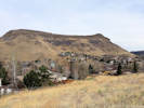
South Table Mountain | ||||||||||||||||||||||||||
|
Locations: South Table Mountain. |
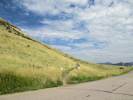
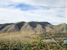
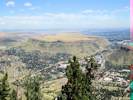
Seen from a distance, it is clear the upper surface South Table Mountain is a continuation of the upper surface of North Table Mountain. | ||||||||||||||||||||||||||
| Ownership of South Table Mountain is more mixed than North Table Mountain. The three largest owners are Jefferson County (738 Ac.), State of Colorado (500 ac.), and Bear Creek Development (312 ac.). The City of Golden owns a small 31-acre parcel where the Lubahn Trail is found. | |||||||||||||||||||||||||||
|
Other articles:
|
There are three developed trailheads with parking, two access points without parking, and three more informal, or social, access points. | ||||||||||||||||||||||||||
|
Other articles:
Locations:
South Table Mountain.
|
| ||||||||||||||||||||||||||
Neighborhood access without parking is at:
| |||||||||||||||||||||||||||
|
Other articles:
|
| ||||||||||||||||||||||||||
|
Other articles:
|
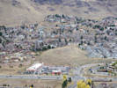
Lookout Mountain | ||||||||||||||||||||||||||
|
Other articles:
Locations:
Apex Park.
Lookout Mountain.
Matthews/Winters Park.
Windy Saddle Park.
|
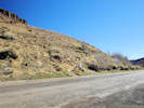
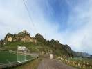
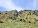
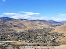
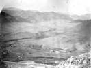
Lookout Mountain is the very eastern edge of the Rocky Mountain Front Range. The Front Range runs north-south between Casper, Wyoming and Pueblo, Colorado and rises nearly 10,000 feet above the Great Plains. Longs Peak, Mount Evans, and Pikes Peak are its most prominent peaks, visible from the Interstate 25 corridor. The highest mountain peak in the Front Range is Grays Peak. Other notable mountains include Torreys Peak and Mount Bierstadt.
Only the eastern-facing slopes of Lookout Mountain are covered by this checklist flora. Land ownership (1,221 ac.) is primarily Jefferson County Open Space for Windy Saddle Park, Apex Open Space Park, Lookout Mountain Nature Center, and small portion of Matthews/Winters Park. Denver Parks owns a large parcel (69 ac.) on top of Lookout Mountain. Martin Marietta is the largest private landowner for their quarry, followed by the Missionary Sisters of the Sacred Heart (Mother Cabrini Shrine). | ||||||||||||||||||||||||||
|
Other articles:
Locations:
Colorado School of Mines Survey Field.
|
Colorado School of Mines Survey FieldThe next largest single parcel is the Colorado School of Mines Survey Field. It consists of 2 parcels totaling about 226 acres. At the upper, west side, it abuts Lookout Mountain. Though owned by a public agency, the Survey Field is not really open to the public, in the sense of a public park or open space. The school needs to know who in on their property, and to cover themselves for liability issues. The Survey Field has been disturbed by roads, mining, and utilities. It is also quite weedy in places. Regardless, it is a unique piece of open space in Golden, given its size, and its place between Golden and Lookout Mountain. | ||||||||||||||||||||||||||
|
Other articles:
|
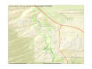
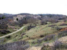
Kinney Run / Deadman GulchThe City of Golden-owned parcels in the vicinity of Eagle Ridge (a small hogback), Deadman Gulch, Kinney Run, and Heritage Dells comprise about 90 acres. There are also some city-owned watercourses near the south-west end of those shown on this map. | ||||||||||||||||||||||||||
|
Literature Cited:
Other articles:
Locations: Deadman Gulch. Eagle Ridge. Heritage Dells. Kinney Run. |
Of the four names applied to this area, only two: Deadman Gulch and Heritage Dells, are recognized by the U.S. Board on Geographic Names (BGN, n.d.). The source for “Kinney Run” is unknown, but is probably a euphemism used by developers for Deadman Gulch. The original source may be “Kenneys Creek” found on the 1938 Morrison quadrangle applied to a creek flowing north along present-day Johnson Avenue, then northwest along South Golden Road. Similarly, the source for “Eagle Ridge” is also unknown, but was probably chosen by real estate developers in the area.
| ||||||||||||||||||||||||||
|
Locations: Deadman Gulch. Eagle Ridge. |
The largest parcels are in the north between Tripp Ranch and US Highway 6. The northernmost parcel sits between the Survey Field and US Highway 6, spanning Deadman Gulch, and including a small hogback that may be the source of the name “Eagle Ridge.” Collecting in this area has been an extension of collecting in the Survey Field. There are no collections from the ridge itself, although the southern end of the ridge is getting close to the Handsford T. Shacklette collections. These were made near the intersection of US Highway 6 and Heritage Road (June 27, 1959. 25 vouchers, COLO, and 1 voucher, MICH). | ||||||||||||||||||||||||||
|
Other articles:
Locations:
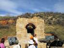
Cambria Lime Kiln.
Kinney Run.
|
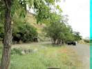
South and west of Eagle Ridge is the heart of Deadman Gulch/Kinney Run. A little over 31 acres, this parcel is oriented north-south, and fairly narrow from east to west.
| ||||||||||||||||||||||||||
|
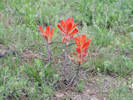
The vegetation of Kinney Run is a mosaic of Foothills Shrubland and Riparian, with some remnant Mixed-Grass Prairie. Despite the extensive disturbance and planting of non-natives, many native grasses and forbs (non-woody perennials) can still be found in Kinney Run. Roundtip Twinpod (Physaria vitulifera) and Front Range Beardtongue (Penstemon virens) bloom in the spring on the rock outcrops of the Lyons Sandstone along with Mountain Mahogany (Cercocarpus montanus). Green Needlegrass (Nassella viridula) and Needle and Thread (Hesperostipa comata) are found around the edges of the Chokecherry (Prunus virginiana) thickets below the cliffs. The wetter areas near the creek support both Golden Currant (Ribes aureum) and Wax Currant (R. cereum), along with Wild Bergamot (Monarda fistulosa) and the Cloaked Bulrush (Scirpus pallidus). The drier slopes opposite Eagle Ridge support many examples of remnant Prairie vegetation, such as Prairie Groundsel (Packera plattensis), Cowboy Delight (Sphaeralcea coccinea), and Blanketflower (Gaillardia aristata). | |||||||||||||||||||||||||||
|
Literature Cited:
Locations: Kinney Run. Letters: Thursday, August 9, 2018. |
Golden GiddyUp (2017-2018) proposed to build a system of dirt bicycle trails in the Kinney Run/Heritage Dells area, including one through this parcel. The trail was proposed to be some distance away from the existing Kinney Run trail. It would therefore further fragment this small area into three pieces from its current two pieces. This proposal was strongly opposed by the Friends of Kinney Run, and by the author. This proposal has been withdrawn, for now, in favor of a bicycle trail linking Beverly Heights to Kinney Run, by way of the Survey Field. | ||||||||||||||||||||||||||
| Between Tripp Ranch and Heritage Dells Park lies a small parcel of 7.8 acres. This parcel goes from the riparian zone of Kinney Run east to the back fences of the houses that face Somerset Street. | |||||||||||||||||||||||||||
|
Other articles:
|
At the south end of this parcel, there was formerly a social trail from the end of W. 4th Avenue down to the Kinney Run Trail. Presumably this trail was used by children enroute to Shelton School. The trail is faintly visible on GoogleEarth imagery from 1999, before the concrete trail was constructed to the south. The social trail has since been revegetated (2015 to 2017). | ||||||||||||||||||||||||||
| Heritage Dells Park is accessible from Crawford Street. In 1987, this foothills park was built to serve the Heritage Dells Subdivision. Currently, it is located at the midpoint of the Kinney Run Trail, and makes for a great resting place along this regional trail that begins at Heritage Square. The terrain is hilly and its a good push to get a loaded baby stroller back to the car from the A.D.A. accessible playground. A basketball court is also available at the park, perfect for neighborhood pick-up games and practice. Includes a cherry stem southward to Kimball Avenue. | |||||||||||||||||||||||||||
|
Locations: Heritage Dells. |
The location of GNIS Heritage Dells. Roughly at the corner of Kimball Avenue and Crawford Circle. | ||||||||||||||||||||||||||
| The Kinney Run trail continues south through a narrow corridor to Apex Park (Jefferson County Open Space) and its many trails. It passes by the Magic Mountain archeological site. | |||||||||||||||||||||||||||
|
Literature Cited:
Locations: Magic Mountain. |
Magic Mountain archeological site: Named for a nearby amusement park now known as Heritage Square, the Magic Mountain Archaeological Site south of Golden was excavated in 195960 by Cynthia and Henry Irwin. Because it was one of the first foothills sites to be professionally excavated, the Irwins report on Magic Mountain has provided the foundation for all later archaeological research in the region. In the 1990s new excavations discovered thousands of artifacts and bone fragments as well as several architectural features, which have helped provide more precise dates and cultural affiliations for the site. Vegetation in the vicinity of the Magic Mountain archeological site was surveyed by Ernest H. Brunquist (1966). | ||||||||||||||||||||||||||
|
Other articles:
Locations:
Tin Cup Ridge.
|
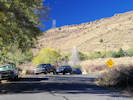
Tin Cup RidgeTin Cup Ridge is the northward extension of Dinosaur Ridge into Golden. Interstate 70 cuts through Dinosaur Ridge and separates the two parts of the ridge. The easiest way to access Tin Cup Ridge is from the Rooney Road Sports Complex. At the south end, Tin Cup Ridge can also be accessed from the T-Rex Park and Ride Lot. And, for the truly intrepid, it is possible to access Tin Cup Ridge from the north, through the Wrigley's Chicago Bar & Grill parking lot from the intersection of Colfax Avenue and Zeta Street. It was necessary to use this entrance when the Rooney Road Sports Complex was closed because of the COVID-19 pandemic. | ||||||||||||||||||||||||||
|
Locations: Matthews/Winters Park. |
Matthews/Winters ParkThere is a small portion of Matthews/Winters Park that is north of Interstate 70, and just south of the Golden city limits. This area is not open to the public. | ||||||||||||||||||||||||||
|
Other articles:
Locations:
Apex Park.
Apex Park - Northern Parcel.
Deadman Gulch.
|
Apex ParkApex Park is about 700 acres. Of those, about 500 acres are within the City of Golden. The larger southern portion of the park is heavily used and a popular destination for hiking and mountain biking. There is a smaller northern portion of the park that is closed for resource protection. There is one trailhead and two other access points to Apex Park. The trailhead is on Heritage Road near Colfax Avenue. The access points are on Lookout Mountain Road and Poco Calle Road. They have minimal parking and no facilities. Some clever map-reading will disclose other ways to enter Apex Park. However, doing so is difficult without crossing private property or inadvertently entering the restricted area. | ||||||||||||||||||||||||||
|
Other articles:
Locations: Tony Grampsas Memorial Sports Complex. |
Tony Grampsas Memorial Sports ComplexThe Tony Grampsas Memorial Sports Complex comprises 58 acres, almost entirely developed. | ||||||||||||||||||||||||||
|
Other articles:
Locations: Landing Zone. |
CSM Paraglider Landing AreaThe hang glider landing field is 45 acres, property owned by Colorado School of Mines, a lot of it disturbed by use. To the south of the landing field is a small City of Golden parcel of about 14 acres. | ||||||||||||||||||||||||||
|
Literature Cited:
Locations: Cressmans Gulch (lower). |
Dakota Ridge and Cressman GulchThe south end of Dakota Ridge and the adjacent Cressman Gulch is in the very northern part of Golden. I have applied the name Dakota Ridge to this hogback because that is the only name I have seen applied to it. The name was applied by Van Horn (1957) in Bedrock Geology of the Golden Quadrangle. “Dakota Ridge” is also sometimes applied to the corresponding hogback south of Golden. However the GNIS (BGN, 2019) applies the name “Dinosaur Ridge.” Regardless of the naming question, Cressman Gulch and the Dakota Ridge hogback above it measure to be 39 acres. The eastern portion, about 13 acres by my estimate and therefore quite unofficial, is likely to be used for the relocation of Colorado Highway 93 sometime in the future. The remaining 26 acres is primarily contributed by the south end of the hogback. There are open mines on the hogback, which are fenced, and not open to access by the public. | ||||||||||||||||||||||||||
|
Literature Cited:
Other articles:
Locations: Dakota Ridge. Rocky Flats. White Ranch Park. |
There is no historic botanic data for Dakota Ridge. The author made about 54 collections in 2020, and combined with additional observations, there are 86 plant species known from the ridge and adjacent gulch. One collection is of particular interest. It is Linaria canadensis (L.) Dum.-Cours. Var. texana (Scheele) Pennell, with a common name of “Blue Toadflax.” A commonly used synonym for this plant is Nuttallanthus texanus (Scheele) D. A. Sutton. This name was proposed by Sutton (1988) to separate the new world Linaria from the old world Linaria. However, recent phylogenetic work (Fernandez-Mazuecos, et al., 2013) shows that the new world plants need to be retained in the old world genus Linaria. There is historic collection made along the railroad tracks in Golden from more than a century ago. More recently, it was collected at Rocky Flats and White Ranch.
| ||||||||||||||||||||||||||
|
Locations: Tucker Gulch (lower). |
Tucker GulchTucker Gulch and the lower part of Cressman Gulch, i.e., south and east of Colorado Highway 93, form a kind of linear open space, if the term “open space” can be applied to a long narrow shape. While much of the lower part of Tucker Gulch is still railroad right of way, the portion owned by the City of Golden is 34 acres. Tucker Gulch between the highway and Clear Creek is about 3.2 km. in length, and Cressman Gulch from the highway to the mouth at Tucker Gulch is about 1.5 km. in length. When combined with the railroad land, the width varies from a minimum of 17 m. to a maximum of 109 m., although generally the width is about 30 to 50 m. | ||||||||||||||||||||||||||
|
Other articles:
|
The vegetation in Tucker Gulch is quite weedy. There are only a few collections made in Tucker Gulch and of them only one is native: Heterotheca villosa “Hairy False Goldenaster.” Among the non-native plants, one, Alopecurus arundinaceus “Creeping Meadow Foxtail” is an uncommon grass in Jefferson County, and therefore at least mildly interesting. | ||||||||||||||||||||||||||
|
Other articles:
Locations:
Schweich Hill.
|
Schweich HillThe little piece of City of Golden open space at the north end of Washington Avenue, near Cannonball Creek Brewery, measures 4 acres. Tracts A & B of the parcel was accepted by the City of Golden by Resolution No. 516, adopted December 23, 1993. Both tracts are dedicated as open space, although Tract B was also dedicated for W470 expansion.
| ||||||||||||||||||||||||||
|
Other articles:
|
Feld trips sponsored by Colorado Native Plant Society visited the open space parcel in 2018 and again in 2022. | ||||||||||||||||||||||||||
|
Other articles:
|
There are 136 taxa (species of plants) in 42 plant families, mostly grasses and forbs (non-woody perennials). None of the plants collected or observed are Colorado-ranked rare plants (Colorado Natural Heritage Program, 1997+). There are 13 species of Colorado-listed Noxious Weeds (Colorado Department of Agriculture, 2014-2019). There is one species on List A, Euphorbia myrsinites L. Myrtle Spurge, and seven List B species. At least one species of noxious weed, Dipsacus laciniata, has not been seen for several years due to repeated weeding. | ||||||||||||||||||||||||||
|
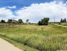
A small portion covering the top of the hill, about 1.5 acres in size, could be identified as Western Great Plains Foothill and Piedmont Grassland with mixed tall and short grass species. Significantly sized other portions, would be identified as Smooth Brome (Bromus inermis Leyss) Ruderal Vegetation. | |||||||||||||||||||||||||||
|
There is substantial disturbance around the edges of the parcel. Disturbance includes grading, water lines or other utilities, construction, landscaping or revegetation, yard debris disposal and mowing by neighbors, and social trails and amenities. It is unclear when the water line was placed across the parcel, but the current vault appears in 7/4/2005 imagery. The center of the open space is less-disturbed, where the primary disturbances are social trails and amenities. | |||||||||||||||||||||||||||
|
There are four easily identifiable social trails crossing all or part of the parcels. The primary social trail crosses the parcels east to west across the top of the hill. This trail bisects the area of remnant native vegetation on the top of the hill and is frequently used by hikers, dog walkers, and by a few mountain bikes. The opportunities for rerouting this trail away from the native vegetation, while still permitting access to the top of the hill, seem quite limited. The trail is eroding on the stepest slope at the eastern slope of the hill. There is one social amenity, i.e., a bench near the top of the hill. The bench and associated access trail first appear in 10/7/2012 imagery. The access trail to this bench passes perilously close to several individual plants of Missouri Foxtail Cactus. | |||||||||||||||||||||||||||
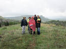
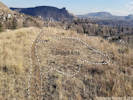 Trampled area beside social trail. Trampled area beside social trail.
|
The top of the hill is occasionally used for picnics or similar activities as evidenced from a rather large trampled area. I have even encountered a wedding photography party on top to the hill. Unfortunately, the trampled area is at the center of the best native vegetation. This causes damage to the small area of native prairie and indicates why the trail needs to be signed with a plea for users to remain on the trail. | ||||||||||||||||||||||||||
|
I keep a separate report about this open space, which can be found on my home page with a title of “Botanical Resources of Schweich Hill, Golden, Colorado.” | |||||||||||||||||||||||||||
|
|
Nearby Areas Excluded | ||||||||||||||||||||||||||
| Any developed areas on the north slope of North Table Mountain are excluded, e.g., the Table Rock subdivision. | |||||||||||||||||||||||||||
| The boundary was drawn to swing west of the Rolling Hills Country Club. | |||||||||||||||||||||||||||
| The former Camp George West is excluded in its entirety. | |||||||||||||||||||||||||||
|
Literature Cited:
Locations: Green Mountain. |
Nearly all of Green Mountain is excluded, except for the lowest northwest slopes.
There are a few lists available for Green Mountain. The most recent is Yeatts & Yeatts (2009). | ||||||||||||||||||||||||||
|
|
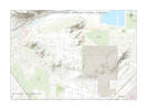
GeologyMy broad definition of Golden is included on two USGS 7.5" topographic maps: Golden and Morrison. | ||||||||||||||||||||||||||
|
Literature Cited:
Locations: Golden. |
Geology of the Golden quadrangle is by Van Horn (1972, 1976). | ||||||||||||||||||||||||||
|
Literature Cited:
Locations: Golden. |
Geology of the Morrison quadrangle is by Scott (1972). | ||||||||||||||||||||||||||
|
Literature Cited:
Locations: Dakota Ridge. Tin Cup Ridge. |
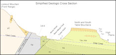
Golden sits roughly in the center of the Rocky Mountain Front. This long, straight, persistent structural boundary originated between 1.4 and 1.1 billion years ago in the Mesoproterozoic Era. It was intruded by the Pikes Peak granite (1.09 billion years) in central Colorado. The Rocky Mountain Front began as a boundary between thick cratonic lithosphere to the east (modern coordinates) and an orogenic plateau to the west and remains so today. The structural boundary was reactivated during the breakup of the supercontinent Rodinia (1.1 to 0.6 billion years ago) and again during deformation associated with formation of both the Ancestral (≈300 Ma) and Laramide (80-40 Ma) Rocky Mountains. The landscape we now see was enhanced during the late Miocene to Holocene (ca. 60 Ma) by tectonic uplift. Increased monsoonal precipitation caused differential erosion along the mountain front, exhuming an imposing 0.5 1.2 km escarpment that is bordered by hogbacks of Mesozoic strata and incised by major river canyons. The hogbacks do not occur in central Golden as they are cut off by the Golden fault. However, there are hogbacks in both north and south Golden s.l., i.e, Dakota Ridge in the north, and Tin Cup Ridge in the south. | ||||||||||||||||||||||||||
|
Literature Cited:
Locations:
Golden.
|
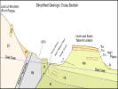
Simplified geologic cross section of Golden and vicinity.
| ||||||||||||||||||||||||||
|
|
Soils | ||||||||||||||||||||||||||
|
Literature Cited:
|
Soils in the Golden area were enumerated in Price and Amen (2001, 2008 rev.). Seventy-nine different soil types are recognized in Golden sensu latu | ||||||||||||||||||||||||||
|
Literature Cited:
Other articles:
Locations: Golden. |
Vegetation of GoldenThere are three basic types of vegetation in Golden s.l.:
I havent used formal names, such as those found in the National Vegetation Classification System (USNVC, 2019), because none of the areas in Golden s.l. have received the formal attention and documentation required for a more formal definition.
Shrubs are represented on the prairie by Ribes cereum (Wax Currant) and Prunus virginiana (Chokecherry). In the watercourses, such as Tucker Gulch and Arapahoe Gulch, is a riparian vegetation consisting of willows and cottonwoods (Salix spp.), with sedges (Carex sp.) and rushes (Juncus sp.), and sometimes cat tails (Typha sp.). Away from the valley bottoms, on the slopes of North and South Table Mountains and Mount Galbraith is a foothill shrubland. These can be very dry and exposed favoring Cercocarpus montanus (Alder-Leaf Mountain Mahogany). A little more mesic habitat favors shrubs such as Rhus trilobata (Squawbush) and Prunus americana (American Plum). The small watercourses may support Acer glabrum (Rocky Mountain Maple) and Physocarpus monogynus (Mountain Ninebark). Of course, the boundaries between these vegetation types are rarely sharp, and representatives of one vegetation type will often be found growing with representatives of another type. | ||||||||||||||||||||||||||
| [Next Page] | |||||||||||||||||||||||||||
| If you have a question or a comment you may write to me at: tas4@schweich.com I sometimes post interesting questions in my FAQ, but I never disclose your full name or address. |
Date and time this article was prepared: 4/27/2024 3:18:56 PM |