
|
From Estes Park to the great plains.
|
|
Other articles:
• US Hwy 40:
near Muddy Pass;
|
Junction: US Highway 40
|
|
Locations:
North Platte River.
|
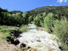
Cross Grizzly Creek
Just downstream is the junction of Grizzly Creek and Little Grizzly Creek, which point is considered to be the headwaters of the North Platte River.
|
|
Locations:
Peterson Ridge.
|
Cross Peterson Ridge
|
|
Other articles:
• County Route 24:
90000;
|
Junction: County Route 24, west in the direction of Buffalo Pass.
|
|
Other articles:
• Colorado State Highway 125:
at CO 14;
|
Junction: Colorado Highway 125, south.
|
|
Other articles:
• Field Notes:
19 Jun 2018 in Walden;
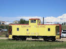 Union Pacific caboose in Walden. Union Pacific caboose in Walden.
|
Union Pacific caboose at the south end of Walden, approximately where the railroad used to run.
|
|
Other articles:
• Colorado State Highway 125:
at 6th;
• Field Notes:
19 Jun 2018;
Locations:
Walden.
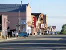 Downtown Walden in the morning. Downtown Walden in the morning.
|
Walden
Junction: Main Street, Colorado Highway 125, north.
|
|
|
Junction: McKinley Street
|
|
|
Junction: Garfield Street
|
|
|
Junction: Harrison Street
|
|
|
Junction: 6th Street
|
|
|
Junction: 7th Street
|
|
|
Junction: County Road 17
|
|
Other articles:
• Field Notes:
19 Jun 2018;
Locations:
Arapaho National Wildlife Refuge.
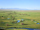 Overview of the Illinois River in the Arapaho National Wildlife Refuge. Overview of the Illinois River in the Arapaho National Wildlife Refuge.
|
Arapaho National Wildlife Refuge.
|
|
|
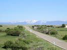
Hustead(?) Ranch
Ranch near Owl Creek.
|
|
Other articles:
• Field Notes:
19 Jun 2018 at Owl Ck;
Locations:
Owl Creek.
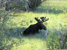 Moose at Owl Creek. Moose at Owl Creek.
|
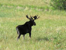
Moose at Owl Creek. |
Where we saw the moose (in the field at left). |
Cross Owl Creek.
|
|
Other articles:
• Cty Rd 27:
at CO 14;
|
Junction: County Road 27, to Rand.
|
|
Other articles:
• Cty Rd 41:
at CO 14;
|
Junction: County Road 41, east into State Forest State Park.
|
|
|
Gould
|
|
|
State Forest State Park
Visitor Center
|
|
Other articles:
• Field Notes:
19 June 2018;
|
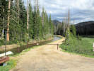
Ranger Lakes
Campground and Nature Trail
|
|
|
Junction: County Road 62, to Willey Lumber Camp.
|
|
Other articles:
• Colorado Trans-Basin Water Transfer:
Upper Michigan Ditch;
• Field Notes:
18 Jun 2018;
19 June 2018;
 View from Colorado Highway 14. View from Colorado Highway 14.
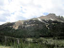 Michigan Ditch on the slopes of the Nokhu Crags. Michigan Ditch on the slopes of the Nokhu Crags.
|
Scenic View Point
|
|
Other articles:
• Colorado Trans-Basin Water Transfer:
Cameron Pass Ditch overview;
• Field Notes:
at Cameron Pass;
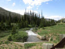
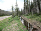 South water-gathering ditch of Cameron Pass Ditch South water-gathering ditch of Cameron Pass Ditch
|
Cameron Pass Ditch to the east of the highway.
|
|
Other articles:
• Colorado Trans-Basin Water Transfer:
Cameron Pass Ditch overview;
• Field Notes:
at Cameron Pass;
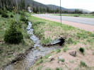 Water-gathering ditches join and cross under the highway in a culvert. Water-gathering ditches join and cross under the highway in a culvert.
|
Gathering ditches join and pass under the highway
|
|
Other articles:
• Colorado Trans-Basin Water Transfer:
Cameron Pass Ditch overview;
• Field Notes:
at Cameron Pass;
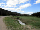 Cameron Pass Ditch transport ditch Cameron Pass Ditch transport ditch
|
Water in the transport ditch across the pass.
|
|
Other articles:
• Colorado Trans-Basin Water Transfer:
Cameron Pass Ditch overview;
Michigan Ditch;
Michigan Ditch;
Michigan Ditch;
• Field Notes:
at Cameron Pass;
Locations:
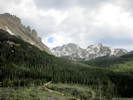
Cameron Pass.
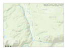
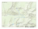 Location of Michigan Ditch, Jackson County, Colorado Location of Michigan Ditch, Jackson County, Colorado
|
Jackson County above
Cameron Pass, 10,249 ft.
The Cameron Pass Ditch and Michigan Ditch, or Upper Michigan Ditch, cross Cameron Pass from south to north, diverting water into Joe Wright Creek from headwater streams of the Michigan River.
Interpretive panel at Cameron Pass. |
Interpretive panel for Forest Conservation. |
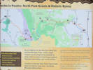
Informational sign for Cache la Poudre - North Park Scenic and Historic Byway. |
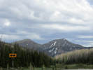
View a little east of south to Lulu Mountain on the right and Thunder Mountain on the left. |
Michigan Ditch approaches Colorado Highway 14. |
The water from Michigan Ditch exits through a gaging station. |
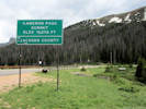
Cameron Pass, Larimer and Jackson Counties, Elevation 10, 276 feet. |
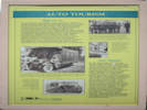
Auto Tourism
|
Highway 14
| |
The first Highway over Cameron Pass,
completed in 1882 but the Cache la Poudre and North Park Toll Road Company,
ran more than one hundred miles from Fort Collins to the silver camp of Teller.
Travelers paid three dollars per wagon,
with additional fees for herd and pack animals,
for the privilege of laboring up a demanding, boulder-strewn route.
Some stretches were so hard to navigate
(especially steep Pingree Hill)
they left teamsters cursing in frustration.
Opened to free public travel in 1902,
the road received much-needed improvements in the 1910s,
with a smoother surface and an easier grade carved out by convict laborers.
When the road reopened in 1915,
two hundred automobiles drive to a celebratory picnic at milepost 109
(about forty miles east of here),
motoring with ease over the once formidable route
— and heralding a new generation of auto tourism.
| |
The Autobungaloofer, seen here in 1921,
epitomized America's craze for auto tourism.
Serene mountain towns cleared trees and shrubs to make room for homes on wheels.
For those who didn't think to bring the house with them,
motels were built,
while Mom and Pop made room for convenience stores,
gift shops,
and bait shops.
| |
As early as 1896 John C. Zimmerman,
with help from his wife and four children,
built their second hotel,
the Keystone.
Most of the construction on the three-story,
forty-room building,
including brickmaking,
was done by hand.
| |
Convicts from the state penitentiary in Cañon City
completed much of the work in the Cache la Poudre and North Park Toll Road.
In 1917 the Rocky Mountain News credited convicts working in the Poudre Canyon
with having completed the most difficult work out of some 145 miles
constructed within the state of Colorado.
| |
By the 1870s,
boom towns Lulu and Teller City,
just west of bustling Fort Collins,
were established and silver excitement was in the air.
The Cache la Poudre and North Park Toll Road
was built to provide smooth passage for trade.
|
Auto Tourism
| |
By 1927 automobiles could drive the Cameron Pass roas all the
way from Fort Collins to Walden
— about a hundred miles.
Toursim soon became a major industry in the Cache la Poudre corridor,
with campgrounds and motor courts lining the valley.
Ironically,
this influx of people compromised the very attractions
— solitude and beauty —
that drew visitors in the first place.
The paradox climaxed in the early 1970s,
when developers proposed a ski area atop Cameron Pass
to lure the Winter Olympics to Colorado.
Local residents joined environmentalists from
across the state to defeat the idea,
but one element of the plan survived
— an asphalt surface for unpaved Highway 14.
That brought still more traffic,
helping the economy
but applying more pressure on the wilderness.
The same trade-off confronts communities throughout Colorado,
representing one of the biggest challenges
of the late twentieth and early twenty-first centuries.
|
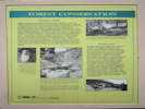
Forest Conservation
|
Pingree Park
During the construction of the transcontinental railroad in the late 1860s,
the timber fell almost continuously in Pingree Park.
Named for the legendary tie-hack George Pingree
(who supposedly could cut a hundred ties a day),
the tree-covered valley about seventeen miles east of here supplied the
Union Pacific with much of its building material.
Overcutting decimated the forests,
and the site lay abandoned from the 1870s until 1912,
when the Agricultural College of Colorado
(later Colorado State University)
acquired the land.
The college, ironically,
transformed this overused resource into a model of wise environmental management.
Pingree Park became an outdoor classroom,
anchoring one of the nation's leading natural resource programs.
Colorado State produced so many U.S. Forest Service
and National Park employees that it was named
“the Ranger Factory”
— a training ground for latter-day George Pingrees
who build forests up rather than chopping them down.
| |
The legendary George Pingree in 1859
— two years before enlisting in the U. S. Army at Central City.
After the Sand Creek Massacre in 1864,
Pingree served a ten-day sentence at Fort Lyon
for scalping thirteen Indians.
He resented his sentence and never regretted his part in the massacre.
| |
In October 1986, Congress passed the
National Wild and Scenic Rivers Act to protect the few unpolluted,
undeveloped rivers in the United States.
Since then, over 10,000 river miles have been protected,
including seventy-five miles of the Cache la Poudre
— the only Colorado river pristine enough to allow designation.
| |
Right:
Grand Ditch construction camp, Hitchen's Gulch, 1942.
Begun in the early 1900s, the Grand Ditch was among the first transmountain diversion structures built in the state.
There are eight such structures carrying water from other river basins
to the Poudre River to supplement it during warm summer months.
| |
Tie-hacks were paid to cents per tie,
and could usually cut thirty to forty a day.
Legend has it that George Pingree,
standing over six feet tall and weighing 225 pounds,
could cut one hundred a day.
|
Irrigation
| |
Farmers have been tapping the Cache la Poudre for
irrigation since the early 1870s
— and Colorado's government has been regulating
the river almost as long.
Because water is so scarce in Colorado,
state legislators created a network of water districts in 1876
to ensure fair distribution among the various claimants.
Since then, the system
— based on the doctrine of prior appropriation,
which gives top priority to the oldest claims —
has governed water use throughout Colorado.
By the mid-twentieth century,
however, the nature of water regulation changed,
with irrigation needs balanced against environmental,
aesthetic, and recreational concerns.
In October 1986,
the federal government set aside seventy-five miles
of the Cache la Poudre as a Wild and Scenic River,
the only Colorado river so designated.
|
Larimer County below
|
|
Other articles:
• Colorado Trans-Basin Water Transfer:
Michigan Ditch;
Locations:
Joe Wright Reservoir.
|
Joe Wright Reservoir
Water supply for the city of Fort Collins.
|
|
Other articles:
• Forest Road 156:
at CO 14;
|
Junction: Forest Road 156 “Long Draw Road,” to Long Draw and La Poudre Pass.
|
|
Other articles:
• Laramie River Road:
at CO 14;
|
Junction: County Road 103, Laramie River Road
|
|
Locations:
Joe Wright Creek.
|
Junction of Joe Wright Creek into Cache la Poudre River.
|
|
Other articles:
• Colorado Trans-Basin Water Transfer:
Laramie-Poudre Tunnel;
Laramie-Poudre Tunnel;
• Field Notes:
18 Jun 2018;
Locations:
Laramie-Poudre Tunnel.
 Location of Laramie-Poudre Tunnel, including Rawah and Lower Supply Ditch Location of Laramie-Poudre Tunnel, including Rawah and Lower Supply Ditch
|
Water from Laramie-Poudre Tunnel cascades down Tunnel Creek to the Cache La Poudre River. |
Outlet of the Laramie-Poudre tunnel.
|
|
Locations:
Spencer Heights.
|
Spencer Heights
|
|
|
Kinikinik
|
|
Other articles:
• Cty Rd 69:
at CO SH 14;
|
Rustic
Junction: County Road 69, north to Goodell Corner.
|
|
Locations:
Eggers.
|
Eggers Fishing Access Site
|
|
Other articles:
• County Road 63E:
near Eggers;
|
Junction: N Co Rd 63-E, “Pingree Road,”
|
|
Locations:
Stove Prairie Landing.
|
Stove Prairie Landing
Junction: County Road 27 “Stove Prairie Road,”, south to Stove Prairie, and eventually to Loveland.
|
|
Locations:
Poudre Park.
|
Poudre Park
|
|
Other articles:
• US Highway 287:
at CO 14 W;
Locations:
Teds Place.
 Gavel to come down on historic Ted's Place Gavel to come down on historic Ted's Place
|
Teds Place
Junction: US Highway 287, north.
|
|
|
Junction: Colorado Highway 1, north.
|
|
Other articles:
• Field Notes:
18 Jun 2018;
• US Highway 287:
at BNSF Xing;
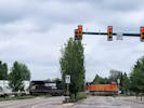 BNSF 5264 and NS 9580 lead a string of hoppers through downtown Fort Collins. BNSF 5264 and NS 9580 lead a string of hoppers through downtown Fort Collins.
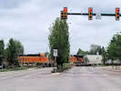 BNSF 7648 and BNSF 5540 bring up the rear on a string of hopper cars. BNSF 7648 and BNSF 5540 bring up the rear on a string of hopper cars.
|
Cross BNSF Railroad with US Highway 287.
|
|
Other articles:
• US Highway 287:
at CO 14 E;
Locations:
Fort Collins.
|
Fort Collins
Junction: US Highway 287, College Avenue, south.
|
|
Other articles:
• US Interstate 25:
36020;
|
Junction: US Interstate 25
|
|
|
Junction: Colorado State Highway 257
|
|
|
Junction: US Highway 85
|
|
|
Raymer
Junction: State Highway 52
|
|
|
Junction: State Highway 71, north.
|
|
|
Junction: State Highway 71, south.
|
|
|
Junction: South 4th Street, US Highway 6, one-way southwest.
|
|
Other articles:
• U. S. Highway 6:
at CO 14;
|
Junction: South 3rd Street, US Highway 6, one-way northeast.
|
|
If you have a question or a comment you may write to me at:
tomas@schweich.com
I sometimes post interesting questions in my FAQ, but I never disclose your full name or address.
|
[Home Page] [Site Map]
Date and time this article was prepared:
5/12/2025 2:49:22 PM
|
 Eastern Mojave Vegetation