Eastern Mojave Vegetation
Tom Schweich
|
Eastern Mojave Vegetation
| US Highway 287 |
|
Tom Schweich |

|
From Choteau, Montana, 100 miles (161 km) south of the Canadian border, at an intersection with U.S. Route 89, to Port Arthur, Texas at an intersection with State Highway 87, five miles (8 km) up the Sabine River from the Gulf of Mexico. | ||||||||||||||||||||||||||||||||||||||||||||||||||||||||||||||||||||||||||||||||||||||||||||||
|
|
ChoteauJunction: US Highway 89Northern End of Highway | ||||||||||||||||||||||||||||||||||||||||||||||||||||||||||||||||||||||||||||||||||||||||||||||
| Junction: US Interstate 90 | |||||||||||||||||||||||||||||||||||||||||||||||||||||||||||||||||||||||||||||||||||||||||||||||
|
Other articles:
|
Junction: West Entrance Road Yellowstone National Park below
|
Locations: Yellowstone National Park.
| Yellowstone National ParkIn Yellowstone National Park, US Highways are unnumbered. Therefore a gap exists in US Highway 287.
|
Other articles:
Yellowstone National Park above
| Junction: South Entrance Road
|
Other articles:
Locations:
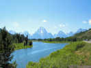
Oxbow Bend.
Oxbow Bend.
|
|
Other articles:
| Moran JunctionJunction: US Highways 26, 89, and 191. At Moran Junction, US Highways 89, 191, and 287 go north through Yellowstone National Park. US Highways 26, 89, and 191 go south through Jackson and along the Snake River. US Highways 26 and 287 go southeast through the Wind River Range. See US Highway 26 for commentary on that part of the shared route.
|
Other articles:
| US Highways 26 and 287 are concurrent from here northwest (above) to Moran Junction. Junction: US Highway 26
|
| Intersection: 4th Street
|
Locations: Lander.
| Lander
|
| Intersection: 3rd Street
|
Other articles:
| Intersecton: 1st Street
|
Other articles:
Junction: WY Highway 789, northeast to Riverton, or jointly southeast to US I-80 at Rawlins.
|
|
Other articles:
| Junction: Wyoming Highway 28 Wyoming Highway 28 (WYO 28) is a 96.5-mile (155.3 km) long Wyoming state highway known as the South Pass Highway. It travels from its split from Wyoming Highway 372 near the Seedskadee National Wildlife Refuge, across the high plains and over South Pass until its junction with U.S. Route 287 8 miles (13 km) south of Lander.
|
Other articles:
Junction: Wyoming 135, shortcut to Riverton.
|
|
| Sweetwater Station Rest Area
|
Locations: Sweetwater Station.
| Sweetwater Station
|
Locations: Sweetwater River.
| Cross Sweetwater River
|
Other articles:
| Jeffrey CityJeffrey City is the closest currrent location to Fremont's 1842 Cache Broad Camp on the Sweetwater River. It is here that he collected the type of Senecio spartioides on August 21, 1842.
|
Other articles:
Junction: Wyoming 220, to Caspar
|
|
| Great Divide Basin below
|
Great Divide Basin above
|
|
Other articles:
Junction: US Interstate 80, Rawlins exit (Exit 215), just east of Rawlins.
|
|
| US Highway 287 is concurrent with US Interstate 80 from Exit 215 near Rawlins to Exit 235 near Walcott.
|
Other articles:
Junction: US Interstate 80, at its Exit 235.
|
|
| Medicine BowJunction: Wyoming Highway 487, Utah Street, north to Caspar.
|
Other articles:
Junction: US Interstate 80, at its Exit 313 in Laramie. US Highway 287 having passed through Medicine Bow with US Highway 30, now crosses US Interstate 80 enroute to Fort Collins.
|
|
| Wyoming above Colorado below
|
Other articles:
Locations: Dale Creek.
| Cross Dale Creek
|
| Virginia Dale
|
Other articles:
Locations: Livermore.
| LivermoreJunction: W. County Road 74E, west to Red Feather Lakes.
Other articles:
Other articles:
Other articles:
Other articles:
Locations:
Fort Collins.
Other articles:
Locations:
Limon.
Other articles:
Other articles:
Other articles:
Other articles:
Other articles:
Other articles:
Other articles:
Locations:
Lamar.
Date and time this article was prepared:
4/21/2025 8:29:30 PM
|