Eastern Mojave Vegetation
Tom Schweich
|
Eastern Mojave Vegetation
| Field Notes (Continued) |
|
Tom Schweich |

Topics in this Article: 1800s 1900s 1910s 1920s 1930s 1940s 1950s 1960s 1970s 1980s 1990 1991 1992 1993 1995 1996 1997 1998 1999 2000 2001 2002 2003 2004 2005 2006 2007 2008 2008 Tour de Swertia albomarginata Mono Lake, August 2008 2009 2010 2011 2012 2013 2014 2015 2016 2017 2018 2019 2020 2021 2022 2023 2024 2025 Contents Literature Cited |
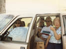
When I first read the field notes of Annie Alexander and Louise Kellogg, I was fascinated by the descriptions they wrote about the places they went and the plants and animals they found there. By publishing my field notes on the Internet I hope to follow a little bit in their tradition. | |||
|
|
1993 | |||
|
Other articles:
|
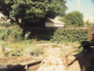
Trip to Carissa Plains | |||
|
|
Easter, April 11, 1993 | |||
|
|
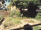
April 16, 1993 | |||
|
Other articles:
|
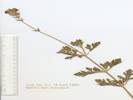
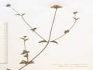
Amsinckia tessellata A. Gray var. tessellata. Bristly Fiddleneck.
Woods Mountains, San Bernardino County, California. in "Woods Wash," i.e., that portion of Black Canyon Wash on the south side of the Woods Mountains 35.0299°N, 115.3491°W. WGS1984. Coll. No. 2.1, 16 Apr 1993, characters observed while keying: Annual/perennial unknown, to 40 cm., stiff straight simple hairs; Stem erect; Leaves alternate, 60 mm. × 10 mm. wide, lanceolate, margin entire, tip obtuse; Inflorescence, coiled, crowded at distal stem, but not single; Pedicels 1 mm.; Calyx lobes 4, 6.5 mm., fused at base only, width varying from 0.7 to 1.2 mm., widest lobe notched; Corolla, 8? mm., tubular, tube color unknown; Ovary deeply lobed; Style base hidden within lobes; Nutlets, 2.2 mm., ±erect, scar lateral but otherwise unremarkable, prickles 0. | |||
|
Other articles:
|
2.3 |
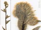
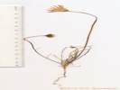
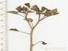
Ambrosia salsola (Torr. & A. Gray) Strother & B. G. Baldwin var. salsola. Cheese Bush.
Woods Mountains, San Bernardino County, California. in "Woods Wash," i.e., that portion of Black Canyon Wash on the south side of the Woods Mountains 35.0299°N, 115.3492°W. WGS 1984. (Insufficient material for voucher.) Coll. No. 2.3, 16 Apr 1993, characters observed while keying: Leaf blade linear to thread-like, Head, pistillate, phyllaries 2; Bur, palea tips membraneous wings, wings of bur 2.8 mm. wide. | ||
|
Other articles:
|
Encelia frutescens (A. Gray) A. Gray. Button Brittlebush.
Woods Mountains, San Bernardino County, California. in "Woods Wash," i.e., that portion of Black Canyon Wash on the south side of the Woods Mountains 35.0299°N, 115.3491°W. WGS1984 (Determination tentative.) Coll. No. 2.4, 16 April 1993, characters observed while keying: Perennial subshrub, to 30 cm.; Stem ascending; Leaf, petiole 2 mm. + blade 23 mm, ovate, margin wavy entire, short stiff hairy; Inflorescence in single heads, ray flowers absent or indistinguishable in this somewhat immature specimen; Phyllaries in 3 series, outer 6 mm. × 1.5 mm., 2nd series abruptly reduced in width; Receptacle paleate. | |||
|
Other articles:
|
3.1 |
Verbena gooddingii Briq. Southwestern Mock Vervain.
Woods Mountains, San Bernardino County, California. In "Woods Wash," i.e., that portion of Black Canyon Wash on the southwest side of the Woods Mountains, 2.3 miles east southeast of the intersection of Black Canyon Road and Wild Horse Canyon Road. 35.0265°N, 115.3498°W. WGS 1984. Coll. No. 3.1, 16 Apr 1993, characters observed while keying: Annual/perennial unknown, perennial assumed, subshrub, soft-hairy; Leaves, opposite, petiole 12 mm., blade 33 mm., lobed at base, toothed; Calyx, 8 mm., cylindric, 5-toothed, hairs spreading; Corolla, petals fused, radial, 12 mm., throat hairy, 5-lobed, limb 7 mm., blue; Ovary, 4-chambered. | ||
|
Other articles:
|
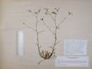
Malacothrix glabrata A. Gray. Desert Dandelion.
Woods Mountains, San Bernardino County, California. in "Woods Wash," i.e., that portion of Black Canyon Wash on the south side of the Woods Mountains 35.0299°N, 115.3491°W. WGS1984. Coll. No. 3.2, 16 Apr 1993, characters observed while keying: Annual herb, tap-rooted, to 20 cm.; Stem glabrous throughout, little branched; Inflorescence, only strap-shaped corollas; Phyllaries in 3 series, innermost much larger, 13 mm. × 3 mm. wide; Pappus on simple, long, smooth, persistent bristles; Ligule, 5-tipped; Corolla yellow/white; Fruit not compressed. | |||
|
Other articles:
|
Malacothrix californica DC. California Desert Dandelion.
Woods Mountains, San Bernardino County, California. in "Woods Wash," i.e., that portion of Black Canyon Wash on the south side of the Woods Mountains 35.0299°N, 115.3491°W. WGS1984 | |||
|
Other articles:
|
3.4 |
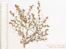
Phacelia fremontii Torr. Fremont's Phacelia.
Woods Mountains, San Bernardino County, California. in "Woods Wash," i.e., that portion of Black Canyon Wash on the south side of the Woods Mountains 35.0299°N, 115.3491°W. WGS1984. Coll. No. 3.4, keyed 3 Jan 2013, characters observed: Annual, 11 cm., from slender taproot; Stem hairy to glandular-hairy distally; Leaf 6 mm., blades deeply pinnately lobed; Inflorescence coiled; Bracts 5 mm., entire, tip rounded, glandular-hairy; Corollas funnelform, 12 mm. x 10 mm. dia, deciduous in fruit Ovary 2 mm., hairy; Style 4.5 mm, forked; Stamens included; Seeds few. Some dimensions and counts are small for P. fremontii; however, I this this is an early, small specimen. | ||
|
Other articles:
|
4.1 |
Gilia. sp.
Woods Mountains, San Bernardino County, California. In "Woods Wash," i.e., that portion of Black Canyon Wash on the south side of the Woods Mountains 35.0299°N, 115.3492°W. WGS1984 (Keys like a large G. minor, but fine details of corolla throat markings have faded.) Coll. No. 4.1, keyed 2 Jan 2013, characters observed: Annual to 32 cm.; Stem ascending, glandular in distal half; Leaves, rosette and cauline, deeply pinnately lobed; Basal and lower leaves, 50 mm., hairs non-glandular, cob-webby; Cauline leaves alternate, terminal lobe ±= lateral lobes; Inflorescence open cyme, not in heads; Pedicels varying, 1-12 mm.; Calyx 3 mm in flower, to 5 mm in fruit, lobes equal, glandular, membrane not spout-like distally; Corolla funnel-shaped, 8-9 mm., radial, lobes < tube, tube purple to mid-throat, no spots; Stigma, 0.7 mm., = stamens, forked; Stamens 5, equal; Filaments 6-7 mm., free distal 1 mm.; Seeds, many per chamber, light brown, gelatinous when wet. Keys to a large G. minor but fine details of corolla throat colors have faded. | ||
|
Other articles:
|
Encelia virginensis A. Nelson. Virgin River Brittlebush.
Woods Mountains, San Bernardino County, California. in "Woods Wash," i.e., that portion of Black Canyon Wash on the south side of the Woods Mountains 35.0299°N, 115.3492°W. WGS1984. Coll. No. 4.2, 16 Apr 1993, characters observed while keying: Perennial herb or subshrub, to 30 cm.; Hairs short white spreading, not glandular; Leaves, ?basal and cauline, generally alternate (can superficially appear opposite), abaxially strigose; Inflorescence, heads solitary, flowers of 2 kinds; Phyllaries in 2 series, outer 8 mm. × 1.8 mm. wide, inner slightly smaller, sometimes partially fused to ray flowers, without embedded oil glands; Receptacle paleate, enclosing disc ovaries; Pappus a low crown of scales on ray flowers and well-developed scales on disc flowers; Ray, yellow, blade elliptical, broad, 12 mm. ×6.5 mm., sterile; Fruit, compressed, margin thin, should be ciliate but unable to see in this specimen. | |||
|
Other articles:
|
4.3 |
Physalis crassifolia Benth. Thick Leaved Ground Cherry.
Woods Mountains, San Bernardino County, California. in "Woods Wash," i.e., that portion of Black Canyon Wash on the south side of the Woods Mountains 35.0299°N, 115.3492°W. WGS1984 Small fragment, without fruiting material. Coll. No. 4.3, 16 April 1993, characters observed while keying: Annual/perennial unknown, subshrub; Hairs, dense, short, unbranched, glandular; Stem ridged; Leaf, petiole 8-10 mm, blade 11 mm, ovate, margin wavy; Pedicel 7 mm; Calyx, in flower 4 mm, in fruit unknown; Corolla, 7 mm, yellow Fruit unknown. | ||
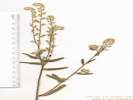 Coll. No. 7.2, Cryptantha muricata ? Coll. No. 7.2, Cryptantha muricata ?
|
Cryptantha muricata? Coll. No. 7.2, 16 Apr 1993, characters: Annual, taller than wide, Stem, loosely and sparsely branched, Nutlets, 4, 1.8 mm., color light greenish-brown, triangular-ovate, homomorphic, not rimmed or winged, ventral groove almost to nutlet apex, dorsal surfce with faint median ridge. Out of range for C. muricata. | |||
|
Other articles:
|
Baileya multiradiata Harv. & A. Gray ex Torr. Desert Marigold.
Woods Mountains, San Bernardino County, California. in "Woods Wash," i.e., that portion of Black Canyon Wash on the south side of the Woods Mountains 35.0299°N, 115.3492°W. WGS 1984. Coll. No. 7.4, 16 April 1993, characters observed while keying: Perennial, to 40 cm., gray- tomentose; Leaves alternate; Inflorescence solitary, 3.5-4.0 cm., head radiate, composed of 2 kinds of flowers; Phyllaries in 2 series, erect (not reflexed), unequal, outer longer, conspicuously overlapping, tomentose, margins not scarious; Receptacle epaleate; Rays, >15, corolla, 12 mm, yellow, 3-lobed; Fruit compressed. | |||
|
Other articles:
|
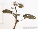
Phacelia campanularia A. Gray ssp. vasiformis G. Gillett. Desert Bluebells.
Woods Mountains, San Bernardino County, California. in "Woods Wash," i.e., that portion of Black Canyon Wash on the south side of the Woods Mountains 35.0298°N, 115.3492°W. WGS1984 Small collection in bad condition, discarded. Coll. No. 8.1, 16 Apr 1993, characters observed while keying: Annual/perennial unknown, height ≥ 25 cm.; Petiole 30 mm.; Leaf, blade round, 50 mm., veins palmate, shallowly lobed and toothed; Pedicels, in fruit, 10 mm., spreading(?, def. not reflexed); Calyx, in fruit, strap-shaped, 12 mm. × 1.5-2.0 mm wide; Corolla, 33 mm., blue, deciduous in fruit; Ovary, 6 mm. × 3.5 mm wide, ovate, short-hairy; Style, 30 mm., persistent, exserted, parted 8 of 30 mm., ±¼ of length; Seeds, ±20 per chamber, not all fully developed, 1 mm., pitted, winged one side(?). | |||
|
Other articles:
|
8.2 |
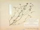
Acmispon rigidus (Benth.) Brouillet. Desert Rock Pea.
Woods Mountains, San Bernardino County, California. In "Woods Wash," i.e., that portion of Black Canyon Wash on the south side of the Woods Mountains, 2.8 miles east southeast of the Hole-in-the-Wall Information Center. 35.0263°N, 115.351°W. WGS 1984. Coll. No. 8.2, keyed 29 Nov 2012, characters observed: Perennial shrub or subshrub, to 40 cm., unarmed; Stem glabrous; Stipules gland-like; Leaves ternate, axis 3-4 mm.; Leaflets 3, not gland-dotted, few hairs, appressed, leaflet length 5x width; Inflorescence umbel, 1-3 flowered; Calyx conspicuous, strigose; Sepals fused > 1/2 length; Flower bilateral; Corolla conspicuous, 10 mm.; Stamens many fused, 1 free; Fruit indehiscent (expected to be dehiscent, perhaps insufficiently mature), flat. | ||
| 8.3 |
Dichelostemma capitatum (Benth.) Alph. Wood ssp. capitatum. Bluedicks. Collection destroyed; insufficient material for herbarium voucher. Collection No. 8.3, 15 August 2012, characters observed while keying: Geophyte, scapose, > 30 cm., Scape straight, Bracts 12 mm., purple, Pedicels 4 mm., Perianth 17 mm., parts fused at base, tube not narrowed above ovary, Stamens 6, 3 larger, 3 smaller, Filaments forming a crown-like tube outside anthers. | |||
|
Other articles:
|
Baileya multiradiata Harv. & A. Gray ex Torr. Desert Marigold.
Woods Mountains, San Bernardino County, California. in "Woods Wash," i.e., that portion of Black Canyon Wash on the south side of the Woods Mountains 35.0299°N, 115.3492°W. WGS 1984. | |||
|
Other articles:
|
| |||
|
Other articles:
Species Lists: Salvia dorrii |
14 |
| ||
|
Other articles:
|
||||
|
|
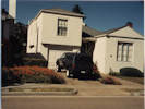
May 21-221993 Desert Research Symposium | |||
|
|
Saturday Afternoon, May 22ndField Trip | |||
|
Other articles:
Locations:
Thousand Palms Oasis.
|
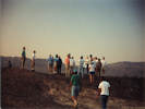
Stop 2. Thousand Palms Oasis | |||
|
Other articles:
Locations:
Willis Palms.
|
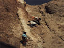
View of San Andreas Fault near Willis Palms. | |||
|
Other articles:
|
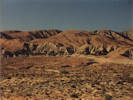
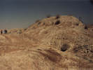
Top end of Box Canyon, view of sediments and playa. | |||
|
Other articles:
Locations:
Mecca Hills.
|
Sunday, May 23rd
| |||
|
Literature Cited:
Other articles:
|
| |||
|
Literature Cited:
Other articles:
|
| |||
|
Other articles:
Locations:
Fonts Point.
|
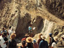
View from Fonts Point. | |||
| We ended this day at the Arroyo Salada Campground. | ||||
|
|
Monday, May 24th | |||
| Our route today took us from Arroyo Salada Campground through Borrego Springs, then Hemet, to San Timoteo Canyon. I bailed out there and drove as far as the Motel 6 at Twentynine Palms. | ||||
|
|
Tuesday, May 25thToday I drove from Twentynine Palms to Bonanza King Canyon. | |||
|
Other articles:
|
15 |
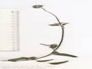
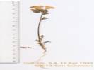
Dudleya saxosa (M. E. Jones) Britton & Rose ssp. aloides (Rose) Moran. Desert Dudleya.
Bonanza King Canyon, San Bernardino County, California. Mouth of the canyon. 34.9812°N, 115.5081°W. WGS1984 Elev. 1300 m. Occasional, in crevice of limestone outcrop. | ||
|
Other articles:
|
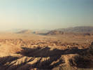
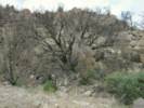
16 |
Quercus chrysolepis Liebm. Canyon Live Oak.
Wild Horse Mesa, San Bernardino County, California. North slope of Wild Horse Mesa. WGS1984 Elev. 1560 m. With Amelanchier utahensis, Garrya flavescens, Juniperus osteosperma, Pinus monophylla, and Rhamnus ilicifolia. Rare. | ||
|
Other articles:
|
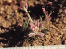
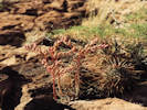
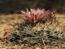
Escobaria vivipara beside the road to Lobo Point. | |||
|
Other articles:
|
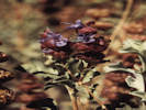
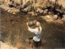
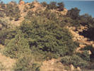
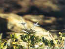
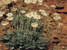
It is relatively rare to find Salvia mohavensis in bloom. May 1993, when this photograph was taken, is the only time I've seen the species in bloom at Lobo Point. In 1997, I would find it again at a rhyolite outcrop on the road north out of the valley of Lobo Point. | |||
| I think I stayed this night at Lobo Point. | ||||
|
|
Wednesday, May 26thToday I drove to the Las Vegas Airport from Lobo Point and picked up Cheryl. Then we headed north on US Highway 95. | |||
|
Other articles:
Locations:
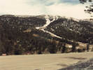
Lee Canyon.
|
| |||
| We ended this day at Beatty, Nevada. | ||||
|
|
Thursday, May 27th | |||
|
Other articles:
Locations:
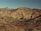
Titus Canyon.
|
| |||
|
Other articles:
Locations:
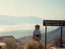
Aguereberry Point.
|
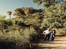
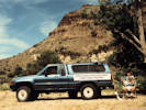
Lunch at Aguereberry Point. | |||
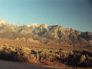
| Tried to get into the Onion Valley Campground, but it was full. So we settled on the Independence Creek Campground. | ||||
|
|
Friday, May 28th | |||
|
Other articles:
Locations:
Independence Creek Campground.
|
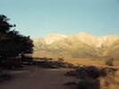
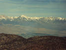
| |||
|
Other articles:
|
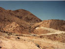
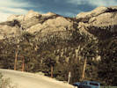
Viewpoint in the White Mountains. | |||
| I assume we drove home over Tioga Pass. | ||||
|
[Previous Page]
[Next Page]
Go to page: [1800s] [1900s] [1910s] [1920s] [1930s] [1940s] [1950s] [1960s] [1970s] [1980s] [1990] [1991] [1992] [1993] [1994] [1995] [1996] [1997] [1998] [1999] [2000] [2001] [2002] [2003] [2004] [2005] [2006] [2007] [2008] [2009] [2010] [2011] [2012] [2013] [2014] [2015] [2016] [2017] [2018] [2019] [2020] [2021] [2022] [2023] [2024] [2025] [A] | ||||
| If you have a question or a comment you may write to me at: tomas@schweich.com I sometimes post interesting questions in my FAQ, but I never disclose your full name or address. |
Date and time this article was prepared: 5/12/2025 2:50:39 PM |
|||