Eastern Mojave Vegetation
Tom Schweich
|
Eastern Mojave Vegetation
| Field Notes (Continued) |
|
Tom Schweich |

Topics in this Article: 1800s 1900s 1910s 1920s 1930s 1940s 1950s 1960s 1970s 1980s 1990 1991 1992 1993 1995 1996 1997 1998 1999 2000 2001 2002 2003 2004 2005 2006 2007 2008 2008 Tour de Swertia albomarginata Mono Lake, August 2008 2009 2010 2011 2012 2013 2014 2015 2016 2017 2018 2019 2020 2021 2022 2023 2024 2025 Contents Literature Cited |
When I first read the field notes of Annie Alexander and Louise Kellogg, I was fascinated by the descriptions they wrote about the places they went and the plants and animals they found there. By publishing my field notes on the Internet I hope to follow a little bit in their tradition. | |||||||||||||||||||||||||||||||||||||||||||||||||||||||||||||||||||||||||||||||||||||||||||||||||||||||||||||||||||||||||||||||||||||||||||||||||||||||||||||||||||||||||||||||||||||||||||||||||||||||||||||||||||||||||||||||||||||||||||||||||||||||||||||||||||||||||||||||||||||||||||||||||||||||||||||||||||||||||||||||||||||||||||||||||||||||||||||||||||||||||||||||||||||||||||||||||||||||||||||||||||||||||||||||||||||||||||||||||||||||||||||||||||||||||||||||||||||||||||||||||||||||||||||||||||||||||||||||||||||||||||||||||||||||||||||||||||||||||||||||||||||||||||||||||||||||||||||||||||||||||||||||||||||||||||||||||||||||||||||||||||||||||||||
|
|
2004 | |||||||||||||||||||||||||||||||||||||||||||||||||||||||||||||||||||||||||||||||||||||||||||||||||||||||||||||||||||||||||||||||||||||||||||||||||||||||||||||||||||||||||||||||||||||||||||||||||||||||||||||||||||||||||||||||||||||||||||||||||||||||||||||||||||||||||||||||||||||||||||||||||||||||||||||||||||||||||||||||||||||||||||||||||||||||||||||||||||||||||||||||||||||||||||||||||||||||||||||||||||||||||||||||||||||||||||||||||||||||||||||||||||||||||||||||||||||||||||||||||||||||||||||||||||||||||||||||||||||||||||||||||||||||||||||||||||||||||||||||||||||||||||||||||||||||||||||||||||||||||||||||||||||||||||||||||||||||||||||||||||||||||||||
My 2004 Trip To Spain | ||||||||||||||||||||||||||||||||||||||||||||||||||||||||||||||||||||||||||||||||||||||||||||||||||||||||||||||||||||||||||||||||||||||||||||||||||||||||||||||||||||||||||||||||||||||||||||||||||||||||||||||||||||||||||||||||||||||||||||||||||||||||||||||||||||||||||||||||||||||||||||||||||||||||||||||||||||||||||||||||||||||||||||||||||||||||||||||||||||||||||||||||||||||||||||||||||||||||||||||||||||||||||||||||||||||||||||||||||||||||||||||||||||||||||||||||||||||||||||||||||||||||||||||||||||||||||||||||||||||||||||||||||||||||||||||||||||||||||||||||||||||||||||||||||||||||||||||||||||||||||||||||||||||||||||||||||||||||||||||||||||||||||||||
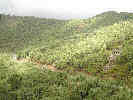
| From Thursday, February 12 to Tuesday February 23, 2004, we traveled to Spain, where I collected a few weeds and made a short trip to the Sierra Bermeja to see the Pinsapo (Pinus pinsapo Boiss.). | ||||||||||||||||||||||||||||||||||||||||||||||||||||||||||||||||||||||||||||||||||||||||||||||||||||||||||||||||||||||||||||||||||||||||||||||||||||||||||||||||||||||||||||||||||||||||||||||||||||||||||||||||||||||||||||||||||||||||||||||||||||||||||||||||||||||||||||||||||||||||||||||||||||||||||||||||||||||||||||||||||||||||||||||||||||||||||||||||||||||||||||||||||||||||||||||||||||||||||||||||||||||||||||||||||||||||||||||||||||||||||||||||||||||||||||||||||||||||||||||||||||||||||||||||||||||||||||||||||||||||||||||||||||||||||||||||||||||||||||||||||||||||||||||||||||||||||||||||||||||||||||||||||||||||||||||||||||||||||||||||||||||||||||||
|
|
Thursday February 12th | |||||||||||||||||||||||||||||||||||||||||||||||||||||||||||||||||||||||||||||||||||||||||||||||||||||||||||||||||||||||||||||||||||||||||||||||||||||||||||||||||||||||||||||||||||||||||||||||||||||||||||||||||||||||||||||||||||||||||||||||||||||||||||||||||||||||||||||||||||||||||||||||||||||||||||||||||||||||||||||||||||||||||||||||||||||||||||||||||||||||||||||||||||||||||||||||||||||||||||||||||||||||||||||||||||||||||||||||||||||||||||||||||||||||||||||||||||||||||||||||||||||||||||||||||||||||||||||||||||||||||||||||||||||||||||||||||||||||||||||||||||||||||||||||||||||||||||||||||||||||||||||||||||||||||||||||||||||||||||||||||||||||||||||
| Our flight took off from San Francisco a few minutes late due to the large crowd on the plane. Not much to say about the flight, except that we arrived in Philadelphia a few minutes early. | ||||||||||||||||||||||||||||||||||||||||||||||||||||||||||||||||||||||||||||||||||||||||||||||||||||||||||||||||||||||||||||||||||||||||||||||||||||||||||||||||||||||||||||||||||||||||||||||||||||||||||||||||||||||||||||||||||||||||||||||||||||||||||||||||||||||||||||||||||||||||||||||||||||||||||||||||||||||||||||||||||||||||||||||||||||||||||||||||||||||||||||||||||||||||||||||||||||||||||||||||||||||||||||||||||||||||||||||||||||||||||||||||||||||||||||||||||||||||||||||||||||||||||||||||||||||||||||||||||||||||||||||||||||||||||||||||||||||||||||||||||||||||||||||||||||||||||||||||||||||||||||||||||||||||||||||||||||||||||||||||||||||||||||||
|
Locations: Sevilla. |
We walked over to the international terminal to wait for our flight to Madrid. The plane was a few minutes late arriving from Cancun, so we left a few minutes late for Madrid. The plane to Madrid is also full. | |||||||||||||||||||||||||||||||||||||||||||||||||||||||||||||||||||||||||||||||||||||||||||||||||||||||||||||||||||||||||||||||||||||||||||||||||||||||||||||||||||||||||||||||||||||||||||||||||||||||||||||||||||||||||||||||||||||||||||||||||||||||||||||||||||||||||||||||||||||||||||||||||||||||||||||||||||||||||||||||||||||||||||||||||||||||||||||||||||||||||||||||||||||||||||||||||||||||||||||||||||||||||||||||||||||||||||||||||||||||||||||||||||||||||||||||||||||||||||||||||||||||||||||||||||||||||||||||||||||||||||||||||||||||||||||||||||||||||||||||||||||||||||||||||||||||||||||||||||||||||||||||||||||||||||||||||||||||||||||||||||||||||||||
| There was one poor young man who had lost his passport at Philadelphia. No one could find it, but they made repeated announcements of a lost passport in the airport. Someone must have found it because he was last on the plane, with his passport, to a rousing cheer from the group with whom he was traveling. | ||||||||||||||||||||||||||||||||||||||||||||||||||||||||||||||||||||||||||||||||||||||||||||||||||||||||||||||||||||||||||||||||||||||||||||||||||||||||||||||||||||||||||||||||||||||||||||||||||||||||||||||||||||||||||||||||||||||||||||||||||||||||||||||||||||||||||||||||||||||||||||||||||||||||||||||||||||||||||||||||||||||||||||||||||||||||||||||||||||||||||||||||||||||||||||||||||||||||||||||||||||||||||||||||||||||||||||||||||||||||||||||||||||||||||||||||||||||||||||||||||||||||||||||||||||||||||||||||||||||||||||||||||||||||||||||||||||||||||||||||||||||||||||||||||||||||||||||||||||||||||||||||||||||||||||||||||||||||||||||||||||||||||||||
|
|
Friday February 13th | |||||||||||||||||||||||||||||||||||||||||||||||||||||||||||||||||||||||||||||||||||||||||||||||||||||||||||||||||||||||||||||||||||||||||||||||||||||||||||||||||||||||||||||||||||||||||||||||||||||||||||||||||||||||||||||||||||||||||||||||||||||||||||||||||||||||||||||||||||||||||||||||||||||||||||||||||||||||||||||||||||||||||||||||||||||||||||||||||||||||||||||||||||||||||||||||||||||||||||||||||||||||||||||||||||||||||||||||||||||||||||||||||||||||||||||||||||||||||||||||||||||||||||||||||||||||||||||||||||||||||||||||||||||||||||||||||||||||||||||||||||||||||||||||||||||||||||||||||||||||||||||||||||||||||||||||||||||||||||||||||||||||||||||
| Our flight arrived at about 945 AM, about 15 minutes late. It took a few minutes to get off the plane. The lines at Passport Control were pretty long, and it took 15-20 minutes to get our passports stamped. No hurry, though, as it was another 10-15 minutes before our luggage arrived. At the airport, we took a taxi to the Atocha railroad station, arriving about 10 minutes after 1100 AM. It was a good thing we had reservations on the Noon AVE, as we would not have made the 1100 AM train. | ||||||||||||||||||||||||||||||||||||||||||||||||||||||||||||||||||||||||||||||||||||||||||||||||||||||||||||||||||||||||||||||||||||||||||||||||||||||||||||||||||||||||||||||||||||||||||||||||||||||||||||||||||||||||||||||||||||||||||||||||||||||||||||||||||||||||||||||||||||||||||||||||||||||||||||||||||||||||||||||||||||||||||||||||||||||||||||||||||||||||||||||||||||||||||||||||||||||||||||||||||||||||||||||||||||||||||||||||||||||||||||||||||||||||||||||||||||||||||||||||||||||||||||||||||||||||||||||||||||||||||||||||||||||||||||||||||||||||||||||||||||||||||||||||||||||||||||||||||||||||||||||||||||||||||||||||||||||||||||||||||||||||||||||
| The platform for our train to Seville was not announced yet, so we waited a few minutes until 1130 AM when our train was announced. | ||||||||||||||||||||||||||||||||||||||||||||||||||||||||||||||||||||||||||||||||||||||||||||||||||||||||||||||||||||||||||||||||||||||||||||||||||||||||||||||||||||||||||||||||||||||||||||||||||||||||||||||||||||||||||||||||||||||||||||||||||||||||||||||||||||||||||||||||||||||||||||||||||||||||||||||||||||||||||||||||||||||||||||||||||||||||||||||||||||||||||||||||||||||||||||||||||||||||||||||||||||||||||||||||||||||||||||||||||||||||||||||||||||||||||||||||||||||||||||||||||||||||||||||||||||||||||||||||||||||||||||||||||||||||||||||||||||||||||||||||||||||||||||||||||||||||||||||||||||||||||||||||||||||||||||||||||||||||||||||||||||||||||||||
| The train attendants saw us coming with our baggage and asked to check our luggage. We agreed, and found it easier than loading the baggage on our car ourselves. Our seats were in the left side of the train, two seats facing each other. I was able to stay awake only about the first half hour, then Cheryl and I traded seats so she could sit facing forward and see the scenery, while I rode backward with my head slumped over, sleeping. I vaguely remember stopping in Cordoba, and then we were in Sevilla. | ||||||||||||||||||||||||||||||||||||||||||||||||||||||||||||||||||||||||||||||||||||||||||||||||||||||||||||||||||||||||||||||||||||||||||||||||||||||||||||||||||||||||||||||||||||||||||||||||||||||||||||||||||||||||||||||||||||||||||||||||||||||||||||||||||||||||||||||||||||||||||||||||||||||||||||||||||||||||||||||||||||||||||||||||||||||||||||||||||||||||||||||||||||||||||||||||||||||||||||||||||||||||||||||||||||||||||||||||||||||||||||||||||||||||||||||||||||||||||||||||||||||||||||||||||||||||||||||||||||||||||||||||||||||||||||||||||||||||||||||||||||||||||||||||||||||||||||||||||||||||||||||||||||||||||||||||||||||||||||||||||||||||||||||
| Rachel met us at the train station. She came on the bus from her school. We had juice while we waited for Nacho. When Nacho arrived, Rachel drove us home in the car, while Nacho stayed in Sevilla to teach his class. | ||||||||||||||||||||||||||||||||||||||||||||||||||||||||||||||||||||||||||||||||||||||||||||||||||||||||||||||||||||||||||||||||||||||||||||||||||||||||||||||||||||||||||||||||||||||||||||||||||||||||||||||||||||||||||||||||||||||||||||||||||||||||||||||||||||||||||||||||||||||||||||||||||||||||||||||||||||||||||||||||||||||||||||||||||||||||||||||||||||||||||||||||||||||||||||||||||||||||||||||||||||||||||||||||||||||||||||||||||||||||||||||||||||||||||||||||||||||||||||||||||||||||||||||||||||||||||||||||||||||||||||||||||||||||||||||||||||||||||||||||||||||||||||||||||||||||||||||||||||||||||||||||||||||||||||||||||||||||||||||||||||||||||||||
|
Locations:
Bormujos.
|
At home in Bormujos we met Kiko the cat, and visited a bit. Cheryl and Rachel started going through all the things that Cheryl had brought in her second suitcase: lots of baby clothes, diapers, etc. As I was starting to fade fast just sitting on the couch, I decided to take a walk. I walked all around the development containing Rachel and Nacho's house, over to the hospital, down to the University, up to the MAS supermarket, and then home again. This took about a half hour, and helped wake me up a bit. | |||||||||||||||||||||||||||||||||||||||||||||||||||||||||||||||||||||||||||||||||||||||||||||||||||||||||||||||||||||||||||||||||||||||||||||||||||||||||||||||||||||||||||||||||||||||||||||||||||||||||||||||||||||||||||||||||||||||||||||||||||||||||||||||||||||||||||||||||||||||||||||||||||||||||||||||||||||||||||||||||||||||||||||||||||||||||||||||||||||||||||||||||||||||||||||||||||||||||||||||||||||||||||||||||||||||||||||||||||||||||||||||||||||||||||||||||||||||||||||||||||||||||||||||||||||||||||||||||||||||||||||||||||||||||||||||||||||||||||||||||||||||||||||||||||||||||||||||||||||||||||||||||||||||||||||||||||||||||||||||||||||||||||||
| In the evening after Rachel went to get Nacho, we decided to get Chinese food, so Rachel, Nacho and I walked over to the Chinese restaurant, and ordered some food. The House Special Soup was a bit of a combination Egg Drop and Hot and Sour soup, there was Chow Mein, Sweet and Sour Chicken and vegetables. No fortune cookies. There were also some traditional Spanish foods on the menu. The food was good, but not seasoned as much as we would expect from Chinese food. | ||||||||||||||||||||||||||||||||||||||||||||||||||||||||||||||||||||||||||||||||||||||||||||||||||||||||||||||||||||||||||||||||||||||||||||||||||||||||||||||||||||||||||||||||||||||||||||||||||||||||||||||||||||||||||||||||||||||||||||||||||||||||||||||||||||||||||||||||||||||||||||||||||||||||||||||||||||||||||||||||||||||||||||||||||||||||||||||||||||||||||||||||||||||||||||||||||||||||||||||||||||||||||||||||||||||||||||||||||||||||||||||||||||||||||||||||||||||||||||||||||||||||||||||||||||||||||||||||||||||||||||||||||||||||||||||||||||||||||||||||||||||||||||||||||||||||||||||||||||||||||||||||||||||||||||||||||||||||||||||||||||||||||||||
|
|
Saturday February 14th. | |||||||||||||||||||||||||||||||||||||||||||||||||||||||||||||||||||||||||||||||||||||||||||||||||||||||||||||||||||||||||||||||||||||||||||||||||||||||||||||||||||||||||||||||||||||||||||||||||||||||||||||||||||||||||||||||||||||||||||||||||||||||||||||||||||||||||||||||||||||||||||||||||||||||||||||||||||||||||||||||||||||||||||||||||||||||||||||||||||||||||||||||||||||||||||||||||||||||||||||||||||||||||||||||||||||||||||||||||||||||||||||||||||||||||||||||||||||||||||||||||||||||||||||||||||||||||||||||||||||||||||||||||||||||||||||||||||||||||||||||||||||||||||||||||||||||||||||||||||||||||||||||||||||||||||||||||||||||||||||||||||||||||||||
|
Other articles:
|
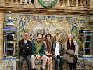
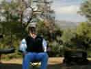
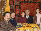
This morning we got up about 930 AM. After breakfast we drove into the "Center" (downtown Seville) and met Nacho's parents, Julio and Maria Jesus. We walked through Parque Maria Luisa and then part of the Plaza de España. At the Plaza de Espana, there are tile displays for each of the provinces of Spain. We stopped and took this photo at the tile display for Pontevedra. Nachos mother is from Pontevedra. The tiles depict a scene from the history of the city. Unfortunately, I did not write down the event in history. | |||||||||||||||||||||||||||||||||||||||||||||||||||||||||||||||||||||||||||||||||||||||||||||||||||||||||||||||||||||||||||||||||||||||||||||||||||||||||||||||||||||||||||||||||||||||||||||||||||||||||||||||||||||||||||||||||||||||||||||||||||||||||||||||||||||||||||||||||||||||||||||||||||||||||||||||||||||||||||||||||||||||||||||||||||||||||||||||||||||||||||||||||||||||||||||||||||||||||||||||||||||||||||||||||||||||||||||||||||||||||||||||||||||||||||||||||||||||||||||||||||||||||||||||||||||||||||||||||||||||||||||||||||||||||||||||||||||||||||||||||||||||||||||||||||||||||||||||||||||||||||||||||||||||||||||||||||||||||||||||||||||||||||||
| At a terrace restaurant at the edge of the park, we had a coffee. From there we walked through the Barrio Santa Cruz to Plaza Alfalfa, where we met Pamen and Julio and their two children: Marta and Julio (sometimes called "Julito" or little Julio). | ||||||||||||||||||||||||||||||||||||||||||||||||||||||||||||||||||||||||||||||||||||||||||||||||||||||||||||||||||||||||||||||||||||||||||||||||||||||||||||||||||||||||||||||||||||||||||||||||||||||||||||||||||||||||||||||||||||||||||||||||||||||||||||||||||||||||||||||||||||||||||||||||||||||||||||||||||||||||||||||||||||||||||||||||||||||||||||||||||||||||||||||||||||||||||||||||||||||||||||||||||||||||||||||||||||||||||||||||||||||||||||||||||||||||||||||||||||||||||||||||||||||||||||||||||||||||||||||||||||||||||||||||||||||||||||||||||||||||||||||||||||||||||||||||||||||||||||||||||||||||||||||||||||||||||||||||||||||||||||||||||||||||||||||
 Lunch at Habanita Lunch at Habanita
|
We had lunch at Habanita, a Cuban restaurant in Alfalfa. We had various things to start, including Bleu Cheese croquettes and Spinach croquettes. I had the lamb meat balls on cous-cous. It was pretty good, but I was a bit surprised by cumin seasoning instead of garlic. Maria Jesus had a combination plate, from which I tried the fried Yucca. Not much flavor, and a bit fibrous, but not bad. Unfortunately, they did not have salmorejo today, which was a bit of a disappointment. | |||||||||||||||||||||||||||||||||||||||||||||||||||||||||||||||||||||||||||||||||||||||||||||||||||||||||||||||||||||||||||||||||||||||||||||||||||||||||||||||||||||||||||||||||||||||||||||||||||||||||||||||||||||||||||||||||||||||||||||||||||||||||||||||||||||||||||||||||||||||||||||||||||||||||||||||||||||||||||||||||||||||||||||||||||||||||||||||||||||||||||||||||||||||||||||||||||||||||||||||||||||||||||||||||||||||||||||||||||||||||||||||||||||||||||||||||||||||||||||||||||||||||||||||||||||||||||||||||||||||||||||||||||||||||||||||||||||||||||||||||||||||||||||||||||||||||||||||||||||||||||||||||||||||||||||||||||||||||||||||||||||||||||||
 Lunch at Habanita Lunch at Habanita
|
When the waitress first came to our table, Pamen asked for some food for the children. Some meat and french fries were brought out to the table very quickly. The children then got to eat quickly, while the adults had drinks, then appetizers, and finally their meal. | |||||||||||||||||||||||||||||||||||||||||||||||||||||||||||||||||||||||||||||||||||||||||||||||||||||||||||||||||||||||||||||||||||||||||||||||||||||||||||||||||||||||||||||||||||||||||||||||||||||||||||||||||||||||||||||||||||||||||||||||||||||||||||||||||||||||||||||||||||||||||||||||||||||||||||||||||||||||||||||||||||||||||||||||||||||||||||||||||||||||||||||||||||||||||||||||||||||||||||||||||||||||||||||||||||||||||||||||||||||||||||||||||||||||||||||||||||||||||||||||||||||||||||||||||||||||||||||||||||||||||||||||||||||||||||||||||||||||||||||||||||||||||||||||||||||||||||||||||||||||||||||||||||||||||||||||||||||||||||||||||||||||||||||
| I noticed another party in the restaurant did the same thing. After eating, it was OK for the children to get up and visit their grandparents, and other adults around the table. I thought that was a good approach, as I think in the US, we expect the kids to wait patiently until the adult meal was served before the kids could eat. At large family meals, it is often the same; first, the kids are fed, then the adults eat while the kids play. | ||||||||||||||||||||||||||||||||||||||||||||||||||||||||||||||||||||||||||||||||||||||||||||||||||||||||||||||||||||||||||||||||||||||||||||||||||||||||||||||||||||||||||||||||||||||||||||||||||||||||||||||||||||||||||||||||||||||||||||||||||||||||||||||||||||||||||||||||||||||||||||||||||||||||||||||||||||||||||||||||||||||||||||||||||||||||||||||||||||||||||||||||||||||||||||||||||||||||||||||||||||||||||||||||||||||||||||||||||||||||||||||||||||||||||||||||||||||||||||||||||||||||||||||||||||||||||||||||||||||||||||||||||||||||||||||||||||||||||||||||||||||||||||||||||||||||||||||||||||||||||||||||||||||||||||||||||||||||||||||||||||||||||||||
| On the walk back to the car, we stopped for a few minutes at a new store called OpenCor, which had a little bit of everything. A little more stuff than a 7-11, maybe more variety, and no gas, but otherwise similar on the concept. Nacho's parents and Julio and Pamen came up to Rachel and Nacho's house. This was the first time that Julio and Maria Jesus had seen the house. | ||||||||||||||||||||||||||||||||||||||||||||||||||||||||||||||||||||||||||||||||||||||||||||||||||||||||||||||||||||||||||||||||||||||||||||||||||||||||||||||||||||||||||||||||||||||||||||||||||||||||||||||||||||||||||||||||||||||||||||||||||||||||||||||||||||||||||||||||||||||||||||||||||||||||||||||||||||||||||||||||||||||||||||||||||||||||||||||||||||||||||||||||||||||||||||||||||||||||||||||||||||||||||||||||||||||||||||||||||||||||||||||||||||||||||||||||||||||||||||||||||||||||||||||||||||||||||||||||||||||||||||||||||||||||||||||||||||||||||||||||||||||||||||||||||||||||||||||||||||||||||||||||||||||||||||||||||||||||||||||||||||||||||||||
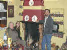
| Kiko the cat was an instant hit with Marta and "Julito" and they played with and chased Kiko the entire time, both inside and out. The adults visited and talked, in both English and Spanish. Nacho's brother, Julio, speaks very good English, and Pamen speaks more than I thought. Some time ago Pamen gave Rachel and Nacho a painting of oranges, orange blossoms in an orange tree that she had painted from the family's country house in San Javier. Rachel and Nacho have hung the painting above their fireplace on a living room wall, which is also the exact color as the oranges. | ||||||||||||||||||||||||||||||||||||||||||||||||||||||||||||||||||||||||||||||||||||||||||||||||||||||||||||||||||||||||||||||||||||||||||||||||||||||||||||||||||||||||||||||||||||||||||||||||||||||||||||||||||||||||||||||||||||||||||||||||||||||||||||||||||||||||||||||||||||||||||||||||||||||||||||||||||||||||||||||||||||||||||||||||||||||||||||||||||||||||||||||||||||||||||||||||||||||||||||||||||||||||||||||||||||||||||||||||||||||||||||||||||||||||||||||||||||||||||||||||||||||||||||||||||||||||||||||||||||||||||||||||||||||||||||||||||||||||||||||||||||||||||||||||||||||||||||||||||||||||||||||||||||||||||||||||||||||||||||||||||||||||||||||
| After visiting Julio and Maria Jesus went back to the military residence in Sevilla where they are staying, and Pamen, Julio, Marta and Julito drove home to the Navy base at Rota. | ||||||||||||||||||||||||||||||||||||||||||||||||||||||||||||||||||||||||||||||||||||||||||||||||||||||||||||||||||||||||||||||||||||||||||||||||||||||||||||||||||||||||||||||||||||||||||||||||||||||||||||||||||||||||||||||||||||||||||||||||||||||||||||||||||||||||||||||||||||||||||||||||||||||||||||||||||||||||||||||||||||||||||||||||||||||||||||||||||||||||||||||||||||||||||||||||||||||||||||||||||||||||||||||||||||||||||||||||||||||||||||||||||||||||||||||||||||||||||||||||||||||||||||||||||||||||||||||||||||||||||||||||||||||||||||||||||||||||||||||||||||||||||||||||||||||||||||||||||||||||||||||||||||||||||||||||||||||||||||||||||||||||||||||
| We went to the supermarket near the other end of Bormujos, as there was not much food in the house. Parking for the supermarket is in the basement and you ride an elevator that lets you off at the checkout counters. For ground turkey, you pick out some turkey you like and the butcher grinds it on the spot. Most of the fruits and vegetables are prepackaged and pre-priced. Otherwise, it wasn't much different that what we have. | ||||||||||||||||||||||||||||||||||||||||||||||||||||||||||||||||||||||||||||||||||||||||||||||||||||||||||||||||||||||||||||||||||||||||||||||||||||||||||||||||||||||||||||||||||||||||||||||||||||||||||||||||||||||||||||||||||||||||||||||||||||||||||||||||||||||||||||||||||||||||||||||||||||||||||||||||||||||||||||||||||||||||||||||||||||||||||||||||||||||||||||||||||||||||||||||||||||||||||||||||||||||||||||||||||||||||||||||||||||||||||||||||||||||||||||||||||||||||||||||||||||||||||||||||||||||||||||||||||||||||||||||||||||||||||||||||||||||||||||||||||||||||||||||||||||||||||||||||||||||||||||||||||||||||||||||||||||||||||||||||||||||||||||||
| For dinner, we were pretty informal, Rachel had leftover Chinese food, I had some left over Chinese soup, an apple and some cheese. I think Cheryl had an orange, and Nacho had some of the soup and a sandwich. | ||||||||||||||||||||||||||||||||||||||||||||||||||||||||||||||||||||||||||||||||||||||||||||||||||||||||||||||||||||||||||||||||||||||||||||||||||||||||||||||||||||||||||||||||||||||||||||||||||||||||||||||||||||||||||||||||||||||||||||||||||||||||||||||||||||||||||||||||||||||||||||||||||||||||||||||||||||||||||||||||||||||||||||||||||||||||||||||||||||||||||||||||||||||||||||||||||||||||||||||||||||||||||||||||||||||||||||||||||||||||||||||||||||||||||||||||||||||||||||||||||||||||||||||||||||||||||||||||||||||||||||||||||||||||||||||||||||||||||||||||||||||||||||||||||||||||||||||||||||||||||||||||||||||||||||||||||||||||||||||||||||||||||||||
| Tomorrow (Sunday) I think Julio and Maria Jesus are coming over for a while. Otherwise, I don't think there is much on the agenda. | ||||||||||||||||||||||||||||||||||||||||||||||||||||||||||||||||||||||||||||||||||||||||||||||||||||||||||||||||||||||||||||||||||||||||||||||||||||||||||||||||||||||||||||||||||||||||||||||||||||||||||||||||||||||||||||||||||||||||||||||||||||||||||||||||||||||||||||||||||||||||||||||||||||||||||||||||||||||||||||||||||||||||||||||||||||||||||||||||||||||||||||||||||||||||||||||||||||||||||||||||||||||||||||||||||||||||||||||||||||||||||||||||||||||||||||||||||||||||||||||||||||||||||||||||||||||||||||||||||||||||||||||||||||||||||||||||||||||||||||||||||||||||||||||||||||||||||||||||||||||||||||||||||||||||||||||||||||||||||||||||||||||||||||||
|
|
Sunday February 15 | |||||||||||||||||||||||||||||||||||||||||||||||||||||||||||||||||||||||||||||||||||||||||||||||||||||||||||||||||||||||||||||||||||||||||||||||||||||||||||||||||||||||||||||||||||||||||||||||||||||||||||||||||||||||||||||||||||||||||||||||||||||||||||||||||||||||||||||||||||||||||||||||||||||||||||||||||||||||||||||||||||||||||||||||||||||||||||||||||||||||||||||||||||||||||||||||||||||||||||||||||||||||||||||||||||||||||||||||||||||||||||||||||||||||||||||||||||||||||||||||||||||||||||||||||||||||||||||||||||||||||||||||||||||||||||||||||||||||||||||||||||||||||||||||||||||||||||||||||||||||||||||||||||||||||||||||||||||||||||||||||||||||||||||
| This morning we drove into Sevilla to see Nika and Carlos and their new baby Miguel. They are buying a house in Tarifa, to be closer to Carlos business of making and selling surfboards and related equipment, and will probably move there this summer. | ||||||||||||||||||||||||||||||||||||||||||||||||||||||||||||||||||||||||||||||||||||||||||||||||||||||||||||||||||||||||||||||||||||||||||||||||||||||||||||||||||||||||||||||||||||||||||||||||||||||||||||||||||||||||||||||||||||||||||||||||||||||||||||||||||||||||||||||||||||||||||||||||||||||||||||||||||||||||||||||||||||||||||||||||||||||||||||||||||||||||||||||||||||||||||||||||||||||||||||||||||||||||||||||||||||||||||||||||||||||||||||||||||||||||||||||||||||||||||||||||||||||||||||||||||||||||||||||||||||||||||||||||||||||||||||||||||||||||||||||||||||||||||||||||||||||||||||||||||||||||||||||||||||||||||||||||||||||||||||||||||||||||||||||
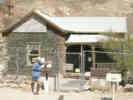
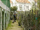
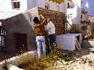 Nacho and Tom work on the fence. Nacho and Tom work on the fence.
|
Back at the house Nacho and I worked to remove some of the chain link fence at the back of the yard. The neighbors behind Nacho and Rachel are having a garden shed constructed that backs up to the fence. Since most construction is done in brick with cement plaster coating, the back side facing the yard was rough brick and mortar. We needed to remove the chain link fencing so that the workmen can finish the side facing the yard. | |||||||||||||||||||||||||||||||||||||||||||||||||||||||||||||||||||||||||||||||||||||||||||||||||||||||||||||||||||||||||||||||||||||||||||||||||||||||||||||||||||||||||||||||||||||||||||||||||||||||||||||||||||||||||||||||||||||||||||||||||||||||||||||||||||||||||||||||||||||||||||||||||||||||||||||||||||||||||||||||||||||||||||||||||||||||||||||||||||||||||||||||||||||||||||||||||||||||||||||||||||||||||||||||||||||||||||||||||||||||||||||||||||||||||||||||||||||||||||||||||||||||||||||||||||||||||||||||||||||||||||||||||||||||||||||||||||||||||||||||||||||||||||||||||||||||||||||||||||||||||||||||||||||||||||||||||||||||||||||||||||||||||||||
| Then, Rachel and Cheryl talked while Nacho took a nap, and I went out collecting weeds in the neighborhood. One thing I collected was definitely a Solanum, another in the Hydrophyllaceae, probably a Phacelia, one that looks like the Evening Primrose Family (Onagraceae) and a couple more, one that looked like an Astragalus from a distance, but definitely wasn't one close up. I don't have a plant press so I put the plants between sheets of newspaper, then put some bricks on top of them and then added a sack half-full with cement to press the plants. We'll see how it works. | ||||||||||||||||||||||||||||||||||||||||||||||||||||||||||||||||||||||||||||||||||||||||||||||||||||||||||||||||||||||||||||||||||||||||||||||||||||||||||||||||||||||||||||||||||||||||||||||||||||||||||||||||||||||||||||||||||||||||||||||||||||||||||||||||||||||||||||||||||||||||||||||||||||||||||||||||||||||||||||||||||||||||||||||||||||||||||||||||||||||||||||||||||||||||||||||||||||||||||||||||||||||||||||||||||||||||||||||||||||||||||||||||||||||||||||||||||||||||||||||||||||||||||||||||||||||||||||||||||||||||||||||||||||||||||||||||||||||||||||||||||||||||||||||||||||||||||||||||||||||||||||||||||||||||||||||||||||||||||||||||||||||||||||||
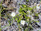
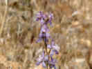
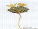
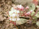
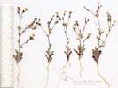
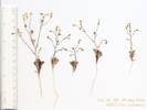
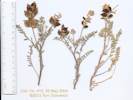
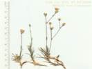
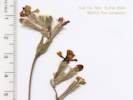 Coll. No. 324, Silene scabriflora Coll. No. 324, Silene scabriflora
 Coll. No. 324, Silene scabriflora Coll. No. 324, Silene scabriflora
|
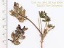
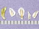
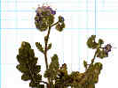
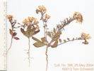
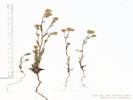
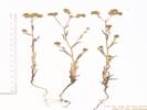
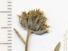
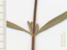
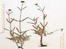
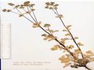
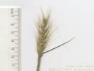
324 |
Silene scabriflora Brot.
Bormujos, (Sevilla) Andalucia. In the neglected olive grove just west of the Hospital San Juan de Dios del Aljarafe, now the location of the elementary school: CEIP Santo Domingo de Silos. 37.3723°N, 6.0858°W. WGS1984 Elev. 96 m. Coll. No. 324, keyed 13 Dec 2012, characters observed: Herbaceous perennial (?), to 40 cm.; Leaves opposite, oblanceolate, to 30 mm. x 10 mm., smaller distally; Inflorescence raceme; Calyx 11 mm x 4 mm. wide, dark ribbed; Sepals fused most of length (90% ?), strong dark mid-rib, long wavy hairs more dense distally; Petals, 5, tube 12 mm + blade 5 mm = 17 mm, 2 lobed, tube fused 1/2 length; Stamens 10; Ovary 2.5 mm., elliptical; Styles 3, 4 mm., free to base. | ||||||||||||||||||||||||||||||||||||||||||||||||||||||||||||||||||||||||||||||||||||||||||||||||||||||||||||||||||||||||||||||||||||||||||||||||||||||||||||||||||||||||||||||||||||||||||||||||||||||||||||||||||||||||||||||||||||||||||||||||||||||||||||||||||||||||||||||||||||||||||||||||||||||||||||||||||||||||||||||||||||||||||||||||||||||||||||||||||||||||||||||||||||||||||||||||||||||||||||||||||||||||||||||||||||||||||||||||||||||||||||||||||||||||||||||||||||||||||||||||||||||||||||||||||||||||||||||||||||||||||||||||||||||||||||||||||||||||||||||||||||||||||||||||||||||||||||||||||||||||||||||||||||||||||||||||||||||||||||||||||||||||||||
|
Literature Cited:
|
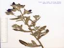
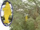
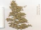
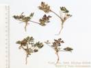
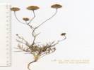
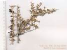
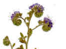
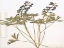
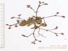
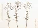
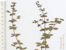
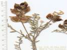
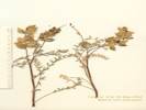
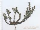
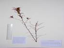
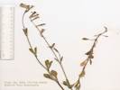
325 |
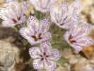
This one looks like a Phacelia, turns out to be an Echium.
Echium plantagineum L. Purple Viper's Bugloss. Bormujos, (Sevilla) Andalucia. In the neglected olive grove just west of the Hospital San Juan de Dios del Aljarafe, now (2013) the location of the elementary school CEIP Santo Domingo de Silos. 37.3723°N, 6.0858°W. WGS1984 Elev. 96 m. Coll. No. 325, 15 Feb 2004, characters observed while keying: Annual, to 35 cm.; Corolla, 23 mm., blue-purple, long hairs mostly on nerves, but also on margins of lobes (not short hairy throughout); Stamens, at least some exserted. Keyed with: Anthos. 2011. Sistema de información de las plantas de España. Real Jardín Botánico, CSIC- Fundación Biodiversidad. Recurso electrónico en www.anthos.es. Consulta realizada en marzo de 2011[Fecha de la consulta: 11 Sep 2013]. | ||||||||||||||||||||||||||||||||||||||||||||||||||||||||||||||||||||||||||||||||||||||||||||||||||||||||||||||||||||||||||||||||||||||||||||||||||||||||||||||||||||||||||||||||||||||||||||||||||||||||||||||||||||||||||||||||||||||||||||||||||||||||||||||||||||||||||||||||||||||||||||||||||||||||||||||||||||||||||||||||||||||||||||||||||||||||||||||||||||||||||||||||||||||||||||||||||||||||||||||||||||||||||||||||||||||||||||||||||||||||||||||||||||||||||||||||||||||||||||||||||||||||||||||||||||||||||||||||||||||||||||||||||||||||||||||||||||||||||||||||||||||||||||||||||||||||||||||||||||||||||||||||||||||||||||||||||||||||||||||||||||||||||||
|
Literature Cited:
|
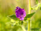
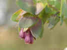
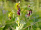
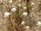
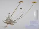
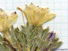
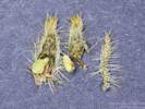
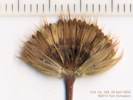
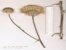
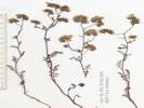
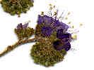
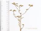
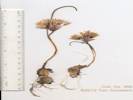
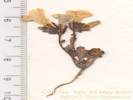
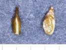
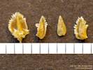
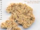
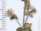
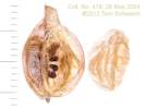
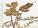
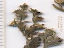
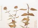
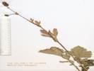
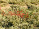
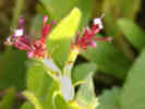
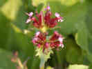
326 |
Typically the species is described as having yellow flowers (Polunin and Smythies, 1973). However, the plants in Bormujos had purplish flowers. There is a cultivar typically called C. major 'Purpurescens' that is commonly found on the Internet, or possibly a variety C. major var. purpurescens Boiss. which is described as having purple flowers, bracts and foliage (Polunin and Huxley, 1966). IPNI (http://www.ipni.org/) does not list var. purpurescens as being published and therefore it may be that 'Purpurescens' is simply a cultivar. The plants I collected in Bormujos do not fit neatly into the species or into cultivar 'Purpurescens' as it looks to be intermediate between the two or perhaps something different. | ||||||||||||||||||||||||||||||||||||||||||||||||||||||||||||||||||||||||||||||||||||||||||||||||||||||||||||||||||||||||||||||||||||||||||||||||||||||||||||||||||||||||||||||||||||||||||||||||||||||||||||||||||||||||||||||||||||||||||||||||||||||||||||||||||||||||||||||||||||||||||||||||||||||||||||||||||||||||||||||||||||||||||||||||||||||||||||||||||||||||||||||||||||||||||||||||||||||||||||||||||||||||||||||||||||||||||||||||||||||||||||||||||||||||||||||||||||||||||||||||||||||||||||||||||||||||||||||||||||||||||||||||||||||||||||||||||||||||||||||||||||||||||||||||||||||||||||||||||||||||||||||||||||||||||||||||||||||||||||||||||||||||||||
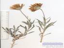
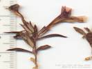
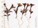
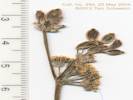
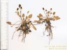
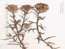
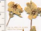
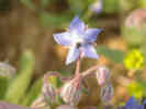 Borago officinalis L. in Bormujos (Sevilla), Spain Borago officinalis L. in Bormujos (Sevilla), Spain
 Borago officinalis L. in Bormujos (Sevilla), Spain Borago officinalis L. in Bormujos (Sevilla), Spain
|
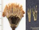
327 | Borago Officinalis L. | ||||||||||||||||||||||||||||||||||||||||||||||||||||||||||||||||||||||||||||||||||||||||||||||||||||||||||||||||||||||||||||||||||||||||||||||||||||||||||||||||||||||||||||||||||||||||||||||||||||||||||||||||||||||||||||||||||||||||||||||||||||||||||||||||||||||||||||||||||||||||||||||||||||||||||||||||||||||||||||||||||||||||||||||||||||||||||||||||||||||||||||||||||||||||||||||||||||||||||||||||||||||||||||||||||||||||||||||||||||||||||||||||||||||||||||||||||||||||||||||||||||||||||||||||||||||||||||||||||||||||||||||||||||||||||||||||||||||||||||||||||||||||||||||||||||||||||||||||||||||||||||||||||||||||||||||||||||||||||||||||||||||||||||
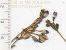
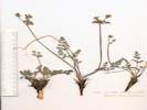
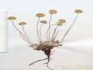
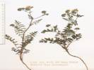
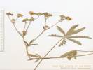
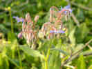
 Fedia cornucopiae (L.) Gaertner in Bormujos (Sevilla), Spain Fedia cornucopiae (L.) Gaertner in Bormujos (Sevilla), Spain
 Fedia cornucopiae (L.) Gaertner in Bormujos (Sevilla), Spain Fedia cornucopiae (L.) Gaertner in Bormujos (Sevilla), Spain
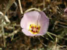
|
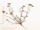
328 | Fedia cornucopiae (L.) Gaertner in Bormujos (Sevilla), Spain | ||||||||||||||||||||||||||||||||||||||||||||||||||||||||||||||||||||||||||||||||||||||||||||||||||||||||||||||||||||||||||||||||||||||||||||||||||||||||||||||||||||||||||||||||||||||||||||||||||||||||||||||||||||||||||||||||||||||||||||||||||||||||||||||||||||||||||||||||||||||||||||||||||||||||||||||||||||||||||||||||||||||||||||||||||||||||||||||||||||||||||||||||||||||||||||||||||||||||||||||||||||||||||||||||||||||||||||||||||||||||||||||||||||||||||||||||||||||||||||||||||||||||||||||||||||||||||||||||||||||||||||||||||||||||||||||||||||||||||||||||||||||||||||||||||||||||||||||||||||||||||||||||||||||||||||||||||||||||||||||||||||||||||||
| In the evening we had dinner with Nacho's parents. There was lots of talk about names for the baby, and other domestic things. I had honey roast lamb that tasted good, but was either too much or too late, as we finished dinner at 1130 PM, and I had a slight bit of discomfort through the night. | ||||||||||||||||||||||||||||||||||||||||||||||||||||||||||||||||||||||||||||||||||||||||||||||||||||||||||||||||||||||||||||||||||||||||||||||||||||||||||||||||||||||||||||||||||||||||||||||||||||||||||||||||||||||||||||||||||||||||||||||||||||||||||||||||||||||||||||||||||||||||||||||||||||||||||||||||||||||||||||||||||||||||||||||||||||||||||||||||||||||||||||||||||||||||||||||||||||||||||||||||||||||||||||||||||||||||||||||||||||||||||||||||||||||||||||||||||||||||||||||||||||||||||||||||||||||||||||||||||||||||||||||||||||||||||||||||||||||||||||||||||||||||||||||||||||||||||||||||||||||||||||||||||||||||||||||||||||||||||||||||||||||||||||||
|
|
Monday February 16th. Rachel's birthday. | |||||||||||||||||||||||||||||||||||||||||||||||||||||||||||||||||||||||||||||||||||||||||||||||||||||||||||||||||||||||||||||||||||||||||||||||||||||||||||||||||||||||||||||||||||||||||||||||||||||||||||||||||||||||||||||||||||||||||||||||||||||||||||||||||||||||||||||||||||||||||||||||||||||||||||||||||||||||||||||||||||||||||||||||||||||||||||||||||||||||||||||||||||||||||||||||||||||||||||||||||||||||||||||||||||||||||||||||||||||||||||||||||||||||||||||||||||||||||||||||||||||||||||||||||||||||||||||||||||||||||||||||||||||||||||||||||||||||||||||||||||||||||||||||||||||||||||||||||||||||||||||||||||||||||||||||||||||||||||||||||||||||||||||
| This morning the workmen are finishing the back of the neighbor's shed. They use mortar to finish the brickwork, and they added some bricks to keep the water from getting in between the little pump house and the neighbor's garden shed. | ||||||||||||||||||||||||||||||||||||||||||||||||||||||||||||||||||||||||||||||||||||||||||||||||||||||||||||||||||||||||||||||||||||||||||||||||||||||||||||||||||||||||||||||||||||||||||||||||||||||||||||||||||||||||||||||||||||||||||||||||||||||||||||||||||||||||||||||||||||||||||||||||||||||||||||||||||||||||||||||||||||||||||||||||||||||||||||||||||||||||||||||||||||||||||||||||||||||||||||||||||||||||||||||||||||||||||||||||||||||||||||||||||||||||||||||||||||||||||||||||||||||||||||||||||||||||||||||||||||||||||||||||||||||||||||||||||||||||||||||||||||||||||||||||||||||||||||||||||||||||||||||||||||||||||||||||||||||||||||||||||||||||||||||
 Rachel's birthday dinner. Rachel's birthday dinner.
|
Cheryl and Rachel made a lemon pie to celebrate my Rachel's birthday. Then they started making the spaghetti using the Lawrey's spaghetti sauce mix that we brought with us. | |||||||||||||||||||||||||||||||||||||||||||||||||||||||||||||||||||||||||||||||||||||||||||||||||||||||||||||||||||||||||||||||||||||||||||||||||||||||||||||||||||||||||||||||||||||||||||||||||||||||||||||||||||||||||||||||||||||||||||||||||||||||||||||||||||||||||||||||||||||||||||||||||||||||||||||||||||||||||||||||||||||||||||||||||||||||||||||||||||||||||||||||||||||||||||||||||||||||||||||||||||||||||||||||||||||||||||||||||||||||||||||||||||||||||||||||||||||||||||||||||||||||||||||||||||||||||||||||||||||||||||||||||||||||||||||||||||||||||||||||||||||||||||||||||||||||||||||||||||||||||||||||||||||||||||||||||||||||||||||||||||||||||||||
 Card from barbershop. Card from barbershop.
|
I went out to the barber shop "Peliqueria de Caballero" and got my hair cut. Requested "dos millimetros sobre todo" and the barber did pretty well. Looks just like a haircut in the US. | |||||||||||||||||||||||||||||||||||||||||||||||||||||||||||||||||||||||||||||||||||||||||||||||||||||||||||||||||||||||||||||||||||||||||||||||||||||||||||||||||||||||||||||||||||||||||||||||||||||||||||||||||||||||||||||||||||||||||||||||||||||||||||||||||||||||||||||||||||||||||||||||||||||||||||||||||||||||||||||||||||||||||||||||||||||||||||||||||||||||||||||||||||||||||||||||||||||||||||||||||||||||||||||||||||||||||||||||||||||||||||||||||||||||||||||||||||||||||||||||||||||||||||||||||||||||||||||||||||||||||||||||||||||||||||||||||||||||||||||||||||||||||||||||||||||||||||||||||||||||||||||||||||||||||||||||||||||||||||||||||||||||||||||
| I also stopped at a paper shop and bought a Spanish birthday card for Rachel. The words look like they are appropriate; I hope they turn out to be so. | ||||||||||||||||||||||||||||||||||||||||||||||||||||||||||||||||||||||||||||||||||||||||||||||||||||||||||||||||||||||||||||||||||||||||||||||||||||||||||||||||||||||||||||||||||||||||||||||||||||||||||||||||||||||||||||||||||||||||||||||||||||||||||||||||||||||||||||||||||||||||||||||||||||||||||||||||||||||||||||||||||||||||||||||||||||||||||||||||||||||||||||||||||||||||||||||||||||||||||||||||||||||||||||||||||||||||||||||||||||||||||||||||||||||||||||||||||||||||||||||||||||||||||||||||||||||||||||||||||||||||||||||||||||||||||||||||||||||||||||||||||||||||||||||||||||||||||||||||||||||||||||||||||||||||||||||||||||||||||||||||||||||||||||||
| This afternoon, after siesta, we went out to look for at plants in nurseries. We went to one nursery in Gines, the town just across the freeway. It took a little while to find because the map showed a bridge across the freeway that we had not noticed before. It was just a one-lane country bridge, and not made for lots of traffic. Then the nursery was down a long driveway. They did not have too much stock and said that their first shipment was expected at the end of this week. They did have the Eureka lemons, like the dwarf lemon tree that Cheryl is growing on our back deck. | ||||||||||||||||||||||||||||||||||||||||||||||||||||||||||||||||||||||||||||||||||||||||||||||||||||||||||||||||||||||||||||||||||||||||||||||||||||||||||||||||||||||||||||||||||||||||||||||||||||||||||||||||||||||||||||||||||||||||||||||||||||||||||||||||||||||||||||||||||||||||||||||||||||||||||||||||||||||||||||||||||||||||||||||||||||||||||||||||||||||||||||||||||||||||||||||||||||||||||||||||||||||||||||||||||||||||||||||||||||||||||||||||||||||||||||||||||||||||||||||||||||||||||||||||||||||||||||||||||||||||||||||||||||||||||||||||||||||||||||||||||||||||||||||||||||||||||||||||||||||||||||||||||||||||||||||||||||||||||||||||||||||||||||||
| From there we went to Bollullos because Nacho thought there was a nursery there. Bollullos is a little farther west (away from Sevilla), and a little farther south of the highway to Huelva. There was a nursery there, "Vivero Los Azahares," (www.los-azahares.com), but it is closed on Mondays. So we drove through Bollullos and into Umbrete to a garden and farm equipment store. There Nacho got an estimate for a lawn sprinkler system. The estimates are still given in Pesetas in addition to Euros. Maybe that is to help people understand how much things cost. | ||||||||||||||||||||||||||||||||||||||||||||||||||||||||||||||||||||||||||||||||||||||||||||||||||||||||||||||||||||||||||||||||||||||||||||||||||||||||||||||||||||||||||||||||||||||||||||||||||||||||||||||||||||||||||||||||||||||||||||||||||||||||||||||||||||||||||||||||||||||||||||||||||||||||||||||||||||||||||||||||||||||||||||||||||||||||||||||||||||||||||||||||||||||||||||||||||||||||||||||||||||||||||||||||||||||||||||||||||||||||||||||||||||||||||||||||||||||||||||||||||||||||||||||||||||||||||||||||||||||||||||||||||||||||||||||||||||||||||||||||||||||||||||||||||||||||||||||||||||||||||||||||||||||||||||||||||||||||||||||||||||||||||||||
| On our return to the house, we got some dinner, and then watched the news on TV. | ||||||||||||||||||||||||||||||||||||||||||||||||||||||||||||||||||||||||||||||||||||||||||||||||||||||||||||||||||||||||||||||||||||||||||||||||||||||||||||||||||||||||||||||||||||||||||||||||||||||||||||||||||||||||||||||||||||||||||||||||||||||||||||||||||||||||||||||||||||||||||||||||||||||||||||||||||||||||||||||||||||||||||||||||||||||||||||||||||||||||||||||||||||||||||||||||||||||||||||||||||||||||||||||||||||||||||||||||||||||||||||||||||||||||||||||||||||||||||||||||||||||||||||||||||||||||||||||||||||||||||||||||||||||||||||||||||||||||||||||||||||||||||||||||||||||||||||||||||||||||||||||||||||||||||||||||||||||||||||||||||||||||||||||
|
|
Tuesday, February 17th. | |||||||||||||||||||||||||||||||||||||||||||||||||||||||||||||||||||||||||||||||||||||||||||||||||||||||||||||||||||||||||||||||||||||||||||||||||||||||||||||||||||||||||||||||||||||||||||||||||||||||||||||||||||||||||||||||||||||||||||||||||||||||||||||||||||||||||||||||||||||||||||||||||||||||||||||||||||||||||||||||||||||||||||||||||||||||||||||||||||||||||||||||||||||||||||||||||||||||||||||||||||||||||||||||||||||||||||||||||||||||||||||||||||||||||||||||||||||||||||||||||||||||||||||||||||||||||||||||||||||||||||||||||||||||||||||||||||||||||||||||||||||||||||||||||||||||||||||||||||||||||||||||||||||||||||||||||||||||||||||||||||||||||||||
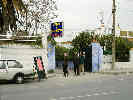
| This morning we got up a little earlier as we are going into Sevilla with Rachel. After breakfast we walked over to the bus stop, where we caught the bus to Sevilla from Bormujos. It's more like a commuter bus than a city bus, with upholstered forward-facing seats. You can buy a ticket that gives 10 rides into or out of the city with a transfer in the city. Unfortunately, the only place to buy the tickets is in the city. All three of us were able to ride on Rachel's one ticket. Just before crossing the river into Sevilla, we got off and transferred to another bus that ran through Triana and Los Remedios before crossing the river into the city. We got off this bus as soon as we crossed the river, and then walked through one end of the Parque Maria Luisa to the street where Rachel works, Calle Felipe II (Felipe Segunda). | ||||||||||||||||||||||||||||||||||||||||||||||||||||||||||||||||||||||||||||||||||||||||||||||||||||||||||||||||||||||||||||||||||||||||||||||||||||||||||||||||||||||||||||||||||||||||||||||||||||||||||||||||||||||||||||||||||||||||||||||||||||||||||||||||||||||||||||||||||||||||||||||||||||||||||||||||||||||||||||||||||||||||||||||||||||||||||||||||||||||||||||||||||||||||||||||||||||||||||||||||||||||||||||||||||||||||||||||||||||||||||||||||||||||||||||||||||||||||||||||||||||||||||||||||||||||||||||||||||||||||||||||||||||||||||||||||||||||||||||||||||||||||||||||||||||||||||||||||||||||||||||||||||||||||||||||||||||||||||||||||||||||||||||||
| We visited her school, TEFL International, which it shares with the English Institute, and met Chris, one of the teachers, then went a short way up the street to buy bus tickets in a Tobacco shop. I think it was about 10 for the Bormujos-Sevilla bus ticket, and 3.80 for 10-ride ticket for use just within Sevilla. | ||||||||||||||||||||||||||||||||||||||||||||||||||||||||||||||||||||||||||||||||||||||||||||||||||||||||||||||||||||||||||||||||||||||||||||||||||||||||||||||||||||||||||||||||||||||||||||||||||||||||||||||||||||||||||||||||||||||||||||||||||||||||||||||||||||||||||||||||||||||||||||||||||||||||||||||||||||||||||||||||||||||||||||||||||||||||||||||||||||||||||||||||||||||||||||||||||||||||||||||||||||||||||||||||||||||||||||||||||||||||||||||||||||||||||||||||||||||||||||||||||||||||||||||||||||||||||||||||||||||||||||||||||||||||||||||||||||||||||||||||||||||||||||||||||||||||||||||||||||||||||||||||||||||||||||||||||||||||||||||||||||||||||||||
| We left Rachel to work, then walked down the street to a book store. I was hoping to find Polunin's "Flowers of South-West Europe." They didn't have it. They did have a Flowers of Europe by Polunin in Spanish, but the identification key was in Spanish, and I did not think I could follow the key. They also had aerial photographs of Andalucia, and of the National Parks of Andalucia. Anyway, we did not get any thing at the bookstore. | ||||||||||||||||||||||||||||||||||||||||||||||||||||||||||||||||||||||||||||||||||||||||||||||||||||||||||||||||||||||||||||||||||||||||||||||||||||||||||||||||||||||||||||||||||||||||||||||||||||||||||||||||||||||||||||||||||||||||||||||||||||||||||||||||||||||||||||||||||||||||||||||||||||||||||||||||||||||||||||||||||||||||||||||||||||||||||||||||||||||||||||||||||||||||||||||||||||||||||||||||||||||||||||||||||||||||||||||||||||||||||||||||||||||||||||||||||||||||||||||||||||||||||||||||||||||||||||||||||||||||||||||||||||||||||||||||||||||||||||||||||||||||||||||||||||||||||||||||||||||||||||||||||||||||||||||||||||||||||||||||||||||||||||||
| Back on the street, we caught the number 30 bus that runs into the city center at Plaza Nueva. We walked up to Sierpes (as in "serpent" as it is a twisting shopping street), and got a Cafe con Leche. Then we did a little bit of shopping before arriving at El Corte Ingles (Spain's big department store). We bought some red thread to match Rachel's red curtains, and asked about sewing machines (maquinas de coser). Cheryl wants to have a sewing machine available when she is here in the summer. The sewing machines were in a different building, and the clerk tried to show me on the map where it was. As we were leaving the store, we saw another map showing where the other building was ... down the street, thru the alley, jog left, another narrow street, jog right, thru the plaza ... etc. No streets, of course, are straight, and some are only a block long. | ||||||||||||||||||||||||||||||||||||||||||||||||||||||||||||||||||||||||||||||||||||||||||||||||||||||||||||||||||||||||||||||||||||||||||||||||||||||||||||||||||||||||||||||||||||||||||||||||||||||||||||||||||||||||||||||||||||||||||||||||||||||||||||||||||||||||||||||||||||||||||||||||||||||||||||||||||||||||||||||||||||||||||||||||||||||||||||||||||||||||||||||||||||||||||||||||||||||||||||||||||||||||||||||||||||||||||||||||||||||||||||||||||||||||||||||||||||||||||||||||||||||||||||||||||||||||||||||||||||||||||||||||||||||||||||||||||||||||||||||||||||||||||||||||||||||||||||||||||||||||||||||||||||||||||||||||||||||||||||||||||||||||||||||
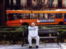 Tom holds the sewing machine in Plaza Nueva. Tom holds the sewing machine in Plaza Nueva.
|
Anyway we found the other El Corte Ingles building, and the sewing machines upstairs. They had a basic model with a few features that Cheryl wanted. When we asked to buy it, they brought out a different model. It was close; it was model 1416 when we had picked out model 1406. We had some discussion in Spanish. The thing is that early in the year all the stores have sales (rebajas), and they are very predictable, but not necessarily clearance sales. For the sewing machine model we picked out was last year's model and therefore not on sale, but the model the salesman brought out was a new model on sale (nuevo modelo en rebaja). He even took the new 1416 model out of the box to show us feature by feature that it was the same as the 1406 model. So we bought it. The salesman made a very clever carrying handle out of tape, and we set forth thru the narrow city streets with sewing machine in hand. | |||||||||||||||||||||||||||||||||||||||||||||||||||||||||||||||||||||||||||||||||||||||||||||||||||||||||||||||||||||||||||||||||||||||||||||||||||||||||||||||||||||||||||||||||||||||||||||||||||||||||||||||||||||||||||||||||||||||||||||||||||||||||||||||||||||||||||||||||||||||||||||||||||||||||||||||||||||||||||||||||||||||||||||||||||||||||||||||||||||||||||||||||||||||||||||||||||||||||||||||||||||||||||||||||||||||||||||||||||||||||||||||||||||||||||||||||||||||||||||||||||||||||||||||||||||||||||||||||||||||||||||||||||||||||||||||||||||||||||||||||||||||||||||||||||||||||||||||||||||||||||||||||||||||||||||||||||||||||||||||||||||||||||||
| Back at Plaza Nueva, we sat and watched people for a while, then boarded the 33 bus. Less than 15 minutes later we got off at C/ Felipe II, the street of Rachel's school. Nacho came from work a few minutes later, and we drove to Bormujos for lunch. After a short siesta, Nacho is preparing for the class he teaches tonight. While I write this, Rachel is training Cheryl to operate the washing machine. Not sure what we're doing this afternoon; perhaps walking to the fruit store in downtown Bormujos. Rachel is also showing Cheryl how to operate the stroller that Nacho bought when he was in the US for his recent class. | ||||||||||||||||||||||||||||||||||||||||||||||||||||||||||||||||||||||||||||||||||||||||||||||||||||||||||||||||||||||||||||||||||||||||||||||||||||||||||||||||||||||||||||||||||||||||||||||||||||||||||||||||||||||||||||||||||||||||||||||||||||||||||||||||||||||||||||||||||||||||||||||||||||||||||||||||||||||||||||||||||||||||||||||||||||||||||||||||||||||||||||||||||||||||||||||||||||||||||||||||||||||||||||||||||||||||||||||||||||||||||||||||||||||||||||||||||||||||||||||||||||||||||||||||||||||||||||||||||||||||||||||||||||||||||||||||||||||||||||||||||||||||||||||||||||||||||||||||||||||||||||||||||||||||||||||||||||||||||||||||||||||||||||||
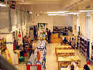 Interior of the Library in Bormujos Interior of the Library in Bormujos
|
The library in Bormujos | |||||||||||||||||||||||||||||||||||||||||||||||||||||||||||||||||||||||||||||||||||||||||||||||||||||||||||||||||||||||||||||||||||||||||||||||||||||||||||||||||||||||||||||||||||||||||||||||||||||||||||||||||||||||||||||||||||||||||||||||||||||||||||||||||||||||||||||||||||||||||||||||||||||||||||||||||||||||||||||||||||||||||||||||||||||||||||||||||||||||||||||||||||||||||||||||||||||||||||||||||||||||||||||||||||||||||||||||||||||||||||||||||||||||||||||||||||||||||||||||||||||||||||||||||||||||||||||||||||||||||||||||||||||||||||||||||||||||||||||||||||||||||||||||||||||||||||||||||||||||||||||||||||||||||||||||||||||||||||||||||||||||||||||
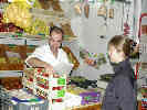 Buying strawberries at the market. Buying strawberries at the market.
|
Buying Strawberries | |||||||||||||||||||||||||||||||||||||||||||||||||||||||||||||||||||||||||||||||||||||||||||||||||||||||||||||||||||||||||||||||||||||||||||||||||||||||||||||||||||||||||||||||||||||||||||||||||||||||||||||||||||||||||||||||||||||||||||||||||||||||||||||||||||||||||||||||||||||||||||||||||||||||||||||||||||||||||||||||||||||||||||||||||||||||||||||||||||||||||||||||||||||||||||||||||||||||||||||||||||||||||||||||||||||||||||||||||||||||||||||||||||||||||||||||||||||||||||||||||||||||||||||||||||||||||||||||||||||||||||||||||||||||||||||||||||||||||||||||||||||||||||||||||||||||||||||||||||||||||||||||||||||||||||||||||||||||||||||||||||||||||||||
| Rachel went into Sevilla for her yoga class. | ||||||||||||||||||||||||||||||||||||||||||||||||||||||||||||||||||||||||||||||||||||||||||||||||||||||||||||||||||||||||||||||||||||||||||||||||||||||||||||||||||||||||||||||||||||||||||||||||||||||||||||||||||||||||||||||||||||||||||||||||||||||||||||||||||||||||||||||||||||||||||||||||||||||||||||||||||||||||||||||||||||||||||||||||||||||||||||||||||||||||||||||||||||||||||||||||||||||||||||||||||||||||||||||||||||||||||||||||||||||||||||||||||||||||||||||||||||||||||||||||||||||||||||||||||||||||||||||||||||||||||||||||||||||||||||||||||||||||||||||||||||||||||||||||||||||||||||||||||||||||||||||||||||||||||||||||||||||||||||||||||||||||||||||
|
|
Wednesday February 18th | |||||||||||||||||||||||||||||||||||||||||||||||||||||||||||||||||||||||||||||||||||||||||||||||||||||||||||||||||||||||||||||||||||||||||||||||||||||||||||||||||||||||||||||||||||||||||||||||||||||||||||||||||||||||||||||||||||||||||||||||||||||||||||||||||||||||||||||||||||||||||||||||||||||||||||||||||||||||||||||||||||||||||||||||||||||||||||||||||||||||||||||||||||||||||||||||||||||||||||||||||||||||||||||||||||||||||||||||||||||||||||||||||||||||||||||||||||||||||||||||||||||||||||||||||||||||||||||||||||||||||||||||||||||||||||||||||||||||||||||||||||||||||||||||||||||||||||||||||||||||||||||||||||||||||||||||||||||||||||||||||||||||||||||
| This morning Rachel is staying home for a little vacation. Cheryl and Rachel are cooking, bran muffins this time. They sent me to the supermarket to buy a few things. One of the things I had to get was lowfat milk. Unfortunately, I was going by the color of the cap on the milk jug rather than reading the labels. The milk from Asturias has a blue cap on the low fat milk. But the other brand of milk has a blue cap on the whole milk. Well, I bought milk with a blue cap, but it was the wrong brand, so I bought whole milk instead of low fat milk. In Spain, they irradiate the milk, so it doesn't have to be refrigerated until it is opened. Next on my list were eggs; that was pretty easy. Last was dried apricots ("orejones albaricoques"). Fortunately, Rachel had written this down, and I did not have to say it to the clerk I asked. He said a long speech, but I got the "fruteria" part so I assumed they were with the fresh fruit. And they were, just off to one side a little bit. Cheryl also wanted some buttermilk, but Rachel had no idea what that might be. | ||||||||||||||||||||||||||||||||||||||||||||||||||||||||||||||||||||||||||||||||||||||||||||||||||||||||||||||||||||||||||||||||||||||||||||||||||||||||||||||||||||||||||||||||||||||||||||||||||||||||||||||||||||||||||||||||||||||||||||||||||||||||||||||||||||||||||||||||||||||||||||||||||||||||||||||||||||||||||||||||||||||||||||||||||||||||||||||||||||||||||||||||||||||||||||||||||||||||||||||||||||||||||||||||||||||||||||||||||||||||||||||||||||||||||||||||||||||||||||||||||||||||||||||||||||||||||||||||||||||||||||||||||||||||||||||||||||||||||||||||||||||||||||||||||||||||||||||||||||||||||||||||||||||||||||||||||||||||||||||||||||||||||||||
|
Locations:
Bormujos.
|
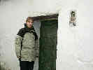
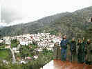
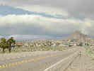
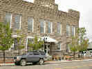
After delivering the groceries, I set forth for a walk around town. I covered most of it, and sent the photos yesterday. The city hall is on the main street of town in about the middle. | |||||||||||||||||||||||||||||||||||||||||||||||||||||||||||||||||||||||||||||||||||||||||||||||||||||||||||||||||||||||||||||||||||||||||||||||||||||||||||||||||||||||||||||||||||||||||||||||||||||||||||||||||||||||||||||||||||||||||||||||||||||||||||||||||||||||||||||||||||||||||||||||||||||||||||||||||||||||||||||||||||||||||||||||||||||||||||||||||||||||||||||||||||||||||||||||||||||||||||||||||||||||||||||||||||||||||||||||||||||||||||||||||||||||||||||||||||||||||||||||||||||||||||||||||||||||||||||||||||||||||||||||||||||||||||||||||||||||||||||||||||||||||||||||||||||||||||||||||||||||||||||||||||||||||||||||||||||||||||||||||||||||||||||
|
Locations:
Bormujos.
|
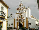
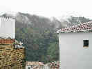
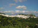
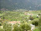
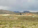
Below it is the older town with the narrow streets and the church. | |||||||||||||||||||||||||||||||||||||||||||||||||||||||||||||||||||||||||||||||||||||||||||||||||||||||||||||||||||||||||||||||||||||||||||||||||||||||||||||||||||||||||||||||||||||||||||||||||||||||||||||||||||||||||||||||||||||||||||||||||||||||||||||||||||||||||||||||||||||||||||||||||||||||||||||||||||||||||||||||||||||||||||||||||||||||||||||||||||||||||||||||||||||||||||||||||||||||||||||||||||||||||||||||||||||||||||||||||||||||||||||||||||||||||||||||||||||||||||||||||||||||||||||||||||||||||||||||||||||||||||||||||||||||||||||||||||||||||||||||||||||||||||||||||||||||||||||||||||||||||||||||||||||||||||||||||||||||||||||||||||||||||||||
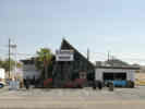
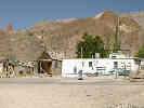
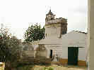 Hacienda Belen, Bormujos Olive Plant. Hacienda Belen, Bormujos Olive Plant.
|
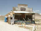
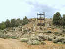
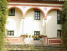
Towards the west end of the old town is Hacienda Belen, where they used to bring the olives for pressing and preserving. Outside the hacienda are three old ollas, that were used to store olive oil after pressing. | |||||||||||||||||||||||||||||||||||||||||||||||||||||||||||||||||||||||||||||||||||||||||||||||||||||||||||||||||||||||||||||||||||||||||||||||||||||||||||||||||||||||||||||||||||||||||||||||||||||||||||||||||||||||||||||||||||||||||||||||||||||||||||||||||||||||||||||||||||||||||||||||||||||||||||||||||||||||||||||||||||||||||||||||||||||||||||||||||||||||||||||||||||||||||||||||||||||||||||||||||||||||||||||||||||||||||||||||||||||||||||||||||||||||||||||||||||||||||||||||||||||||||||||||||||||||||||||||||||||||||||||||||||||||||||||||||||||||||||||||||||||||||||||||||||||||||||||||||||||||||||||||||||||||||||||||||||||||||||||||||||||||||||||
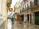
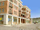
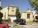
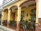 House on C/ Pablo Cosso Calero, the main street of Bormujos. House on C/ Pablo Cosso Calero, the main street of Bormujos.
|
The building is quite run down now, but it seems to be in use for some purpose. Most of the houses in town were one or two stories. The roofs were flat, and many houses had stairs giving access to the roof, where there was often a clothesline. Many of the houses were decorated with tile around the doors and windows. | |||||||||||||||||||||||||||||||||||||||||||||||||||||||||||||||||||||||||||||||||||||||||||||||||||||||||||||||||||||||||||||||||||||||||||||||||||||||||||||||||||||||||||||||||||||||||||||||||||||||||||||||||||||||||||||||||||||||||||||||||||||||||||||||||||||||||||||||||||||||||||||||||||||||||||||||||||||||||||||||||||||||||||||||||||||||||||||||||||||||||||||||||||||||||||||||||||||||||||||||||||||||||||||||||||||||||||||||||||||||||||||||||||||||||||||||||||||||||||||||||||||||||||||||||||||||||||||||||||||||||||||||||||||||||||||||||||||||||||||||||||||||||||||||||||||||||||||||||||||||||||||||||||||||||||||||||||||||||||||||||||||||||||||
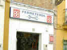 Hardware Store in Bormujos Hardware Store in Bormujos
|
At the hardware store, we bought Nacho a pair of diagonal wire cutters for the next time he needs to work on the fence. | |||||||||||||||||||||||||||||||||||||||||||||||||||||||||||||||||||||||||||||||||||||||||||||||||||||||||||||||||||||||||||||||||||||||||||||||||||||||||||||||||||||||||||||||||||||||||||||||||||||||||||||||||||||||||||||||||||||||||||||||||||||||||||||||||||||||||||||||||||||||||||||||||||||||||||||||||||||||||||||||||||||||||||||||||||||||||||||||||||||||||||||||||||||||||||||||||||||||||||||||||||||||||||||||||||||||||||||||||||||||||||||||||||||||||||||||||||||||||||||||||||||||||||||||||||||||||||||||||||||||||||||||||||||||||||||||||||||||||||||||||||||||||||||||||||||||||||||||||||||||||||||||||||||||||||||||||||||||||||||||||||||||||||||
| At one house that I liked, the woman was washing the step, so I was waiting to take a photo by looking at the photos of houses for sale in the window of a real estate office. A very earnest young man came out to greet me and help me find me dream house, but eventually we decided that I was truly only looking and not planning to buy. | ||||||||||||||||||||||||||||||||||||||||||||||||||||||||||||||||||||||||||||||||||||||||||||||||||||||||||||||||||||||||||||||||||||||||||||||||||||||||||||||||||||||||||||||||||||||||||||||||||||||||||||||||||||||||||||||||||||||||||||||||||||||||||||||||||||||||||||||||||||||||||||||||||||||||||||||||||||||||||||||||||||||||||||||||||||||||||||||||||||||||||||||||||||||||||||||||||||||||||||||||||||||||||||||||||||||||||||||||||||||||||||||||||||||||||||||||||||||||||||||||||||||||||||||||||||||||||||||||||||||||||||||||||||||||||||||||||||||||||||||||||||||||||||||||||||||||||||||||||||||||||||||||||||||||||||||||||||||||||||||||||||||||||||||
| In the afternoon, we did some more shopping for landscaping supplies and plants. We went to a "polvero" (a dust place) in Gines to ask about bringing in some decent dirt to support a small lawn. Nacho calculated he needs 4.25 cubic meters. You have to call the day before you want it and they dump it in the street, which means Nacho will also need a wheel barrow and a shovel. | ||||||||||||||||||||||||||||||||||||||||||||||||||||||||||||||||||||||||||||||||||||||||||||||||||||||||||||||||||||||||||||||||||||||||||||||||||||||||||||||||||||||||||||||||||||||||||||||||||||||||||||||||||||||||||||||||||||||||||||||||||||||||||||||||||||||||||||||||||||||||||||||||||||||||||||||||||||||||||||||||||||||||||||||||||||||||||||||||||||||||||||||||||||||||||||||||||||||||||||||||||||||||||||||||||||||||||||||||||||||||||||||||||||||||||||||||||||||||||||||||||||||||||||||||||||||||||||||||||||||||||||||||||||||||||||||||||||||||||||||||||||||||||||||||||||||||||||||||||||||||||||||||||||||||||||||||||||||||||||||||||||||||||||||
 Vivero "La Menara" Vivero "La Menara"
|
Just up the street from the "polvero" was the "Vivero La Menara" or nursery. This was a very good one, with both fresh and mature stock. They had several species of what we would call "locust trees," but none that I would identify as the Robinia pseudo-acacia that we plant in the US. One tree was listed as a Catalpa but not otherwise identified as to species. I was interested in the Catalpa because the Desert Willow (Chilopsis linearis) that I see in the Eastern Mojave may be in the same genus depending upon what is meant by Catalpa. I think also that the tree stock in the nurseries is much more mature that those a US nursery sells, perhaps 7-8 years, and heavily pruned, whereas I think US nurseries mostly sell younger trees that have not been pruned. | |||||||||||||||||||||||||||||||||||||||||||||||||||||||||||||||||||||||||||||||||||||||||||||||||||||||||||||||||||||||||||||||||||||||||||||||||||||||||||||||||||||||||||||||||||||||||||||||||||||||||||||||||||||||||||||||||||||||||||||||||||||||||||||||||||||||||||||||||||||||||||||||||||||||||||||||||||||||||||||||||||||||||||||||||||||||||||||||||||||||||||||||||||||||||||||||||||||||||||||||||||||||||||||||||||||||||||||||||||||||||||||||||||||||||||||||||||||||||||||||||||||||||||||||||||||||||||||||||||||||||||||||||||||||||||||||||||||||||||||||||||||||||||||||||||||||||||||||||||||||||||||||||||||||||||||||||||||||||||||||||||||||||||||
 Thinking about trees in Vivero "La Menara" Thinking about trees in Vivero "La Menara"
|
I think Nacho and Rachel are settling on a Granado (pomegranate), a peach (melocoton) tree and a lemon tree. Since they don't have a lot of space, it would make sense to select trees that also gave fruit back. We also drove back to the nursery in Bollullos "Vivero Los Azahares," and took a look there. This nursery did not have so many trees, but it did have a good selection of smaller shrubs. Here, I learned that vines are called "rampantes" somewhat like the English adjective "rampant," meaning growing or extending unchecked. They had some very nice Trumpet Vines, in the genus Bignonia, also related to the Catalpa and the Desert Willow. | |||||||||||||||||||||||||||||||||||||||||||||||||||||||||||||||||||||||||||||||||||||||||||||||||||||||||||||||||||||||||||||||||||||||||||||||||||||||||||||||||||||||||||||||||||||||||||||||||||||||||||||||||||||||||||||||||||||||||||||||||||||||||||||||||||||||||||||||||||||||||||||||||||||||||||||||||||||||||||||||||||||||||||||||||||||||||||||||||||||||||||||||||||||||||||||||||||||||||||||||||||||||||||||||||||||||||||||||||||||||||||||||||||||||||||||||||||||||||||||||||||||||||||||||||||||||||||||||||||||||||||||||||||||||||||||||||||||||||||||||||||||||||||||||||||||||||||||||||||||||||||||||||||||||||||||||||||||||||||||||||||||||||||||
|
Locations:
Bormujos.
|
We came back to Bormujos, and went to the library to get a book about trees. I think Nacho was looking for information about how big trees got, what they looked like, how to care for them, etc. The library did not have a book about trees, but he did get a book about garden planning. While Nacho looked for them, I perused the travel section, and found that there are many small books about places to go or things to do in Andalucia; books that we don't have access to in the US. | |||||||||||||||||||||||||||||||||||||||||||||||||||||||||||||||||||||||||||||||||||||||||||||||||||||||||||||||||||||||||||||||||||||||||||||||||||||||||||||||||||||||||||||||||||||||||||||||||||||||||||||||||||||||||||||||||||||||||||||||||||||||||||||||||||||||||||||||||||||||||||||||||||||||||||||||||||||||||||||||||||||||||||||||||||||||||||||||||||||||||||||||||||||||||||||||||||||||||||||||||||||||||||||||||||||||||||||||||||||||||||||||||||||||||||||||||||||||||||||||||||||||||||||||||||||||||||||||||||||||||||||||||||||||||||||||||||||||||||||||||||||||||||||||||||||||||||||||||||||||||||||||||||||||||||||||||||||||||||||||||||||||||||||
| For dinner, we finished off the spaghetti from Rachel's birthday dinner | ||||||||||||||||||||||||||||||||||||||||||||||||||||||||||||||||||||||||||||||||||||||||||||||||||||||||||||||||||||||||||||||||||||||||||||||||||||||||||||||||||||||||||||||||||||||||||||||||||||||||||||||||||||||||||||||||||||||||||||||||||||||||||||||||||||||||||||||||||||||||||||||||||||||||||||||||||||||||||||||||||||||||||||||||||||||||||||||||||||||||||||||||||||||||||||||||||||||||||||||||||||||||||||||||||||||||||||||||||||||||||||||||||||||||||||||||||||||||||||||||||||||||||||||||||||||||||||||||||||||||||||||||||||||||||||||||||||||||||||||||||||||||||||||||||||||||||||||||||||||||||||||||||||||||||||||||||||||||||||||||||||||||||||||
|
|
Thursday February 19th. | |||||||||||||||||||||||||||||||||||||||||||||||||||||||||||||||||||||||||||||||||||||||||||||||||||||||||||||||||||||||||||||||||||||||||||||||||||||||||||||||||||||||||||||||||||||||||||||||||||||||||||||||||||||||||||||||||||||||||||||||||||||||||||||||||||||||||||||||||||||||||||||||||||||||||||||||||||||||||||||||||||||||||||||||||||||||||||||||||||||||||||||||||||||||||||||||||||||||||||||||||||||||||||||||||||||||||||||||||||||||||||||||||||||||||||||||||||||||||||||||||||||||||||||||||||||||||||||||||||||||||||||||||||||||||||||||||||||||||||||||||||||||||||||||||||||||||||||||||||||||||||||||||||||||||||||||||||||||||||||||||||||||||||||
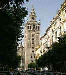 The Cathedral Tower with Giralda. The Cathedral Tower with Giralda.
|
This morning we got up a little early and rode the bus into Sevilla with Rachel. After arriving near her work, Rachel and Cheryl had breakfast (toast with oil and pureed tomato), while I had a coffee. We parted company, and Cheryl and I took a number 33 bus closer to the center of town, and then walked into Barrio Santa Cruz. We entered at Calle Agua where the town water supply was carried in the walls of the city. Then we wandered our way through the barrio -- the former Jewish ghetto of Sevilla -- coming out once at the Cathedral because I wanted to take a photograph of the Giralda at the top of the Cathedral tower. When I gave my talk about "Outdoors in Southern Spain" at UC, someone spoke up and pointed out that the tower of the Ferry Building in San Francisco was modeled after the Giralda Tower in Sevilla. It was first the tower of the mosque in Sevilla, but now is the tower for the Cathedral. | |||||||||||||||||||||||||||||||||||||||||||||||||||||||||||||||||||||||||||||||||||||||||||||||||||||||||||||||||||||||||||||||||||||||||||||||||||||||||||||||||||||||||||||||||||||||||||||||||||||||||||||||||||||||||||||||||||||||||||||||||||||||||||||||||||||||||||||||||||||||||||||||||||||||||||||||||||||||||||||||||||||||||||||||||||||||||||||||||||||||||||||||||||||||||||||||||||||||||||||||||||||||||||||||||||||||||||||||||||||||||||||||||||||||||||||||||||||||||||||||||||||||||||||||||||||||||||||||||||||||||||||||||||||||||||||||||||||||||||||||||||||||||||||||||||||||||||||||||||||||||||||||||||||||||||||||||||||||||||||||||||||||||||||
|
Other articles:
|
We ducked back into the barrio and found ourselves coming out at the intersection from whence we watched the Paso de San Bernardo enter the inner city during last year's Semana Santa. | |||||||||||||||||||||||||||||||||||||||||||||||||||||||||||||||||||||||||||||||||||||||||||||||||||||||||||||||||||||||||||||||||||||||||||||||||||||||||||||||||||||||||||||||||||||||||||||||||||||||||||||||||||||||||||||||||||||||||||||||||||||||||||||||||||||||||||||||||||||||||||||||||||||||||||||||||||||||||||||||||||||||||||||||||||||||||||||||||||||||||||||||||||||||||||||||||||||||||||||||||||||||||||||||||||||||||||||||||||||||||||||||||||||||||||||||||||||||||||||||||||||||||||||||||||||||||||||||||||||||||||||||||||||||||||||||||||||||||||||||||||||||||||||||||||||||||||||||||||||||||||||||||||||||||||||||||||||||||||||||||||||||||||||
 Courtyard in Barrio de Santa Cruz Courtyard in Barrio de Santa Cruz
|
After the paso went by last year we hurried thru the barrio, sort of in the direction of Rachel's house, and I remembered looking through a grille and seeing a wonderful courtyard garden. So we plunged back into the depths of the barrio and, by luck, went straight to the place. Looking at it at length this time, it now seems to be courtyard for a hotel, or a short-term residence. Still very nice and worth a photo. | |||||||||||||||||||||||||||||||||||||||||||||||||||||||||||||||||||||||||||||||||||||||||||||||||||||||||||||||||||||||||||||||||||||||||||||||||||||||||||||||||||||||||||||||||||||||||||||||||||||||||||||||||||||||||||||||||||||||||||||||||||||||||||||||||||||||||||||||||||||||||||||||||||||||||||||||||||||||||||||||||||||||||||||||||||||||||||||||||||||||||||||||||||||||||||||||||||||||||||||||||||||||||||||||||||||||||||||||||||||||||||||||||||||||||||||||||||||||||||||||||||||||||||||||||||||||||||||||||||||||||||||||||||||||||||||||||||||||||||||||||||||||||||||||||||||||||||||||||||||||||||||||||||||||||||||||||||||||||||||||||||||||||||||
| We wandered a bit and came out near the street where Rachel and Nacho used to live, Escuelas Pias, and the walked down to Plaza Ponce de Leon, where we got a Coke and rested a few minutes. | ||||||||||||||||||||||||||||||||||||||||||||||||||||||||||||||||||||||||||||||||||||||||||||||||||||||||||||||||||||||||||||||||||||||||||||||||||||||||||||||||||||||||||||||||||||||||||||||||||||||||||||||||||||||||||||||||||||||||||||||||||||||||||||||||||||||||||||||||||||||||||||||||||||||||||||||||||||||||||||||||||||||||||||||||||||||||||||||||||||||||||||||||||||||||||||||||||||||||||||||||||||||||||||||||||||||||||||||||||||||||||||||||||||||||||||||||||||||||||||||||||||||||||||||||||||||||||||||||||||||||||||||||||||||||||||||||||||||||||||||||||||||||||||||||||||||||||||||||||||||||||||||||||||||||||||||||||||||||||||||||||||||||||||||
| We went back up to the main street that follows the old city walls (so we were just outside the old city), and caught the No. 1 bus that took us to the street where Rachel works. | ||||||||||||||||||||||||||||||||||||||||||||||||||||||||||||||||||||||||||||||||||||||||||||||||||||||||||||||||||||||||||||||||||||||||||||||||||||||||||||||||||||||||||||||||||||||||||||||||||||||||||||||||||||||||||||||||||||||||||||||||||||||||||||||||||||||||||||||||||||||||||||||||||||||||||||||||||||||||||||||||||||||||||||||||||||||||||||||||||||||||||||||||||||||||||||||||||||||||||||||||||||||||||||||||||||||||||||||||||||||||||||||||||||||||||||||||||||||||||||||||||||||||||||||||||||||||||||||||||||||||||||||||||||||||||||||||||||||||||||||||||||||||||||||||||||||||||||||||||||||||||||||||||||||||||||||||||||||||||||||||||||||||||||||
| Nacho joined us for lunch, and we walked to a neighborhood bar for lunch. "Lunch" starts about 230 PM in the afternoon and goes until about 400 PM. It still seems a little strange to go to a bar for lunch. I mean, a BAR is a not-very-good place where not-very-good people hang out. But in Spain this is not so. This was a family bar, the father mostly ran the bar and did the out-front work, the mother mostly did the cooking and a little of the serving. Their older son, who looked to be about 13 helped out with the serving, and also made the coffees we had. The younger son, about 7 or 8, helped with carrying the cardboard boxes out. He also had taken over the chalkboard, intended to announce the menu of the day, to draw pictures on, by the time we left. We started with a salad of lettuce, tomato, onion (like yellow onion), and tuna, covered with oil and vinegar, and salted a bit. Nacho started with a potato stew with clams. Then, Rachel and Nacho had tuna that looked like it was braised with some onion, served with french fires, Cheryl had "espinacas" which is spinach cooked with garbanzos. I had chicken, like a boneless chicken breast, breaded and fried, that also came with a few french fries. Then we drove home. | ||||||||||||||||||||||||||||||||||||||||||||||||||||||||||||||||||||||||||||||||||||||||||||||||||||||||||||||||||||||||||||||||||||||||||||||||||||||||||||||||||||||||||||||||||||||||||||||||||||||||||||||||||||||||||||||||||||||||||||||||||||||||||||||||||||||||||||||||||||||||||||||||||||||||||||||||||||||||||||||||||||||||||||||||||||||||||||||||||||||||||||||||||||||||||||||||||||||||||||||||||||||||||||||||||||||||||||||||||||||||||||||||||||||||||||||||||||||||||||||||||||||||||||||||||||||||||||||||||||||||||||||||||||||||||||||||||||||||||||||||||||||||||||||||||||||||||||||||||||||||||||||||||||||||||||||||||||||||||||||||||||||||||||||
| It's now about 630 PM in Spain. While at home, it would be dinner time, in Spain it is pretty much mid-afternoon. Nacho has gone to the bank, and Cheryl and Rachel are hemming the upstairs curtains. | ||||||||||||||||||||||||||||||||||||||||||||||||||||||||||||||||||||||||||||||||||||||||||||||||||||||||||||||||||||||||||||||||||||||||||||||||||||||||||||||||||||||||||||||||||||||||||||||||||||||||||||||||||||||||||||||||||||||||||||||||||||||||||||||||||||||||||||||||||||||||||||||||||||||||||||||||||||||||||||||||||||||||||||||||||||||||||||||||||||||||||||||||||||||||||||||||||||||||||||||||||||||||||||||||||||||||||||||||||||||||||||||||||||||||||||||||||||||||||||||||||||||||||||||||||||||||||||||||||||||||||||||||||||||||||||||||||||||||||||||||||||||||||||||||||||||||||||||||||||||||||||||||||||||||||||||||||||||||||||||||||||||||||||||
| Tomorrow we are leaving for Jubrique. The next and probably last e-mail would be Sunday night or Monday morning, after we return from Jubrique, but before we go to Madrid for the flight home. | ||||||||||||||||||||||||||||||||||||||||||||||||||||||||||||||||||||||||||||||||||||||||||||||||||||||||||||||||||||||||||||||||||||||||||||||||||||||||||||||||||||||||||||||||||||||||||||||||||||||||||||||||||||||||||||||||||||||||||||||||||||||||||||||||||||||||||||||||||||||||||||||||||||||||||||||||||||||||||||||||||||||||||||||||||||||||||||||||||||||||||||||||||||||||||||||||||||||||||||||||||||||||||||||||||||||||||||||||||||||||||||||||||||||||||||||||||||||||||||||||||||||||||||||||||||||||||||||||||||||||||||||||||||||||||||||||||||||||||||||||||||||||||||||||||||||||||||||||||||||||||||||||||||||||||||||||||||||||||||||||||||||||||||||
|
|
Friday February 20th. | |||||||||||||||||||||||||||||||||||||||||||||||||||||||||||||||||||||||||||||||||||||||||||||||||||||||||||||||||||||||||||||||||||||||||||||||||||||||||||||||||||||||||||||||||||||||||||||||||||||||||||||||||||||||||||||||||||||||||||||||||||||||||||||||||||||||||||||||||||||||||||||||||||||||||||||||||||||||||||||||||||||||||||||||||||||||||||||||||||||||||||||||||||||||||||||||||||||||||||||||||||||||||||||||||||||||||||||||||||||||||||||||||||||||||||||||||||||||||||||||||||||||||||||||||||||||||||||||||||||||||||||||||||||||||||||||||||||||||||||||||||||||||||||||||||||||||||||||||||||||||||||||||||||||||||||||||||||||||||||||||||||||||||||
| Today we drove to Jubrique. Nacho came home from work a little bit early, while Rachel and I went to get a rental car. We took the bus to Mairena, the next town to the south, and then walked about 20 minutes to the car rental place. It seems to be associated with National and Alamo, and goes by the Spanish name of ATESA, an acronym. After packing the car Nacho sat in front to help guide me out of the city. Our highway, A-376 to Utrera, was on the other or east side of Sevilla from Bormujos. There is a major highway that goes around Sevilla so it is not necessary to go through the center. | ||||||||||||||||||||||||||||||||||||||||||||||||||||||||||||||||||||||||||||||||||||||||||||||||||||||||||||||||||||||||||||||||||||||||||||||||||||||||||||||||||||||||||||||||||||||||||||||||||||||||||||||||||||||||||||||||||||||||||||||||||||||||||||||||||||||||||||||||||||||||||||||||||||||||||||||||||||||||||||||||||||||||||||||||||||||||||||||||||||||||||||||||||||||||||||||||||||||||||||||||||||||||||||||||||||||||||||||||||||||||||||||||||||||||||||||||||||||||||||||||||||||||||||||||||||||||||||||||||||||||||||||||||||||||||||||||||||||||||||||||||||||||||||||||||||||||||||||||||||||||||||||||||||||||||||||||||||||||||||||||||||||||||||||
| Our drive to Ronda was uneventful but rainy. Starting in the plains of the Guadalquivir Valley, first there is an undulating terrain, then low rooling hills, then foothills, and then the low mountain ranges of the sub-Betic system. We stopped in Ronda, parking under the town square. It was raining lightly so we walked around town and across the main bridge that joins the two halves of the town, then back to the Parador to get a coffee. | ||||||||||||||||||||||||||||||||||||||||||||||||||||||||||||||||||||||||||||||||||||||||||||||||||||||||||||||||||||||||||||||||||||||||||||||||||||||||||||||||||||||||||||||||||||||||||||||||||||||||||||||||||||||||||||||||||||||||||||||||||||||||||||||||||||||||||||||||||||||||||||||||||||||||||||||||||||||||||||||||||||||||||||||||||||||||||||||||||||||||||||||||||||||||||||||||||||||||||||||||||||||||||||||||||||||||||||||||||||||||||||||||||||||||||||||||||||||||||||||||||||||||||||||||||||||||||||||||||||||||||||||||||||||||||||||||||||||||||||||||||||||||||||||||||||||||||||||||||||||||||||||||||||||||||||||||||||||||||||||||||||||||||||||
|
Locations:
Ronda.
|
We shopped in the main shopping street and then returned to our car, and headed south. | |||||||||||||||||||||||||||||||||||||||||||||||||||||||||||||||||||||||||||||||||||||||||||||||||||||||||||||||||||||||||||||||||||||||||||||||||||||||||||||||||||||||||||||||||||||||||||||||||||||||||||||||||||||||||||||||||||||||||||||||||||||||||||||||||||||||||||||||||||||||||||||||||||||||||||||||||||||||||||||||||||||||||||||||||||||||||||||||||||||||||||||||||||||||||||||||||||||||||||||||||||||||||||||||||||||||||||||||||||||||||||||||||||||||||||||||||||||||||||||||||||||||||||||||||||||||||||||||||||||||||||||||||||||||||||||||||||||||||||||||||||||||||||||||||||||||||||||||||||||||||||||||||||||||||||||||||||||||||||||||||||||||||||||
| We took a small road to Benoajan, past Cueva de la Pileta that we have previously visited, and turned off at Jimena de la Libar. This is the town in which Chris, one of the teachers at Rachel's school, has a finca or small ranch. The road went back up to the ridge top where we drove along a way until time to turn off to Jubrique. The road descends into the valley, crosses the Rio Genal, and then begins climbing up to the next ridge. About half way up is Jubrique. | ||||||||||||||||||||||||||||||||||||||||||||||||||||||||||||||||||||||||||||||||||||||||||||||||||||||||||||||||||||||||||||||||||||||||||||||||||||||||||||||||||||||||||||||||||||||||||||||||||||||||||||||||||||||||||||||||||||||||||||||||||||||||||||||||||||||||||||||||||||||||||||||||||||||||||||||||||||||||||||||||||||||||||||||||||||||||||||||||||||||||||||||||||||||||||||||||||||||||||||||||||||||||||||||||||||||||||||||||||||||||||||||||||||||||||||||||||||||||||||||||||||||||||||||||||||||||||||||||||||||||||||||||||||||||||||||||||||||||||||||||||||||||||||||||||||||||||||||||||||||||||||||||||||||||||||||||||||||||||||||||||||||||||||||
|
Locations:
Jubrique.
|
We met the owner of our Casa Rural at her store "Todo Desde 1000 300 etc," generally called the "Dollar Store." She rode with us down the road a way then back up another little winding road leading to Jubrique Alta, or the high part of the town. Our little house is about half way up in the town, and no more than 250 feet from to Dollar Store on the main road. | |||||||||||||||||||||||||||||||||||||||||||||||||||||||||||||||||||||||||||||||||||||||||||||||||||||||||||||||||||||||||||||||||||||||||||||||||||||||||||||||||||||||||||||||||||||||||||||||||||||||||||||||||||||||||||||||||||||||||||||||||||||||||||||||||||||||||||||||||||||||||||||||||||||||||||||||||||||||||||||||||||||||||||||||||||||||||||||||||||||||||||||||||||||||||||||||||||||||||||||||||||||||||||||||||||||||||||||||||||||||||||||||||||||||||||||||||||||||||||||||||||||||||||||||||||||||||||||||||||||||||||||||||||||||||||||||||||||||||||||||||||||||||||||||||||||||||||||||||||||||||||||||||||||||||||||||||||||||||||||||||||||||||||||
|
Locations:
Jubrique.
|
It has a combination living room, dining room, and kitchen, two bedrooms and a bathroom. But ... typical of houses in Andalucia, it has no heat. There is a fireplace and wood can be purchased for 9 a sack, but definitely no heat. | |||||||||||||||||||||||||||||||||||||||||||||||||||||||||||||||||||||||||||||||||||||||||||||||||||||||||||||||||||||||||||||||||||||||||||||||||||||||||||||||||||||||||||||||||||||||||||||||||||||||||||||||||||||||||||||||||||||||||||||||||||||||||||||||||||||||||||||||||||||||||||||||||||||||||||||||||||||||||||||||||||||||||||||||||||||||||||||||||||||||||||||||||||||||||||||||||||||||||||||||||||||||||||||||||||||||||||||||||||||||||||||||||||||||||||||||||||||||||||||||||||||||||||||||||||||||||||||||||||||||||||||||||||||||||||||||||||||||||||||||||||||||||||||||||||||||||||||||||||||||||||||||||||||||||||||||||||||||||||||||||||||||||||||
|
Locations:
Jubrique.
|
After struggling for a while, Nacho got a small fire going in the fireplace. We went to dinner in a small bar-restaurante called Meson La Pozuelo. There is also a small hotel in town, but we did not go there. | |||||||||||||||||||||||||||||||||||||||||||||||||||||||||||||||||||||||||||||||||||||||||||||||||||||||||||||||||||||||||||||||||||||||||||||||||||||||||||||||||||||||||||||||||||||||||||||||||||||||||||||||||||||||||||||||||||||||||||||||||||||||||||||||||||||||||||||||||||||||||||||||||||||||||||||||||||||||||||||||||||||||||||||||||||||||||||||||||||||||||||||||||||||||||||||||||||||||||||||||||||||||||||||||||||||||||||||||||||||||||||||||||||||||||||||||||||||||||||||||||||||||||||||||||||||||||||||||||||||||||||||||||||||||||||||||||||||||||||||||||||||||||||||||||||||||||||||||||||||||||||||||||||||||||||||||||||||||||||||||||||||||||||||
| For dinner we all had the soup, Sopa de Picadillo, which means "soup of the little things." Ours had ham and hard-boiled egg and a little rice in a good-tasting, if not a bit salty broth. There was one mint leaf floating in the soup that added a subtle hint of mint. For the second course we all had something different. I had Solomillo de cerdo iberica a la brasa, i.e., grilled loin of Spanish black pig, that was quite tasty. Nacho had the ternera or beef in a pimiento sauce. Cheryl had chorizo and eggs with potatos and Rachel had a small omelet. | ||||||||||||||||||||||||||||||||||||||||||||||||||||||||||||||||||||||||||||||||||||||||||||||||||||||||||||||||||||||||||||||||||||||||||||||||||||||||||||||||||||||||||||||||||||||||||||||||||||||||||||||||||||||||||||||||||||||||||||||||||||||||||||||||||||||||||||||||||||||||||||||||||||||||||||||||||||||||||||||||||||||||||||||||||||||||||||||||||||||||||||||||||||||||||||||||||||||||||||||||||||||||||||||||||||||||||||||||||||||||||||||||||||||||||||||||||||||||||||||||||||||||||||||||||||||||||||||||||||||||||||||||||||||||||||||||||||||||||||||||||||||||||||||||||||||||||||||||||||||||||||||||||||||||||||||||||||||||||||||||||||||||||||||
| Back at our casa rural, we turned in for the day, because it was warmer in bed than not. | ||||||||||||||||||||||||||||||||||||||||||||||||||||||||||||||||||||||||||||||||||||||||||||||||||||||||||||||||||||||||||||||||||||||||||||||||||||||||||||||||||||||||||||||||||||||||||||||||||||||||||||||||||||||||||||||||||||||||||||||||||||||||||||||||||||||||||||||||||||||||||||||||||||||||||||||||||||||||||||||||||||||||||||||||||||||||||||||||||||||||||||||||||||||||||||||||||||||||||||||||||||||||||||||||||||||||||||||||||||||||||||||||||||||||||||||||||||||||||||||||||||||||||||||||||||||||||||||||||||||||||||||||||||||||||||||||||||||||||||||||||||||||||||||||||||||||||||||||||||||||||||||||||||||||||||||||||||||||||||||||||||||||||||||
|
|
Saturday February 21st. | |||||||||||||||||||||||||||||||||||||||||||||||||||||||||||||||||||||||||||||||||||||||||||||||||||||||||||||||||||||||||||||||||||||||||||||||||||||||||||||||||||||||||||||||||||||||||||||||||||||||||||||||||||||||||||||||||||||||||||||||||||||||||||||||||||||||||||||||||||||||||||||||||||||||||||||||||||||||||||||||||||||||||||||||||||||||||||||||||||||||||||||||||||||||||||||||||||||||||||||||||||||||||||||||||||||||||||||||||||||||||||||||||||||||||||||||||||||||||||||||||||||||||||||||||||||||||||||||||||||||||||||||||||||||||||||||||||||||||||||||||||||||||||||||||||||||||||||||||||||||||||||||||||||||||||||||||||||||||||||||||||||||||||||
|
Locations:
Jubrique.
|
This morning the rain stopped about 1100 AM. After a breakfast of food we had brought from Sevilla, we set for for Puerto de Peñas Blancas (Pass of the White Boulders) and Paraje Natural de Los Reales de Sierra Bermeja (Natural Area of Royal Peak of the Brown Mountains). There were two things that interested me about this natural area. | |||||||||||||||||||||||||||||||||||||||||||||||||||||||||||||||||||||||||||||||||||||||||||||||||||||||||||||||||||||||||||||||||||||||||||||||||||||||||||||||||||||||||||||||||||||||||||||||||||||||||||||||||||||||||||||||||||||||||||||||||||||||||||||||||||||||||||||||||||||||||||||||||||||||||||||||||||||||||||||||||||||||||||||||||||||||||||||||||||||||||||||||||||||||||||||||||||||||||||||||||||||||||||||||||||||||||||||||||||||||||||||||||||||||||||||||||||||||||||||||||||||||||||||||||||||||||||||||||||||||||||||||||||||||||||||||||||||||||||||||||||||||||||||||||||||||||||||||||||||||||||||||||||||||||||||||||||||||||||||||||||||||||||||
|
Locations:
Jimera de Libar.
Jubrique.
Sierra Bermeja.
|
First, the rock of which the mountain ridge is made is peridotite. Peridotite is rock from the mantle of the earth. Occasionally strong tectonic movements will push peridotite to the surface. Sierra Bermeja is one place. Cuesta Ridge near San Luis Obispo, California, is another. Peridotite has relatively more iron and magnesium and less calcium, potassium, and phosphorus than rocks typically found as the surface of the earth. Since the rocks have an unusual chemistry, so the soil will have an unusual chemistry in that it has very little potassium and phosphorus that many plants need to grow. One would expect, then, that there might be some unusual plants growing in the Sierra Bermeja. Well, there might have been, but with the wind and the rain, I did not go traipsing around the forest looking for them. | |||||||||||||||||||||||||||||||||||||||||||||||||||||||||||||||||||||||||||||||||||||||||||||||||||||||||||||||||||||||||||||||||||||||||||||||||||||||||||||||||||||||||||||||||||||||||||||||||||||||||||||||||||||||||||||||||||||||||||||||||||||||||||||||||||||||||||||||||||||||||||||||||||||||||||||||||||||||||||||||||||||||||||||||||||||||||||||||||||||||||||||||||||||||||||||||||||||||||||||||||||||||||||||||||||||||||||||||||||||||||||||||||||||||||||||||||||||||||||||||||||||||||||||||||||||||||||||||||||||||||||||||||||||||||||||||||||||||||||||||||||||||||||||||||||||||||||||||||||||||||||||||||||||||||||||||||||||||||||||||||||||||||||||
|
Locations:
Puerto de Peñas Blancas.
|
As for the second reason to go to Los Reales, there is an unusual tree there. It is the Pinsapo. It is actually a fir, Abies pinsapo. | |||||||||||||||||||||||||||||||||||||||||||||||||||||||||||||||||||||||||||||||||||||||||||||||||||||||||||||||||||||||||||||||||||||||||||||||||||||||||||||||||||||||||||||||||||||||||||||||||||||||||||||||||||||||||||||||||||||||||||||||||||||||||||||||||||||||||||||||||||||||||||||||||||||||||||||||||||||||||||||||||||||||||||||||||||||||||||||||||||||||||||||||||||||||||||||||||||||||||||||||||||||||||||||||||||||||||||||||||||||||||||||||||||||||||||||||||||||||||||||||||||||||||||||||||||||||||||||||||||||||||||||||||||||||||||||||||||||||||||||||||||||||||||||||||||||||||||||||||||||||||||||||||||||||||||||||||||||||||||||||||||||||||||||
|
Locations:
Puerto de Peñas Blancas.
|
The Pinsapo was not described until 1837 by the Swiss botanist Boissier. The tree is thought to be a relict from the warmer, wetter mid_tertiary (10-20 million years) and is found in only three places in Spanish mountains that receive much more than an average rainfall. The other two places are the Parque Nacional de Grazalema, and the Parque Nacional de los Nieves, both of which are nearby and considered also to be in the mountain ranges of Ronda (Serrania de Ronda). | |||||||||||||||||||||||||||||||||||||||||||||||||||||||||||||||||||||||||||||||||||||||||||||||||||||||||||||||||||||||||||||||||||||||||||||||||||||||||||||||||||||||||||||||||||||||||||||||||||||||||||||||||||||||||||||||||||||||||||||||||||||||||||||||||||||||||||||||||||||||||||||||||||||||||||||||||||||||||||||||||||||||||||||||||||||||||||||||||||||||||||||||||||||||||||||||||||||||||||||||||||||||||||||||||||||||||||||||||||||||||||||||||||||||||||||||||||||||||||||||||||||||||||||||||||||||||||||||||||||||||||||||||||||||||||||||||||||||||||||||||||||||||||||||||||||||||||||||||||||||||||||||||||||||||||||||||||||||||||||||||||||||||||||
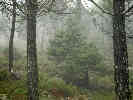 Pinsapo (Abies pinsapo Boiss.) in the Sierra Bermeja Pinsapo (Abies pinsapo Boiss.) in the Sierra Bermeja
|
The question would be, though, whether the Pinsapo is found on Los Reales because of the peridotite of which the mountain range is composed. That would make an interesting comparison to Cuesta Ridge because of the large stand of Sargent Cypress (Cupressus sargentii), also a very unusual tree, that occurs there: in poor soil from mantle rocks, on a mountain top, near an ocean or sea. | |||||||||||||||||||||||||||||||||||||||||||||||||||||||||||||||||||||||||||||||||||||||||||||||||||||||||||||||||||||||||||||||||||||||||||||||||||||||||||||||||||||||||||||||||||||||||||||||||||||||||||||||||||||||||||||||||||||||||||||||||||||||||||||||||||||||||||||||||||||||||||||||||||||||||||||||||||||||||||||||||||||||||||||||||||||||||||||||||||||||||||||||||||||||||||||||||||||||||||||||||||||||||||||||||||||||||||||||||||||||||||||||||||||||||||||||||||||||||||||||||||||||||||||||||||||||||||||||||||||||||||||||||||||||||||||||||||||||||||||||||||||||||||||||||||||||||||||||||||||||||||||||||||||||||||||||||||||||||||||||||||||||||||||
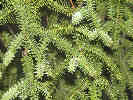 Close-up of needles on Pinsapo. Close-up of needles on Pinsapo.
|
The comparison may or may not break down because the Pinsapo also grows in Parque Nacional de Grazalema. Here the host rocks are limestones and the soil is a base rather than acid, though high in calcium and low in iron and magnesium. On the other hand, potassium and phosphorus may be depleted, even though the pH will be at the other end of the pH scale. I dont have any information about the geology of Parque Nacional de los Nieves. | |||||||||||||||||||||||||||||||||||||||||||||||||||||||||||||||||||||||||||||||||||||||||||||||||||||||||||||||||||||||||||||||||||||||||||||||||||||||||||||||||||||||||||||||||||||||||||||||||||||||||||||||||||||||||||||||||||||||||||||||||||||||||||||||||||||||||||||||||||||||||||||||||||||||||||||||||||||||||||||||||||||||||||||||||||||||||||||||||||||||||||||||||||||||||||||||||||||||||||||||||||||||||||||||||||||||||||||||||||||||||||||||||||||||||||||||||||||||||||||||||||||||||||||||||||||||||||||||||||||||||||||||||||||||||||||||||||||||||||||||||||||||||||||||||||||||||||||||||||||||||||||||||||||||||||||||||||||||||||||||||||||||||||||
|
Locations:
Puerto de Peñas Blancas.
|
At the pass called Puerto de Peñas Blancas we could see under the clouds to Estepona and the Mediterranean. | |||||||||||||||||||||||||||||||||||||||||||||||||||||||||||||||||||||||||||||||||||||||||||||||||||||||||||||||||||||||||||||||||||||||||||||||||||||||||||||||||||||||||||||||||||||||||||||||||||||||||||||||||||||||||||||||||||||||||||||||||||||||||||||||||||||||||||||||||||||||||||||||||||||||||||||||||||||||||||||||||||||||||||||||||||||||||||||||||||||||||||||||||||||||||||||||||||||||||||||||||||||||||||||||||||||||||||||||||||||||||||||||||||||||||||||||||||||||||||||||||||||||||||||||||||||||||||||||||||||||||||||||||||||||||||||||||||||||||||||||||||||||||||||||||||||||||||||||||||||||||||||||||||||||||||||||||||||||||||||||||||||||||||||
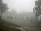 Refugio Agustin Lozano Refugio Agustin Lozano
|
The sign at the pass indicated a refugio 4.5 km down the little road into the park. We drove in and found refugio with the bathrooms unlocked. When we opened the door to the refugio, we were surprised to find someone inside with a fire going in the fireplace. They were two caretakers who said the almost did come and open the refugio because the weather was so bad. We had a cafe con leche, except Rachel who had a hot chocolate. | |||||||||||||||||||||||||||||||||||||||||||||||||||||||||||||||||||||||||||||||||||||||||||||||||||||||||||||||||||||||||||||||||||||||||||||||||||||||||||||||||||||||||||||||||||||||||||||||||||||||||||||||||||||||||||||||||||||||||||||||||||||||||||||||||||||||||||||||||||||||||||||||||||||||||||||||||||||||||||||||||||||||||||||||||||||||||||||||||||||||||||||||||||||||||||||||||||||||||||||||||||||||||||||||||||||||||||||||||||||||||||||||||||||||||||||||||||||||||||||||||||||||||||||||||||||||||||||||||||||||||||||||||||||||||||||||||||||||||||||||||||||||||||||||||||||||||||||||||||||||||||||||||||||||||||||||||||||||||||||||||||||||||||||
| Afterwards Nacho read the sign outside learning that the Pinsapo pine is a small tree, somewhat Christmas tree-like, which contributes to its poaching from the parks. | ||||||||||||||||||||||||||||||||||||||||||||||||||||||||||||||||||||||||||||||||||||||||||||||||||||||||||||||||||||||||||||||||||||||||||||||||||||||||||||||||||||||||||||||||||||||||||||||||||||||||||||||||||||||||||||||||||||||||||||||||||||||||||||||||||||||||||||||||||||||||||||||||||||||||||||||||||||||||||||||||||||||||||||||||||||||||||||||||||||||||||||||||||||||||||||||||||||||||||||||||||||||||||||||||||||||||||||||||||||||||||||||||||||||||||||||||||||||||||||||||||||||||||||||||||||||||||||||||||||||||||||||||||||||||||||||||||||||||||||||||||||||||||||||||||||||||||||||||||||||||||||||||||||||||||||||||||||||||||||||||||||||||||||||
| We found some small trees that looked like a short-needled fir. I took a couple of photos and we left in the wind and the rain. | ||||||||||||||||||||||||||||||||||||||||||||||||||||||||||||||||||||||||||||||||||||||||||||||||||||||||||||||||||||||||||||||||||||||||||||||||||||||||||||||||||||||||||||||||||||||||||||||||||||||||||||||||||||||||||||||||||||||||||||||||||||||||||||||||||||||||||||||||||||||||||||||||||||||||||||||||||||||||||||||||||||||||||||||||||||||||||||||||||||||||||||||||||||||||||||||||||||||||||||||||||||||||||||||||||||||||||||||||||||||||||||||||||||||||||||||||||||||||||||||||||||||||||||||||||||||||||||||||||||||||||||||||||||||||||||||||||||||||||||||||||||||||||||||||||||||||||||||||||||||||||||||||||||||||||||||||||||||||||||||||||||||||||||||
| Back at Puerto de Peñas Blancas, the consensus was that a return to Jubrique would be quite premature, as there is truly nothing to do there. So we turned the other way, down the hill into Estepona. It is mostly a Mediterranean resort city and held no fascination for us. | ||||||||||||||||||||||||||||||||||||||||||||||||||||||||||||||||||||||||||||||||||||||||||||||||||||||||||||||||||||||||||||||||||||||||||||||||||||||||||||||||||||||||||||||||||||||||||||||||||||||||||||||||||||||||||||||||||||||||||||||||||||||||||||||||||||||||||||||||||||||||||||||||||||||||||||||||||||||||||||||||||||||||||||||||||||||||||||||||||||||||||||||||||||||||||||||||||||||||||||||||||||||||||||||||||||||||||||||||||||||||||||||||||||||||||||||||||||||||||||||||||||||||||||||||||||||||||||||||||||||||||||||||||||||||||||||||||||||||||||||||||||||||||||||||||||||||||||||||||||||||||||||||||||||||||||||||||||||||||||||||||||||||||||||
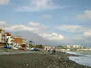 The beach at San Luis de Sabinillas with the Sierra Bermeja in the background. The beach at San Luis de Sabinillas with the Sierra Bermeja in the background.
|
Down the coast to the southwest, we stopped in a little town called San Luis de Sabinillas. There were a few restaurants open on the beach, and we picked one that had seafood. | |||||||||||||||||||||||||||||||||||||||||||||||||||||||||||||||||||||||||||||||||||||||||||||||||||||||||||||||||||||||||||||||||||||||||||||||||||||||||||||||||||||||||||||||||||||||||||||||||||||||||||||||||||||||||||||||||||||||||||||||||||||||||||||||||||||||||||||||||||||||||||||||||||||||||||||||||||||||||||||||||||||||||||||||||||||||||||||||||||||||||||||||||||||||||||||||||||||||||||||||||||||||||||||||||||||||||||||||||||||||||||||||||||||||||||||||||||||||||||||||||||||||||||||||||||||||||||||||||||||||||||||||||||||||||||||||||||||||||||||||||||||||||||||||||||||||||||||||||||||||||||||||||||||||||||||||||||||||||||||||||||||||||||||
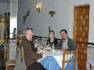 Lunch at the Seafood Restaurant Lunch at the Seafood Restaurant
|
We all started with Ensalada mixta: lettuce, onion, julienne carrots and beets, cord, tomato, a little tuna, and olives. Then I had prawns (gambas). I was expecting maybe 6 or 8 like we get in the States, but the plate had 16 gambas. Rachel had "lenguado: that we think was Dover Sole, grilled with garlic. Nacho had "sepia" or cuttlefish. Cheryl had hake, called "merluza" in Spain, breaded and deep-fried. The hake is very good, but very mild and sometimes needs a little more flavor. When we had merluza in Santiago, they used a bit of paprika for flavor. | |||||||||||||||||||||||||||||||||||||||||||||||||||||||||||||||||||||||||||||||||||||||||||||||||||||||||||||||||||||||||||||||||||||||||||||||||||||||||||||||||||||||||||||||||||||||||||||||||||||||||||||||||||||||||||||||||||||||||||||||||||||||||||||||||||||||||||||||||||||||||||||||||||||||||||||||||||||||||||||||||||||||||||||||||||||||||||||||||||||||||||||||||||||||||||||||||||||||||||||||||||||||||||||||||||||||||||||||||||||||||||||||||||||||||||||||||||||||||||||||||||||||||||||||||||||||||||||||||||||||||||||||||||||||||||||||||||||||||||||||||||||||||||||||||||||||||||||||||||||||||||||||||||||||||||||||||||||||||||||||||||||||||||||
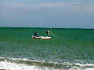 Fishermen placing their nets. Fishermen placing their nets.
|
While we ate we watched the fishermen launch their small boats and set their nets before coming back to shore. They run the keel of the boats up on boards to pull them across the sand. What we didn't learn is how long they leave the nets before they are pulled back in. | |||||||||||||||||||||||||||||||||||||||||||||||||||||||||||||||||||||||||||||||||||||||||||||||||||||||||||||||||||||||||||||||||||||||||||||||||||||||||||||||||||||||||||||||||||||||||||||||||||||||||||||||||||||||||||||||||||||||||||||||||||||||||||||||||||||||||||||||||||||||||||||||||||||||||||||||||||||||||||||||||||||||||||||||||||||||||||||||||||||||||||||||||||||||||||||||||||||||||||||||||||||||||||||||||||||||||||||||||||||||||||||||||||||||||||||||||||||||||||||||||||||||||||||||||||||||||||||||||||||||||||||||||||||||||||||||||||||||||||||||||||||||||||||||||||||||||||||||||||||||||||||||||||||||||||||||||||||||||||||||||||||||||||||
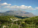 View of the Sierra Bermeja from the A-377 between San Luis de Sabinillas and Casares. View of the Sierra Bermeja from the A-377 between San Luis de Sabinillas and Casares.
|
Taking a short walk on the beach, we could look back and see that the clouds had cleared over Los Reales. So we were there just a few hours too early for the storm to clear. Looking at the Sierra Bermeja, we could also see how they got their name, "Brown Mountains," because the peridotite of which they are made weathers to a light brown. | |||||||||||||||||||||||||||||||||||||||||||||||||||||||||||||||||||||||||||||||||||||||||||||||||||||||||||||||||||||||||||||||||||||||||||||||||||||||||||||||||||||||||||||||||||||||||||||||||||||||||||||||||||||||||||||||||||||||||||||||||||||||||||||||||||||||||||||||||||||||||||||||||||||||||||||||||||||||||||||||||||||||||||||||||||||||||||||||||||||||||||||||||||||||||||||||||||||||||||||||||||||||||||||||||||||||||||||||||||||||||||||||||||||||||||||||||||||||||||||||||||||||||||||||||||||||||||||||||||||||||||||||||||||||||||||||||||||||||||||||||||||||||||||||||||||||||||||||||||||||||||||||||||||||||||||||||||||||||||||||||||||||||||||
| Cheryl found some nice shells on the beach, and I found some pebbles of peridotite. | ||||||||||||||||||||||||||||||||||||||||||||||||||||||||||||||||||||||||||||||||||||||||||||||||||||||||||||||||||||||||||||||||||||||||||||||||||||||||||||||||||||||||||||||||||||||||||||||||||||||||||||||||||||||||||||||||||||||||||||||||||||||||||||||||||||||||||||||||||||||||||||||||||||||||||||||||||||||||||||||||||||||||||||||||||||||||||||||||||||||||||||||||||||||||||||||||||||||||||||||||||||||||||||||||||||||||||||||||||||||||||||||||||||||||||||||||||||||||||||||||||||||||||||||||||||||||||||||||||||||||||||||||||||||||||||||||||||||||||||||||||||||||||||||||||||||||||||||||||||||||||||||||||||||||||||||||||||||||||||||||||||||||||||||
|
Literature Cited:
Locations:
Casares.
|
The highway to Gaucin from San Luis de Sabinillas, A-377, passes within a few kilometers west of Casares. I had read in Travel-Spain newsgroup (http://www.gomadrid.com/travelspain-faq.html) that Casares was a very nice place to visit and stay. I did not realize that Casares was so close to the Mediterranean. | |||||||||||||||||||||||||||||||||||||||||||||||||||||||||||||||||||||||||||||||||||||||||||||||||||||||||||||||||||||||||||||||||||||||||||||||||||||||||||||||||||||||||||||||||||||||||||||||||||||||||||||||||||||||||||||||||||||||||||||||||||||||||||||||||||||||||||||||||||||||||||||||||||||||||||||||||||||||||||||||||||||||||||||||||||||||||||||||||||||||||||||||||||||||||||||||||||||||||||||||||||||||||||||||||||||||||||||||||||||||||||||||||||||||||||||||||||||||||||||||||||||||||||||||||||||||||||||||||||||||||||||||||||||||||||||||||||||||||||||||||||||||||||||||||||||||||||||||||||||||||||||||||||||||||||||||||||||||||||||||||||||||||||||
|
Locations:
Gaucin.
|
After passing by Casares, the next town in view was Gaucin across the Rio Genal. Down again on the highway, across the river, and then back up the other side to Gaucin perched on the ridge. We stopped at a market for some food for snacks and tomorrow's breakfast. Then we drove thru the narrow streets looking for sights to see, a mistake! Back at the highway, we turned north on A 369, riding the ridge between the Rio Genal on the east, and Rio Guadiaro on the west, to Algatocin. | |||||||||||||||||||||||||||||||||||||||||||||||||||||||||||||||||||||||||||||||||||||||||||||||||||||||||||||||||||||||||||||||||||||||||||||||||||||||||||||||||||||||||||||||||||||||||||||||||||||||||||||||||||||||||||||||||||||||||||||||||||||||||||||||||||||||||||||||||||||||||||||||||||||||||||||||||||||||||||||||||||||||||||||||||||||||||||||||||||||||||||||||||||||||||||||||||||||||||||||||||||||||||||||||||||||||||||||||||||||||||||||||||||||||||||||||||||||||||||||||||||||||||||||||||||||||||||||||||||||||||||||||||||||||||||||||||||||||||||||||||||||||||||||||||||||||||||||||||||||||||||||||||||||||||||||||||||||||||||||||||||||||||||||
|
Locations:
Jubrique.
|
The drive up the ridge to Algatocin affording some nice views of Jubrique, Genalguacil, and the Sierra Bermeja. At Algatocin, we turned off A 369, on our road that descended to the Rio Genal and then climbed back up the ridge to Jubrique. | |||||||||||||||||||||||||||||||||||||||||||||||||||||||||||||||||||||||||||||||||||||||||||||||||||||||||||||||||||||||||||||||||||||||||||||||||||||||||||||||||||||||||||||||||||||||||||||||||||||||||||||||||||||||||||||||||||||||||||||||||||||||||||||||||||||||||||||||||||||||||||||||||||||||||||||||||||||||||||||||||||||||||||||||||||||||||||||||||||||||||||||||||||||||||||||||||||||||||||||||||||||||||||||||||||||||||||||||||||||||||||||||||||||||||||||||||||||||||||||||||||||||||||||||||||||||||||||||||||||||||||||||||||||||||||||||||||||||||||||||||||||||||||||||||||||||||||||||||||||||||||||||||||||||||||||||||||||||||||||||||||||||||||||
|
|
Sunday February 22nd. | |||||||||||||||||||||||||||||||||||||||||||||||||||||||||||||||||||||||||||||||||||||||||||||||||||||||||||||||||||||||||||||||||||||||||||||||||||||||||||||||||||||||||||||||||||||||||||||||||||||||||||||||||||||||||||||||||||||||||||||||||||||||||||||||||||||||||||||||||||||||||||||||||||||||||||||||||||||||||||||||||||||||||||||||||||||||||||||||||||||||||||||||||||||||||||||||||||||||||||||||||||||||||||||||||||||||||||||||||||||||||||||||||||||||||||||||||||||||||||||||||||||||||||||||||||||||||||||||||||||||||||||||||||||||||||||||||||||||||||||||||||||||||||||||||||||||||||||||||||||||||||||||||||||||||||||||||||||||||||||||||||||||||||||
|
Locations:
Jubrique.
|
This morning we left Jubrique after breakfast, and drove to Jimera de Libar, where Chris and Sue have their finca or small ranch. | |||||||||||||||||||||||||||||||||||||||||||||||||||||||||||||||||||||||||||||||||||||||||||||||||||||||||||||||||||||||||||||||||||||||||||||||||||||||||||||||||||||||||||||||||||||||||||||||||||||||||||||||||||||||||||||||||||||||||||||||||||||||||||||||||||||||||||||||||||||||||||||||||||||||||||||||||||||||||||||||||||||||||||||||||||||||||||||||||||||||||||||||||||||||||||||||||||||||||||||||||||||||||||||||||||||||||||||||||||||||||||||||||||||||||||||||||||||||||||||||||||||||||||||||||||||||||||||||||||||||||||||||||||||||||||||||||||||||||||||||||||||||||||||||||||||||||||||||||||||||||||||||||||||||||||||||||||||||||||||||||||||||||||||
|
Locations:
Jubrique.
|
The road from Jubrique to Algatocin descends to the Rio Genal. As the road begins its climb to Algatocin, we found Cork Oaks (Quercus suber), from which the cork had been removed recently. There was also a yard where the cork was apparently stored before processing. | |||||||||||||||||||||||||||||||||||||||||||||||||||||||||||||||||||||||||||||||||||||||||||||||||||||||||||||||||||||||||||||||||||||||||||||||||||||||||||||||||||||||||||||||||||||||||||||||||||||||||||||||||||||||||||||||||||||||||||||||||||||||||||||||||||||||||||||||||||||||||||||||||||||||||||||||||||||||||||||||||||||||||||||||||||||||||||||||||||||||||||||||||||||||||||||||||||||||||||||||||||||||||||||||||||||||||||||||||||||||||||||||||||||||||||||||||||||||||||||||||||||||||||||||||||||||||||||||||||||||||||||||||||||||||||||||||||||||||||||||||||||||||||||||||||||||||||||||||||||||||||||||||||||||||||||||||||||||||||||||||||||||||||||
|
Locations:
Jimera de Libar.
|
The plan was to meet Chris and Sue at the fountain near the entrance to Jimera. Adjacent to the fountain was a small building with a trough of water inside. I believe this building was a place to wash clothes. While we were waiting, two men drove a small flock of sheep up the main road, through the edge of town, and then up into the hills to graze. | |||||||||||||||||||||||||||||||||||||||||||||||||||||||||||||||||||||||||||||||||||||||||||||||||||||||||||||||||||||||||||||||||||||||||||||||||||||||||||||||||||||||||||||||||||||||||||||||||||||||||||||||||||||||||||||||||||||||||||||||||||||||||||||||||||||||||||||||||||||||||||||||||||||||||||||||||||||||||||||||||||||||||||||||||||||||||||||||||||||||||||||||||||||||||||||||||||||||||||||||||||||||||||||||||||||||||||||||||||||||||||||||||||||||||||||||||||||||||||||||||||||||||||||||||||||||||||||||||||||||||||||||||||||||||||||||||||||||||||||||||||||||||||||||||||||||||||||||||||||||||||||||||||||||||||||||||||||||||||||||||||||||||||||
| When Chris and Sue arrived we had introductions all around, and then walked to the finca. | ||||||||||||||||||||||||||||||||||||||||||||||||||||||||||||||||||||||||||||||||||||||||||||||||||||||||||||||||||||||||||||||||||||||||||||||||||||||||||||||||||||||||||||||||||||||||||||||||||||||||||||||||||||||||||||||||||||||||||||||||||||||||||||||||||||||||||||||||||||||||||||||||||||||||||||||||||||||||||||||||||||||||||||||||||||||||||||||||||||||||||||||||||||||||||||||||||||||||||||||||||||||||||||||||||||||||||||||||||||||||||||||||||||||||||||||||||||||||||||||||||||||||||||||||||||||||||||||||||||||||||||||||||||||||||||||||||||||||||||||||||||||||||||||||||||||||||||||||||||||||||||||||||||||||||||||||||||||||||||||||||||||||||||||
|
Locations:
Jimera de Libar.
|
From the base of the town we walked up the highway, away from town, to a small path that then led to the access road to the finca. The road stayed on the contour of the hill as we walked a short way to the ranch. The lot is about 9000 m2. When Chris and Sue bought this was about the minimal size parcel to build a house. Since then the area has been up-zoned to a minimum lot size of 25,000 m2. | |||||||||||||||||||||||||||||||||||||||||||||||||||||||||||||||||||||||||||||||||||||||||||||||||||||||||||||||||||||||||||||||||||||||||||||||||||||||||||||||||||||||||||||||||||||||||||||||||||||||||||||||||||||||||||||||||||||||||||||||||||||||||||||||||||||||||||||||||||||||||||||||||||||||||||||||||||||||||||||||||||||||||||||||||||||||||||||||||||||||||||||||||||||||||||||||||||||||||||||||||||||||||||||||||||||||||||||||||||||||||||||||||||||||||||||||||||||||||||||||||||||||||||||||||||||||||||||||||||||||||||||||||||||||||||||||||||||||||||||||||||||||||||||||||||||||||||||||||||||||||||||||||||||||||||||||||||||||||||||||||||||||||||||
|
Locations:
Jimera de Libar.
|
The basic structure of the house is finished and now the house is ready for tiling, windows, etc. As the house is built on a slope down from the access road, the main floor is the upper, with kitchen, living room, and terrace above. Below are the bedrooms. | |||||||||||||||||||||||||||||||||||||||||||||||||||||||||||||||||||||||||||||||||||||||||||||||||||||||||||||||||||||||||||||||||||||||||||||||||||||||||||||||||||||||||||||||||||||||||||||||||||||||||||||||||||||||||||||||||||||||||||||||||||||||||||||||||||||||||||||||||||||||||||||||||||||||||||||||||||||||||||||||||||||||||||||||||||||||||||||||||||||||||||||||||||||||||||||||||||||||||||||||||||||||||||||||||||||||||||||||||||||||||||||||||||||||||||||||||||||||||||||||||||||||||||||||||||||||||||||||||||||||||||||||||||||||||||||||||||||||||||||||||||||||||||||||||||||||||||||||||||||||||||||||||||||||||||||||||||||||||||||||||||||||||||||
| We also walked a short way around the property, looking at Chris olive trees, the spring, and into the house itself. I looked at the rocks a bit, and they looked like an impure limestone with minor amounts of shale and some quartz veins. I would guess this is a marine shelf deposit and should have no unusual chemistry for soil development. However, the consistency of the soil approached what we would call gumbo as it stuck to our shoes in inch-think layers. | ||||||||||||||||||||||||||||||||||||||||||||||||||||||||||||||||||||||||||||||||||||||||||||||||||||||||||||||||||||||||||||||||||||||||||||||||||||||||||||||||||||||||||||||||||||||||||||||||||||||||||||||||||||||||||||||||||||||||||||||||||||||||||||||||||||||||||||||||||||||||||||||||||||||||||||||||||||||||||||||||||||||||||||||||||||||||||||||||||||||||||||||||||||||||||||||||||||||||||||||||||||||||||||||||||||||||||||||||||||||||||||||||||||||||||||||||||||||||||||||||||||||||||||||||||||||||||||||||||||||||||||||||||||||||||||||||||||||||||||||||||||||||||||||||||||||||||||||||||||||||||||||||||||||||||||||||||||||||||||||||||||||||||||||
| The neighbors all seem to keep the soil beneath the olive trees plowed, which I would think would lead to soil depletion. I wondered whether planting of legumes such as alfalfa or clover under the olives might be a good idea. On the other hand, Chris was relating that much of the clean-up was related to discouraging pests, especially the olive fly. Many of the trees have former water bottles hanging from them. A small hole is made in the bottle, just the exact size of the olive fly, and phosphate water several inches deep is added to the bottle. Apparently, the olive trees are also sprayed from the air. If one does not want their fields sprayed to retain organic status, it is necessary to plant red flags at the corners of ones property. | ||||||||||||||||||||||||||||||||||||||||||||||||||||||||||||||||||||||||||||||||||||||||||||||||||||||||||||||||||||||||||||||||||||||||||||||||||||||||||||||||||||||||||||||||||||||||||||||||||||||||||||||||||||||||||||||||||||||||||||||||||||||||||||||||||||||||||||||||||||||||||||||||||||||||||||||||||||||||||||||||||||||||||||||||||||||||||||||||||||||||||||||||||||||||||||||||||||||||||||||||||||||||||||||||||||||||||||||||||||||||||||||||||||||||||||||||||||||||||||||||||||||||||||||||||||||||||||||||||||||||||||||||||||||||||||||||||||||||||||||||||||||||||||||||||||||||||||||||||||||||||||||||||||||||||||||||||||||||||||||||||||||||||||||
| Under one of the olive trees I found a small orchid. This was a bit of a surprise, as I would have thought such plants extirpated by the twice-yearly plowing. | ||||||||||||||||||||||||||||||||||||||||||||||||||||||||||||||||||||||||||||||||||||||||||||||||||||||||||||||||||||||||||||||||||||||||||||||||||||||||||||||||||||||||||||||||||||||||||||||||||||||||||||||||||||||||||||||||||||||||||||||||||||||||||||||||||||||||||||||||||||||||||||||||||||||||||||||||||||||||||||||||||||||||||||||||||||||||||||||||||||||||||||||||||||||||||||||||||||||||||||||||||||||||||||||||||||||||||||||||||||||||||||||||||||||||||||||||||||||||||||||||||||||||||||||||||||||||||||||||||||||||||||||||||||||||||||||||||||||||||||||||||||||||||||||||||||||||||||||||||||||||||||||||||||||||||||||||||||||||||||||||||||||||||||||
| Chris and Sue are interested in becoming an organic farm, and selling their olives as organic. They also would like to receive their own oil back from the mill, as opposed to receiving their share of olives pressed in common. At the time the nearest organic press is in Ubrique, quite a bit farther that Ronda, where last years olive crop was taken. | ||||||||||||||||||||||||||||||||||||||||||||||||||||||||||||||||||||||||||||||||||||||||||||||||||||||||||||||||||||||||||||||||||||||||||||||||||||||||||||||||||||||||||||||||||||||||||||||||||||||||||||||||||||||||||||||||||||||||||||||||||||||||||||||||||||||||||||||||||||||||||||||||||||||||||||||||||||||||||||||||||||||||||||||||||||||||||||||||||||||||||||||||||||||||||||||||||||||||||||||||||||||||||||||||||||||||||||||||||||||||||||||||||||||||||||||||||||||||||||||||||||||||||||||||||||||||||||||||||||||||||||||||||||||||||||||||||||||||||||||||||||||||||||||||||||||||||||||||||||||||||||||||||||||||||||||||||||||||||||||||||||||||||||||
| We joined Chris and Sue at their rented house in Jimera for a spot of tea and a sampling of the olives they grow on their land, and then left for Sevilla. It was a fairly easy drive from Jimera to Sevilla. The road was a bit narrow, and the going slow, in the area of Montejaque. South of Utrera we drove for a few minutes through a downpour, like the unstable air we sometimes have in the Bay Area. | ||||||||||||||||||||||||||||||||||||||||||||||||||||||||||||||||||||||||||||||||||||||||||||||||||||||||||||||||||||||||||||||||||||||||||||||||||||||||||||||||||||||||||||||||||||||||||||||||||||||||||||||||||||||||||||||||||||||||||||||||||||||||||||||||||||||||||||||||||||||||||||||||||||||||||||||||||||||||||||||||||||||||||||||||||||||||||||||||||||||||||||||||||||||||||||||||||||||||||||||||||||||||||||||||||||||||||||||||||||||||||||||||||||||||||||||||||||||||||||||||||||||||||||||||||||||||||||||||||||||||||||||||||||||||||||||||||||||||||||||||||||||||||||||||||||||||||||||||||||||||||||||||||||||||||||||||||||||||||||||||||||||||||||||
|
|
Monday, February 23rd. | |||||||||||||||||||||||||||||||||||||||||||||||||||||||||||||||||||||||||||||||||||||||||||||||||||||||||||||||||||||||||||||||||||||||||||||||||||||||||||||||||||||||||||||||||||||||||||||||||||||||||||||||||||||||||||||||||||||||||||||||||||||||||||||||||||||||||||||||||||||||||||||||||||||||||||||||||||||||||||||||||||||||||||||||||||||||||||||||||||||||||||||||||||||||||||||||||||||||||||||||||||||||||||||||||||||||||||||||||||||||||||||||||||||||||||||||||||||||||||||||||||||||||||||||||||||||||||||||||||||||||||||||||||||||||||||||||||||||||||||||||||||||||||||||||||||||||||||||||||||||||||||||||||||||||||||||||||||||||||||||||||||||||||||
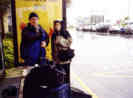 Waiting for the bus in the rain. Waiting for the bus in the rain.
|
This morning we are on the Ave from Sevilla to Madrid. We arose early, and after packing, walked in the rain to the bus stop in Bormujos. | |||||||||||||||||||||||||||||||||||||||||||||||||||||||||||||||||||||||||||||||||||||||||||||||||||||||||||||||||||||||||||||||||||||||||||||||||||||||||||||||||||||||||||||||||||||||||||||||||||||||||||||||||||||||||||||||||||||||||||||||||||||||||||||||||||||||||||||||||||||||||||||||||||||||||||||||||||||||||||||||||||||||||||||||||||||||||||||||||||||||||||||||||||||||||||||||||||||||||||||||||||||||||||||||||||||||||||||||||||||||||||||||||||||||||||||||||||||||||||||||||||||||||||||||||||||||||||||||||||||||||||||||||||||||||||||||||||||||||||||||||||||||||||||||||||||||||||||||||||||||||||||||||||||||||||||||||||||||||||||||||||||||||||||
| The Bormujos-Sevilla bus route ends at Plaza de Armas, from where we took a taxi to Estacion Santa Justa. There is no baggage check to Madrid from Sevilla, so we loaded our baggage ourselves into the maletera of the coach. | ||||||||||||||||||||||||||||||||||||||||||||||||||||||||||||||||||||||||||||||||||||||||||||||||||||||||||||||||||||||||||||||||||||||||||||||||||||||||||||||||||||||||||||||||||||||||||||||||||||||||||||||||||||||||||||||||||||||||||||||||||||||||||||||||||||||||||||||||||||||||||||||||||||||||||||||||||||||||||||||||||||||||||||||||||||||||||||||||||||||||||||||||||||||||||||||||||||||||||||||||||||||||||||||||||||||||||||||||||||||||||||||||||||||||||||||||||||||||||||||||||||||||||||||||||||||||||||||||||||||||||||||||||||||||||||||||||||||||||||||||||||||||||||||||||||||||||||||||||||||||||||||||||||||||||||||||||||||||||||||||||||||||||||||
|
|
Sunday, April 18,2004 | |||||||||||||||||||||||||||||||||||||||||||||||||||||||||||||||||||||||||||||||||||||||||||||||||||||||||||||||||||||||||||||||||||||||||||||||||||||||||||||||||||||||||||||||||||||||||||||||||||||||||||||||||||||||||||||||||||||||||||||||||||||||||||||||||||||||||||||||||||||||||||||||||||||||||||||||||||||||||||||||||||||||||||||||||||||||||||||||||||||||||||||||||||||||||||||||||||||||||||||||||||||||||||||||||||||||||||||||||||||||||||||||||||||||||||||||||||||||||||||||||||||||||||||||||||||||||||||||||||||||||||||||||||||||||||||||||||||||||||||||||||||||||||||||||||||||||||||||||||||||||||||||||||||||||||||||||||||||||||||||||||||||||||||
|
Other articles:
|
Sunday morning I left Alameda, and headed south on I-880 and US Highway 101 to the turnoff to Hollister at CA Highway 25. Passing through Hollister on CA Highway 25, I passed through Tres Piños to Paicines. This is apparently one place where the San Andreas Fault is tearing apart the foundations of a winery building. I did find this perched reservoir interesting. | |||||||||||||||||||||||||||||||||||||||||||||||||||||||||||||||||||||||||||||||||||||||||||||||||||||||||||||||||||||||||||||||||||||||||||||||||||||||||||||||||||||||||||||||||||||||||||||||||||||||||||||||||||||||||||||||||||||||||||||||||||||||||||||||||||||||||||||||||||||||||||||||||||||||||||||||||||||||||||||||||||||||||||||||||||||||||||||||||||||||||||||||||||||||||||||||||||||||||||||||||||||||||||||||||||||||||||||||||||||||||||||||||||||||||||||||||||||||||||||||||||||||||||||||||||||||||||||||||||||||||||||||||||||||||||||||||||||||||||||||||||||||||||||||||||||||||||||||||||||||||||||||||||||||||||||||||||||||||||||||||||||||||||||
|
Other articles:
|
From Paicines south the highway follows a long straight valley formed by the fault. | |||||||||||||||||||||||||||||||||||||||||||||||||||||||||||||||||||||||||||||||||||||||||||||||||||||||||||||||||||||||||||||||||||||||||||||||||||||||||||||||||||||||||||||||||||||||||||||||||||||||||||||||||||||||||||||||||||||||||||||||||||||||||||||||||||||||||||||||||||||||||||||||||||||||||||||||||||||||||||||||||||||||||||||||||||||||||||||||||||||||||||||||||||||||||||||||||||||||||||||||||||||||||||||||||||||||||||||||||||||||||||||||||||||||||||||||||||||||||||||||||||||||||||||||||||||||||||||||||||||||||||||||||||||||||||||||||||||||||||||||||||||||||||||||||||||||||||||||||||||||||||||||||||||||||||||||||||||||||||||||||||||||||||||
| The small hills and ridges in the valley are likely pressure ridges resulting from movement along the fault. | ||||||||||||||||||||||||||||||||||||||||||||||||||||||||||||||||||||||||||||||||||||||||||||||||||||||||||||||||||||||||||||||||||||||||||||||||||||||||||||||||||||||||||||||||||||||||||||||||||||||||||||||||||||||||||||||||||||||||||||||||||||||||||||||||||||||||||||||||||||||||||||||||||||||||||||||||||||||||||||||||||||||||||||||||||||||||||||||||||||||||||||||||||||||||||||||||||||||||||||||||||||||||||||||||||||||||||||||||||||||||||||||||||||||||||||||||||||||||||||||||||||||||||||||||||||||||||||||||||||||||||||||||||||||||||||||||||||||||||||||||||||||||||||||||||||||||||||||||||||||||||||||||||||||||||||||||||||||||||||||||||||||||||||||
| I stopped at Pinnacles National Monument for a little while and hiked up to the reservoir, than around the rim trail. | ||||||||||||||||||||||||||||||||||||||||||||||||||||||||||||||||||||||||||||||||||||||||||||||||||||||||||||||||||||||||||||||||||||||||||||||||||||||||||||||||||||||||||||||||||||||||||||||||||||||||||||||||||||||||||||||||||||||||||||||||||||||||||||||||||||||||||||||||||||||||||||||||||||||||||||||||||||||||||||||||||||||||||||||||||||||||||||||||||||||||||||||||||||||||||||||||||||||||||||||||||||||||||||||||||||||||||||||||||||||||||||||||||||||||||||||||||||||||||||||||||||||||||||||||||||||||||||||||||||||||||||||||||||||||||||||||||||||||||||||||||||||||||||||||||||||||||||||||||||||||||||||||||||||||||||||||||||||||||||||||||||||||||||||
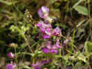 Collinisia at Pinnacles National Monument Collinisia at Pinnacles National Monument
|
In the canyons, I saw a Collinsia and a Brodeia ixiodes in bloom as well as what I think is Nemophila. | |||||||||||||||||||||||||||||||||||||||||||||||||||||||||||||||||||||||||||||||||||||||||||||||||||||||||||||||||||||||||||||||||||||||||||||||||||||||||||||||||||||||||||||||||||||||||||||||||||||||||||||||||||||||||||||||||||||||||||||||||||||||||||||||||||||||||||||||||||||||||||||||||||||||||||||||||||||||||||||||||||||||||||||||||||||||||||||||||||||||||||||||||||||||||||||||||||||||||||||||||||||||||||||||||||||||||||||||||||||||||||||||||||||||||||||||||||||||||||||||||||||||||||||||||||||||||||||||||||||||||||||||||||||||||||||||||||||||||||||||||||||||||||||||||||||||||||||||||||||||||||||||||||||||||||||||||||||||||||||||||||||||||||||
 Climbers at Pinnacles National Monument. Climbers at Pinnacles National Monument.
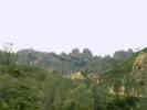 View of the Pinnacles from the canyon below. View of the Pinnacles from the canyon below.
|
Pinnacles is a popular climbing location, and nearly every climbable rock has a climber on it. | |||||||||||||||||||||||||||||||||||||||||||||||||||||||||||||||||||||||||||||||||||||||||||||||||||||||||||||||||||||||||||||||||||||||||||||||||||||||||||||||||||||||||||||||||||||||||||||||||||||||||||||||||||||||||||||||||||||||||||||||||||||||||||||||||||||||||||||||||||||||||||||||||||||||||||||||||||||||||||||||||||||||||||||||||||||||||||||||||||||||||||||||||||||||||||||||||||||||||||||||||||||||||||||||||||||||||||||||||||||||||||||||||||||||||||||||||||||||||||||||||||||||||||||||||||||||||||||||||||||||||||||||||||||||||||||||||||||||||||||||||||||||||||||||||||||||||||||||||||||||||||||||||||||||||||||||||||||||||||||||||||||||||||||
|
Other articles:
Locations:
Peachtree Valley.
|
Leaving Pinnacles, I continued south on Highway 25 through Bitterwater and then into Peach Tree Valley. | |||||||||||||||||||||||||||||||||||||||||||||||||||||||||||||||||||||||||||||||||||||||||||||||||||||||||||||||||||||||||||||||||||||||||||||||||||||||||||||||||||||||||||||||||||||||||||||||||||||||||||||||||||||||||||||||||||||||||||||||||||||||||||||||||||||||||||||||||||||||||||||||||||||||||||||||||||||||||||||||||||||||||||||||||||||||||||||||||||||||||||||||||||||||||||||||||||||||||||||||||||||||||||||||||||||||||||||||||||||||||||||||||||||||||||||||||||||||||||||||||||||||||||||||||||||||||||||||||||||||||||||||||||||||||||||||||||||||||||||||||||||||||||||||||||||||||||||||||||||||||||||||||||||||||||||||||||||||||||||||||||||||||||||
|
Other articles:
|
CA Highway 25 ends at California Highway 198, the road from King City to Coalinga. | |||||||||||||||||||||||||||||||||||||||||||||||||||||||||||||||||||||||||||||||||||||||||||||||||||||||||||||||||||||||||||||||||||||||||||||||||||||||||||||||||||||||||||||||||||||||||||||||||||||||||||||||||||||||||||||||||||||||||||||||||||||||||||||||||||||||||||||||||||||||||||||||||||||||||||||||||||||||||||||||||||||||||||||||||||||||||||||||||||||||||||||||||||||||||||||||||||||||||||||||||||||||||||||||||||||||||||||||||||||||||||||||||||||||||||||||||||||||||||||||||||||||||||||||||||||||||||||||||||||||||||||||||||||||||||||||||||||||||||||||||||||||||||||||||||||||||||||||||||||||||||||||||||||||||||||||||||||||||||||||||||||||||||||
|
Other articles:
|
However, I continued on Peach Tree Road, south until it became Indian Valley Road. | |||||||||||||||||||||||||||||||||||||||||||||||||||||||||||||||||||||||||||||||||||||||||||||||||||||||||||||||||||||||||||||||||||||||||||||||||||||||||||||||||||||||||||||||||||||||||||||||||||||||||||||||||||||||||||||||||||||||||||||||||||||||||||||||||||||||||||||||||||||||||||||||||||||||||||||||||||||||||||||||||||||||||||||||||||||||||||||||||||||||||||||||||||||||||||||||||||||||||||||||||||||||||||||||||||||||||||||||||||||||||||||||||||||||||||||||||||||||||||||||||||||||||||||||||||||||||||||||||||||||||||||||||||||||||||||||||||||||||||||||||||||||||||||||||||||||||||||||||||||||||||||||||||||||||||||||||||||||||||||||||||||||||||||
|
Other articles:
|
Here the painted yellow fish hanging in the Oak tree surprised me. I presume a local rancher is also a fisherman, and has hung this whimsical fish in the tree. | |||||||||||||||||||||||||||||||||||||||||||||||||||||||||||||||||||||||||||||||||||||||||||||||||||||||||||||||||||||||||||||||||||||||||||||||||||||||||||||||||||||||||||||||||||||||||||||||||||||||||||||||||||||||||||||||||||||||||||||||||||||||||||||||||||||||||||||||||||||||||||||||||||||||||||||||||||||||||||||||||||||||||||||||||||||||||||||||||||||||||||||||||||||||||||||||||||||||||||||||||||||||||||||||||||||||||||||||||||||||||||||||||||||||||||||||||||||||||||||||||||||||||||||||||||||||||||||||||||||||||||||||||||||||||||||||||||||||||||||||||||||||||||||||||||||||||||||||||||||||||||||||||||||||||||||||||||||||||||||||||||||||||||||
|
Other articles:
|
This photo of lower Indian Valley shows the stream bed far exceeds the capacity of the stream, and that the hills are already starting to turn brown. | |||||||||||||||||||||||||||||||||||||||||||||||||||||||||||||||||||||||||||||||||||||||||||||||||||||||||||||||||||||||||||||||||||||||||||||||||||||||||||||||||||||||||||||||||||||||||||||||||||||||||||||||||||||||||||||||||||||||||||||||||||||||||||||||||||||||||||||||||||||||||||||||||||||||||||||||||||||||||||||||||||||||||||||||||||||||||||||||||||||||||||||||||||||||||||||||||||||||||||||||||||||||||||||||||||||||||||||||||||||||||||||||||||||||||||||||||||||||||||||||||||||||||||||||||||||||||||||||||||||||||||||||||||||||||||||||||||||||||||||||||||||||||||||||||||||||||||||||||||||||||||||||||||||||||||||||||||||||||||||||||||||||||||||
| Indian Valley road ends at San Miguel, where I entered US Highway 101 and traveled on to Atascadero. | ||||||||||||||||||||||||||||||||||||||||||||||||||||||||||||||||||||||||||||||||||||||||||||||||||||||||||||||||||||||||||||||||||||||||||||||||||||||||||||||||||||||||||||||||||||||||||||||||||||||||||||||||||||||||||||||||||||||||||||||||||||||||||||||||||||||||||||||||||||||||||||||||||||||||||||||||||||||||||||||||||||||||||||||||||||||||||||||||||||||||||||||||||||||||||||||||||||||||||||||||||||||||||||||||||||||||||||||||||||||||||||||||||||||||||||||||||||||||||||||||||||||||||||||||||||||||||||||||||||||||||||||||||||||||||||||||||||||||||||||||||||||||||||||||||||||||||||||||||||||||||||||||||||||||||||||||||||||||||||||||||||||||||||||
|
|
Monday, April 19,2004 | |||||||||||||||||||||||||||||||||||||||||||||||||||||||||||||||||||||||||||||||||||||||||||||||||||||||||||||||||||||||||||||||||||||||||||||||||||||||||||||||||||||||||||||||||||||||||||||||||||||||||||||||||||||||||||||||||||||||||||||||||||||||||||||||||||||||||||||||||||||||||||||||||||||||||||||||||||||||||||||||||||||||||||||||||||||||||||||||||||||||||||||||||||||||||||||||||||||||||||||||||||||||||||||||||||||||||||||||||||||||||||||||||||||||||||||||||||||||||||||||||||||||||||||||||||||||||||||||||||||||||||||||||||||||||||||||||||||||||||||||||||||||||||||||||||||||||||||||||||||||||||||||||||||||||||||||||||||||||||||||||||||||||||||
| On Monday morning, I left Atascadero fairly early, diving north on US Highway 101 and then east on CA Highway 46. | ||||||||||||||||||||||||||||||||||||||||||||||||||||||||||||||||||||||||||||||||||||||||||||||||||||||||||||||||||||||||||||||||||||||||||||||||||||||||||||||||||||||||||||||||||||||||||||||||||||||||||||||||||||||||||||||||||||||||||||||||||||||||||||||||||||||||||||||||||||||||||||||||||||||||||||||||||||||||||||||||||||||||||||||||||||||||||||||||||||||||||||||||||||||||||||||||||||||||||||||||||||||||||||||||||||||||||||||||||||||||||||||||||||||||||||||||||||||||||||||||||||||||||||||||||||||||||||||||||||||||||||||||||||||||||||||||||||||||||||||||||||||||||||||||||||||||||||||||||||||||||||||||||||||||||||||||||||||||||||||||||||||||||||||
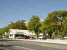 Jack Ranch Caf e and James Dean Memorial at Cholame, CA. Jack Ranch Caf e and James Dean Memorial at Cholame, CA.
|
Stopped briefly at the Jack Ranch Café in Cholame, for a photo of the café and the James Dean memorial. Here I learned that the actual crash site is a half mile east on CA Highway 46, and 200 yards to the west, in the middle of a farm field. The intersection was realigned when the highway was repaved and renumbered back in 1973. The old intersection and the last 8 miles of the highway that Dean traveled are on land belonging to the State Water Department, and The Jack Ranch, and permission must be obtained to walk or drive the short stretch of old highway. | |||||||||||||||||||||||||||||||||||||||||||||||||||||||||||||||||||||||||||||||||||||||||||||||||||||||||||||||||||||||||||||||||||||||||||||||||||||||||||||||||||||||||||||||||||||||||||||||||||||||||||||||||||||||||||||||||||||||||||||||||||||||||||||||||||||||||||||||||||||||||||||||||||||||||||||||||||||||||||||||||||||||||||||||||||||||||||||||||||||||||||||||||||||||||||||||||||||||||||||||||||||||||||||||||||||||||||||||||||||||||||||||||||||||||||||||||||||||||||||||||||||||||||||||||||||||||||||||||||||||||||||||||||||||||||||||||||||||||||||||||||||||||||||||||||||||||||||||||||||||||||||||||||||||||||||||||||||||||||||||||||||||||||||
| From Cholame, drove to I-5 then across CA Highway 58 into Bakersfield. Made a couple of stops here. One was my usual stop for gas and last minute groceries at the Albertsons. Some time this morning I realized that I had no stove. So I stopped at Walmart and bought a Coleman propane stove. | ||||||||||||||||||||||||||||||||||||||||||||||||||||||||||||||||||||||||||||||||||||||||||||||||||||||||||||||||||||||||||||||||||||||||||||||||||||||||||||||||||||||||||||||||||||||||||||||||||||||||||||||||||||||||||||||||||||||||||||||||||||||||||||||||||||||||||||||||||||||||||||||||||||||||||||||||||||||||||||||||||||||||||||||||||||||||||||||||||||||||||||||||||||||||||||||||||||||||||||||||||||||||||||||||||||||||||||||||||||||||||||||||||||||||||||||||||||||||||||||||||||||||||||||||||||||||||||||||||||||||||||||||||||||||||||||||||||||||||||||||||||||||||||||||||||||||||||||||||||||||||||||||||||||||||||||||||||||||||||||||||||||||||||||
| Moving on through Tehachapi Pass, the Highway 58 bypass of Mojave is now open. I guess it was a good thing, but driving through Mojave was a kind of break in the monotony, and now is replaced by more monotony. Stopped at the Boron rest stop for lunch. | ||||||||||||||||||||||||||||||||||||||||||||||||||||||||||||||||||||||||||||||||||||||||||||||||||||||||||||||||||||||||||||||||||||||||||||||||||||||||||||||||||||||||||||||||||||||||||||||||||||||||||||||||||||||||||||||||||||||||||||||||||||||||||||||||||||||||||||||||||||||||||||||||||||||||||||||||||||||||||||||||||||||||||||||||||||||||||||||||||||||||||||||||||||||||||||||||||||||||||||||||||||||||||||||||||||||||||||||||||||||||||||||||||||||||||||||||||||||||||||||||||||||||||||||||||||||||||||||||||||||||||||||||||||||||||||||||||||||||||||||||||||||||||||||||||||||||||||||||||||||||||||||||||||||||||||||||||||||||||||||||||||||||||||||
|
Other articles:
Locations:
Ludlow.
|
Flew right through Barstow, stopping in Ludlow for gas. Here I took the photo of the forelorn Ludlow Café, only to learn later that this is not the original Ludlow Café, which seems to be down the road a bit. | |||||||||||||||||||||||||||||||||||||||||||||||||||||||||||||||||||||||||||||||||||||||||||||||||||||||||||||||||||||||||||||||||||||||||||||||||||||||||||||||||||||||||||||||||||||||||||||||||||||||||||||||||||||||||||||||||||||||||||||||||||||||||||||||||||||||||||||||||||||||||||||||||||||||||||||||||||||||||||||||||||||||||||||||||||||||||||||||||||||||||||||||||||||||||||||||||||||||||||||||||||||||||||||||||||||||||||||||||||||||||||||||||||||||||||||||||||||||||||||||||||||||||||||||||||||||||||||||||||||||||||||||||||||||||||||||||||||||||||||||||||||||||||||||||||||||||||||||||||||||||||||||||||||||||||||||||||||||||||||||||||||||||||||
|
Other articles:
|
From Ludlow, I stayed on the old Route 66, mostly looking for the locations of Bagdad and Siberia, while watching for trains. | |||||||||||||||||||||||||||||||||||||||||||||||||||||||||||||||||||||||||||||||||||||||||||||||||||||||||||||||||||||||||||||||||||||||||||||||||||||||||||||||||||||||||||||||||||||||||||||||||||||||||||||||||||||||||||||||||||||||||||||||||||||||||||||||||||||||||||||||||||||||||||||||||||||||||||||||||||||||||||||||||||||||||||||||||||||||||||||||||||||||||||||||||||||||||||||||||||||||||||||||||||||||||||||||||||||||||||||||||||||||||||||||||||||||||||||||||||||||||||||||||||||||||||||||||||||||||||||||||||||||||||||||||||||||||||||||||||||||||||||||||||||||||||||||||||||||||||||||||||||||||||||||||||||||||||||||||||||||||||||||||||||||||||||
|
Other articles:
Locations:
Amboy.
|
In Amboy, it appeared that the café and gas station was closed at the moment, so I went on. | |||||||||||||||||||||||||||||||||||||||||||||||||||||||||||||||||||||||||||||||||||||||||||||||||||||||||||||||||||||||||||||||||||||||||||||||||||||||||||||||||||||||||||||||||||||||||||||||||||||||||||||||||||||||||||||||||||||||||||||||||||||||||||||||||||||||||||||||||||||||||||||||||||||||||||||||||||||||||||||||||||||||||||||||||||||||||||||||||||||||||||||||||||||||||||||||||||||||||||||||||||||||||||||||||||||||||||||||||||||||||||||||||||||||||||||||||||||||||||||||||||||||||||||||||||||||||||||||||||||||||||||||||||||||||||||||||||||||||||||||||||||||||||||||||||||||||||||||||||||||||||||||||||||||||||||||||||||||||||||||||||||||||||||
|
Other articles:
|
Ive had several people write to me asking about the Shoe Tree. It turns out to be a Palo Verde, festooned with shoes between Amboy and Chambless. | |||||||||||||||||||||||||||||||||||||||||||||||||||||||||||||||||||||||||||||||||||||||||||||||||||||||||||||||||||||||||||||||||||||||||||||||||||||||||||||||||||||||||||||||||||||||||||||||||||||||||||||||||||||||||||||||||||||||||||||||||||||||||||||||||||||||||||||||||||||||||||||||||||||||||||||||||||||||||||||||||||||||||||||||||||||||||||||||||||||||||||||||||||||||||||||||||||||||||||||||||||||||||||||||||||||||||||||||||||||||||||||||||||||||||||||||||||||||||||||||||||||||||||||||||||||||||||||||||||||||||||||||||||||||||||||||||||||||||||||||||||||||||||||||||||||||||||||||||||||||||||||||||||||||||||||||||||||||||||||||||||||||||||||
|
Other articles:
Locations:
Essex.
|
Looking for something photogenic in Essex was a lost cause, so I settled upon the Post Office. From Essex, I turned north up Essex Road, across US I-40 and into Mojave National Preserve, where I camped at Mid Hills Campground. | |||||||||||||||||||||||||||||||||||||||||||||||||||||||||||||||||||||||||||||||||||||||||||||||||||||||||||||||||||||||||||||||||||||||||||||||||||||||||||||||||||||||||||||||||||||||||||||||||||||||||||||||||||||||||||||||||||||||||||||||||||||||||||||||||||||||||||||||||||||||||||||||||||||||||||||||||||||||||||||||||||||||||||||||||||||||||||||||||||||||||||||||||||||||||||||||||||||||||||||||||||||||||||||||||||||||||||||||||||||||||||||||||||||||||||||||||||||||||||||||||||||||||||||||||||||||||||||||||||||||||||||||||||||||||||||||||||||||||||||||||||||||||||||||||||||||||||||||||||||||||||||||||||||||||||||||||||||||||||||||||||||||||||||
|
Other articles:
Locations:
Mid Hills Campground.
|
||||||||||||||||||||||||||||||||||||||||||||||||||||||||||||||||||||||||||||||||||||||||||||||||||||||||||||||||||||||||||||||||||||||||||||||||||||||||||||||||||||||||||||||||||||||||||||||||||||||||||||||||||||||||||||||||||||||||||||||||||||||||||||||||||||||||||||||||||||||||||||||||||||||||||||||||||||||||||||||||||||||||||||||||||||||||||||||||||||||||||||||||||||||||||||||||||||||||||||||||||||||||||||||||||||||||||||||||||||||||||||||||||||||||||||||||||||||||||||||||||||||||||||||||||||||||||||||||||||||||||||||||||||||||||||||||||||||||||||||||||||||||||||||||||||||||||||||||||||||||||||||||||||||||||||||||||||||||||||||||||||||||||||||
|
|
Tuesday, April 20, 2004 | |||||||||||||||||||||||||||||||||||||||||||||||||||||||||||||||||||||||||||||||||||||||||||||||||||||||||||||||||||||||||||||||||||||||||||||||||||||||||||||||||||||||||||||||||||||||||||||||||||||||||||||||||||||||||||||||||||||||||||||||||||||||||||||||||||||||||||||||||||||||||||||||||||||||||||||||||||||||||||||||||||||||||||||||||||||||||||||||||||||||||||||||||||||||||||||||||||||||||||||||||||||||||||||||||||||||||||||||||||||||||||||||||||||||||||||||||||||||||||||||||||||||||||||||||||||||||||||||||||||||||||||||||||||||||||||||||||||||||||||||||||||||||||||||||||||||||||||||||||||||||||||||||||||||||||||||||||||||||||||||||||||||||||||
| The junction of Kingston Road and Excelsior Road is 12.6 miles north of Valley Wells. | ||||||||||||||||||||||||||||||||||||||||||||||||||||||||||||||||||||||||||||||||||||||||||||||||||||||||||||||||||||||||||||||||||||||||||||||||||||||||||||||||||||||||||||||||||||||||||||||||||||||||||||||||||||||||||||||||||||||||||||||||||||||||||||||||||||||||||||||||||||||||||||||||||||||||||||||||||||||||||||||||||||||||||||||||||||||||||||||||||||||||||||||||||||||||||||||||||||||||||||||||||||||||||||||||||||||||||||||||||||||||||||||||||||||||||||||||||||||||||||||||||||||||||||||||||||||||||||||||||||||||||||||||||||||||||||||||||||||||||||||||||||||||||||||||||||||||||||||||||||||||||||||||||||||||||||||||||||||||||||||||||||||||||||||
| Stopped on Kingston Road at 13.0 miles north of Valley Wells, UTM 11S 0615064 3942014, at elevation 1080 meters. | ||||||||||||||||||||||||||||||||||||||||||||||||||||||||||||||||||||||||||||||||||||||||||||||||||||||||||||||||||||||||||||||||||||||||||||||||||||||||||||||||||||||||||||||||||||||||||||||||||||||||||||||||||||||||||||||||||||||||||||||||||||||||||||||||||||||||||||||||||||||||||||||||||||||||||||||||||||||||||||||||||||||||||||||||||||||||||||||||||||||||||||||||||||||||||||||||||||||||||||||||||||||||||||||||||||||||||||||||||||||||||||||||||||||||||||||||||||||||||||||||||||||||||||||||||||||||||||||||||||||||||||||||||||||||||||||||||||||||||||||||||||||||||||||||||||||||||||||||||||||||||||||||||||||||||||||||||||||||||||||||||||||||||||||
| Other plants at this location include Yucca brevifolia, Pencil Cholla, Salvia dorrii, Krameria erecta, and Ambrosia eriocentra in the wash. | ||||||||||||||||||||||||||||||||||||||||||||||||||||||||||||||||||||||||||||||||||||||||||||||||||||||||||||||||||||||||||||||||||||||||||||||||||||||||||||||||||||||||||||||||||||||||||||||||||||||||||||||||||||||||||||||||||||||||||||||||||||||||||||||||||||||||||||||||||||||||||||||||||||||||||||||||||||||||||||||||||||||||||||||||||||||||||||||||||||||||||||||||||||||||||||||||||||||||||||||||||||||||||||||||||||||||||||||||||||||||||||||||||||||||||||||||||||||||||||||||||||||||||||||||||||||||||||||||||||||||||||||||||||||||||||||||||||||||||||||||||||||||||||||||||||||||||||||||||||||||||||||||||||||||||||||||||||||||||||||||||||||||||||||
|
Other articles:
|
330 |
Shadow Valley, San Bernardino County, California. In Creosote Bush scrub, just west of the Winters Pass Hills, on Kingston Road, climbing to Winters Pass in the Mesquite Mountains. 35.6579°N, 115.7142°W. WGS 1984. Elev. 1080 m. Coll. No. 330, 20 Apr 2004, characters observed while keying: Annual, tap-rooted, to 35 cm.; Stem variously branched, proximal hairs 0, distally minutely glandular; Leaves, alternate, to 7 cm., deeply pinnately lobed below to entire above; Inflorescence, single heads on 5 cm. peduncles, flowers of two kinds in same heads, outer corollas not strap- shaped, head radiant; Phyllaries in 2+ series, ±equal length, outermost sometimes subtending a ray flower, without embedded oil gland, margin green, tip acute; Pappus of scales, few, one long (6 mm.) appearing among disc flowers remainder short, margins ragged; Corollas white; Fruit, 6 mm., dark brown. | ||||||||||||||||||||||||||||||||||||||||||||||||||||||||||||||||||||||||||||||||||||||||||||||||||||||||||||||||||||||||||||||||||||||||||||||||||||||||||||||||||||||||||||||||||||||||||||||||||||||||||||||||||||||||||||||||||||||||||||||||||||||||||||||||||||||||||||||||||||||||||||||||||||||||||||||||||||||||||||||||||||||||||||||||||||||||||||||||||||||||||||||||||||||||||||||||||||||||||||||||||||||||||||||||||||||||||||||||||||||||||||||||||||||||||||||||||||||||||||||||||||||||||||||||||||||||||||||||||||||||||||||||||||||||||||||||||||||||||||||||||||||||||||||||||||||||||||||||||||||||||||||||||||||||||||||||||||||||||||||||||||||||||||
 Rafinesquia neomexicana near the Mesquite Mountains Rafinesquia neomexicana near the Mesquite Mountains
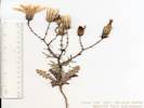 Coll. No. 331, Rafinesquia neomexicana Coll. No. 331, Rafinesquia neomexicana
|
331 |
Rafinesquia californica Nutt. California Chicory.
Shadow Valley, San Bernardino County, California. In Creosote Bush scrub, on Kingston Road about 0.4 mi north of the intersection with Excelsior Mine Road, climbing to Winters Pass in the Mesquite Mountains. 35.6578°N, 115.7141°W. WGS 1984. Elev. 1080 m. Coll. No. 331, 20 Apr 2004, characters observed while keying: Annual; Leaves lower deeply lobed; Head all strap-shaped flowers; Receptacle epaleate; Ligules white, 5-lobed, > phyllaries by 10 mm.; Pappus of plumose bristles, not scale-like, ± equal; Fruit 8 mm., + 5 mm. beak, i.e., beak < body (I thought the beak was slender, but maybe it's comparatively stout). | ||||||||||||||||||||||||||||||||||||||||||||||||||||||||||||||||||||||||||||||||||||||||||||||||||||||||||||||||||||||||||||||||||||||||||||||||||||||||||||||||||||||||||||||||||||||||||||||||||||||||||||||||||||||||||||||||||||||||||||||||||||||||||||||||||||||||||||||||||||||||||||||||||||||||||||||||||||||||||||||||||||||||||||||||||||||||||||||||||||||||||||||||||||||||||||||||||||||||||||||||||||||||||||||||||||||||||||||||||||||||||||||||||||||||||||||||||||||||||||||||||||||||||||||||||||||||||||||||||||||||||||||||||||||||||||||||||||||||||||||||||||||||||||||||||||||||||||||||||||||||||||||||||||||||||||||||||||||||||||||||||||||||||||
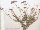 Coll. No. 322, Eriogonum fasciculatum var. polifolium Coll. No. 322, Eriogonum fasciculatum var. polifolium
|
332 |
Eriogonum fasciculatum Benth. ssp. polifolium (A. DC.) Torrey & A. Gray. California Buckwheat.
Shadow Valley, San Bernardino County, California. In Creosote Bush scrub, on Kingston Road about 0.4 mi north of the intersection with Excelsior Mine Road, climbing to Winters Pass in the Mesquite Mountains. 35.6578°N, 115.7141°W. WGS 1984. Elev. 1080 m. Coll. No. 332, 20 Apr 2004, characters observed while keying: Perennial shrub; Stem not jointed; Leaves narrowly oblanceolate, 10-15 mm., adaxially lightly tomentose, abaxially tomentose, margins rolled under; Inflorescence umbel-like; Involucres > 1 per node, hairy; Flower stipe absent; Perianth lobes alike, white to pink, soft hairy. | ||||||||||||||||||||||||||||||||||||||||||||||||||||||||||||||||||||||||||||||||||||||||||||||||||||||||||||||||||||||||||||||||||||||||||||||||||||||||||||||||||||||||||||||||||||||||||||||||||||||||||||||||||||||||||||||||||||||||||||||||||||||||||||||||||||||||||||||||||||||||||||||||||||||||||||||||||||||||||||||||||||||||||||||||||||||||||||||||||||||||||||||||||||||||||||||||||||||||||||||||||||||||||||||||||||||||||||||||||||||||||||||||||||||||||||||||||||||||||||||||||||||||||||||||||||||||||||||||||||||||||||||||||||||||||||||||||||||||||||||||||||||||||||||||||||||||||||||||||||||||||||||||||||||||||||||||||||||||||||||||||||||||||||
|
Literature Cited:
Other articles:
|
333 | Hymenoclea salsola = Ambrosia salsola (A. Gray) Strother & B. G. Baldwin | ||||||||||||||||||||||||||||||||||||||||||||||||||||||||||||||||||||||||||||||||||||||||||||||||||||||||||||||||||||||||||||||||||||||||||||||||||||||||||||||||||||||||||||||||||||||||||||||||||||||||||||||||||||||||||||||||||||||||||||||||||||||||||||||||||||||||||||||||||||||||||||||||||||||||||||||||||||||||||||||||||||||||||||||||||||||||||||||||||||||||||||||||||||||||||||||||||||||||||||||||||||||||||||||||||||||||||||||||||||||||||||||||||||||||||||||||||||||||||||||||||||||||||||||||||||||||||||||||||||||||||||||||||||||||||||||||||||||||||||||||||||||||||||||||||||||||||||||||||||||||||||||||||||||||||||||||||||||||||||||||||||||||||||
| 334 | Larrea tridentata | |||||||||||||||||||||||||||||||||||||||||||||||||||||||||||||||||||||||||||||||||||||||||||||||||||||||||||||||||||||||||||||||||||||||||||||||||||||||||||||||||||||||||||||||||||||||||||||||||||||||||||||||||||||||||||||||||||||||||||||||||||||||||||||||||||||||||||||||||||||||||||||||||||||||||||||||||||||||||||||||||||||||||||||||||||||||||||||||||||||||||||||||||||||||||||||||||||||||||||||||||||||||||||||||||||||||||||||||||||||||||||||||||||||||||||||||||||||||||||||||||||||||||||||||||||||||||||||||||||||||||||||||||||||||||||||||||||||||||||||||||||||||||||||||||||||||||||||||||||||||||||||||||||||||||||||||||||||||||||||||||||||||||||||
|
Other articles:
|
335 |
Lycium cooperi A. Gray. Cooper's Box Thorn.
Mesquite Mountains, San Bernardino County, California. In Creosote Bush scrub, just west of the Winters Pass Hills, on Kingston Road, 0.4 miles northwest of intersection with Excelsior Mine Road, climbing to Winters Pass in the Mesquite Mountains. 35.6152°N, 115.7295°W. WGS 1984. Elev. 1080 m. Coll. No. 335, 20 April 2004, characters observed while keying: Woody perennial to 1 m; Stem, branches straight, lateral becoming spines, thorns to 5 mm; Leaves, in alternate clusters, petiole 2 mm + blade 10 mm × 4.3 mm wide, obovate, flat in cross-section; Inflorescence, single flowers with leaf clusters; Pedicel 4 mm, short glandular hairy; Calyx, 7 mm, bell-shaped, lobes 5, short glandular hairy; Sepals, fused, 4.0 mm + lobes 3.0 mm = 7 mm, glandular hairy; Corolla tube 14 mm + lobes 3 mm = 17 mm, lobes reflexed; Fruit 4 mm. | ||||||||||||||||||||||||||||||||||||||||||||||||||||||||||||||||||||||||||||||||||||||||||||||||||||||||||||||||||||||||||||||||||||||||||||||||||||||||||||||||||||||||||||||||||||||||||||||||||||||||||||||||||||||||||||||||||||||||||||||||||||||||||||||||||||||||||||||||||||||||||||||||||||||||||||||||||||||||||||||||||||||||||||||||||||||||||||||||||||||||||||||||||||||||||||||||||||||||||||||||||||||||||||||||||||||||||||||||||||||||||||||||||||||||||||||||||||||||||||||||||||||||||||||||||||||||||||||||||||||||||||||||||||||||||||||||||||||||||||||||||||||||||||||||||||||||||||||||||||||||||||||||||||||||||||||||||||||||||||||||||||||||||||
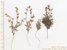 Coll. No. 336 turned out to be a mixed collection. Coll. No. 336 turned out to be a mixed collection.
|
Collection No. 336 turned out to be a mixed collection of two different Pectocaryas. | |||||||||||||||||||||||||||||||||||||||||||||||||||||||||||||||||||||||||||||||||||||||||||||||||||||||||||||||||||||||||||||||||||||||||||||||||||||||||||||||||||||||||||||||||||||||||||||||||||||||||||||||||||||||||||||||||||||||||||||||||||||||||||||||||||||||||||||||||||||||||||||||||||||||||||||||||||||||||||||||||||||||||||||||||||||||||||||||||||||||||||||||||||||||||||||||||||||||||||||||||||||||||||||||||||||||||||||||||||||||||||||||||||||||||||||||||||||||||||||||||||||||||||||||||||||||||||||||||||||||||||||||||||||||||||||||||||||||||||||||||||||||||||||||||||||||||||||||||||||||||||||||||||||||||||||||||||||||||||||||||||||||||||||
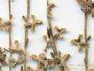 Coll. No. 336.1, Pectocarya heterocarpa Coll. No. 336.1, Pectocarya heterocarpa
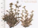 Coll. No. 336.1, Pectocarya heterocarpa Coll. No. 336.1, Pectocarya heterocarpa
|
336.1 |
Pectocarya heterocarpa (I.M. Johnst.) I.M. Johnst. Mixed-Nut Combseed.
Shadow Valley, San Bernardino County, California. In Creosote Bush scrub, on Kingston Road about 0.4 mi north of the intersection with Excelsior Mine Road, climbing to Winters Pass in the Mesquite Mountains. 35.6152°N, 115.7295°W. WGS 1984. Elev. 1080 m. Coll. No. 336.1, 20 Apr 2012, characters observed while keying: Annual, green / non-parasitic; Pedicel partly fused to one nutlet; Corolla white; Nutlets 4, spreading, paired, oblong, dissimilar, curved in 2 planes, margins dentate, of 1 pair narrow, of the other pair wide. | ||||||||||||||||||||||||||||||||||||||||||||||||||||||||||||||||||||||||||||||||||||||||||||||||||||||||||||||||||||||||||||||||||||||||||||||||||||||||||||||||||||||||||||||||||||||||||||||||||||||||||||||||||||||||||||||||||||||||||||||||||||||||||||||||||||||||||||||||||||||||||||||||||||||||||||||||||||||||||||||||||||||||||||||||||||||||||||||||||||||||||||||||||||||||||||||||||||||||||||||||||||||||||||||||||||||||||||||||||||||||||||||||||||||||||||||||||||||||||||||||||||||||||||||||||||||||||||||||||||||||||||||||||||||||||||||||||||||||||||||||||||||||||||||||||||||||||||||||||||||||||||||||||||||||||||||||||||||||||||||||||||||||||||
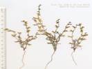 Coll. No. 336.2, Pectocarya platycarpa Coll. No. 336.2, Pectocarya platycarpa
|
336.2 |
Pectocarya platycarpa (Munz & I.M. Johnst.) Munz & I.M. Johnst. Broad-Fruited Combseed.
Shadow Valley, San Bernardino County, California. In Creosote Bush scrub, on Kingston Road about 0.4 mi north of the intersection with Excelsior Mine Road, climbing to Winters Pass in the Mesquite Mountains. 35.6152°N, 115.7295°W. WGS 1984. Elev. 1080 m. Coll. No. 336.2, 20 Apr 2012, characters observed while keying: Annual, green / non-parasitic; Stem ascending; Pedicel free from nutlets; Corolla color unknown (should be white); Nutlets 4, spreading, paired, oblong, similar, straight, margins dentate, margin teeth width about equal length. | ||||||||||||||||||||||||||||||||||||||||||||||||||||||||||||||||||||||||||||||||||||||||||||||||||||||||||||||||||||||||||||||||||||||||||||||||||||||||||||||||||||||||||||||||||||||||||||||||||||||||||||||||||||||||||||||||||||||||||||||||||||||||||||||||||||||||||||||||||||||||||||||||||||||||||||||||||||||||||||||||||||||||||||||||||||||||||||||||||||||||||||||||||||||||||||||||||||||||||||||||||||||||||||||||||||||||||||||||||||||||||||||||||||||||||||||||||||||||||||||||||||||||||||||||||||||||||||||||||||||||||||||||||||||||||||||||||||||||||||||||||||||||||||||||||||||||||||||||||||||||||||||||||||||||||||||||||||||||||||||||||||||||||||
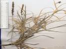 Coll. No. 337, Hilaria rigida Coll. No. 337, Hilaria rigida
|
337 |
Hilaria rigida (Thurb.) Scribn. Big Galleta.
Mesquite Mountains, San Bernardino County, California. In Creosote Bush scrub on Kingston Road, 3 miles south of the Winters Pass Hills, 12 miles north of Valley Wells, climbing to Winters Pass in the Mesquite Mountains. 35.6152°N, 115.7295°W. WGS 1984. Elev. 1080 m. Coll. No. 337, 10 June 2012, characters observed while keying: Perennial, mid-sized, to 30 cm., strongly tillered as plant axis lengthens; Internodes filled with pith; Leaf differentiated into sheath and blade, variously tomentose; Sheath open; Ligule membrane, divided into cilia; Inflorescence spike-like, 8 cm., well-developed, unbranched zig-zag central axis; Disarticulation cluster of 3 spikelets falling as a unit; Spikelets many, in clusters 3 per node, hairy at base, sessile or nearly so; Florets variously staminate or bisexual; Central floret: Glumes divided into 3-5 awn-like segments; Lemma veins 3, 1 awn from back, tip divided and ciliate; Lateral floret: Lower glume 1+ awn-like segment; Upper glume awn 0; Stigma: feathery ciliate when present. | ||||||||||||||||||||||||||||||||||||||||||||||||||||||||||||||||||||||||||||||||||||||||||||||||||||||||||||||||||||||||||||||||||||||||||||||||||||||||||||||||||||||||||||||||||||||||||||||||||||||||||||||||||||||||||||||||||||||||||||||||||||||||||||||||||||||||||||||||||||||||||||||||||||||||||||||||||||||||||||||||||||||||||||||||||||||||||||||||||||||||||||||||||||||||||||||||||||||||||||||||||||||||||||||||||||||||||||||||||||||||||||||||||||||||||||||||||||||||||||||||||||||||||||||||||||||||||||||||||||||||||||||||||||||||||||||||||||||||||||||||||||||||||||||||||||||||||||||||||||||||||||||||||||||||||||||||||||||||||||||||||||||||||||
|
Other articles:
|
337.1 |
Baileya multiradiata Harv. & A. Gray ex Torr. Desert Marigold.
Mesquite Mountains, San Bernardino County, California. In Creosote Bush scrub, just west of the Winters Pass Hills, on Kingston Road, climbing to Winters Pass in the Mesquite Mountains. 35.6784°N, 115.7062°W. WGS 1984. Elev. 1080 m. Coll. No. 337.1, 20 Apr 2004, characters observed while keying: Annual (biennial or short-lived perennial), to 40 cm., ±gray-tomentose, scapose; Leaves alternate; Inflorescence, heads solitary, flowers of two kinds, some with strap-shaped corollas; Involucre 6 mm.; Phyllaries, in 2+ series, slightly overlapping, ±equal, erect; Receptacle, hemispheric, epaleate; Pappus 0; Ray flowers, many, corolla, yellow, 13 mm. × 9 mm. wide, 3-lobed, when dry persistent papery reflexed; Fruit achene, 3.5 mm., ±equally ribbed. | ||||||||||||||||||||||||||||||||||||||||||||||||||||||||||||||||||||||||||||||||||||||||||||||||||||||||||||||||||||||||||||||||||||||||||||||||||||||||||||||||||||||||||||||||||||||||||||||||||||||||||||||||||||||||||||||||||||||||||||||||||||||||||||||||||||||||||||||||||||||||||||||||||||||||||||||||||||||||||||||||||||||||||||||||||||||||||||||||||||||||||||||||||||||||||||||||||||||||||||||||||||||||||||||||||||||||||||||||||||||||||||||||||||||||||||||||||||||||||||||||||||||||||||||||||||||||||||||||||||||||||||||||||||||||||||||||||||||||||||||||||||||||||||||||||||||||||||||||||||||||||||||||||||||||||||||||||||||||||||||||||||||||||||
| 338 | Composite | |||||||||||||||||||||||||||||||||||||||||||||||||||||||||||||||||||||||||||||||||||||||||||||||||||||||||||||||||||||||||||||||||||||||||||||||||||||||||||||||||||||||||||||||||||||||||||||||||||||||||||||||||||||||||||||||||||||||||||||||||||||||||||||||||||||||||||||||||||||||||||||||||||||||||||||||||||||||||||||||||||||||||||||||||||||||||||||||||||||||||||||||||||||||||||||||||||||||||||||||||||||||||||||||||||||||||||||||||||||||||||||||||||||||||||||||||||||||||||||||||||||||||||||||||||||||||||||||||||||||||||||||||||||||||||||||||||||||||||||||||||||||||||||||||||||||||||||||||||||||||||||||||||||||||||||||||||||||||||||||||||||||||||||
| Unknown (may be labeled #0338) | ||||||||||||||||||||||||||||||||||||||||||||||||||||||||||||||||||||||||||||||||||||||||||||||||||||||||||||||||||||||||||||||||||||||||||||||||||||||||||||||||||||||||||||||||||||||||||||||||||||||||||||||||||||||||||||||||||||||||||||||||||||||||||||||||||||||||||||||||||||||||||||||||||||||||||||||||||||||||||||||||||||||||||||||||||||||||||||||||||||||||||||||||||||||||||||||||||||||||||||||||||||||||||||||||||||||||||||||||||||||||||||||||||||||||||||||||||||||||||||||||||||||||||||||||||||||||||||||||||||||||||||||||||||||||||||||||||||||||||||||||||||||||||||||||||||||||||||||||||||||||||||||||||||||||||||||||||||||||||||||||||||||||||||||
| Eriophyllum | ||||||||||||||||||||||||||||||||||||||||||||||||||||||||||||||||||||||||||||||||||||||||||||||||||||||||||||||||||||||||||||||||||||||||||||||||||||||||||||||||||||||||||||||||||||||||||||||||||||||||||||||||||||||||||||||||||||||||||||||||||||||||||||||||||||||||||||||||||||||||||||||||||||||||||||||||||||||||||||||||||||||||||||||||||||||||||||||||||||||||||||||||||||||||||||||||||||||||||||||||||||||||||||||||||||||||||||||||||||||||||||||||||||||||||||||||||||||||||||||||||||||||||||||||||||||||||||||||||||||||||||||||||||||||||||||||||||||||||||||||||||||||||||||||||||||||||||||||||||||||||||||||||||||||||||||||||||||||||||||||||||||||||||||
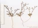 Coll. No. 340.1, Chorizanthe brevicornu var. brevicornu Coll. No. 340.1, Chorizanthe brevicornu var. brevicornu
|
340.1 |
Chorizanthe brevicornu Torr. var. brevicornu. Brittle Spineflower.
Shadow Valley, San Bernardino County, California. In Creosote Bush scrub, just west of the Winters Pass Hills, on Kingston Road, about 0.4 mi north of its intersection with Excelsior Mine Road, climbing to Winters Pass in the Mesquite Mountains. 35.6784°N, 115.7062°W. WGS 1984. Elev. 1080 m. | ||||||||||||||||||||||||||||||||||||||||||||||||||||||||||||||||||||||||||||||||||||||||||||||||||||||||||||||||||||||||||||||||||||||||||||||||||||||||||||||||||||||||||||||||||||||||||||||||||||||||||||||||||||||||||||||||||||||||||||||||||||||||||||||||||||||||||||||||||||||||||||||||||||||||||||||||||||||||||||||||||||||||||||||||||||||||||||||||||||||||||||||||||||||||||||||||||||||||||||||||||||||||||||||||||||||||||||||||||||||||||||||||||||||||||||||||||||||||||||||||||||||||||||||||||||||||||||||||||||||||||||||||||||||||||||||||||||||||||||||||||||||||||||||||||||||||||||||||||||||||||||||||||||||||||||||||||||||||||||||||||||||||||||
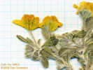 Collection No. 340.2, Eriophyllum wallacei, woolly easterbonnets. Collection No. 340.2, Eriophyllum wallacei, woolly easterbonnets.
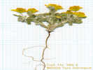 Collection No. 340.2, Eriophyllum wallacei, woolly easterbonnets. Collection No. 340.2, Eriophyllum wallacei, woolly easterbonnets.
|
340.2 | Eriophyllum wallacei (A. Gray) A. Gray. Woolly easterbonnets, in Creosote Bush scrub, south of the Winters Pass Hills, 13 mi (20.9 km) north of Valley Wells, 5.2 mi (8.4 km) south-southwest of Winters Pass. | ||||||||||||||||||||||||||||||||||||||||||||||||||||||||||||||||||||||||||||||||||||||||||||||||||||||||||||||||||||||||||||||||||||||||||||||||||||||||||||||||||||||||||||||||||||||||||||||||||||||||||||||||||||||||||||||||||||||||||||||||||||||||||||||||||||||||||||||||||||||||||||||||||||||||||||||||||||||||||||||||||||||||||||||||||||||||||||||||||||||||||||||||||||||||||||||||||||||||||||||||||||||||||||||||||||||||||||||||||||||||||||||||||||||||||||||||||||||||||||||||||||||||||||||||||||||||||||||||||||||||||||||||||||||||||||||||||||||||||||||||||||||||||||||||||||||||||||||||||||||||||||||||||||||||||||||||||||||||||||||||||||||||||||
|
Literature Cited:
Other articles:
Locations: Winters Pass Hills. |
In Corsetti and Kaufman (2003), I read that some tubular structures could be found in the Noonday Dolomite of the Winters Pass Hills. The Winters Pass Hills are the Southernmost outcrop of the Noonday and Johnnie Formations they studied. The hill shown in the photograph is the southernmost of the Winters Pass Hills. It is also right beside the road. So, I decided to walk up to the outcrops to see if I could find the tubes. Somehow, though, I got in my head that the tubes were supposed to be scolithos. While I could see many tubular features in the rocks, none of them looked like the photographs of scolithos I have seen elsewhere. So these original field notes stated that there were supposed to be scolithos here but that I did not find them. About a year and a half later, Frank Corsetti saw my field notes and wrote to me to say that the tubes in the Noonday are not scolithos. I went back and read his paper and, sure enough, the paper is quite clear when it says there are tubular structures in the Noonday and it does not say they are scolithos. Therefore, in retrospect, I had probably found the structures I was looking for, but did not recognize them, because I thought I was looking for something else. I'm not sure how I got scolithos in my head. But, you can sure send yourself off on a wild goose chase sometimes. On the way back to the car, however, I did find a large colony of Langloisia from which I made a collection. | |||||||||||||||||||||||||||||||||||||||||||||||||||||||||||||||||||||||||||||||||||||||||||||||||||||||||||||||||||||||||||||||||||||||||||||||||||||||||||||||||||||||||||||||||||||||||||||||||||||||||||||||||||||||||||||||||||||||||||||||||||||||||||||||||||||||||||||||||||||||||||||||||||||||||||||||||||||||||||||||||||||||||||||||||||||||||||||||||||||||||||||||||||||||||||||||||||||||||||||||||||||||||||||||||||||||||||||||||||||||||||||||||||||||||||||||||||||||||||||||||||||||||||||||||||||||||||||||||||||||||||||||||||||||||||||||||||||||||||||||||||||||||||||||||||||||||||||||||||||||||||||||||||||||||||||||||||||||||||||||||||||||||||||
|
Other articles:
|
On the way up to the outcrop, I saw some fine specimens in bloom. One was a Mojave Prickly Pear (Opuntia erinacea) and the other was Parish's Larkspur (Delphinium parishii). | |||||||||||||||||||||||||||||||||||||||||||||||||||||||||||||||||||||||||||||||||||||||||||||||||||||||||||||||||||||||||||||||||||||||||||||||||||||||||||||||||||||||||||||||||||||||||||||||||||||||||||||||||||||||||||||||||||||||||||||||||||||||||||||||||||||||||||||||||||||||||||||||||||||||||||||||||||||||||||||||||||||||||||||||||||||||||||||||||||||||||||||||||||||||||||||||||||||||||||||||||||||||||||||||||||||||||||||||||||||||||||||||||||||||||||||||||||||||||||||||||||||||||||||||||||||||||||||||||||||||||||||||||||||||||||||||||||||||||||||||||||||||||||||||||||||||||||||||||||||||||||||||||||||||||||||||||||||||||||||||||||||||||||||
|
Other articles:
Locations:
Winters Pass.
|
From my vantage point on the low Winters Pass Hills, I got a better sense of Winters Pass being a low, broad pass separating the North and South Mesquite Mountains. | |||||||||||||||||||||||||||||||||||||||||||||||||||||||||||||||||||||||||||||||||||||||||||||||||||||||||||||||||||||||||||||||||||||||||||||||||||||||||||||||||||||||||||||||||||||||||||||||||||||||||||||||||||||||||||||||||||||||||||||||||||||||||||||||||||||||||||||||||||||||||||||||||||||||||||||||||||||||||||||||||||||||||||||||||||||||||||||||||||||||||||||||||||||||||||||||||||||||||||||||||||||||||||||||||||||||||||||||||||||||||||||||||||||||||||||||||||||||||||||||||||||||||||||||||||||||||||||||||||||||||||||||||||||||||||||||||||||||||||||||||||||||||||||||||||||||||||||||||||||||||||||||||||||||||||||||||||||||||||||||||||||||||||||
| At 16 miles, entering Winters Pass Hills. The vegetation hasn't changed much. A few Apricot Mallow were seen. UTM location: 11S 0616600 3946658, elevation by GPS is 1085 m. | ||||||||||||||||||||||||||||||||||||||||||||||||||||||||||||||||||||||||||||||||||||||||||||||||||||||||||||||||||||||||||||||||||||||||||||||||||||||||||||||||||||||||||||||||||||||||||||||||||||||||||||||||||||||||||||||||||||||||||||||||||||||||||||||||||||||||||||||||||||||||||||||||||||||||||||||||||||||||||||||||||||||||||||||||||||||||||||||||||||||||||||||||||||||||||||||||||||||||||||||||||||||||||||||||||||||||||||||||||||||||||||||||||||||||||||||||||||||||||||||||||||||||||||||||||||||||||||||||||||||||||||||||||||||||||||||||||||||||||||||||||||||||||||||||||||||||||||||||||||||||||||||||||||||||||||||||||||||||||||||||||||||||||||||
|
Other articles:
|
341 |
| ||||||||||||||||||||||||||||||||||||||||||||||||||||||||||||||||||||||||||||||||||||||||||||||||||||||||||||||||||||||||||||||||||||||||||||||||||||||||||||||||||||||||||||||||||||||||||||||||||||||||||||||||||||||||||||||||||||||||||||||||||||||||||||||||||||||||||||||||||||||||||||||||||||||||||||||||||||||||||||||||||||||||||||||||||||||||||||||||||||||||||||||||||||||||||||||||||||||||||||||||||||||||||||||||||||||||||||||||||||||||||||||||||||||||||||||||||||||||||||||||||||||||||||||||||||||||||||||||||||||||||||||||||||||||||||||||||||||||||||||||||||||||||||||||||||||||||||||||||||||||||||||||||||||||||||||||||||||||||||||||||||||||||||
|
Other articles:
Locations:
Mesquite Mountains.
|
| |||||||||||||||||||||||||||||||||||||||||||||||||||||||||||||||||||||||||||||||||||||||||||||||||||||||||||||||||||||||||||||||||||||||||||||||||||||||||||||||||||||||||||||||||||||||||||||||||||||||||||||||||||||||||||||||||||||||||||||||||||||||||||||||||||||||||||||||||||||||||||||||||||||||||||||||||||||||||||||||||||||||||||||||||||||||||||||||||||||||||||||||||||||||||||||||||||||||||||||||||||||||||||||||||||||||||||||||||||||||||||||||||||||||||||||||||||||||||||||||||||||||||||||||||||||||||||||||||||||||||||||||||||||||||||||||||||||||||||||||||||||||||||||||||||||||||||||||||||||||||||||||||||||||||||||||||||||||||||||||||||||||||||||
|
Other articles:
|
342 |
Xylorhiza tortifolia (Torr. & A. Gray) Greene var. tortifolia. Mojave Woody Aster.
Winters Pass, San Bernardino County, California. Winters Pass is on Kingston Road where it passes through the Mesquite Mountains. Plants were found on stony-mantled ground on the small hill just west of the pass. 35.6883°N, 115.7037°W. WGS 1984. Elev. 1170 m. Coll. No. 342, 20 April 2004, characters observed while keying: Perennial, to 30 cm., glandless; Stem ascending, wooly; Leaves, cauline, alternate, lanceolate, 45 mm. × 5 mm. wide, margins wavy, spiny-dentate, tip spined; Inflorescence, large heads solitary on 5+ cm. peduncles, flowers of two kinds, rays ligulate, radiate; Phyllaries, in 3 series, overlapping, not in vertical ranks, inner longer and thinner, 6,7,8 mm. × 1.5- 1.0 mm. wide, without oil glands; Receptacle, hemispheric or conic, epaleate; Pappus, well developed bristles, ≥24, disc pappus single, cylindric; Corolla, rays 20 mm. blue, disc yellow; Fruit, 3 mm. | ||||||||||||||||||||||||||||||||||||||||||||||||||||||||||||||||||||||||||||||||||||||||||||||||||||||||||||||||||||||||||||||||||||||||||||||||||||||||||||||||||||||||||||||||||||||||||||||||||||||||||||||||||||||||||||||||||||||||||||||||||||||||||||||||||||||||||||||||||||||||||||||||||||||||||||||||||||||||||||||||||||||||||||||||||||||||||||||||||||||||||||||||||||||||||||||||||||||||||||||||||||||||||||||||||||||||||||||||||||||||||||||||||||||||||||||||||||||||||||||||||||||||||||||||||||||||||||||||||||||||||||||||||||||||||||||||||||||||||||||||||||||||||||||||||||||||||||||||||||||||||||||||||||||||||||||||||||||||||||||||||||||||||||
|
Other articles:
|
343 |
Amsinckia tessellata A. Gray var. tessellata. Bristly Fiddleneck.
Winters Pass, San Bernardino County, California. Winters Pass is on Kingston Road where it passes through the Mesquite Mountains, 12.7 miles north of US Interstate 15 Exit 272 at Cima Road, then 5.7 miles north northwest on Kingston Road. 35.6884°N, 115.7036°W. WGS 1984. Elev. 1170 m. Plants were found on stony-mantled ground on the small hill just north of the pass. Coll. No. 343, 20 April 2004, characters observed: Annual, to 30 cm.; Stem hairy, Leaf, alternate, 65 mm. × 14 mm., entire, hairy; Inflorescence, coiled raceme-like spikes; Calyx lobes 3, 2 are notched at tip, white hairy; Corolla, short (8 mm. when dry), orange; Receptacle (should be conical, since the scar is lateral, but not as conspicuous as in Cryptantha); Anthers (fill floral tube and are probably appressed to stigma); Nutlets, #3, deltate, 3 mm. × 2.5 mm. × 1.5 mm., erect, scar lateral, exposed, flat, without thick rim, surface cobblestone-like, margin prickles 0. | ||||||||||||||||||||||||||||||||||||||||||||||||||||||||||||||||||||||||||||||||||||||||||||||||||||||||||||||||||||||||||||||||||||||||||||||||||||||||||||||||||||||||||||||||||||||||||||||||||||||||||||||||||||||||||||||||||||||||||||||||||||||||||||||||||||||||||||||||||||||||||||||||||||||||||||||||||||||||||||||||||||||||||||||||||||||||||||||||||||||||||||||||||||||||||||||||||||||||||||||||||||||||||||||||||||||||||||||||||||||||||||||||||||||||||||||||||||||||||||||||||||||||||||||||||||||||||||||||||||||||||||||||||||||||||||||||||||||||||||||||||||||||||||||||||||||||||||||||||||||||||||||||||||||||||||||||||||||||||||||||||||||||||||
|
Other articles:
|
344 |
Lupinus flavoculatus A. Heller. Yellow Eyes.
Winters Pass, San Bernardino County, California. Winters Pass is on Kingston Road where it passes through the Mesquite Mountains. Plants were found on stony-mantled ground on the small hill just north of the pass. 35.6882°N, 115.7036°W. WGS 1984. Elev. 1170 m. Coll. No. 344, keyed 6 Dec 2012, characters observed: Annual 3.5 - 5.5 cm.; Cotyledons sessile, persistent, disk-like; Leaves cauline, crowded near base, free blades of stipules 2 mm., palmate, sparse long hairy at flowering; Leaflet 8-9 mm.; Peduncle 11-22 mm.; Inflorescence 25-30 mm., not distinctly whorled, many-flowered; Pedicel 2 mm.; Calyx appendages 0; Banner blue-violet with prominent yellow spot, back glabrous; Wings; Keel glabrous. | ||||||||||||||||||||||||||||||||||||||||||||||||||||||||||||||||||||||||||||||||||||||||||||||||||||||||||||||||||||||||||||||||||||||||||||||||||||||||||||||||||||||||||||||||||||||||||||||||||||||||||||||||||||||||||||||||||||||||||||||||||||||||||||||||||||||||||||||||||||||||||||||||||||||||||||||||||||||||||||||||||||||||||||||||||||||||||||||||||||||||||||||||||||||||||||||||||||||||||||||||||||||||||||||||||||||||||||||||||||||||||||||||||||||||||||||||||||||||||||||||||||||||||||||||||||||||||||||||||||||||||||||||||||||||||||||||||||||||||||||||||||||||||||||||||||||||||||||||||||||||||||||||||||||||||||||||||||||||||||||||||||||||||||
| 345 | Chorizanthe ridiga | |||||||||||||||||||||||||||||||||||||||||||||||||||||||||||||||||||||||||||||||||||||||||||||||||||||||||||||||||||||||||||||||||||||||||||||||||||||||||||||||||||||||||||||||||||||||||||||||||||||||||||||||||||||||||||||||||||||||||||||||||||||||||||||||||||||||||||||||||||||||||||||||||||||||||||||||||||||||||||||||||||||||||||||||||||||||||||||||||||||||||||||||||||||||||||||||||||||||||||||||||||||||||||||||||||||||||||||||||||||||||||||||||||||||||||||||||||||||||||||||||||||||||||||||||||||||||||||||||||||||||||||||||||||||||||||||||||||||||||||||||||||||||||||||||||||||||||||||||||||||||||||||||||||||||||||||||||||||||||||||||||||||||||||
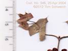 Coll. No. 346, Oxytheca perfoliata Coll. No. 346, Oxytheca perfoliata
|
346 |
Oxytheca perfoliata Torr. & A. Gray. Round-Leaf Puncturebract.
Coll. No. 346, 20 Apr 2004, characters observed while keying: Annual; Stem ocreae absent, glandular proximal 1/2 internode; Leaves basal, oblanceolate to 15 mm., entire; Involucre bell-shaped (not tubular per TJM2), bracts 4, fused at base, awns 4 2.0-2.5 mm.; Perianth hairy. | ||||||||||||||||||||||||||||||||||||||||||||||||||||||||||||||||||||||||||||||||||||||||||||||||||||||||||||||||||||||||||||||||||||||||||||||||||||||||||||||||||||||||||||||||||||||||||||||||||||||||||||||||||||||||||||||||||||||||||||||||||||||||||||||||||||||||||||||||||||||||||||||||||||||||||||||||||||||||||||||||||||||||||||||||||||||||||||||||||||||||||||||||||||||||||||||||||||||||||||||||||||||||||||||||||||||||||||||||||||||||||||||||||||||||||||||||||||||||||||||||||||||||||||||||||||||||||||||||||||||||||||||||||||||||||||||||||||||||||||||||||||||||||||||||||||||||||||||||||||||||||||||||||||||||||||||||||||||||||||||||||||||||||||
|
Other articles:
|
347 |
Cryptantha pterocarya (Torr.) Greene var. cycloptera (Greene) J. F. Macbr. Tucson Cryptantha. Winters Pass, San Bernardino County, California. Winters Pass is on Kingston Road where it passes through the Mesquite Mountains. Plants were found on stony-mantled ground on the small hill just west of the pass. 35.6899°N, 115.7038°W. Elev. 1170 m. Nutlets: 4, all winged alike.
| ||||||||||||||||||||||||||||||||||||||||||||||||||||||||||||||||||||||||||||||||||||||||||||||||||||||||||||||||||||||||||||||||||||||||||||||||||||||||||||||||||||||||||||||||||||||||||||||||||||||||||||||||||||||||||||||||||||||||||||||||||||||||||||||||||||||||||||||||||||||||||||||||||||||||||||||||||||||||||||||||||||||||||||||||||||||||||||||||||||||||||||||||||||||||||||||||||||||||||||||||||||||||||||||||||||||||||||||||||||||||||||||||||||||||||||||||||||||||||||||||||||||||||||||||||||||||||||||||||||||||||||||||||||||||||||||||||||||||||||||||||||||||||||||||||||||||||||||||||||||||||||||||||||||||||||||||||||||||||||||||||||||||||||
|
Other articles:
|
348 |
Chaenactis carphoclinia A. Gray var. carphoclinia. Pebble Pincushion.
Winters Pass, San Bernardino County, California. Winters Pass is on Kingston Road where it passes through the Mesquite Mountains. Plants were found on stony-mantled ground on the small hill just west of the pass. 35.6899°N, 115.7038°W. WGS 1984. Elev. 1170 m. Coll. No. 348, 20 April 2004, characters observed while keying: Annual, to 20 cm., tap-rooted; Leaves, basal and cauline, to 40 mm., finely pinnately 2° divided, margins not spiny; Inflorescence, no strap-shaped flowers, flowers of 1 kind; Phyllaries, in 2 overlapping series; Receptacle paleate, 9 mm., appearing ≥1 mm. above buds; Pappus of short, 0.6 mm., scales. | ||||||||||||||||||||||||||||||||||||||||||||||||||||||||||||||||||||||||||||||||||||||||||||||||||||||||||||||||||||||||||||||||||||||||||||||||||||||||||||||||||||||||||||||||||||||||||||||||||||||||||||||||||||||||||||||||||||||||||||||||||||||||||||||||||||||||||||||||||||||||||||||||||||||||||||||||||||||||||||||||||||||||||||||||||||||||||||||||||||||||||||||||||||||||||||||||||||||||||||||||||||||||||||||||||||||||||||||||||||||||||||||||||||||||||||||||||||||||||||||||||||||||||||||||||||||||||||||||||||||||||||||||||||||||||||||||||||||||||||||||||||||||||||||||||||||||||||||||||||||||||||||||||||||||||||||||||||||||||||||||||||||||||||
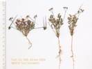 Coll. No. 349, Erodium cicutarium Coll. No. 349, Erodium cicutarium
|
349 |
Erodium cicutarium (L.) L'Her. ex Aiton. Redstem Stork's Bill.
Winters Pass, San Bernardino County, California. Winters Pass is on Kingston Road where it passes through the Mesquite Mountains. Plants were found on stony-mantled ground on the small hill just north of the pass. 35.6883°N, 115.7035°W. WGS 1984. Elev. 1170 m. | ||||||||||||||||||||||||||||||||||||||||||||||||||||||||||||||||||||||||||||||||||||||||||||||||||||||||||||||||||||||||||||||||||||||||||||||||||||||||||||||||||||||||||||||||||||||||||||||||||||||||||||||||||||||||||||||||||||||||||||||||||||||||||||||||||||||||||||||||||||||||||||||||||||||||||||||||||||||||||||||||||||||||||||||||||||||||||||||||||||||||||||||||||||||||||||||||||||||||||||||||||||||||||||||||||||||||||||||||||||||||||||||||||||||||||||||||||||||||||||||||||||||||||||||||||||||||||||||||||||||||||||||||||||||||||||||||||||||||||||||||||||||||||||||||||||||||||||||||||||||||||||||||||||||||||||||||||||||||||||||||||||||||||||
| Rock outcrop north of road. | ||||||||||||||||||||||||||||||||||||||||||||||||||||||||||||||||||||||||||||||||||||||||||||||||||||||||||||||||||||||||||||||||||||||||||||||||||||||||||||||||||||||||||||||||||||||||||||||||||||||||||||||||||||||||||||||||||||||||||||||||||||||||||||||||||||||||||||||||||||||||||||||||||||||||||||||||||||||||||||||||||||||||||||||||||||||||||||||||||||||||||||||||||||||||||||||||||||||||||||||||||||||||||||||||||||||||||||||||||||||||||||||||||||||||||||||||||||||||||||||||||||||||||||||||||||||||||||||||||||||||||||||||||||||||||||||||||||||||||||||||||||||||||||||||||||||||||||||||||||||||||||||||||||||||||||||||||||||||||||||||||||||||||||||
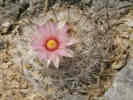 Foxtail cactus (Mammilaria tetrancistra) on limestone outcrop in Mesquite Mountains. Foxtail cactus (Mammilaria tetrancistra) on limestone outcrop in Mesquite Mountains.
|
||||||||||||||||||||||||||||||||||||||||||||||||||||||||||||||||||||||||||||||||||||||||||||||||||||||||||||||||||||||||||||||||||||||||||||||||||||||||||||||||||||||||||||||||||||||||||||||||||||||||||||||||||||||||||||||||||||||||||||||||||||||||||||||||||||||||||||||||||||||||||||||||||||||||||||||||||||||||||||||||||||||||||||||||||||||||||||||||||||||||||||||||||||||||||||||||||||||||||||||||||||||||||||||||||||||||||||||||||||||||||||||||||||||||||||||||||||||||||||||||||||||||||||||||||||||||||||||||||||||||||||||||||||||||||||||||||||||||||||||||||||||||||||||||||||||||||||||||||||||||||||||||||||||||||||||||||||||||||||||||||||||||||||||
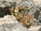 Undetermined species found in limestone outcrop on east side of Mesquite Mountains. Undetermined species found in limestone outcrop on east side of Mesquite Mountains.
|
Unknown plant in crack of limestone outcrop -- Nama dichotomum ??? | |||||||||||||||||||||||||||||||||||||||||||||||||||||||||||||||||||||||||||||||||||||||||||||||||||||||||||||||||||||||||||||||||||||||||||||||||||||||||||||||||||||||||||||||||||||||||||||||||||||||||||||||||||||||||||||||||||||||||||||||||||||||||||||||||||||||||||||||||||||||||||||||||||||||||||||||||||||||||||||||||||||||||||||||||||||||||||||||||||||||||||||||||||||||||||||||||||||||||||||||||||||||||||||||||||||||||||||||||||||||||||||||||||||||||||||||||||||||||||||||||||||||||||||||||||||||||||||||||||||||||||||||||||||||||||||||||||||||||||||||||||||||||||||||||||||||||||||||||||||||||||||||||||||||||||||||||||||||||||||||||||||||||||||
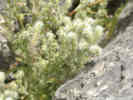 Undetermined species found in limestone outcrop on east side of Mesquite Mountains. Undetermined species found in limestone outcrop on east side of Mesquite Mountains.
|
Unknown plant in crack of limestone outcrop -- Boraginaceae? Cryptantha? | |||||||||||||||||||||||||||||||||||||||||||||||||||||||||||||||||||||||||||||||||||||||||||||||||||||||||||||||||||||||||||||||||||||||||||||||||||||||||||||||||||||||||||||||||||||||||||||||||||||||||||||||||||||||||||||||||||||||||||||||||||||||||||||||||||||||||||||||||||||||||||||||||||||||||||||||||||||||||||||||||||||||||||||||||||||||||||||||||||||||||||||||||||||||||||||||||||||||||||||||||||||||||||||||||||||||||||||||||||||||||||||||||||||||||||||||||||||||||||||||||||||||||||||||||||||||||||||||||||||||||||||||||||||||||||||||||||||||||||||||||||||||||||||||||||||||||||||||||||||||||||||||||||||||||||||||||||||||||||||||||||||||||||||
|
Other articles:
|
From the top of the limestone outcrop, I had a good view of Mesquite Lake and Mesquite Valley. | |||||||||||||||||||||||||||||||||||||||||||||||||||||||||||||||||||||||||||||||||||||||||||||||||||||||||||||||||||||||||||||||||||||||||||||||||||||||||||||||||||||||||||||||||||||||||||||||||||||||||||||||||||||||||||||||||||||||||||||||||||||||||||||||||||||||||||||||||||||||||||||||||||||||||||||||||||||||||||||||||||||||||||||||||||||||||||||||||||||||||||||||||||||||||||||||||||||||||||||||||||||||||||||||||||||||||||||||||||||||||||||||||||||||||||||||||||||||||||||||||||||||||||||||||||||||||||||||||||||||||||||||||||||||||||||||||||||||||||||||||||||||||||||||||||||||||||||||||||||||||||||||||||||||||||||||||||||||||||||||||||||||||||||
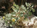 Ivy-Leaved Ground Cherry (Physalis hederifolia) on limestone outcrop, east side of Mesquite Mountains. Ivy-Leaved Ground Cherry (Physalis hederifolia) on limestone outcrop, east side of Mesquite Mountains.
|
||||||||||||||||||||||||||||||||||||||||||||||||||||||||||||||||||||||||||||||||||||||||||||||||||||||||||||||||||||||||||||||||||||||||||||||||||||||||||||||||||||||||||||||||||||||||||||||||||||||||||||||||||||||||||||||||||||||||||||||||||||||||||||||||||||||||||||||||||||||||||||||||||||||||||||||||||||||||||||||||||||||||||||||||||||||||||||||||||||||||||||||||||||||||||||||||||||||||||||||||||||||||||||||||||||||||||||||||||||||||||||||||||||||||||||||||||||||||||||||||||||||||||||||||||||||||||||||||||||||||||||||||||||||||||||||||||||||||||||||||||||||||||||||||||||||||||||||||||||||||||||||||||||||||||||||||||||||||||||||||||||||||||||||
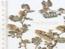 Coll. No. 350, Dalea mollis Coll. No. 350, Dalea mollis
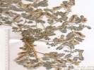 Coll. No. 350, Dalea mollis Coll. No. 350, Dalea mollis
|
350 |
Dalea mollis Benth. Hairy Prairie Clover.
Mesquite Mountains, San Bernardino County, California. On disturbed ground, along Kingston Road, 3.6 mi (5.7 km) northeast of Winters Pass. 35.7299°N, 115.6726°W. WGS 1984. Elev. 990 m. Coll. No. 350, 20 Apr 2004, characters observed while keying: Annual; Stem gland-dotted; Stipules present; Leaf pinnately compound; Leaflets 8-12, 5 mm. x 4 mm. wide, main axis ending as a leaflet, abaxially dark gland-dotted; Calyx 4-5 mm. Small size of calyx and flatness of leaflets suggest D. mollis rather than D. mollissima. | ||||||||||||||||||||||||||||||||||||||||||||||||||||||||||||||||||||||||||||||||||||||||||||||||||||||||||||||||||||||||||||||||||||||||||||||||||||||||||||||||||||||||||||||||||||||||||||||||||||||||||||||||||||||||||||||||||||||||||||||||||||||||||||||||||||||||||||||||||||||||||||||||||||||||||||||||||||||||||||||||||||||||||||||||||||||||||||||||||||||||||||||||||||||||||||||||||||||||||||||||||||||||||||||||||||||||||||||||||||||||||||||||||||||||||||||||||||||||||||||||||||||||||||||||||||||||||||||||||||||||||||||||||||||||||||||||||||||||||||||||||||||||||||||||||||||||||||||||||||||||||||||||||||||||||||||||||||||||||||||||||||||||||||
| 351 | Nicotiana | |||||||||||||||||||||||||||||||||||||||||||||||||||||||||||||||||||||||||||||||||||||||||||||||||||||||||||||||||||||||||||||||||||||||||||||||||||||||||||||||||||||||||||||||||||||||||||||||||||||||||||||||||||||||||||||||||||||||||||||||||||||||||||||||||||||||||||||||||||||||||||||||||||||||||||||||||||||||||||||||||||||||||||||||||||||||||||||||||||||||||||||||||||||||||||||||||||||||||||||||||||||||||||||||||||||||||||||||||||||||||||||||||||||||||||||||||||||||||||||||||||||||||||||||||||||||||||||||||||||||||||||||||||||||||||||||||||||||||||||||||||||||||||||||||||||||||||||||||||||||||||||||||||||||||||||||||||||||||||||||||||||||||||||
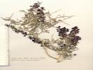 Coll. No. 352, Psorothamnus fremontii var. fremontii Coll. No. 352, Psorothamnus fremontii var. fremontii
|
352 |
Psorothamnus fremontii (A. Gray) Barneby var. fremontii. Fremont's Indigo Bush.
Mesquite Mountains, San Bernardino County, California. On disturbed ground, along Kingston Road, 3.6 mi (5.7 km) northeast of Winters Pass. 35.7299°N, 115.6726°W. WGS 1984. Elev. 990 m. Coll. No. 352, keyed 1 Dec 2012, characters observed: Perennial shrub, armed; Stems never puberulent (f), young stems strigose (f); Leaf mostly compound, 1-pinnate, persistent; Leaflets 5, 9 mm. x 2.5 mm. wide, gland-dotted, terminal continuous (a), lateral continuous when small, jointed when large (f); Calyx 5-6 mm sparsely hairy, lobes ± equal (a), > tube (?); Sepals fused 1/2 length; Flower bilateral; Corolla violet-purple; Banner outside wings; Fruit immature 5 mm. exserting, glands scattered (a), hairy along top and bottom edges and not sides (f). Some characters marked (a) argue for Psorothamnus arborescens while others marked (f) argue for P. fremontii. | ||||||||||||||||||||||||||||||||||||||||||||||||||||||||||||||||||||||||||||||||||||||||||||||||||||||||||||||||||||||||||||||||||||||||||||||||||||||||||||||||||||||||||||||||||||||||||||||||||||||||||||||||||||||||||||||||||||||||||||||||||||||||||||||||||||||||||||||||||||||||||||||||||||||||||||||||||||||||||||||||||||||||||||||||||||||||||||||||||||||||||||||||||||||||||||||||||||||||||||||||||||||||||||||||||||||||||||||||||||||||||||||||||||||||||||||||||||||||||||||||||||||||||||||||||||||||||||||||||||||||||||||||||||||||||||||||||||||||||||||||||||||||||||||||||||||||||||||||||||||||||||||||||||||||||||||||||||||||||||||||||||||||||||
| Approximately mid-canyon on the east side, UTM: 11S 618600 3953000, elevation: 1020 meters. There is a fence line crossing the canyon. I went up on the south side of the road to a small rock shelter. | ||||||||||||||||||||||||||||||||||||||||||||||||||||||||||||||||||||||||||||||||||||||||||||||||||||||||||||||||||||||||||||||||||||||||||||||||||||||||||||||||||||||||||||||||||||||||||||||||||||||||||||||||||||||||||||||||||||||||||||||||||||||||||||||||||||||||||||||||||||||||||||||||||||||||||||||||||||||||||||||||||||||||||||||||||||||||||||||||||||||||||||||||||||||||||||||||||||||||||||||||||||||||||||||||||||||||||||||||||||||||||||||||||||||||||||||||||||||||||||||||||||||||||||||||||||||||||||||||||||||||||||||||||||||||||||||||||||||||||||||||||||||||||||||||||||||||||||||||||||||||||||||||||||||||||||||||||||||||||||||||||||||||||||||
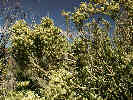 Growth habit of Mortonia utahensis. Growth habit of Mortonia utahensis.
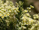 Typical appearance of leaves on Mortonia utahensis Typical appearance of leaves on Mortonia utahensis
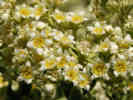 Flowers of Mortonia utahensis. Flowers of Mortonia utahensis.
|
353 | Mortonia utahensis | ||||||||||||||||||||||||||||||||||||||||||||||||||||||||||||||||||||||||||||||||||||||||||||||||||||||||||||||||||||||||||||||||||||||||||||||||||||||||||||||||||||||||||||||||||||||||||||||||||||||||||||||||||||||||||||||||||||||||||||||||||||||||||||||||||||||||||||||||||||||||||||||||||||||||||||||||||||||||||||||||||||||||||||||||||||||||||||||||||||||||||||||||||||||||||||||||||||||||||||||||||||||||||||||||||||||||||||||||||||||||||||||||||||||||||||||||||||||||||||||||||||||||||||||||||||||||||||||||||||||||||||||||||||||||||||||||||||||||||||||||||||||||||||||||||||||||||||||||||||||||||||||||||||||||||||||||||||||||||||||||||||||||||||
|
Other articles:
|
354 |
Cirsium neomexicanum A. Gray. Desert Thistle.
Mesquite Mountains, San Bernardino County, California. Alongside the road, 2.15 mi (3.46 km) northeast of Winters Pass on Kingston Road, near the rock shelter and cattle guard. 35.7176°N, 115.6908°W. WGS 1984. Elev. 1020 m. Coll. No. 354, 20 April 2004, characters observed while keying: Annual or biennial, to 60 cm., Stem, tomentose, ribbed; Leaves, alternate, 40 mm., sessile, not clasping, lanceolate, spiny lobed (not compound), both surfaces wooly; Inflorescence, solitary heads, no flowers with strap-shaped corollas, flowers of 1 kind; Involucre to 25 mm. × 60 mm. wide; Phyllaries, in many series, abaxial face without, or with very small, resinous ridge, outer margins variously minutely decorated (with hairs, spines, and cilia), inner entire, tip spines 8 mm.; Receptacle, simple bristles, 4 mm.; Corolla, tube 13 mm. + throat 7 mm. + lobes 9 mm. | ||||||||||||||||||||||||||||||||||||||||||||||||||||||||||||||||||||||||||||||||||||||||||||||||||||||||||||||||||||||||||||||||||||||||||||||||||||||||||||||||||||||||||||||||||||||||||||||||||||||||||||||||||||||||||||||||||||||||||||||||||||||||||||||||||||||||||||||||||||||||||||||||||||||||||||||||||||||||||||||||||||||||||||||||||||||||||||||||||||||||||||||||||||||||||||||||||||||||||||||||||||||||||||||||||||||||||||||||||||||||||||||||||||||||||||||||||||||||||||||||||||||||||||||||||||||||||||||||||||||||||||||||||||||||||||||||||||||||||||||||||||||||||||||||||||||||||||||||||||||||||||||||||||||||||||||||||||||||||||||||||||||||||||
|
Other articles:
|
355 |
Phacelia vallis-mortae J. W. Voss. Death Valley Phacelia.
Mesquite Mountains, San Bernardino County, California. Alongside Kingston Road, near the rock shelter and cattle guard, 2.2 miles northeast of Winters Pass, and 6.3 miles southwest of the Nevada state boundary. 35.7174°N, 115.6908°W. WGS 1984. Elev. 1020 m. Coll. No. 355, 20 April 2004, characters observed while keying: Annual, to 25 cm., tap-rooted; Stem strongly erect, 0-branched, glandular above middle; Leaves, alternate, petiole 7 mm., blade 22 mm., all deeply lobed to mid-rib, appearing compound, leaflets toothed, except distally; Pedicels in fruit 0.5 mm., stout (not thread-like); Calyx, 5 sepals, 5 mm. × 1 mm. wide, > fruit, elliptic (maybe) or oblanceolate; Corolla blue, deciduous; Style, 7 mm., divided 4.5 mm., exserted; Fruit, 3 mm., ovoid; Ovules, 1 per chamber, 4 per fruit, Seed, 2.5 mm., ovoid, pitted on both sides, ±ridged on adaxial side, but not grooved. | ||||||||||||||||||||||||||||||||||||||||||||||||||||||||||||||||||||||||||||||||||||||||||||||||||||||||||||||||||||||||||||||||||||||||||||||||||||||||||||||||||||||||||||||||||||||||||||||||||||||||||||||||||||||||||||||||||||||||||||||||||||||||||||||||||||||||||||||||||||||||||||||||||||||||||||||||||||||||||||||||||||||||||||||||||||||||||||||||||||||||||||||||||||||||||||||||||||||||||||||||||||||||||||||||||||||||||||||||||||||||||||||||||||||||||||||||||||||||||||||||||||||||||||||||||||||||||||||||||||||||||||||||||||||||||||||||||||||||||||||||||||||||||||||||||||||||||||||||||||||||||||||||||||||||||||||||||||||||||||||||||||||||||||
|
Other articles:
|
356 |
Lycium andersonii A. Gray. Water Jacket.
Mesquite Mountains, San Bernardino County, California. Alongside Kingston Road, near the rock shelter and cattle guard, 2.2 miles northeast of Winters Pass, and 6.3 miles southwest of the Nevada state boundary. 35.7174°N, 115.6908°W. WGS 1984. Elev. 1020 m. Coll. No. 356, 20 Apr 2004, characters observed while keying: Woody perennial shrub, ±glabrous; Stem, branches straight; Leaf, ± linear to slightly obovate, petiole 1.5 mm + blade 5 mm × 1.5 mm wide; Calyx, cup-shaped, in fruit, ≤2 mm; Corolla lobes unknown; Seeds many. | ||||||||||||||||||||||||||||||||||||||||||||||||||||||||||||||||||||||||||||||||||||||||||||||||||||||||||||||||||||||||||||||||||||||||||||||||||||||||||||||||||||||||||||||||||||||||||||||||||||||||||||||||||||||||||||||||||||||||||||||||||||||||||||||||||||||||||||||||||||||||||||||||||||||||||||||||||||||||||||||||||||||||||||||||||||||||||||||||||||||||||||||||||||||||||||||||||||||||||||||||||||||||||||||||||||||||||||||||||||||||||||||||||||||||||||||||||||||||||||||||||||||||||||||||||||||||||||||||||||||||||||||||||||||||||||||||||||||||||||||||||||||||||||||||||||||||||||||||||||||||||||||||||||||||||||||||||||||||||||||||||||||||||||
|
Literature Cited:
Other articles:
|
357 |
|
|
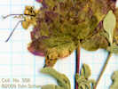 Collection No. 358, Salvia dorrii, Purple Sage Collection No. 358, Salvia dorrii, Purple Sage
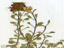 Collection No. 358, Salvia dorrii, Purple Sage Collection No. 358, Salvia dorrii, Purple Sage
358
|
Salvia dorrii
|
|
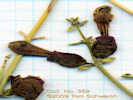 Collection No. 359, Salazaria mexicana, Mexican Bladder Sage Collection No. 359, Salazaria mexicana, Mexican Bladder Sage
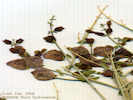 Collection No. 359, Salazaria mexicana, Mexican Bladder Sage Collection No. 359, Salazaria mexicana, Mexican Bladder Sage
359
|
Salazaria mexicana
|
|
Literature Cited:
Other articles:
|
Driving by "The Cross" on Kessler Springs Road, I noticed that a box has been placed over it. | When I later drove by, Sunday, May 22, 2004, the box had been removed. Meanwhile, on June 8, 2004, the Ninth Circuit Court of Appeals affirmed that the cross likely violated the establishment clause. Attempts to transfer the property to private owners have not rendered the case moot because it may take several years to complete the property transfer.
|
|
After a fine dinner of pistacios, carrots, cucumber, and Blue Heron Ale, I walked a bit around the campground looking for plants in bloom. I think (again) this was a good year for some plants.
|
|
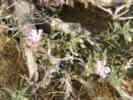 Phlox stansburyi in the Mid Hills Campground. Phlox stansburyi in the Mid Hills Campground.
|
Phlox stansburyi is common, growing out of the Basin Sagebrush (Artemisia tridentata).
|
|
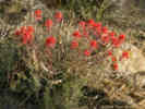 Paintbrush in the Mid Hills Campground Paintbrush in the Mid Hills Campground
|
The Paintbrushes were out.
|
|
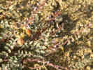 Locoweed in the Mid Hills Campground Locoweed in the Mid Hills Campground
|
There were a couple of huge Astragalus.
|
|
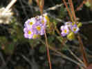 Pretty little Phacelia in the Mid Hills Campground. Pretty little Phacelia in the Mid Hills Campground.
|
This pretty little Phacelia, growing under the Pinyons, was fairly common, but never growing in any large masses.
|
|
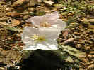 California Evening Primrose in Mid Hills Campground California Evening Primrose in Mid Hills Campground
|
The California Evening Primrose (Oenothera californica ssp. avita) was just beginning to bloom.
|
|
|
| Wednesday, April 21, 2004
|
|
| Thursday, April 22, 2004
|
|
This morning it is cool and breezy again. I left Las Vegas and drove past Goodsprings, and through Sandy to the Mesquite Mountains. There I stopped at the first canyon on the left. This is a limestone canyon, and from the road looks to be somewhat small. The UTM location is 11S 0619370 3954207. The elevation at the mouth of the canyon is 950 m. I walked up the canyon and was surprised to find my self on a bench well up above the floor of the canyon. Walking up this way, I saw many Delphinium and Allionia.
|
|
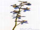 Collection No. 360, Delphinium parishii var. parishii, Parish's larkspur. Collection No. 360, Delphinium parishii var. parishii, Parish's larkspur.
360
|
Delphinium parishii
|
|
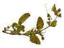 Whole Scan of Collection No. 361, Allionia incarnata L. Whole Scan of Collection No. 361, Allionia incarnata L.
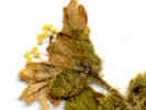 Detail of flower of Collection No. 361 Allionia incarnata L. Detail of flower of Collection No. 361 Allionia incarnata L.
361
|
Allonia incarnata L.
|
|
Literature Cited:
Other articles:
362
|
|
|
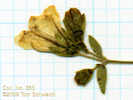 Collection No. 363, Mirabilis laevis var. villosa Collection No. 363, Mirabilis laevis var. villosa
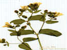 Collection No. 363, Mirabilis laevis var. villosa Collection No. 363, Mirabilis laevis var. villosa
363
|
Mirabilis bigelovii [= M. laevis var. villosa] TAS 19-Feb-05
|
|
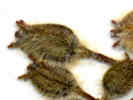 Scan of buds in Camissonia brevipes ssp. brevipes Scan of buds in Camissonia brevipes ssp. brevipes
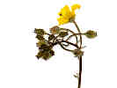 Whole Collection No. 364, Camissonia brevipes ssp. brevipes Whole Collection No. 364, Camissonia brevipes ssp. brevipes
364
|
Camissonia brevipes (A. Gray) Raven ssp. brevipes
|
|
365
|
Krameria erecta
|
|
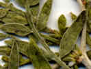 Scan of a portion of Collection No. 366. Scan of a portion of Collection No. 366.
366
|
Unknown
|
|
367
|
Penstemon palmeri
|
|
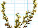 Whole Scan of Collection No. 368 Pectocarya platycarpa Whole Scan of Collection No. 368 Pectocarya platycarpa
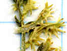 Detail of Collection No. 368 Pectocarya platycarpa Detail of Collection No. 368 Pectocarya platycarpa
368
|
Pectocarya platycarpa (Munz & I. M. Johnst.) Munz & I. M. Johnst. Broad-Fruited Combseed.
|
|
369
|
Plantago
|
|
370
|
Kra lan
|
|
|
Atriplex sp.
|
|
372
|
Arenaria macradenia
|
|
373
|
Salvia mohavensis vegetative matter only, plant not blooming yet.
|
|
Other articles:
|
Photograph taken April 23, 2004. | On the south side of the road, climbing up to some dip-slope limestone outcrops, I saw 4-5 Calochortus flexuosus.
|
Other articles:
|
I walked up to the quartzite outcrop on the south side of the road. On the way back to the car, I collected these two different Atriplexes. Location was 11S 3953350 618750, elevation: 1000 m.
|
|
374
|
Grayia spinosa (Hook.) Moq.
|
|
375
|
Grayia spinosa (Hook.) Moq.
|
|
|
Just below the fence on the south side of the road at 11S 3953250 618500, elevation 1000 m.
|
|
376
|
Salvia dorrii
|
|
377
|
Castelleja chromosa(?)
|
|
378
|
Sphaeralcea ambigua
|
|
379
|
Palafoxes sp.
|
|
|
Above the fence line, with Mortonia.
|
|
Other articles:
380
|
Cryptantha
| Mesquite Mountains, San Bernardino County, California. Alongside the road, 2.15 mi (3.46 km) northeast of Winters Pass on Kingston Road, near the rock shelter and cattle guard, 69 km southwest of Las Vegas, Nevada. 35.7176°N, 115.6908°W. WGS 1984. Elev. 1040 m. Discarded, no nutlets.
|
|
In the side canyon on the cherry stem road, 11S 3952403 617237, elevation 1140 m.
|
|
381
|
Phoradendron on Acacia greggii
|
|
382
|
Nama
|
|
383
|
Mimulus
|
|
|
Unknown
|
|
385
|
Eriogonum
|
|
|
| Friday, May 21, 2004
|
|
Nine and one-half hours from Alameda to Mid Hills including a grocery store and lunch stop in Bakersfield.
|
|
|
| Saturday, May 22, 2004
|
Other articles:
|
This morning was cool and breezy. We set off down Wild horse Canyon and turned in the road to the north face of Wild Horse Mesa. Took Cheryl, Charlene and Jake up to my plots. Along the way we saw many Calochortus kennedyi in bloom. There were also numerous Frasera albomarginata rosettes, much lower than I remember seeing them before, just where the slope wash from the limestone comes down the old road. We saw one plant with many buds and just one flower open, and another plant with many buds. In my plot, there were 53 new rosettes. This number was very much a surprise. I had thought there might have been 10 or 15 new plants, not 53 plants.
|
|
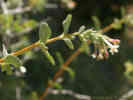 Symphoricarpus longiflorus at Lobo Point. Symphoricarpus longiflorus at Lobo Point.
|
We drove into Lobo Point for lunch. The Fragrant Snowberry (Symphoricarpos longiflorus) was in bloom.
|
|
 Jake contemplates the meaning of life from "Re-Birth Rock." Jake contemplates the meaning of life from "Re-Birth Rock."
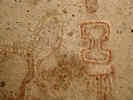 Pictograph at SBr-291 Pictograph at SBr-291
|
After lunch we drove out to Wild Horse Canyon Road and down Wild Horse Canyon. After a couple of miles we pulled over, and then walked the half mile or so to Ceremonial Site.
|
|
Other articles:
Locations:
Hole-in-the-Wall.
|
|
|
|
Back up Black Canyon Road to Mid Hills campground.
|
|
|
| Sunday, May 23, 2004
|
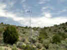 Remote Automated Weather Station (RAWS) in the Mid Hills Remote Automated Weather Station (RAWS) in the Mid Hills
|
Visited the Mid Hills RAWS (Remote Automated Weather Station).
|
|
|
Drove through Jean to Goodsprings.
|
|
|
Tried to drive up on Potosi Mountain, but found a gate closing the road.
|
|
Other articles:
Locations:
Aztec Tank.
|
|
|
|
Then drove into Las Vegas, staying the night at the Holiday Inn Express.
|
|
|
| Monday, May 24, 2004
|
Other articles:
Locations:
Pahrump.
|
Today, we left Las Vegas and returned to NV Highway 160, over Mountain Springs Pass into Pahrump Valley.
|
|
Other articles:
Locations:
Pahrump.
|
Drove through Pahrump, finding it much larger than we expected. Pahrump has experienced some explosive growth recently, to the point of threatening existence of the brothels.
|
|
Other articles:
Locations:
Resting Spring Range.
|
From Pahrump, we turned west on NV Highway 372 headed for Califronia and CA Highway 378.
|
|
Other articles:
Locations:
Chicago Valley.
|
|
|
Other articles:
Locations:
Shoshone.
|
|
|
Other articles:
Locations:
Funeral Mountains.
|
|
|
Other articles:
Locations:
Ash Meadows National Wildlife Refuge.
|
Stopped at the office.
|
|
Locations:
Ash Meadows National Wildlife Refuge.
|
Followed the Crystal Spring boardwalk to Crystal Spring.
|
|
|
Had lunch
|
|
Locations:
Devil's Hole.
|
Drove to Devils Hole.
|
|
Locations:
Devil's Hole.
|
Short walk into the area, around the left or south side is a small boardwalk that lets you see down into Devils Hole.
|
|
Locations:
Ash Meadows National Wildlife Refuge.
|
Drove to Point of Rocks Spring. Short walk to the spring. Picnic table under the mesquite.
|
|
Locations:
Ash Meadows National Wildlife Refuge.
|
Many bright blue pupfish in Point of Rocks Spring.
|
|
|
Left Ash Meadows NWR, and drove to Beatty, turning left to visit Rhyolite.
|
|
Other articles:
Locations:
Rhyolite.
|
|
|
|
Drove up to the depot,
|
|
|
Then returned to Beatty where we stopped for the day at the Motel 6.
|
|
|
| Tuesday, May 25, 2004
|
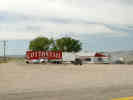 Cottontail Ranch brothel at Lida Junction. Cottontail Ranch brothel at Lida Junction.
|
Drive from Beatty today north on US Highway 95, to the junction with Nevada Highway 268 turning left and west at the Cottontail Ranch.
|
|
Other articles:
Locations:
Magruder Mountain.
|
View of Magruder Mountain and Palmetto Mountain from the east. This photograph was taken from near the intersection of Nevada Highway 266 and Nevada Highway 774, the road to Gold Point. Magruder Mountain in the right center. The range in right center are the Palmetto Mountains. Lida is in the valley between Magruder Mountain and the Palmetto Mountains.
|
|
Other articles:
Locations:
Lida.
|
Stopped a few minutes in Lida. It looks like about half dozen houses are occupied. There is a larger, new house up on the hill to the north of town.
|
|
Other articles:
Locations:
Lida.
|
Later, having returned home and doing some research on the Internet, I learned that the town site of Lida comprises 124 lots all owned by Jack Vogt, a local cattle rancher. The ranch is for sale, with an offering price of $20,000,000.00. Included in the property are the historic town sites of Lida, Pigeon Spring, and Palmetto, as well as 2,882 acres and ten mining claims.
|
|
|
In 2001, Jack Vogt was also involved in a dispute with the BLM about grazing fees, which he apparently stopped paying in 1995. This would be about the time from which several letters indicate that Vogt was the Chairman of the Esmeralda County Public Lands Commission. While the numbers in the newspapers are inconsistent, in late July 2001 the BLM rounded up about 130 head of cattle from Vogts ranch and threatened to sell them at auction. In the meantime, either 49 or 73 were shown to have been sold to another rancher, one Julian Smith. Smith was not a party to the grazing fee dispute, and therefore the cattle were released to him. At the auction for Vogts remaining impounded cattle, there was a verbal protest that, Theyre stolen cattle, and there were no bids. The ultimate fate of the cattle was not indicated in the news reports.
|
|
Other articles:
|
From Lida we continued west over Lida Summit, turning off the main road onto a little dirt that leads south. We stopped at a little clearing at the ecotone between the Pinyon forest, and a patch of Sagebrush.
|
|
Other articles:
|
10:26 AM: 11S 447705 4141735 altitude 2178 m.
|
|
Other articles:
386
|
Eremothera boothii (Douglas) W.L. Wagner & Hoch ssp. intermedia (Munz) W.L. Wagner & Hoch. Booth's Hairy Evening Primrose.
| Magruder Mountain, Esmeralda County, Nevada. West slope of Magruder Mountain, 0.3 mi south of Nevada Highway 266, 6.3 miles by road west of Lida, Nevada. 37.421°N, 117.591°W. WGS 1984. Elev. 2178 m. Between a Pinyon woodland and Sagebrush. Coll. No. 386, keyed 12 Dec 2012, characters observed: Annual, 8-11 cm.; Stem, 1+ mm. dia., decumbent to ascending, tomentose below to thinning above; Stipules absent; Leaves, basal and cauline, rosette present at flowering, much reduced above, oblanceolate, largest 30 mm x 12 mm, margin entire; Sepals 3 mm., opening separately, deciduous after flowering; Hypanthium 3 mm.; Petals 4, 5 mm., white fading pink; Stamens 8; Stigma 1mm., spherical; Fruit, sessile, to 20 mm. x 1.2 mm. wide at base, wider proximally; Seed, 1.5 mm. x 0.5 mm. wide, elliptical, not-winged, glabrous.
|
Other articles:
387
|
Lupinus holmgrenanus C. P. Sm. Holmgren's Lupine.
| Magruder Mountain, Esmeralda County, Nevada. West slope of Magruder Mountain, 0.3 mi south of Nevada Highway 266, 6.3 miles by road west of Lida, Nevada. 37.421°N, 117.591°W. WGS 1984. Elev. 2178 m. Between a Pinyon woodland and Sagebrush. Coll. No. 387, keyed 7 Dec 2012, characters observed: Perennial to 40 cm.; Leaf basal ?, cauline, palmate; Petiole 9-12 cm.; Leaflet 25-45 mm. x 7 mm. wide, equally strigose top and bottom; Inflorescence open (i.e., not crowded), many flowered (18-20+); Bracts persistent; Petiole 6-7 mm.; Calyx strigose 6 mm., spur 0; Banner 8 mm., back glabrous; Wings glabrous; Keel 10 mm., ciliate distal half.
|
Other articles:
388
|
Allium atrorubens Watson var. cristatum (S. Watson) McNeal. Dark Red Onion.
| Magruder Mountain, Esmeralda County, Nevada. West slope of Magruder Mountain, 0.5 km south of Nevada Highway 266, 379 km north of Los Angeles, California. 37.421°N, 117.591°W. Elev. 2178 m. Three seen, two collected, each plant had multiple bulbs and bulblets. Between a Pinyon woodland and Sagebrush. Collection No. 388, 9 August 2012, characters observed while keying: Geophyte, bulblets present, Stem 5 cm., Leaves 1 per stem, Pedicels 11 mm. (> perianth), Perianth parts 9-10 mm., ± equal, entire, pink, darker veins, flat margins, Stamens included, Stigma lobes ± 0.
|
Other articles:
389
|
Gilia, small and multi-colored.
| Gilia inconspicua (Sm.) Sweet. Shy Gilia. Magruder Mountain, Esmeralda County, Nevada. West slope of Magruder Mountain, 0.3 km south of Nevada Highway 266, 5.8 miles by air west southwest of Lida, Esmeralda County, Nevada. 37.4195°N, 117.5899°W. WGS 1984. Elev. 2178 m. Small multicolored Gilia. Between a Pinyon Woodland and Sagebrush. Coll. No. 389, keyed 3 Jan 2013, characters observed: Annual, to 11 cm, from small taproot; Leaves basal and cauline; Basal leaves, to 17 mm., lowest glabrous, those above densely wooly, hairs non-glandular, pinnate lobed, lobes acending, sharp-pointed, not bristled, Cauline leaves, different from basal, not clasping, palmately lobed; Inflorescence cyme, open, not in heads or clusters; Calyx 5 mm., lobes equal, ±= 1/2 corolla tube, margins scarious, tips sharp, not bristled; Corolla funnel-shaped, radial, tube 7 mm + lobes 3 mm = 10 mm x 8 mm dia., tube bluish, throat yellow, lobes bluish (colors have faded); Pedicels varying 0-8 mm.; Style no longer than corolla lobe middle; Fruit 6 mm.; Seeds many, tan or light brown, gelatinous when wet. Basal leaves are a little less wooly and the corolla lobes a little larger than would be expected for Gilia inconspicua.
|
Other articles:
390
|
| Mentzelia albicaulis Hook. White-Stem Blazing Star. Magruder Mountain, Esmeralda County, Nevada. West slope of Magruder Mountain, 5.2 miles west of Lida, Esmeralda County, Nevada on State Highway 266, then 0.8 miles south and west on several unnamed dirt roads. 37.421°N, 117.591°W. WGS 1984. Elev. 2178 m. Yellow flowers, long curved fruit. Between a Pinyon woodland and Sagebrush. Coll. No. 390, 25 May 2004, characters observed: Annual, to 15 cm., Leaves, basal and cauline, deeply pinnately alternately lobed to mid-rib; Bracts, entire, green; Petals, 6 mm. × 2.0-2.5 mm. wide, yellow; Fruit, 20 mm., obconic (Sect. Trachyphytum), curved 30°-80°(130°); Seeds, 4 rows above fruit middle, angular, 1.3 mm. × 0.7 mm. × 0.5 mm., dark tan to black, seed coat cells domed on seed surface edges (seed coat cells flattened away from edges). The two Nevada Mentzelia that are known from this area and not in TJM2, M. candelariae and M. tiehmii, are in Sect. Bartonia, whereas this specimen is in Sect. Trachyphytum. Therefore use of TJM2 key for this Nevada specimen seems reasonable.
|
Other articles:
391
|
Little white Gilia
| Gilia inconspicua (Sm.) Sweet. Shy Gilia. Magruder Mountain, Esmeralda County, Nevada. West slope of Magruder Mountain, 0.3 km south of Nevada Highway 266, 5.8 miles by air west southwest of Lida, Esmeralda County, Nevada. 37.4195°N, 117.5899°W. WGS 1984. Elev. 2178 m. Little white gilia. Between a Pinyon woodland and Sagebrush. Coll. No. 391, keyed 3 Jan 2013, characters observed: Annual, to 9 cm.; Leaves basal and cauline, pinnately lobed, tips acute, not bristly; Basal leaves, non-glandular hairy, lobes 1 mm., widest > 5 mm wide; Cauline leaves, much reduced above, not clasping at base; Inflorescence open, cyme, not in heads or clusters; Pedicels varying, 2-8 mm.; Calyx 3 mm., lobes equal, < tube, margins scarious, not ciliate, not bristle-tipped, barely glandular; Corolla tube 5 mm + lobes 2.5 mm = 7.5 mm x 4.5 mm diameter, described as white when collected, small areas of bluish color noted when dry 8 years later; Style reaching no further than corolla lobe middle; Fruit 4 mm.; Seeds many, > 1 per chamber, greenish light brown, somewhat gelatinous when wet. Collected in the same location, and keys similarly to, my collection #389, Gilia inconspicua (Sm.) Sweet. However, when collected the flowers were described as white, as opposed to multicolor.
|
Other articles:
392
|
Mimulus, very small, magenta with yellow throats.
|
|
Other articles:
|
Phacelia gymnoclada Torr. ex S. Watson. Nakedstem Phacelia.
| Magruder Mountain, Esmeralda County, Nevada. West slope of Magruder Mountain, 0.3 mi south of Nevada Highway 266, 6.3 miles by road west of Lida, Nevada. 37.4209°N, 117.591°W. WGS 1984. Elev. 2178 m. Between a Pinyon woodland and Sagebrush. The one little collection I made was pretty much destroyed by dissection. Coll. No. 393, keyed 18 Jan 2013, characters observed: Small annual to 3 cm., max., short hairy glandular; Leaf 6 mm. x 5 mm wide, elliptical, lobed, petiole 3 mm.; Pedicel 0.7-0.9 mm.; Calyx lobes 5, ± alike, to 4 mm. x 0.7 mm. wide, slightly oblanceolate; Corolla lobes 5, blue, tubes 8 mm. + lobes 3.5 mm. = 11.5 mm. x 8 mm. wide, glabrous inside; Ovary 1.5 mm., distally short-hairy (two placentas easily visualized on dissection); Style 4 mm., included; Stigma 2, short; Stamens 5, different lengths, included; Seeds 8-12 (but too young to be sure).
|
Other articles:
394
|
Lomatium foeniculaceum (Nutt.) J. M. Coult. & Rose ssp. fimbriatum W. L. Theob.
| Magruder Mountain, Esmeralda County, Nevada. West slope of Magruder Mountain, 0.3 mi south of Nevada Highway 266, 6.3 miles by road west of Lida, Nevada. 37.421°N, 117.591°W. WGS 1984. Elev. 2178 m. Between a Pinyon woodland and Sagebrush. Coll. No. 394, keyed 15 Dec 2012, characters observed: Perennial herb from tap root, dry area, no tuber observed within 6 cm. of soil surface, plant to 20 cm., spreading short hairy, not scented; Stem 0; Leaf, dissected, segments many, small (2 mm x 1mm wide), petiole less than or equal blade; Inflorescence a compound umbel, bractlets hairy; Corolla white(-ish?), margin minutely ciliate; Anthers yellow (def. not purple); Fruit to 6 mm., elliptical to round, hairy, not evidently notched at base and tip, ribs at margins expanded as small wings, wings 1/3 body width, thin.
|
Other articles:
395
|
Cryptantha.
|
|
Other articles:
396
|
Chorizanthe brevicornu Torr. var. spathulata (Rydb.) C. L. Hitchc. Brittle Spineflower., only the innermost small white flowers were open. Determination tentative, collection was too immature and too brittle eight years later for a good diagnosis.
| Collection No. 396, 15 August 2012, characters observed while keying: Annual, Stem ocreae absent Leaf basal, petiole 8 mm., blade 19 mm. by 12 mm. wide, Pedicels subtended by 2 free linear bractlets (supposedly transparent but not in my collection), Flower cluster subtended by an involucre of fused bracts, 6-ribbed, tubular, teeth of equal length and without scarious margins, Perianth lobes entire, white, but unable to further dissect flower to complete determination.
|
Other articles:
397
|
“Popcorn” flower, hairy.
| Cryptantha gracilis Osterh. Narrow-Stem Cryptantha. Magruder Mountain, Esmeralda County, Nevada. West slope of Magruder Mountain, 5.2 miles west of Lida, Esmeralda County, Nevada on State Highway 266, then 0.8 miles south and west on several unnamed dirt roads. 37.4209°N, 117.5911°W. WGS 1984. Elev. 2178 m. Popcorn flower, hairy, different than Coll. No. 398 (Cryptantha pterocarya). Nutlets: 1, + 3 abortive. Between a Pinyon woodland and Sagebrush. Coll. No. 397, 25 May 2004, characters observed: Annual, to 13 cm.; Calyx, hairs, ±straight, tip bristles straight (not reflexed); Corolla, limb very small (< 1 mm.); Nutlets, #4, 1 developed, 3 abortive, 2.0 mm. × 0.8 mm. × 0.5 mm., smooth, shiny, scar not raised, adaxially grooved above scar (the groove is closed from ±60-95% of nutlet length), margin sharp-angled.
|
Other articles:
398
|
“Popcorn” flower, different from 397, not hairy, calyx lime green.
| Cryptantha pterocarya (Torr.) Greene var. pterocarya. Wingnut Cryptantha. Magruder Mountain, Esmeralda County, Nevada. West slope of Magruder Mountain, 5.2 miles west of Lida, Esmeralda County, Nevada on State Highway 266, then 0.8 miles south and west on several unnamed dirt roads. 37.421°N, 117.591°W. WGS 1984. Elev. 2178 m. Plant green. Calyx sinus prominent. Four nutlets, hetermorphic, three nutlets with toothed wings. Between a Pinyon woodland and Sagebrush.
|
Other articles:
|
Moved in the road a little further, on the west-facing nose of a small ridge, the Pinyons and the Sagebrush are more mixed at this location. 11S 0447368 4141329 2179 m
|
|
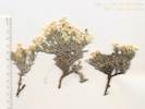 Coll. No. 399, Phlox hoodii var. canescens Coll. No. 399, Phlox hoodii var. canescens
399
|
White phlox.
| Phlox hoodii Richardson ssp. canescens (Torr. & A. Gray) Wherry. Carpet Phlox. Magruder Mountain, Esmeralda County, Nevada. West slope of Magruder Mountain, 5.2 miles west of Lida, Nevada, on Nevada State Route 266, and then 1.1 miles by road southwest. 37.4173°N, 117.5948°W. WGS 1984. Elev. 2179 m. White phlox. Open area with Pinyons and Sagebrush. Coll. No. 399, keyed 4 Jan 2013, characters observed: Perennial, woody, dense, to 6 cm.; Leaves, opposite, 5 mm., lanceolate, entire, sharp-pointed, hairy and with separate sessile granular glands (which can be seen in profile on the abaxial surface of leaves), but the hairs are not glandular; Calyx, lobes equal, 6 mm., few glands on hairs in adaxial tips; Corolla, tube 13 mm + lobes 5 mm = 18 mm, throat slightly constricted; Stamens unequal. The combination of non-glandular hairs and sharp-tipped leaves causes this collection to key poorly by TJM2 or Taylor (2010), but per Welsh (Utah), P. Hoodii appears to be the best compromise.
|
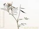 Coll. No. 400, Astragalus casei Coll. No. 400, Astragalus casei
400
|
Astragalus, growing from inside an Artemisia.
| Astragalus casei A. Gray. Case's Milkvetch. Magruder Mountain, Esmeralda County, Nevada. West slope of Magruder Mountain, on a dirt road about 1.5 miles west southwest of Lida Summit. 37.4173°N, 117.5948°W. WGS 1984. Elev. 2179 m. Growing from inside Artemisia. Open area with Pinyons and Sagebrush. Coll. No. 400, keyed 30 Nov 2012, characters observed: Perennial, of Great Basin, 35-40 cm.; Stem erect; Stipule sheathed 0; Leaf hairs simple; Leaflet 15 mm. x 2-2.5 mm. wide, tip obtuse to slightly acuminate, terminal leaflet jointed like lateral leaflets, lateral leaflets not reduced; Inflorescence 8-flowered; Calyx base symmetric; Corolla blue/purple; Keel 12-14 mm.; Fruit 27-43 mm., pendent, 1-chambered, stalk base 0.
|
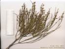 Coll. No. 401, Ephedra viridis Coll. No. 401, Ephedra viridis
401
|
Ephedra viridis Cov. Green Ephedra. | Magruder Mountain, Esmeralda County, Nevada. West slope of Magruder Mountain, approximately 1 km south of Nevada Highway 266, 10 km west southwest of Lida. 37.4173°N, 117.5948°W. WGS 1984. Elev. 2179 m. Female plant. Open area with Pinyons and Sagebrush. Coll. No. 401, 7 June 2012, characters observed while keying: Twig bright green when collected, yellow-green after drying; Leaves 2 per node; Cone bracts 2 per node, fused only at base; Seeds 2.
|
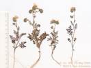 Coll. No. 402, Phacelia distans Coll. No. 402, Phacelia distans
402
|
Phacelia, similar to Coll. No. 415.
| Phacelia distans Benth. Magruder Mountain, Esmeralda County, Nevada. West slope of Magruder Mountain, 5.2 miles by road west of Lida, Nevada, then 1.1 miles by dirt road to the southwest. 37.4173°N, 117.5948°W. WGS 1984. Elev. 2179 m. Open area with Pinyons and Sagebrush. Coll. No. 402, keyed 17 Jan 2013, characters observed: Annual, to 20 cm., from weak taproot and some fibrous roots, cotyledons sometimes persistent; long and short and glandular hairs throughout; Leaves, cauline, sometimes crowded near base, alternate, elliptic, 2° pinnate compound, to 3 (5) cm.; Pedicel 0.8 mm. when fruit young; Calyx lobes 5, entire, ± alike (some slightly larger than others), 5 mm x 1 mm wide; Corolla blue, tube 4 mm + lobes 4 mm = 8 mm., deciduous in fruit; Ovary straight hairy; Style 9 mm., arising from tip of ovary; Stigmas 2, exserted; Stamens 5, exserted 1.5 mm.; Seeds 6 (?), insufficiently developed to count or determine shape accurately.
|
Other articles:
403
|
|
Magruder Mountain, Esmeralda County, Nevada. West slope of Magruder Mountain, approximately 1 km south of Nevada Highway 266, 378 km north of Los Angeles, California. 37.4173°N, 117.5948°W. WGS 1984. Elev. 2179 m. Woody perennial. Open area with Pinyons and Sagebrush. Coll. No. 403, 25 May 2004, characters observed while attempting to key: Perennial, woody at base, to 35 cm., generally short appressed hairy throughout; Leaves, cauline, opposite, sessile or very short petioled, 30 mm. × 5 mm. wide, bases fused around stem, narrowly elliptic, margin entire; Inflorescence, single heads, terminal or axillary, ray flowers immature, reduced, or absent; Phyllaries in 2+ overlapping series, ±equal, 5.5 mm. × 1 mm., lanceolate, entirely green, margins flat, none of the first two series subtending ray flowers; Receptacle convex or conic, paleate; Palea flat, or wrapped around ovary only at base, awned or sharp-pointed; Pappus 0; Corolla, yellow or orange; Anthers, 5, bases rounded but flowers quite immature; Ovary ±thick, not ciliate; Style immature, dilated(?). Flowers are immature. Similarity to Sanvitalia noted when collected, except this is definitely a perennial woody at base, and out of range for Sanvitalia.
|
Other articles:
Locations:
Pigeon Stamp Mill.
|
As the rain began to fall, we drove down, and west, until we came to the road to Tule Spring. Just across the valley is an old mill. On some of the ghost town web sites this is listed as the Pigeon Spring Mill. We pulled in there to eat lunch and wait out the rain. Location on the GPS receiver is 11S 441059N 4141816E, elevation 1951 m
|
|
Other articles:
|
Just beside the car was a grave, with the inscription, Nancy Walker, 1884 1906. Someone has been caring for this grave as the headstone is definitely much newer than 1906, and various objects have been placed on the grave. | When the rain stopped, I collected a bit.
|
Other articles:
404
|
Descurainia sophia (L.) Webb. Tansy Mustard.
| Pigeon Stamp Mill, Esmeralda County, Nevada. On Palmetto Wash between Magruder Mountain and the Sylvania Mountains, 10.2 miles by road west of Lida, Nevada. 37.4213°N, 117.6661°W. WGS 1984. Elev. 1952 m. On flat. Coll. No. 404, keyed 11 Nov 2012, characters observed while keying: Annual, to 30 cm., hairs branched, not scapose; Leaves basal 0, cauline not basally lobed, sagittate, or clasping, 2-pinnate; Inflorescence not bracted; Petals yellow; Ovary, Stigma ±entire (there are clearly two separate segments of the stigma that are receptive, but there is no central cleft between them); Fruit linear, glabrous, not appressed; Septum veined.
|
|
On the slope above the flat where we parked.
|
|
Other articles:
405
|
Eriogonum ovalifolium Nutt. var. ovalifolium. Cushion Buckwheat.
| Pigeon Spring Mill, Esmeralda County, Nevada. On Palmetto Wash between Magruder Mountain and the Sylvania Mountains, 0.3 miles south of Nevada State Route 266 on Palmetto Wash Road, about 10 miles west of Lida, Esmeralda County, Nevada, and 16 miles east of Oasis, Mono County, California. 37.4213°N, 117.6661°W. WGS 1984. Elev. 1952 m. Woody perennial, on slopes. Coll. No. 405, 25 May 2004, characters observed while keying; Perennial cushion plant, not glandular, Scape not jointed, to 15 cm.; Petioles 8 mm.; Leaves ovate 7-11 mm.; Inflorescence head-like; Involucre 2-4 mm.; Flower 3-4 mm., stipe absent; Perianth yellow, outer lobes more than 2x wider than inner.
|
406
|
Penstemon, only one seen, although we would later see this plant many more times, see for example, 414.
|
|
Other articles:
Locations:
Pigeon Stamp Mill.
407
|
Astragalus serenoi (Kuntze) E. Sheld. var. shockleyi (M. E. Jones) Barneby. Shockley's Milk Vetch.
| Pigeon Stamp Mill, Esmeralda County, Nevada. On Palmetto Wash between Magruder Mountain and the Sylvania Mountains, 10.2 miles by road generally west of Lida, Esmeralda County, Nevada. 37.4213°N, 117.6661°W. WGS 1984. Elev. 1952 m. Large plant growing by itself. Coll. No. 407, keyed 21 Nov 2012, characters observed: Perennial of the Great Basin; Stipule sheaths 0; Leaf odd 1-pinnate; Leaflets 7-9, with terminal leaflet, nearly linear 17-24 mm., 1.0-1.5 mm. wide (narrow), terminal joint like that of lateral leaflet, hairs simple, adaxially more densely strigose than abaxially; Raceme 7-9 flowered; Calyx 8 mm., base ±symmetric; Corolla blue/purple; Banner 14 mm.; Fruit stalk-like base 3.5 mm., erect, 15 mm., swollen glabrous, 1(?) chambered at mid-section.
|
|
We drove up the canyon to spring with two large cottonwoods. By GPS, the location is 11S 440976 4141327, elevation 1958 m. I believe this to have been Pigeon Spring.
|
|
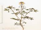 Coll. No. 408, Peritoma lutea Coll. No. 408, Peritoma lutea
408
|
Peritoma lutea (Hook.) Raf. Yellow Bee Plant.
| Pigeon Spring, Esmeralda County, Nevada. At Pigeon Spring, about a half mile south of Nevada State Route 266 and Palmetto Wash, 10.5 miles by road west of Lida, Nevada. 37.4169°N, 117.667°W. WGS 1984. Elev. 1958 m. Growing in disturbed soil, seen also along the highway east of Lida. Coll. No. 408, 25 May 2004, characters observed while keying: Annual very few simple hairs; Roots fleshy 0; Leaves basal 0 or completely withered, cauline compound, leaflets 5; Inflorescence in terminal racemes; Flowers radial; Petals 5 mm., yellow; Stamens 6; Ovary obovate or oblanceolate; Fruit not segmented, receptacle (pedicel) in fruit 8 mm.; Seeds 5.
|
Other articles:
Locations:
Pigeon Spring, 2 km South.
|
|
|
Other articles:
409
|
Ranunculus cymbalaria Pursh. Alkali Buttercup.
| Pigeon Spring, Esmeralda County, Nevada. Near an unnamed mine south of Pigeon Spring, on Palmetto Wash Road 1.4 miles south of Nevada Highway 266, 11.4 miles by road generally west of Lida, Esmeralda County, Nevada. 37.4067°N, 117.6619°W. WGS 1984. Elev. 1992 m. Coll. No. 409, 25 May 2004, characters observed while keying: Perennial herb; Leaves basal, simple (i.e., not compound); Sepal spurs absent; Flower radial; Perianth in 2 whorls; Petals 4+; Anthers yellow; Pistils many; Ovules 1 per ovary; Fruit body 7-9 mm.
|
Other articles:
410
|
Potentilla biennis Greene. Biennial Cinquefoil.
| Pigeon Spring, Esmeralda County, Nevada. In a mining area 0.8 mile south of Pigeon Spring, 1.4 miles south of Nevada Highway 266, and a total of 11.4 miles by road generally west of Lida, Esmeralda County, Nevada. 37.4067°N, 117.6619°W. WGS 1984. Elev. 1992 m. Coll. No. 410, keyed 12 Nov 2012, characters observed: Annual or biennial herb; Stem base hairs moderate, glandular; Leaf ternately compound; Leaflets 3, margins flat; Inflorescence cyme; Stamens many; Style 0.7 mm., widest at base, tapered, warty; Achene 0.7 mm, smooth.
|
Other articles:
411
|
Galium multiflorum Kellogg. Many-Flower Bedstraw.
| Pigeon Spring, Esmeralda County, Nevada. In a mining area 0.8 mile south of Pigeon Spring, 1.4 miles south of Nevada Highway 266, and a total of 11.4 miles by road generally west of Lida, Esmeralda County, Nevada. 37.4067°N, 117.6619°W. WGS 1984. Elev. 1992 m. Hill slope under Pinyons. Coll. No. 411, 25 May 2004, characters observed while keying: Perennial herb or subshrub, woody base, to 25 cm.; Stem, decumbent to ascending, glabrous; Leaves, in whorls of 4, 7-8 mm. × 4.5 mm. wide, ±equal (??), elliptic, margin entire, tip acuminate; Inflorescence, many-flowered, terminal; Flowers, at least some bisexual (??); Corolla, 4-lobed; Fruit, 5.5 mm. wide including hairs, hairs to 2 mm. long, straight.
|
412
|
Streptanthus cordatus Nutt. var. cordatus. Heartleaf Twistflower.
| Pigeon Spring, Esmeralda County, Nevada. In a mining area 0.8 mile south of Pigeon Spring, 1.4 miles south of Nevada Highway 266, and a total of 11.4 miles by road generally west of Lida, Esmeralda County, Nevada. 37.4067°N, 117.6619°W. WGS 1984. Elev. 1992 m. Same as Coll. No. 417. North-facing hill slope.
|
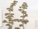 Coll. No. 413, Ribes velutinum Coll. No. 413, Ribes velutinum
413
|
Ribes velutinum E. Greene. Desert Gooseberry.
| Pigeon Spring, Esmeralda County, Nevada. 0.8 miles south of Pigeon Spring, 1.4 miles south of Nevada State Route 266, and 11.4 miles by road generally west of Lida, Esmeralda County, Nevada. 37.4067°N, 117.6619°W. WGS 1984. Elev. 1992 m. North-facing hill slope. Coll. No. 413, keyed 11 Nov 2012, characters observed: Perennial shrub; Stem nodal spines present, internode bristles 0; Inflorescence 1-flowered; Sepals, Hypanthium, and Anthers not visible; Ovary hairs glandular.
|
Other articles:
414
|
Penstemon, in wash.
|
|
Letters:
Wednesday, November 13, 2013.
415
|
| Phacelia distans Benth. Pigeon Spring, Esmeralda County, Nevada. In a mining area 0.8 miles south of Pigeon Spring, about 11.4 miles by road generally west of Lida, Esmeralda County, Nevada. 37.4067°N, 117.6619°W. WGS 1984. Elev. 1992 m. In the shade of and debris from Pinyon. Coll. No. 415, keyed 15 Jan 2013, characters observed: Annual, to 20 cm., green, photosynthetic, growing on steep colluvial slopes among Pinyons; Stem, sparsely straight-hairy and glandular throughout; Leaves, cauline, ± alternate, deeply pinnately lobed; Pedicels, stout, short glandular-hairy; Calyx, lobes 5, 4.5 mm. x 1 mm. wide, ± alike, short hairy, sinus appendages 0; Corolla, tube 6 mm. + lobe 2 mm., blue, deciduous; Ovary, entire, straight hairy; Style, 1, 8.5 mm., arising from tip of ovary, exserted; Stigma, 2; Stamens, 5, 9.5 mm., equal, exserted; Fruit, (young) 2 mm. << sepals (4.5 mm.), stiff straight hairy; Seeds, 4, quarter-moon shape, 1.5 mm., adaxial surface with central ridge separating 2 longitudinal grooves. Calyx lobes are too narrow and fruit too hairy to fit into P. crenulata.
|
416
|
Cryptantha, large yellow.
| Cryptantha confertiflora (Greene) Payson. Basin Yellow Cryptantha. Pigeon Spring, 2 km South, Esmeralda County, Nevada. In a mining area about 2 miles south of Pigeon Spring, about 11.5 miles generally west of Lida, Esmeralda County, Nevada, by way of NV State Highway 266, and an unnamed dirt road. 37.4067°N, 117.6619°W. WGS 1984. Elev. 1992 m. Large yellow flowers. North-facing hill slope. Also collected here: Streptanthus cordatus, Phacelia distans, Ribes velutinum, Penstemon speciosus, Ranunculus cymbalaria, Potentilla biennis, and Galium multiflorum. Coll. No. 416, 25 May 2004, characters observed: Perennial, to 35 cm., taller than wide; Leaves, (appearing) basal and cauline; Bracts 0; Corolla, yellow, tube > calyx; Style, 11 mm., unable to confirm heterostyly across three specimens; Nutlets, #4, immature.
|
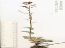 Coll. No. 417, Streptanthus cordatus var. cordatus Coll. No. 417, Streptanthus cordatus var. cordatus
417
|
Streptanthus cordatus Nutt. var. cordatus. Heartleaf Twistflower.
| Pigeon Spring, Mine 2 km South, Esmeralda County, Nevada. Mine south of Pigeon Spring 37.4067°N, 117.6619°W. WGS 1984. Elev. 1992 m. North-facing hill slope. Coll. No. 417, keyed 8 Nov 2012, characters observed while keying: Perennial hairs 0, glabrous, not scapose; Leaves basal, petiole winged, margin dentate, cauline clasping, distal smaller; Inflorescence raceme, not bracted, terminal sterile cluster 0; Stamens 6, in 3 pairs of unequal length, not exserted; Fruit flattened, ascending.
|
|
We turned around and drove over Lida Summit to US Highway 95.
|
|
Other articles:
Locations:
Goldfield.
|
|
|
Other articles:
Locations:
Goldfield.
|
|
|
Other articles:
Locations:
Goldfield.
|
|
|
|
Total time to drive from Pigeon Springs at the west end of Magruder Mountain to Tonopah was about an hour and a half, including a 15 minute stop in Goldfield.
|
|
|
In Tonopah we stayed at the Hi-Desert Best Western Inn, and had dinner at El Marques Mexican Restaurant.
|
|
|
| Wednesday, May 26, 2004
|
|
We left Tonopah after having the continental breakfast at the Hi-Desert Best Western Inn and getting gas and ice at the Giggle Springs gas stations.
|
|
Other articles:
Locations:
White Mountains.
White Mountains.
|
From Tonopah, US Highway 95 goes west. As we rounded a corner we got a good view of the White Mountains in the distance.
|
|
Other articles:
|
From US Highway 95, we drove south on Nevada Highway 265. The Crater, shown on many maps is a cinder cone right beside the highway. | To the northeast of The Crater are some lava-capped sediments that appear on the map as "The Monocline."
|
Literature Cited:
Other articles:
Locations: Mineral Ridge.
|
|
|
Literature Cited:
Other articles:
Locations: Silver Peak.
|
|
|
Literature Cited:
Other articles:
Locations: Silver Peak.
|
|
|
Other articles:
Locations:
Red Mountain.
Silver Peak Range.
|
|
|
Other articles:
Locations:
Clayton Valley Dunes.
|
|
|
Other articles:
Locations:
Coyote Summit.
|
There is a small road heading south where we stopped to look at plants on the ridge top. The locations here, by GPS, is 11S 433436 4181184, elevation: 2257 m.
|
|
Other articles:
418
|
|
Coyote Summit, Esmeralda County, Nevada. Silver Peak Range, at Coyote Summit, 0.3 miles south of Coyote Road, 7.7 miles by road west of Silver Peak, Esmeralda County, Nevada. 37.7756°N, 117.7559°W. WGS 1984. Elev. 2257 m. Coll. No. 418, keyed 29 Nov 2012, characters observed: Perennial subshrub to 15 cm., Great Basin; Crown at surface; Stipule 2-3 mm., sheaths 0; Leaf hairs simple, dense; Leaflet 6-8 mm., 2-2.5 mm. wide, not spine-tipped, lateral leaflets not reduced, terminal leaflet jointed to midrib, joint like that of lateral leaflets; Inflorescence raceme, flowers 15-25, not head-like; Peduncles in 1s; Calyx 4 mm., asymmetric, pedicel attached below middle, upper side not pouched; Corolla blue-purple; Fruit cluster 4 cm., stalk 1.5 mm., pod glabrous, erect, 2-chambered, beak straight;
|
Other articles:
419
|
|
Astragalus lentiginosus Hook. Var. fremontii (A. Gray) S. Watson. Fremont's Milkvetch. Coyote Summit, Esmeralda County, Nevada. Silver Peak Range, at Coyote Summit, 0.3 miles south of Coyote Road, 7.7 miles by road west of Silver Peak, Esmeralda County, Nevada. 37.7756°N, 117.7559°W. WGS 1984. Elev. 2257 m. Coll. No. 419, keyed 29 Nov 2012, characters observed: Perennial of Great Basin, to 20 cm.; Inflorescence raceme, 1 per axil, 8-10 flowered; Calyx 4 mm. x 3 mm. dia., lobes 1 mm., base somewhat asymmetric, upper side not pouched; Stipules to 4 mm., sheath 0; Leaf sparsely hairy, hairs simple; Leaflets 18-21, spaced, terminal leaflet jointed to midrib, lateral leaflets not reduced; Fruit 15 mm., erect, glabrous, 2-chambered.
|
Other articles:
420
|
Draba
|
|
Other articles:
421
|
Lappula redowskii (Hornem.) Greene var. cupulata (A. Gray) M. E. Jones. Crowned Stickseed.
| Coyote Summit, Esmeralda County, Nevada. Silver Peak Range, at Coyote Summit, 0.3 miles south of Coyote Road, 7.7 miles by road west of Silver Peak, Esmeralda County, Nevada. 37.7756°N, 117.7559°E. WGS 1984. Elev. 2257 m. Coll. No. 421, 26 May 2004, characters observed while keying: Annual, to 15 cm., tap-rooted, hairy; Stem branched at base, ascending; Inflorescence racemose; Perianth in 2 or more whorls; Calyx (should be bilateral but unable to see on dried specimens), < nutlets; Receptacle conic, tapered, ±=nutlet; Flowers bisexual, parts 5, radial; Petals fused into a tube; Stamens, 5, fertile; Ovary 1, breaking apart into nutlets; Pistils 1; Style simple, stigma 1, persistent, attached to receptacle; Nutlets, 4, basal and cauline nutlets similarly ornamented, mature ±erect, generally straight, scar lateral, margins dentate or prickles, in single rows, wider at base, fused to form crown, barbed.
|
Other articles:
422
|
Castilleja, red in color, but these seem somewhat short in stature, collected from five different plants, but all were growing from inside an Artemisia tridentata.
| Castilleja chromosa Nelson. Desert Indian Paintbrush. Coyote Summit, Esmeralda County, Nevada. Silver Peak Range, 0.3 mi south of Coyote Road at Coyote Summit, 7.7 road miles west of the town of Silver Peak, Nevada. 37.7756°N, 117.7558°W. WGS 1984. Elev. 2257 m. Growing out of Artemisia tridentata. Coll. No. 422, 26 May 2004, characters observed while keying: Perennial subshrub, growing out of Artemisia tridentata, to 27 cm.; Hairs simple throughout; Leaves alternate, sessile, 30 mm., 3- to 5-lobed, not fleshy, short simple hairy; Inflorescence reddish, not glandular; Bract, 17 mm., 3-lobed; Calyx, 17 mm., divided equally 4 mm. (24%); Corolla, tube 10 mm. + beak 10 mm. = 20 mm., lower lip small teeth, beak greenish yellow above and reddish below.
|
Other articles:
423
|
Elymus multisetus (J. G. Sm.) Burtt Davy. Big Squirreltail. | Coyote Summit, Esmeralda County, Nevada. Silver Peak Range, 0.3 mi south of Coyote Road at Coyote Summit, 7.7 road miles west of the town of Silver Peak, Nevada. 37.7756°N, 117.7559°W. WGS 1984. Elev. 2257 m. Coll. No. 423, 7 June 2012, characters observed while keying: Perennial; Internodes hollow; Leaf blade differentiated from sheath; Sheath open; Ligule membraneous; Auricles small; Inflorescence to 7 cm.; Disarticulation along the inflorescence axis; Spikelets 2 per node; Florets 2-4 per spikelet; Glumes divided near base into 3 awn-like segments, short hairy; Lemma 3-veined, 1 awn; Stamens 3.
|
|
We traveled west one mile west of Coyote Pass and stopped again to look at plants, at location: 11S 432769N 4182568E, elevation: 2169 m.
|
|
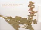 Coll. No. 424, Sphaeralcea ambigua Coll. No. 424, Sphaeralcea ambigua
424
|
Sphaeralcea ambigua A. Gray. Apricot Mallow.
| Silver Peak Range, Esmeralda County, Nevada. One mile west of Coyote Summit, 8.6 miles by road west of Silver Peak, Esmeralda County, Nevada. 37.788°N, 117.7636°W. WGS 1984. Elev. 2169 m. Coll. No. 424, keyed 8 Dec 2012, characters observed: Perennial, to 50 cm.; Hairs stellate; Leaves widely lanceolate, palmately veined, lobed but not deeply divided; Inflorescence panicle, dense in bud; Flower color apricot, fading to pink.
|
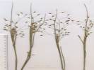 Coll. No. 425, Coll. No. 425,
425
|
Stipa hymenoides Roem. & Schult. Indian Rice Grass. | Coyote Summit, Esmeralda County, Nevada. Silver Peak Range, 1 mile west of Coyote Summit, 8.6 miles by road west of the town of Silver Peak, 212 km northeast of Fresno, California. 37.788°N, 117.7636°W. Elev. 2169 m. Coll. No. 425, 8 June 2012, characters observed while keying: Perennial, mid-sized, to 40 cm.; Internodes not swollen at base, filled with pith; Leaf blade and sheath differentiated, base not woody; Ligule membraneous; Inflorescence well developed, exceeds leaves; Spikelets not enclosed in bur-like involucre or subtended by bristles; Florets not modified into bulblets, 1 per spikelet, 6-7 mm.; Glume short hairy; Lemma hairy, overlapping in part, hardened at maturity, Awn 4 mm., decidiuous.
|
|
Heading further down the canyon, at a narrow spot, there was a spring on the north side of the road. 11S 428004 4183617 1977 m
|
|
Other articles:
426
|
Mimulus guttatus DC. Seep Monkeyflower.
| Silver Peak Range, Esmeralda County, Nevada. At a roadside spring in unnamed canyon, 1.5 mi (2.4 km) east of Cave Spring and 3.8 mi (6.0 km) west of Coyote Summit, south flank of Rhyolite Ridge. 37.7971°N, 117.8178°W. WGS 1984. Elev. 1977 m. Coll. No. 426, 26 May 2004, characters observed while keying: Perennial (?) with both fibrous roots and filiform rhizomes; Stem, erect; Leaves, proximal, petioled 30 mm. + ovate blade 40 mm. × 33 mm. wide, petiole bases fused (excludes M. tilingii), distal leaves sessile to clasping; Pedicel, in fl., 24 mm., > calyx; Calyx, in fl., 10 mm., in fr, unknown; Corolla, yellow, in fl., tube 12 mm. + lobes 5 mm. Characters consistent with Erythranthe guttata (Fischer ex DC.) Nesom.
|
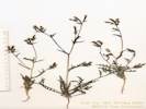 Coll. No. 427, Mentzelia albicaulis Coll. No. 427, Mentzelia albicaulis
427
|
Mentzelia albicaulis Hook. White-Stem Blazing Star.
| Silver Peak Range, Esmeralda County, Nevada. At spring between Cave Spring and Coyote Summit, south flank of Rhyolite Ridge, 10.8 miles by road east southeast of The Crossing, Esmeralda County, and 11.8 miles by road west of Silver Peak, Esmeralda County, Nevada. 37.7971°N, 117.8178°W. WGS 1984. Elev. 1977 m. Coll. No. 427, keyed 14 Jan 2013, characters observed: Annual, 20 cm., taproot; Bract lanceolate, 6 mm., entire, green; Corolla petals free, 5 mm.; Fruit cylindric-obconic, 15 mm. x 2.5 (4.0) mm. wide; Seeds in multiple rows above mid-fruit, dark brown in age, seed coat cells domed.
|
Other articles:
|
|
|
|
Still further down the canyon, we stopped to collect the Argemone at 11S 423254N 4186272E.
|
|
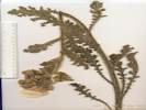 Coll. No. 428, Argemone munita ssp. rotundata Coll. No. 428, Argemone munita ssp. rotundata
428
|
Argemone munita Durand & Hilg. ssp. rotundata (Rydb.) G. B. Ownbey. Flatbud Prickly Poppy.
| Collection No. 428, 12 Oct 2012, characters observed while keying: Annual or biennial; Stem purplish, closely prickly, longest prickles 5 mm; Leaves generally cauline, distal blades not clasping, dissected, prickly on veins, and somewhat between veins; Flower radial; Petals white; Capsule prickles simple, < 5 mm. (Keyed to subspecies per Flora of North America.)
|
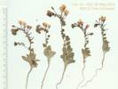 Coll. No. 429, Camissonia pubens Coll. No. 429, Camissonia pubens
429
|
Camissonia pubens (S. Watson) P. H. Raven. Hairy Suncup.
| Silver Peak Range, Esmeralda County, Nevada. Approximately 7.1 miles by road southeast of The Crossing, and 2.3 miles by road northwest of Cave Spring, 39 miles by air southwest of Tonopah, Nevada. 37.8206°N, 117.872°W. WGS 1984. Elev. 1750 m. Coll. No. 429, 26 May 2004, characters observed: Annual, to 11 mm.; Stem 1.5 mm. dia., spreading hairy proximally, glandular hairs throughout; Stipules absent; Leaves basal and cauline, largest 15 mm. x 6 mm. wide, oblanceolate, entire, margins wavy, cauline leaves reduced, Inflorescence from distal nodes, Sepals 3.5 mm., all separating when flower opens, reflexed, deciduous after flowering; Hypanthium 4mm.; Petals 4 mm., yellow fading red, not spotted; Stigma spherical, surrounded by anthers; Fruit sessile, 14 mm. x 1 mm. wider proximally, wavy; Seeds, 1.5 mm., glabrous, convex one side, concave other side, no wing, no club-shaped hairs (therefore not Chylismiella).
|
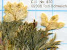 Collection No. 430, Langloisia setosissima var. setosissima Collection No. 430, Langloisia setosissima var. setosissima
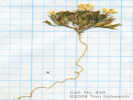 Collection No. 430, Langloisia setosissima var. setosissima Collection No. 430, Langloisia setosissima var. setosissima
430
|
Langloisia
|
|
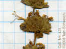 Collection No. 431, Salvia dorrii ssp. dorrii Collection No. 431, Salvia dorrii ssp. dorrii
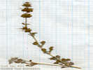 Collection No. 431, Salvia dorrii ssp. dorrii Collection No. 431, Salvia dorrii ssp. dorrii
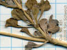 Collection No. 431, Salvia dorrii ssp. dorrii Collection No. 431, Salvia dorrii ssp. dorrii
431
|
Salvia dorrii ssp. dorrii (?)
|
|
Other articles:
Locations:
Cave Spring.
Silver Peak Range.
|
At the mouth of the canyon, we stopped at a corral and line shack for lunch.
|
|
Literature Cited:
Other articles:
Locations: Rhyolite Ridge.
|
|
|
Other articles:
Locations:
White Mountains.
|
The drive from here to The Crossing was uneventful. The Crossing itself is an elevated portion of the road, crossing a small stream. We did not stop at The Crossing, but it seemed that the stream was flowing to the northeast. The topography in this area is a little confused, with an approximate high point at The Crossing with lower elevations to the northeast and southwest.
|
|
Literature Cited:
Other articles:
Locations: Fish Lake Hot Well.
|
| Fish Lake Hot WellJust past (west of) The Crossing is a hot spring. It was surrounded by many signs warning about dire consequences that might result if the vandalism and harassment of the wildlife continues.
|
Other articles:
Locations:
Piper Peak.
Silver Peak Range.
|
|
|
Literature Cited:
Locations:
The Sump.
|
From The Crossing we continued west to Nevada 264, turning north to its junction with Nevada 773. Just past that junction we turned right (southeast) on a small road to The Sump. The road is easy except for a 4-foot drop into the wash. The drive up the wash is an easy mile and a half, where the road ends against the upturned lake beds. | Frank DeCourten in The Broken Land: Adventures in Great Basin Geology, waxes poetic about a night spent at the Sump with his students. It's a place of clear skies and majestic views in addition to the many fossils in the mid-Cenozoic graveyard.
|
Other articles:
Locations:
The Sump.
|
We walked around a bit. The basin looked like it could have formed in the axis of a syncline, but the south limb was sometimes hard to visualize. There was also some strike-slip faulting parallel to the axis of the syncline that was filled with a very dark green fault gouge.
|
|
Other articles:
Locations:
Fish Lake Valley.
|
From The Sump we returned to the highways and then headed northwest on NV Highway 264. We jogged west on US Highway 6, and then north on Nevada Highway 380.
|
|
|
I stopped for a photo at Belleville, which for a time was a mill town for Candelaria, only to learn later that I had confused Belleville with Belmont.
|
|
|
Further on NV Highway 380, we returned again to US Highway 95, where after passing through Mina and Luning, until we came to Hawthorne, where we stopped for the night.
|
|
|
| Mineral County, Nevada
|
Literature Cited:
Locations: Hawthorne.
|
"As Aurora declined, and Hawthorne grew, the county seat of Esmeralda County was moved to Hawthorne and a court house built. In 1900 the Southern Pacific Railroad, purchased the Carson and Colorado, realigning the road bed for a more direct route from Thorne toward the rich mines at Tonopah and Goldfield, bypassing Hawthorne.
|
|
|
The economic slump in Hawthorne resulted in the county seat being moved to Goldfield in southern Esmeralda County. During 1905-1907, mining booms at Lucky Boy, Rawhide, and Dutch Creek brought prosperity back to Hawthorne and a demand for the return of the county seat. Senator Fred Balzar, a native of Hawthorne, proposed dividing Esmeralda, creating "Mineral County in 1911 from the western half of Esmeralda: Balzar later became governor of Nevada.
|
|
|
"Mineral County is appropriately named as gold, silver, copper, mercury, iron, borax, limestone, gypsum, and uranium have been discovered in the county over the years.
|
|
|
"The population of Hawthorne increased to 680 soon after the federal government established the Naval Ammunition Depot on 400 sq. miles surrounding Hawthorne, circa 1927-1929. Hawthorne grew at an astounding rate as the N.A.D. expanded to meet demands of World War II. Civilians, military personnel, and townspeople mushroomed the population to 14,000 by 1944. The federal government built the community of Babbitt, to accommodate the civilian civil service workers, and two-story barracks buildings to house 2,000 sailors. Both areas have been demolished or relocated.
|
|
|
"The past is reflected in the museum. Most of our special collections are donations from present or former residents of our towns of Hawthorne, Luning, and Mina."
|
|
|
| Thursday, May 27, 2004
|
Other articles:
Locations:
Walker Lake.
|
|
|
|
As we passed by Schurz, it looks like a nice town.
|
|
Other articles:
Locations:
Yerington.
|
|
|
|
South of Yerington, I took these photographs showing the full irrigation ditch next to the East Walker River. This is the fork of the river that comes down from Bridgeport.
|
|
Other articles:
|
| The Alameda house in 2004.
|
|
| Saturday July 31, 2004
|
Other articles:
Locations:
Lake Tahoe.
|
Drove from Alameda over US Hwy 50, to Myers, arriving there in about 3 ½ hours.
|
|
Other articles:
Locations:
Hope Valley.
|
From Myers I drove south on CA Hwy 89 over Luther Pass into Hope Valley.
|
|
|
After a slight jog on CA Hwy 88 to the east, I turned south again on CA Hwy 89.
|
|
|
Through Markleville to the junction with CA Hwy 4, I followed CA Hwy 89 east toward Monitor Pass.
|
|
|
I stopped briefly at Heenan Lake. This is where the DFG keeps the brood-stock for for Lahontan Cutthroat trout. Barb-less fishing is allowed for a brief period in the Fall. There are no facilities at Heenan Lake, and you must walk a short way to the lake from the parking lot.
|
|
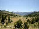 Sagehen Flat and Heenan Lake, looking south. Sagehen Flat and Heenan Lake, looking south.
|
From Heenan Lake I continued a short way east on Hwy 89 to Leviathan Mine Road. Turning off here I continued 11.8 km over a small pass and down a canyon to the locked gate at the Leviathan Mine.
|
|
Locations:
Leviathan Mine.
|
Leviathan Mine Road skirts the mine to the east, climbing up to a ridge and then dropping back down into the canyon on the north side of the mine. I didnt go all the way, stopping to take photos where there was a good view of the mine, and then returning the way I came.
|
|
|
I turned northwest on a road marked Morningstar Road bound for Haypress Flat. However, back at home, the DeLorme TopoUSA shows this as Loop Road.
|
|
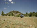 Lunch stop on Loop Road (Morningstar Road) near Monitor Pass. Lunch stop on Loop Road (Morningstar Road) near Monitor Pass.
|
I continued on Loop Road 3.0 km to a small pass, where I stopped for lunch. While eating lunch, I noticed several small flowers, and collected at 11S 266601 4286646, elevation 2453 m.
|
|
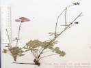 Coll. No. 432 Sidalcea asperella Coll. No. 432 Sidalcea asperella
432
|
Sidalcea asperella Greene. Dwarf Checker Bloom.
| Haypress Flat, Alpine County, California. The southeasternmost edge of Haypress Flat, on Loope Canyon Road, also known as Morning Star Road, 3.7 air miles northwest of Monitor Pass, and 5.3 air miles east of Markleville, California. 38.6977°N, 119.6838°W. WGS 1984. Elev. 2453 m. Coll. No. 432, keyed 31 Jul 2004, characters observed; Perennial to 25 cm., rhizomed, caudex present, few stellate hairs; Stem erect; Leaves basal and cauline, reduced above, round in outline, deeply lobed; Inflorescence open (not dense); Involucel absent (=bractlets 0); Flowers few, 30 mm wide; Petal 16 mm x 10 mm wide, oblanceolate; Anthers near top of filament tube, in multiple (2?) series; Stigmas linear on inside of style branches; Fruit in multiple segments (6+), segments glabrous, coarsely net veined, beak minute (0.2 mm).
|
Other articles:
433
|
Eremogone kingii (S. Watson) Ikonn. var. glabrescens (S. Watson) Dorn. King's Sandwort.
| Haypress Flat, Alpine County, California. The southeasternmost edge of Haypress Flat, on Loope Canyon Road, also known as Morning Star Road, 3.7 air miles northwest of Monitor Pass, and 5.3 air miles east of Markleville, CA. 38.6977°N, 119.6838°W. WGS 1984. Elev. 2453 m. Coll. No. 433, 31 Jul 2004, characters observed while keying: Perennial; Stem 8-9 cm.; Stipules 0; Leaves 12-20 mm., spine-tipped; Inflorescence not umbel-like; Sepals free, 5 mm., acute; Petals entire; Fruit a capsule.
|
|
From here I returned on Loop Road 2 km to a small meadow, with some cows. The location was 11S 268319 4286090, 2320 m.
|
|
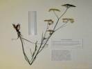 Coll. No. 434, Perideridia parishii ssp. latifolia Coll. No. 434, Perideridia parishii ssp. latifolia
434
|
Carrot Family. After pulling several stems, I got a little curious as to what was underneath. It took a bit of digging to cut the roots and pull a plug of soil out, and then separate the root of this plant from roots of the other meadow plants.
| Perideridia parishii (J. M. Coult. & Rose) A. Nelson & J. F. Macbr. Ssp. latifolia (A. Gray) Chuang & Constance. Parish's Yampah. Monitor Pass, Alpine County, California. On Loope Canyon Road, also known as Morning Star Road, 2.6 miles by air northwest of Monitor Pass, and 6.3 miles by air east of Markleville, CA. 37.421°N, 117.591°W. WGS 1984. Elev. 2320 m. Coll. No. 434, keyed 16 Dec 2012, characters observed: Perennial herb, to 60 cm., glabrous, in small moist meadow; Tuber fusiform, 4 cm x 8 mm dia., no rhizome; Stem green; Leaves 2° ternate, 2 pair 1° leaflets, + terminal leaflet; Inflorescence compound umbel, convex distally; Bracts 0-2 Rays 14-17, in fruit unequal (p); Bractlets 3 mm < pedicels 5 mm (p); Calyx lobes small 0.7 mm, lance-shaped, not a persistent crown on fruit; Fruit 2 mm., not compressed, central axis an apparent structure, ribs prominent but not winged, oily but unable to visualize and count oil tubes. Characters marked (p) are more like ssp. parishii.
|
|
I returned to the car, continued back to Leviathan Road, then turn back southbound for CA Hwy 89.
|
|
|
On the western exposed slope, were some buckwheats. At other locations, these were past their peak bloom and I did not collect them. Here, however, they were at their peak. Tomorrow, I will see many of these along to road over Ebbets Pass.
|
|
Other articles:
435
|
Eriogonum, with Purshia, Artemisia, Cercocarpus, and Pinyon.
|
|
Other articles:
436
|
Monardella odoratissima Benth. ssp. glauca (Greene) Epling. Pale Monardella.
| Monitor Pass, Alpine County, California. On Leviathan Mine Road near the head of Goskey Canyon, 1 mile north of California Highway 89, 3.7 km west of Monitor Pass, and 10.3 km east of Markleville, CA. 38.6814°N, 119.6633°W. WGS 1984. Elev. 2346 m. Coll. No. 436, 31 July 2013, characters observed while keying: Annual/perennial unknown, but assumed to be a herbaceous perennial or subshrub, to 50 cm.; Stem, hairs short, sparse; Leaves, opposite, ovate, 35 mm. × 18 wide mid-cauline, abaxial veins short- hairy, margins serrate and short-hairy; Calyx, radial, sepals fused 5 mm + lobes 3 mm = 8 mm., tips acute; Stamens 2, staminodes 2; Anthers, sacs fertile 2, attached to filament side by side.
|
Other articles:
Locations:
Monitor Pass.
|
From here I returned to CA Hwy 89 and continued east to Monitor Pass.
|
|
|
Here I turned north on a small road just west of Big Springs Road. There were many, many Paintbrush growing from the Big Sagebrush. Crossed the valley, including a crossing of the dry Mountaineer Creek, and continued on Big Springs Road to a small saddle. Determined that I did not want to continue in this direction, so I turned around and stopped at Big Spring.
|
|
|
Stopped at Big Spring, which is a pipe with water flowing out of it, all under a pile of trash, such as some old bed springs. 11S 273777 4285719, elevation 2385 m.
|
|
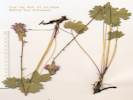 Coll. No. 437, Sidalcea oregana ssp. spicata Coll. No. 437, Sidalcea oregana ssp. spicata
437
|
Sidalcea oregana (Torr. & A. Gray) A. Gray ssp. spicata (Regel) C. L. Hitchc. Oregon Checkerbloom.
| Big Spring, Alpine County, California. Monitor Pass area, at Big Spring, 0.8 mile northeast of Leviathan Peak, 2.8 air miles west of Topaz Lake. 38.6912°N, 119.6011°W. WGS 1984. Elev. 2385 m. Coll. No. 437, keyed 10 Dec 2012, characters observed: Perennial, rhizomed, 40-45 cm.; Stem stellate + puberulent (almost strigose); 1° peduncle 2.0-3.5 cm. or 20 cm (depending on whether those little accessory things are stipules or bracts); Involucel 0 (=bractlets 0); Inflorescence dense, 4-5 cm.; Bracts narrow, to 6.5 mm (occasionally barely > youngest flower buds); Calyx, young 5 mm, in fruit 6 mm, stellate + puberulent; Flower generally 17 mm wide; Petals 5; Anthers in 2 series; Stigmas linear; Fruit of segments; Segments 6, smooth, beak 0.6 mm.
|
Other articles:
Locations: Big Spring.
|
Yellow Rosaceae, Geum(?)
|
|
Other articles:
Locations:
Big Spring.
438.1
|
Geum macrophyllum Willd. var. perincisum (Rydb.) Raup. Large-leaf Avens.
| Big Spring, Alpine County, California. Monitor Pass area, at Big Spring, 0.8 mile northeast of Leviathan Peak, 2.8 air miles west of Topaz Lake. 38.6912°N, 119.6011°W. WGS 1984. Elev. 2385 m. Coll. No. 438.1, 12 Nov 2012, characters observed: Perennial herb, to 50 cm., plant drying green; Leaves, upper stem leaves divided near to base; Sepals 5; Hypanthium bractlets (not visible); Petals 5 (not visible); Style continuous to fruit, 3 mm., hooked, not plumose, without bristles, non-glandular; Fruit, many per flower, 2.5 mm.
|
Other articles:
Locations:
Big Spring.
438.2
|
|
Big Spring, Alpine County, California. Monitor Pass area, at Big Spring, 0.8 mile northeast of Leviathan Peak, 2.8 air miles west of Topaz Lake. 38.6912°N, 119.6011°W. WGS 1984. Elev. 2385 m. Coll. No. 438.2, keyed 12 Nov 2012, characters observed: Perennial, to 50 cm.; Stem ascending, hairs spreading, not shaggy or cottony; Leaf palmately compound; Leaflets 7, 21-toothed, to 1/2 mid-vein, surfaces similarly hairy; Inflorescence in cymes; Receptacle in fruit not strawberry-like; Hypanthium shallow; Stamens 17-18; Style jointed to fruit, thickest at base, not hairy, 1.7-1.9 mm.
|
|
From here I continued a small way northwest along the road. It looks as though one could circumnavigate Leviathan Peak by staying on this road.
|
|
|
However, I spied a small road following Mountaineer Creek and followed it. This road does not show on the DeLorme TopoUSA. Down this road a short way was a horse camp. And the road looked pretty good, like it might follow Mountaineer Creek for quite a way.
|
|
Other articles:
|
After a short break, I began to return to CA Hwy 89. However, about a quarter-mile before reaching CA Hwy 89, I stopped to collect the paintbrush, at 11S 274295 4284984, elevation 2403 m. Everywhere in this little valley has a little tinge of read from the paintbrush. The dominant vegetation is sagebrush and an iris. I also saw an Arenaria, but saw none in bloom.
|
|
Other articles:
439
|
Castilleja linariifolia Benth. Wyoming Indian Paintbrush.
| Monitor Pass, Alpine County, California. In a small valley that forms the headwaters of Mountaineer Creek, 0.9 mi (1.5 km) east of Leviathan Peak. 38.6847°N, 119.5949°W. WGS 1984. Elev. 2403 m. Very common, growing out of Artemisia, giving this small valley a tinge of red. There is also an Arenaria and an Iris here, but neither are in bloom. Coll. No. 439, 31 Jul 2004, characters observed while keying: Annual/perennial unknown, to 50 cm., plants of dry places, growing out of Artemisia; Stem and leaf glabrous; Leaf, linear, proximal 60 mm. × 2 mm. wide, margins curled up, length reduced distally to 15 mm, occasionally 3- or 5-lobed; Inflorescence, simple hairy; Bracts, 3-lobed, <calyx; Calyx, 26 mm., divided 14/26 (54%) abaxially and undivided adaxially, lobes curved upward; Corolla curved out through abaxial calyx sinus, beak described as sparsely puberulent, but unable to see in this collection.
|
Other articles:
Locations:
Sweetwater Mountains.
|
Stopped at the usual overlook for a nice view of Slinkard Valley.
|
|
Other articles:
|
Turned north on US Hwy 395 from CA Hwy 89.
|
|
|
Spent the night at the Topaz Lake Inn and Casino.
|
|
|
[Previous Page]
[Next Page]
| Go to page: [1800s] [1900s] [1910s] [1920s] [1930s] [1940s] [1950s] [1960s] [1970s] [1980s] [1990] [1991] [1992] [1993] [1994] [1995] [1996] [1997] [1998] [1999] [2000] [2001] [2002] [2003] [2004] [2005] [2006] [2007] [2008] [2009] [2010] [2011] [2012] [2013] [2014] [2015] [2016] [2017] [2018] [2019] [2020] [2021] [2022] [2023] [2024] [2025] [A]
If you have a question or a comment you may write to me at:
tomas@schweich.com
I sometimes post interesting questions in my FAQ, but I never disclose your full name or address.
|
|
Date and time this article was prepared: 4/21/2025 8:22:40 PM | ||||||||||||||||||||