
Eastern Mojave Vegetation
By Tom Schweich
|
Eastern Mojave Vegetation | Images -- Geography - Hinsdale County, CO |
|
By Tom Schweich |
|

Unclassified Geography - Idaho Geography - Park County, CO Geography - Summit County, CO Geography - Arizona Geography - British Columbia Geography - California Geography - California's Colorado Desert Alaska Geography - Mono Lake Basin, California Geography - Mono County, California Geography - San Luis Obispo County, California Geography - Marin County, California Geography - Santa Clara County Alameda Garden Geography - Central Mojave Geography - New Mexico Geography - Eastern Mojave Geography - Northern Mojave Geography - Colorado Geography - Alamosa County, CO Geography - Boulder County, CO Geography - Clear Creek County, CO Geography - Chaffee County, CO Geography - Douglas County, CO Geography - Gilpin County, CO Geography - Golden, Colorado Geography - Weld County, CO Geography - Hinsdale County, CO Geography - Jefferson County, CO Geography - North Table Mountain, Jefferson Cty, CO Geography - Lake County, CO Geography - Larimer County, CO Geography - Nevada Geography - Oregon Geography - Utah Geography - Virginia Geography - Washington Geography - Wyoming Spain - Andalucia Spain - Castilla y Leon Spain - Castilla-La Mancha Spain - Extremadura Spain - Galicia Spain - Madrid Portugal Geology Economic Geology Climatology Botany Salvia dorrii Frasera albomarginata Species Species - Polygonaceae Species - Brassicaceae Species - Brassicaceae, Physaria vitulifera Species - Rosaceae Species - Fabaceae Species - Onagraceae Species - Polemoniaceae Species - Boraginaceae Species - Plantaginaceae Species - Asteraceae Species - Poaceae Zoology Ecology Archeology Customer Satisfaction General Arizona California Kansas Missouri Nebraska New York Christmas 2002 Family Photos Family Documents Family Photos 2003 Art of Lydia Schweich Portraits Railroad Geography - Germany |
Images are organized by the topics listed at left. Click on a topic name to see images with that topic. Would you like to use these photographs in your school term paper or report? License is hereby granted for non-commercial use of the images contained herein provided that the images are reproduced with the copyright notice intact. This means that we give you our permission to use the photographs and information you find here in your school term papers and reports. You may resize the photograph to fit your needs, but you may not remove the copyright. Your term paper should note that the photographs are reproduced with permission and it should have a reference to this web site, such as: "Photograph �1999 Tom Schweich. Used by permission, http://www.schweich.com" If you have a comment or a question about a photograph you may write to me at tas4@schweich.com I will answer you as soon as I can. I sometimes post interesting questions in my FAQ, but I will not disclose your full name or address.
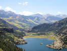
| Clear Creek Graben
| 
Clear Creek Graben | Photographed 18 September 2017. The Clear Creek Graben extends from the valley in the very left middleground, just below Bristol Head, to the linear valley hidden in the right middleground. The Rio Grande River is in the linear valley, which is called Antelope Park.The gently sloped hummocky hill in the left middle ground is glacial till on the downdropped block.
Article records that use this photograph:
images/IMGQ4324sm.jpg
| Lake City
| 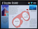
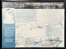
Interpretive panel for Lake City Caldera | Photographed 18 September 2017.
Location records that use this photograph:
Article records that use this photograph:
images/IMGQ4294sm.jpg
| 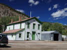
Hinsdale County Court House | Photographed 18 September 2017.
Location records that use this photograph:
Article records that use this photograph:
images/IMGQ4295sm.jpg
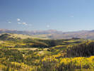
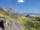
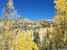
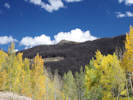
| 
Turning aspens above Lake City | Photographed 18 September 2017.
Location records that use this photograph:
Article records that use this photograph:
images/IMGQ4297sm.jpg
| 
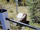
Interpretive panel at Alferd Packer massacre site. | Photographed 18 September 2017.
Location records that use this photograph:
Article records that use this photograph:
images/20170918_131346sm.jpg
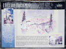
| 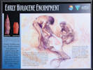
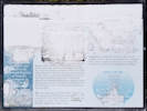
Interpretive panel for Early Holocene Encampment | Photographed 18 September 2017.
Article records that use this photograph:
images/IMGQ4293sm.jpg
| 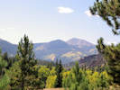
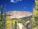
Hazy view of turning aspens | Photographed 18 September 2017.
Article records that use this photograph:
images/IMGQ4292sm.jpg
| 
Plaque at Alferd Packer massacre site. | Photographed 18 September 2017.
Location records that use this photograph:
Article records that use this photograph:
images/20170918_131411sm.jpg
| Lake San Cristobal
| 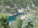
Lower end of Lake San Cristobal | Photographed 18 September 2017. The houses in the right middleground are built on the toe of the Smulgullion Earthflow.
Location records that use this photograph:
Article records that use this photograph:
images/IMGQ4307sm.jpg
| 
Upper end of Lake San Cristobal | Photographed 18 September 2017.
Location records that use this photograph:
Article records that use this photograph:
images/IMGQ4308sm.jpg
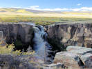
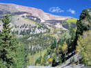
| North Clear Creek Falls
| 
View southwest from North Clear Creek Falls | Photographed 18 September 2017. The promontory on the left is Bristol Head. The valley in the center is formed by the northeast boundary fault of the Clear Creek Graben. The low hill in the right middle ground is composed of glacial till on the downdropped block of the Clear Creek Graben. The southwest boundary fault of the Clear Creek Graben is out of view to the right.
Location records that use this photograph:
Article records that use this photograph:
images/IMGQ4323sm.jpg
| 
North Clear Creek Falls | Photographed 18 September 2017.
Location records that use this photograph:
Article records that use this photograph:
images/IMGQ4320sm.jpg
| Rio Grande River
| 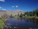
The Rio Grande River exits from the San Juan Mountains | Photographed 18 September 2017.
Location records that use this photograph:
Article records that use this photograph:
images/IMGQ4326sm.jpg
| Slumgullion Earthflow
| 
Slumgullion Earthflow from Lake San Cristobal Overlook | Photographed 18 September 2017.
Location records that use this photograph:
Article records that use this photograph:
images/IMGQ4305sm.jpg
| 
View of Slumgullion from the official viewpoint | Photographed 18 September 2017.
Location records that use this photograph:
Article records that use this photograph:
images/20170918_132808sm.jpg
| 
Interpretive panel at Windy Point Overlook | Photographed 18 September 2017.
Location records that use this photograph:
Article records that use this photograph:
images/IMGQ4312sm.jpg
| 
Head scarp of the Smulgullion Earthflow | Photographed 18 September 2017.
Location records that use this photograph:
Article records that use this photograph:
images/IMGQ4311sm.jpg
| 
Interpretive panel for Slumgullion Earthflow | Photographed 18 September 2017.
Location records that use this photograph:
Article records that use this photograph:
images/20170918_132814sm.jpg
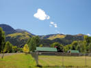
| Slumgullion Pass
| 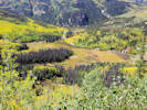
Meadow below Windy Point Overlook | Photographed 18 September 2017.
Article records that use this photograph:
images/IMGQ4317sm.jpg
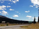
| Slumgullion Summit
| 
Beetle-killed trees on Slumgullion Summit | Photographed 18 September 2017.
Location records that use this photograph:
Article records that use this photograph:
images/IMGQ4310sm.jpg
| 
Slumgullion Summit | Photographed 18 September 2017.
Location records that use this photograph:
Article records that use this photograph:
images/20170918_142456sm.jpg
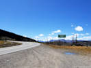
| Spring Creek Pass
| 
Spring Creek Pass, Continental Divide, 10,898 ft. | Photographed 18 September 2017.
Location records that use this photograph:
Article records that use this photograph:
images/20170918_143944sm.jpg
| Uncompahgre Peak
| 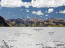
Uncompahgre Peak in the San Juan Mountains | Photographed 18 September 2017.
Location records that use this photograph:
Article records that use this photograph:
images/IMGQ4314e.jpg
|
| Date and time this article was prepared: 5/10/2024 11:14:18 AM | |||||||||||||||