
Eastern Mojave Vegetation
By Tom Schweich
|
Eastern Mojave Vegetation | Images -- Geography - Wyoming |
|
By Tom Schweich |
|

Unclassified Geography - Idaho Geography - Park County, CO Geography - Summit County, CO Geography - Arizona Geography - British Columbia Geography - California Geography - California's Colorado Desert Alaska Geography - Mono Lake Basin, California Geography - Mono County, California Geography - San Luis Obispo County, California Geography - Marin County, California Geography - Santa Clara County Alameda Garden Geography - Central Mojave Geography - New Mexico Geography - Eastern Mojave Geography - Northern Mojave Geography - Colorado Geography - Alamosa County, CO Geography - Boulder County, CO Geography - Clear Creek County, CO Geography - Chaffee County, CO Geography - Douglas County, CO Geography - Gilpin County, CO Geography - Golden, Colorado Geography - Weld County, CO Geography - Hinsdale County, CO Geography - Jefferson County, CO Geography - North Table Mountain, Jefferson Cty, CO Geography - Lake County, CO Geography - Larimer County, CO Geography - Nevada Geography - Oregon Geography - Utah Geography - Virginia Geography - Washington Geography - Wyoming Spain - Andalucia Spain - Castilla y Leon Spain - Castilla-La Mancha Spain - Extremadura Spain - Galicia Spain - Madrid Portugal Geology Economic Geology Climatology Botany Salvia dorrii Frasera albomarginata Species Species - Polygonaceae Species - Brassicaceae Species - Brassicaceae, Physaria vitulifera Species - Rosaceae Species - Fabaceae Species - Onagraceae Species - Polemoniaceae Species - Boraginaceae Species - Plantaginaceae Species - Asteraceae Species - Poaceae Zoology Ecology Archeology Customer Satisfaction General Arizona California Kansas Missouri Nebraska New York Christmas 2002 Family Photos Family Documents Family Photos 2003 Art of Lydia Schweich Portraits Railroad Geography - Germany |
Images are organized by the topics listed at left. Click on a topic name to see images with that topic. Would you like to use these photographs in your school term paper or report? License is hereby granted for non-commercial use of the images contained herein provided that the images are reproduced with the copyright notice intact. This means that we give you our permission to use the photographs and information you find here in your school term papers and reports. You may resize the photograph to fit your needs, but you may not remove the copyright. Your term paper should note that the photographs are reproduced with permission and it should have a reference to this web site, such as: "Photograph �1999 Tom Schweich. Used by permission, http://www.schweich.com" If you have a comment or a question about a photograph you may write to me at tas4@schweich.com I will answer you as soon as I can. I sometimes post interesting questions in my FAQ, but I will not disclose your full name or address.
| Cody County
| 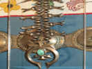
Squash Blossom Necklace | Photograph taken 15 August 2011.
(A headstall for a horse is a hanger put on a horse's head used for holding a bit, bosal, nose piece, or other piece of equipment to control a horse while riding. When a headstall is combined with a bit (or bosal, nose piece, etc.) the combination is known as a bridle.)
Article records that use this photograph:
images/IMG_2416sm.jpg
| Converse County
| 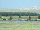
A loaded and an empty BNSF coal train meet between Glendo and Orin, Wyoming. | Photographed 13 August 2018.
Article records that use this photograph:
images/IMG50482sm.jpg
| Fremont County
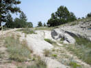
| 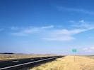
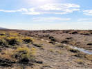
South Pass. | Photographed 4 September 2018.
Location records that use this photograph:
Article records that use this photograph:
images/20180904_172442sm.jpg
| 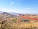
Red Canyon Rim south of Lander. | Photographed 4 September 2018.
Article records that use this photograph:
images/20180904_165724sm.jpg
| 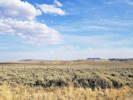
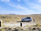
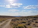
View south toward Oregon Buttes. | Photographed 4 September 2018.
Location records that use this photograph:
Article records that use this photograph:
images/20180904_172446sm.jpg
| 
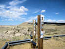
Marker at South Pass. | Photographed 4 September 2018.
Location records that use this photograph:
Article records that use this photograph:
images/20180904_174122sm.jpg
| 
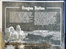
Marker for Old Oregon Trail. | Photographed 4 September 2018.
Location records that use this photograph:
Article records that use this photograph:
images/20180904_174137sm.jpg
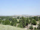
| 
The view east | Photographed 4 September 2018.
Location records that use this photograph:
Article records that use this photograph:
images/20180904_174235sm.jpg
| 
A ditch carries Sweetwater River water across the continental divide. | Photographed 4 September 2018.
Location records that use this photograph:
Article records that use this photograph:
images/20180904_174441sm.jpg
| 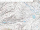
How water gets diverted from the Sweetwater River. | Drawn 28 September 2018.
Location records that use this photograph:
Article records that use this photograph:
images/Sweetwater_to_Pacific_No_1.jpg
| 
South Pass | Photographed 4 September 2018.
Location records that use this photograph:
Article records that use this photograph:
images/20180904_174531sm.jpg
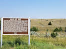
| 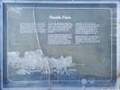
Interpretive panel for South Pass. | Photographed 4 September 2018.
Location records that use this photograph:
Article records that use this photograph:
images/20180904_174722sm.jpg
| 
Lander Cut-Off on the Oregon Trail | Photographed 4 September 2018.
Article records that use this photograph:
images/20180904_171622sm.jpg
| 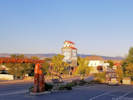
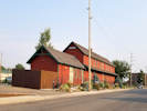
The former feed mill in Lander, now a bicycle shop. | Photographed 4 September 2018.
Location records that use this photograph:
Article records that use this photograph:
images/20180905_072651sm.jpg
| 
The view west. | Photographed 4 September 2018.
Location records that use this photograph:
Article records that use this photograph:
images/20180904_174153sm.jpg
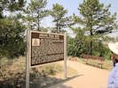
| 
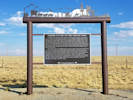
Interpretive panel for Oregon Buttes | Photographed 4 September 2018.
Location records that use this photograph:
Article records that use this photograph:
images/20180904_175450sm.jpg
| 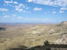
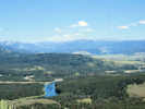
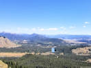
View of Wind River Basin from southeast rim. | Photograph taken 14 August 2011.
Location records that use this photograph:
Article records that use this photograph:
images/IMG_2397sm.jpg
| 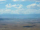
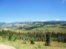
View of Absaroka Range across the Wind River Basin | Photograph taken 14 August 2011.
Location records that use this photograph:
Article records that use this photograph:
images/IMG_2398sm.jpg
| 
Prayer Flags (?) at the Wind River Basin view point. | Photograph taken 14 August 2011.
Article records that use this photograph:
images/IMG_2400sm.jpg
| Grand Teton National Park
| 
Willow Flats with Teton Range in distance | Photograph taken 18 August 2011.
Location records that use this photograph:
Article records that use this photograph:
images/IMG_2495sm.jpg
| 
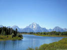
The view from Oxbow Bend Turnout | Photograph taken 18 Aug 2011.
Location records that use this photograph:
Article records that use this photograph:
images/IMG_2499sm.jpg
| 
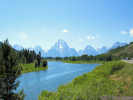
View east from Signal Mountain | Photograph taken 18 Aug 2011. The Snake River is in the left foreground, and the Absaroka Range in the distance.
Location records that use this photograph:
Article records that use this photograph:
images/IMG_2503sm.jpg
| 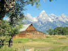
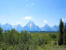
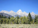
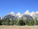
Teton Range from Mormon Row | Photograph taken 19 Aug 2011.
Location records that use this photograph:
Article records that use this photograph:
images/IMG_2509sm.jpg
| Hot Springs County
| 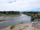
Big Horn River in Thermopolis | Photograph taken 15 August 2011.
Location records that use this photograph:
Article records that use this photograph:
images/IMG_2403sm.jpg
| 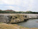
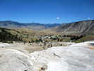
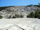
Hot springs terrace beside the Big Horn River | Photograph taken 15 August 2011.
Location records that use this photograph:
Article records that use this photograph:
images/IMG_2404sm.jpg
| 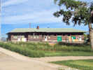
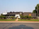
BNSF depot in Thermopolis | Photograph taken 15 August 2011.
Location records that use this photograph:
Article records that use this photograph:
images/IMG_2412sm.jpg
| Lincoln County
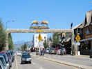
| 
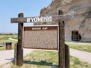
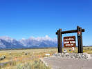
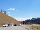
Welcome to Wyoming! | Photographed 21 October 2017.
Article records that use this photograph:
images/20171021_155101sm.jpg
| 
Afton, Wyoming | Photograph taken 19 Aug 2011
Location records that use this photograph:
Article records that use this photograph:
images/IMG_2515sm.jpg
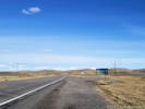
| 
Salt River Pass on US Highway 89 | Photograph taken 19 Aug 2011
Location records that use this photograph:
Article records that use this photograph:
images/IMG_2516sm.jpg
| Platte County
| 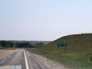
Entrance to Chugwater, Wyoming. | Photographed 13 August 2018.
Location records that use this photograph:
Article records that use this photograph:
images/20180813_114940sm.jpg
| 
Interpretive panel at Register Cliff | Photographed 13 August 2018.
Location records that use this photograph:
Article records that use this photograph:
images/20180813_133640sm.jpg
| 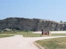
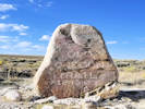
Register Cliff State Historic Site. | Photographed 13 August 2018.
Location records that use this photograph:
Article records that use this photograph:
images/20180813_133455sm.jpg
| 
Interpretive panel for Rifle Pit Hill along US Highway 26. | Photographed 13 August 2018.
Article records that use this photograph:
images/20180813_123505sm.jpg
| 
Oregon Trail Ruts through a sandstone ridge. | Photographed 13 August 2018.
Location records that use this photograph:
Article records that use this photograph:
images/IMG50474sm.jpg
| 
View of Gurnsey from the nearby Oregon Trail Ruts. | Photographed 13 August 2018.
Location records that use this photograph:
Article records that use this photograph:
images/IMG50473sm.jpg
| 
Oregon Trail Ruts interpretive panel. | Photographed 13 August 2018.
Location records that use this photograph:
Article records that use this photograph:
images/IMG50472sm.jpg
| 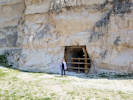
Local ranchers dug this tunnel into Register Cliff to store their crops. | Photographed 13 August 2018.
Location records that use this photograph:
Article records that use this photograph:
images/20180813_134132sm.jpg
| 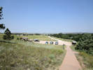
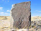
Oregon Trail Ruts interpretive site. | Photographed 13 August 2018. Oregon Trail Ruts State Historic Site is a preserved site of wagon ruts of the Oregon Trail on the North Platte River, about 0.5 miles south of Guernsey, Wyoming. The Oregon Trail here was winding up towards South Pass. Wagon wheels, draft animals, and people wore down the trail about two to six feet into a sandstone ridge here, during its heavy usage from 1841�1869. The half-mile stretch is "unsurpassed" and is the best-preserved set of Oregon Trail ruts anywhere along its former length.
Location records that use this photograph:
Article records that use this photograph:
images/IMG50470sm.jpg
| 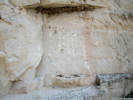
Registrations at Register Cliff; mostly modern. | Photographed 13 August 2018.
Location records that use this photograph:
Article records that use this photograph:
images/IMG50476sm.jpg
| 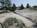
Oregon Trail Ruts through a sandstone ridge. | Photographed 13 August 2018. Oregon Trail Ruts State Historic Site is a preserved site of wagon ruts of the Oregon Trail on the North Platte River, about 0.5 miles south of Guernsey, Wyoming. The Oregon Trail here was winding up towards South Pass. Wagon wheels, draft animals, and people wore down the trail about two to six feet into a sandstone ridge here, during its heavy usage from 1841�1869. The half-mile stretch is "unsurpassed" and is the best-preserved set of Oregon Trail ruts anywhere along its former length.
Location records that use this photograph:
Article records that use this photograph:
images/IMG50471sm.jpg
| 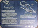
Encampments in the Guernsey Area. | Photographed 13 August 2018.
Location records that use this photograph:
Article records that use this photograph:
images/IMG50475sm.jpg
| 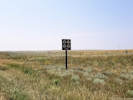
One of many signs along the highway showing where a historic trail crosses. | Photographed 13 August 2018.
Article records that use this photograph:
images/20180813_140233sm.jpg
| Sheridan County
| 
The Original 1892 Wood Sheridan Railroad Depot | Photographed 13 August 2018.
Location records that use this photograph:
Article records that use this photograph:
images/20180813_181615sm.jpg
| 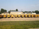
All the busses with their backsides turned to the tourists in the hotel. | Photographed 13 August 2018.
Location records that use this photograph:
Article records that use this photograph:
images/20180813_180317sm.jpg
| 
CB&Q 5631 a 4-8-4 “Northern” on display in Sheridan, WY | Photographed 13 August 2018.
Location records that use this photograph:
Article records that use this photograph:
images/20180813_181332sm.jpg
| 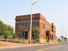
The 1912 Brick Sheridan Railroad Depot | Photographed 13 August 2018.
Location records that use this photograph:
Article records that use this photograph:
images/20180813_181719sm.jpg
| Teton County
| 
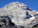
Mount Moran behind The Oxbow | Photographed 4 September 2018.
Location records that use this photograph:
Article records that use this photograph:
images/IMG50549sm.jpg
| 
Grand Teton (peak) | Photographed 4 September 2018.
Location records that use this photograph:
Article records that use this photograph:
images/IMG50525sm.jpg
| 
Grand Teton National Park. | Photographed 4 September 2018.
Location records that use this photograph:
Article records that use this photograph:
images/20180904_111935sm.jpg
| 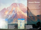
Interpretive panel for Mount Moran. | Photographed 4 September 2018.
Location records that use this photograph:
Article records that use this photograph:
images/20180904_125532sm.jpg
| 
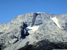
Middle Teton, with basaltic dike. | Photographed 4 September 2018.
Location records that use this photograph:
Article records that use this photograph:
images/IMG50532sm.jpg
| 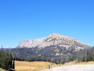
Breccia Peak and Cliffs from Togwotee Pass. | Photographed 4 September 2018.
Location records that use this photograph:
Article records that use this photograph:
images/20180904_144049sm.jpg
| 
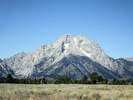
Mount Moran | Photographed 4 September 2018.
Location records that use this photograph:
Article records that use this photograph:
images/IMG50545sm.jpg
| 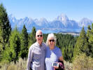
Us on Signal Mountain. | Photographed 4 September 2018.
Location records that use this photograph:
Article records that use this photograph:
images/20180904_132046sm.jpg
| 
View east from Signal Mountain | Photographed 4 September 2018.
Location records that use this photograph:
Article records that use this photograph:
images/20180904_133643sm.jpg
| 
A Chestwig of Corvettes on Togwotee Pass. | Photographed 4 September 2018.
Location records that use this photograph:
Article records that use this photograph:
images/20180904_144045sm.jpg
| 
Middle Teton, with basaltic dike. | Photographed 4 September 2018.
Location records that use this photograph:
Article records that use this photograph:
images/IMG50530sm.jpg
| 
Mount Moran | Photographed 4 September 2018.
Location records that use this photograph:
Article records that use this photograph:
images/IMG50544sm.jpg
| Teton Range
| 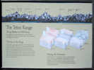
Interpretive sign for Teton Range |
Location records that use this photograph:
images/IMG_2498sm.jpg
| Yellowstone National Park
| 
Town of Mammoth, with Montana in the background. | Photograph taken 17 August 2011.
Location records that use this photograph:
Article records that use this photograph:
images/IMG_2461sm.jpg
| 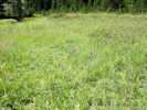
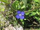
Field of Gentians at Apollinaris Spring | Photograph taken 17 August 2011.
Location records that use this photograph:
Article records that use this photograph:
images/IMG_2462sm.jpg
| 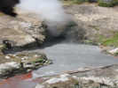
Dragon's Mouth Spring | Photograph taken 16 August 2011.
Location records that use this photograph:
Article records that use this photograph:
images/IMG_2425sm.jpg
| 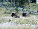
Buffalo rest at Mud Volcano | Photograph taken 16 August 2011.
Location records that use this photograph:
Article records that use this photograph:
images/IMG_2423sm.jpg
| 
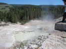
Churning Cauldron at Mud Volcano | Photograph taken 16 August 2011.
Location records that use this photograph:
Article records that use this photograph:
images/IMG_2421sm.jpg
| 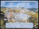
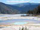
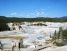
Mammoth Hot Springs Terraces | Photograph taken 17 August 2011.
Location records that use this photograph:
Article records that use this photograph:
images/IMG_2453sm.jpg
| 
Roaring Mountain | Photograph taken 17 August 2011.
Location records that use this photograph:
Article records that use this photograph:
images/IMG_2452sm.jpg
| 
Another one? Pretty sure it was at Artist Paint Pots | Photograph taken 17 August 2011.
Location records that use this photograph:
Article records that use this photograph:
images/IMG_2470sm.jpg
| 
View north of Willow Park | Photograph taken 17 August 2011.
Location records that use this photograph:
Article records that use this photograph:
images/IMG_2465sm.jpg
| 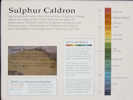
Interpretive sign at Sulphur Caldron | Photograph taken 16 August 2011.
Location records that use this photograph:
Article records that use this photograph:
images/IMG_2426sm.jpg
| 
Gentian at Apollinaris Spring | Photograph taken 17 August 2011.
Location records that use this photograph:
Article records that use this photograph:
images/IMG_2463sm.jpg
| 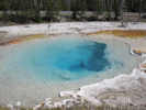
I wonder which pool this was? | Photograph taken 17 August 2011. I think it might have been Silex Spring.
Location records that use this photograph:
Article records that use this photograph:
images/IMG_2467sm.jpg
| 
Terrace of Mammoth Hot Springs | Photograph taken 17 August 2011.
Location records that use this photograph:
Article records that use this photograph:
images/IMG_2459sm.jpg
| 
Sulphur Caldron | Photograph taken 16 August 2011.
Location records that use this photograph:
Article records that use this photograph:
images/IMG_2428sm.jpg
| 
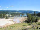
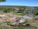
View of Norris Geyser Basin | Photograph taken 16 August 2011.
Location records that use this photograph:
Article records that use this photograph:
images/IMG_2435sm.jpg
| 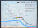
Orientation sign at Mud Volcano. | Photograph taken 16 August 2011.
Location records that use this photograph:
Article records that use this photograph:
images/IMG_2419sm.jpg
| 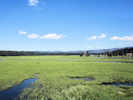
Sedge Creek beside Yellowstone Lake. | Photograph taken 16 August 2011.
Location records that use this photograph:
Article records that use this photograph:
images/IMG_2417sm.jpg
| 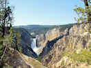
Lower Yellowstone Falls from Artist Point | Photograph taken 16 August 2011.
Location records that use this photograph:
Article records that use this photograph:
images/IMG_2429sm.jpg
| 
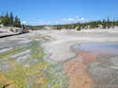
Overview of Artist Paintpot | Photograph taken 17 August 2011.
Location records that use this photograph:
Article records that use this photograph:
images/IMG_2447sm.jpg
| 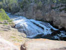
Gibbon Falls | Photograph taken 17 August 2011.
Location records that use this photograph:
Article records that use this photograph:
images/IMG_2445sm.jpg
| 
Two colors of bacteria in thermal waters | Photograph taken 16 August 2011.
Location records that use this photograph:
Article records that use this photograph:
images/IMG_2440sm.jpg
| 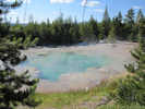
Emerald Pool in the Norris Geyser Basin | Photograph taken 16 August 2011.
Location records that use this photograph:
Article records that use this photograph:
images/IMG_2444sm.jpg
| 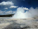
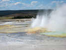
Pretty sure this one was Fountain Geyser | Photograph taken 17 August 2011.
Location records that use this photograph:
Article records that use this photograph:
images/IMG_2472sm.jpg
| | |||||||||||||||||||||||||||||||||||||||||