
Eastern Mojave Vegetation
By Tom Schweich
|
Eastern Mojave Vegetation | Images -- Geography - San Luis Obispo County, California |
|
By Tom Schweich |
|

Unclassified Geography - Idaho Geography - Park County, CO Geography - Summit County, CO Geography - Arizona Geography - British Columbia Geography - California Geography - California's Colorado Desert Alaska Geography - Mono Lake Basin, California Geography - Mono County, California Geography - San Luis Obispo County, California Geography - Marin County, California Geography - Santa Clara County Alameda Garden Geography - Central Mojave Geography - New Mexico Geography - Eastern Mojave Geography - Northern Mojave Geography - Colorado Geography - Alamosa County, CO Geography - Boulder County, CO Geography - Clear Creek County, CO Geography - Chaffee County, CO Geography - Douglas County, CO Geography - Gilpin County, CO Geography - Golden, Colorado Geography - Weld County, CO Geography - Hinsdale County, CO Geography - Jefferson County, CO Geography - North Table Mountain, Jefferson Cty, CO Geography - Lake County, CO Geography - Larimer County, CO Geography - Nevada Geography - Oregon Geography - Utah Geography - Virginia Geography - Washington Geography - Wyoming Spain - Andalucia Spain - Castilla y Leon Spain - Castilla-La Mancha Spain - Extremadura Spain - Galicia Spain - Madrid Portugal Geology Economic Geology Climatology Botany Salvia dorrii Frasera albomarginata Species Species - Polygonaceae Species - Brassicaceae Species - Brassicaceae, Physaria vitulifera Species - Rosaceae Species - Fabaceae Species - Onagraceae Species - Polemoniaceae Species - Boraginaceae Species - Plantaginaceae Species - Asteraceae Species - Poaceae Zoology Ecology Archeology Customer Satisfaction General Arizona California Kansas Missouri Nebraska New York Christmas 2002 Family Photos Family Documents Family Photos 2003 Art of Lydia Schweich Portraits Railroad Geography - Germany |
Images are organized by the topics listed at left. Click on a topic name to see images with that topic. Would you like to use these photographs in your school term paper or report? License is hereby granted for non-commercial use of the images contained herein provided that the images are reproduced with the copyright notice intact. This means that we give you our permission to use the photographs and information you find here in your school term papers and reports. You may resize the photograph to fit your needs, but you may not remove the copyright. Your term paper should note that the photographs are reproduced with permission and it should have a reference to this web site, such as: "Photograph �1999 Tom Schweich. Used by permission, http://www.schweich.com" If you have a comment or a question about a photograph you may write to me at tas4@schweich.com I will answer you as soon as I can. I sometimes post interesting questions in my FAQ, but I will not disclose your full name or address.
| Atascadero
| 
Headstone for Paul A. Schweich | Photograph taken 9 July 2011.
images/IMG_2086sm.jpg
| 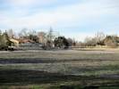
Atascadero Lake, without water. | Photographed 18 January 2015.
Location records that use this photograph:
Article records that use this photograph:
images/IMG40794sm.jpg
| Cayucos
| 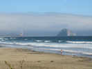
View south along the beach to Morro Bay from Cayucos. | Photograph taken 11 July 2011.
Location records that use this photograph:
Article records that use this photograph:
images/IMG_2119sm.jpg
| Cuesta Grade
| 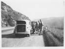
A crew of guys help Peggy Stoddard change a flat, April 18, 1945. | Photographed, 18 April 1945,
Article records that use this photograph:
images/19450418_SLO_01sm.jpg
| 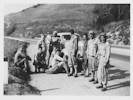
A crew of guys help Peggy Stoddard change a flat, April 18, 1945. | Photographed, 18 April 1945, the second man from the right wears a patch indicating an Army rank of Technician Fifth Class.
Article records that use this photograph:
images/19450418_SLO_02sm.jpg
| Cuesta Ridge
| 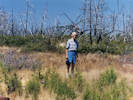
Paul Schweich (my dad) on Cuesta Ridge. | Probably photographed June 1999.
Location records that use this photograph:
Article records that use this photograph:
images/199906_Cuesta_Paulsm.jpg
| 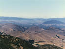
San Luis Obispo seen from Cuesta Ridge. | Probably photographed June 1999.
Location records that use this photograph:
Article records that use this photograph:
images/199906_SLOsm.jpg
| 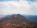
Cerro Alto from TV Tower Road. | Photographed in August 1990. Photo was probably taken from Tassajera Peak.
Location records that use this photograph:
Article records that use this photograph:
images/9081_img191sm.jpg
| 
My dad and Sheba the dog on Cuesta Ridge. | Photographed in August 1990.
Location records that use this photograph:
Article records that use this photograph:
images/9081_img185sm.jpg
| Harmony Headlands State Park
| 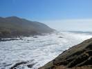
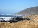
Shoreline to the south. | Photographed 3 February 2013.
Location records that use this photograph:
Article records that use this photograph:
images/IMG_1036sm.jpg
| 
Shoreline to the north. | Photographed 3 February 2013.
Location records that use this photograph:
Article records that use this photograph:
images/IMG_1034sm.jpg
| 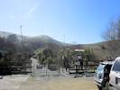
Entrance to Harmony Headlands State Park. | Photographed 3 February 2013.
Location records that use this photograph:
Article records that use this photograph:
images/IMG_1040sm.jpg
| 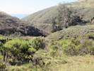
Coastal chapparral | Photographed 3 February 2013.
Location records that use this photograph:
Article records that use this photograph:
images/IMG_1038sm.jpg
| Hi Mountain Campground
| 
Camping at Hi Mountain Campground. | Photographed July 1966. In July, 1996, Cheryl and I went camping with Larry and Karol at the Hi Mountain Campground. Being July, we planned to sleep out because it never rains in July. Well, it rained. The best shelter we could arrange was to pull a sheet of plywood out of the bed of Larry's truck. That sheltered our heads, but the rest of us was sticking out in the rain. Also the rain brought the bugs out. So we got bitten a lot. Regardless, we did not give up, and stayed the entire night.
Article records that use this photograph:
images/196607010sm.jpg
| Morro Bay
| 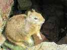
Squirrel at Morro Bay | Photograph by Isabel Albaladejo Pozo, 12 July 2011.
Location records that use this photograph:
Article records that use this photograph:
images/IMG_2143sm.jpg
| 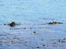
Sea otters at Morro Bay. | Photograph made 12 Jul 2011.
Location records that use this photograph:
Article records that use this photograph:
images/IMG_2125sm.jpg
| 
Morro Strand State Beach. | Photograph taken 30 November 2008. This photo was taken from the parking lot at Morro Rock and looks north along the beach. The northern portion of the city of Morro Bay is on the hill in the distance.
Location records that use this photograph:
Article records that use this photograph:
images/IMG01403sm.jpg
| Morro Rock
| 
North side of Morro Rock. | Photograph taken 30 November 2008.
Location records that use this photograph:
Article records that use this photograph:
images/IMG_1402sm.jpg
| Rinconada Mine
| 
Largest pit at the Rinconada Mine. | Photograph taken 29 December 2008.
Location records that use this photograph:
Article records that use this photograph:
images/IMG01445sm.jpg
| 
Condensers at Rinconada Mine | Photograph taken 29 December 2008.
Location records that use this photograph:
Article records that use this photograph:
images/IMG01436sm.jpg
| 
Mill area at Rinconada Mine | Photograph taken 29 December 2008.
Location records that use this photograph:
Article records that use this photograph:
images/IMG_1444sm.jpg
| 
View of Morro Bay from the south | Photograph taken 30 December 2008.
Location records that use this photograph:
Article records that use this photograph:
images/IMG01454sm.jpg
| 
View northwest from vicinity of Rinconada Mine | Photograph taken 27 December 2008.
Article records that use this photograph:
images/IMG_1432sm.jpg
| 
View northwest across the Rinconada Mine. | Photograph taken 29 December 2008. The little flat in the foreground is at the top of the Rinconada Mine.
Location records that use this photograph:
Article records that use this photograph:
images/IMG01433sm.jpg
| 
View east from near the Rinconada Mine. | Photograph taken 29 December 2008.
Article records that use this photograph:
images/IMG_1431sm.jpg
| 
Upper area, possibly daylighted adit, at the Rinconada Mine | Photograph taken 29 December 2008.
Location records that use this photograph:
Article records that use this photograph:
images/IMG01449sm.jpg
| 
Furnace at Rinconada Mine | Photograph taken 29 December 2008.
Location records that use this photograph:
Article records that use this photograph:
images/IMG01438sm.jpg
| San Luis Obispo
| 
November morning on Sierra Way. | Photographed in November 1968, scanned from a slide in 2023.
Location records that use this photograph:
Article records that use this photograph:
images/1968-11-00-img409sm.jpg
| 
Cheryl works at the Post Office during Christmas vacation. | Scanned in 2023 from a slide stanped DEC 66. The image was photographed from a local television news report.
Article records that use this photograph:
images/1966-12-img510sm.jpg
| 
Maybe a birthday party for Cheryl(?) | Maybe photographed May 1, 1945. Left to Right: #1: Mrs Victorino
House on Leff Street
Article records that use this photograph:
images/19450000_SLO_01sm.jpg
| 
Our first Christmas tree. | Photographed in December 1966, scanned from a slide in 2023.
Article records that use this photograph:
images/1966-12-25-img485sm.jpg
| Shell Creek
| 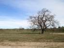
The tree at Shell Creek, January 2015. | Photographed 18 January 2015.
Article records that use this photograph:
images/IMG40784sm.jpg
| 
Looking north along Shell Creek, 2011 | Photographed 11 May 2012.
Article records that use this photograph:
images/IMG30122sm.jpg
| 
The tree at Shell Creek, May 2012 | Photographed 11 May 2012.
Article records that use this photograph:
images/IMG30119sm.jpg
|
| Date and time this article was prepared: 5/10/2024 11:14:53 AM | |||||||||||