
Eastern Mojave Vegetation
By Tom Schweich
|
Eastern Mojave Vegetation | Images -- Geography - Golden, Colorado |
|
By Tom Schweich |
|

Unclassified Geography - Idaho Geography - Park County, CO Geography - Summit County, CO Geography - Arizona Geography - British Columbia Geography - California Geography - California's Colorado Desert Alaska Geography - Mono Lake Basin, California Geography - Mono County, California Geography - San Luis Obispo County, California Geography - Marin County, California Geography - Santa Clara County Alameda Garden Geography - Central Mojave Geography - New Mexico Geography - Eastern Mojave Geography - Northern Mojave Geography - Colorado Geography - Alamosa County, CO Geography - Boulder County, CO Geography - Clear Creek County, CO Geography - Chaffee County, CO Geography - Douglas County, CO Geography - Gilpin County, CO Geography - Golden, Colorado Geography - Weld County, CO Geography - Hinsdale County, CO Geography - Jefferson County, CO Geography - North Table Mountain, Jefferson Cty, CO Geography - Lake County, CO Geography - Larimer County, CO Geography - Nevada Geography - Oregon Geography - Utah Geography - Virginia Geography - Washington Geography - Wyoming Spain - Andalucia Spain - Castilla y Leon Spain - Castilla-La Mancha Spain - Extremadura Spain - Galicia Spain - Madrid Portugal Geology Economic Geology Climatology Botany Salvia dorrii Frasera albomarginata Species Species - Polygonaceae Species - Brassicaceae Species - Brassicaceae, Physaria vitulifera Species - Rosaceae Species - Fabaceae Species - Onagraceae Species - Polemoniaceae Species - Boraginaceae Species - Plantaginaceae Species - Asteraceae Species - Poaceae Zoology Ecology Archeology Customer Satisfaction General Arizona California Kansas Missouri Nebraska New York Christmas 2002 Family Photos Family Documents Family Photos 2003 Art of Lydia Schweich Portraits Railroad Geography - Germany |
Images are organized by the topics listed at left. Click on a topic name to see images with that topic. Would you like to use these photographs in your school term paper or report? License is hereby granted for non-commercial use of the images contained herein provided that the images are reproduced with the copyright notice intact. This means that we give you our permission to use the photographs and information you find here in your school term papers and reports. You may resize the photograph to fit your needs, but you may not remove the copyright. Your term paper should note that the photographs are reproduced with permission and it should have a reference to this web site, such as: "Photograph �1999 Tom Schweich. Used by permission, http://www.schweich.com" If you have a comment or a question about a photograph you may write to me at tas4@schweich.com I will answer you as soon as I can. I sometimes post interesting questions in my FAQ, but I will not disclose your full name or address.
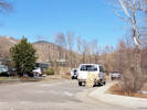
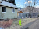
| “Hogback Valley”
| 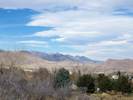
Winter View north through “Hogback Valley” | Photographed 14 February 2015.
Location records that use this photograph:
Article records that use this photograph:
images/IMGQ0141sm.jpg
| 19th Street
| 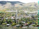
19th Street from rim of South Table Mountain | Photographed 15 October 2014.
Article records that use this photograph:
images/IMG40595sm.jpg
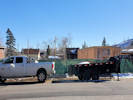
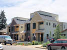
| 420 Arapahoe Street
| 
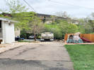
Parkway on 20 May 2023. | Photographed 20 May 2023.
Article records that use this photograph:
images/20230520_094150sm.jpg
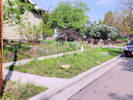
| 
Bootprints of whoever vandalized my parkway sprinklers. | Photographed 29 April 2023.
Article records that use this photograph:
images/20230429_091321sm.jpg
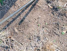
| 
Last night, someone broke off an irrigation pipe, stuck the pipe on the support, and bent the support over. | Photographed 29 April 2023.
Article records that use this photograph:
images/20230429_091306sm.jpg
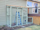
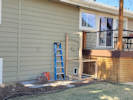
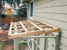
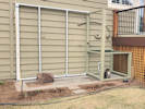
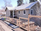
| 420 Arapahoe Street, Catio
| 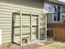
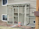
All the framing in place. Second coat of paint. Also finished the door; primed and one coat of paint. | Photographed 19 April 2023.
Article records that use this photograph:
images/20230419_112722sm.jpg
| 
One coat of paint. | Photographed 18 April 2023.
Article records that use this photograph:
images/20230418_152603sm.jpg
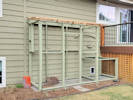
| 
Door outline framed, plus some miscellaneous pieces for wire placement. | Photographed 17 April 2023.
Article records that use this photograph:
images/20230417_172823sm.jpg
| 
Basic framing and priming ot front wall. | Photographed 16 April 2023.
Article records that use this photograph:
images/20230416_170304sm.jpg
| 
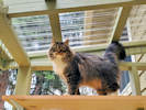
Solny and Myshka want to know when the catio will be finished. | Photographed 15 April 2023.
Article records that use this photograph:
images/20230415_134224sm.jpg
| 
The catio on 15 April 2023. | Photographed 15 April 2023.
Article records that use this photograph:
images/20230415_143848sm.jpg
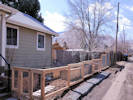
| 
Section 1 painted and moved into place. | Photographed 11 April 2023.
Article records that use this photograph:
images/20230411_162102sm.jpg
| 
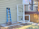
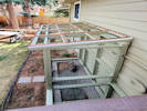
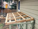
Starting to frame the roof. | Photographed 23 April 2023.
Article records that use this photograph:
images/20230423_170822sm.jpg
| 
Section 1 framed. | Photographed 9 April 2023.
Article records that use this photograph:
images/20230409_151002sm.jpg
| 
Purlins installed, now blocking between the purlins. | Photographed 24 April 2023.
Article records that use this photograph:
images/20230424_170946sm.jpg
| 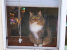
Solny watches from the window. | Photographed 7 April 2023.
Article records that use this photograph:
images/20230407_160154sm.jpg
| 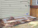
Moved the rock and completed the outline of pavers. | Photographed 7 April 2023.
Article records that use this photograph:
images/20230407_160133sm.jpg
| 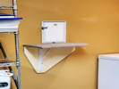
Added the shelf inside. | Photographed 6 April 2023.
Article records that use this photograph:
images/20230406_160759sm.jpg
| 
All the plants moved, but not the rock yet. | Photographed 3 April 2023.
Article records that use this photograph:
images/20230403_154344sm.jpg
| 
Section 1 frame primed. | Photographed 10 April 2023.
Article records that use this photograph:
images/20230410_162544sm.jpg
| 
First coat of paint on the roof framing, 28 Apr 2023. | Photographed 28 April 2023.
Article records that use this photograph:
images/20230428_160520sm.jpg
| 
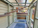
How do I get out of here? | Photographed 30 April 2023.
Article records that use this photograph:
images/20230430_170901sm.jpg
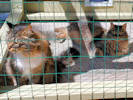
| 
Solny and Myshka, first time in the full enclosure. | Photographed 30 April 2023.
Article records that use this photograph:
images/20230430_170549sm.jpg
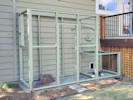
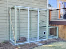
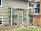
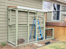
| 
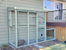
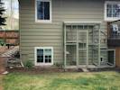
Catio enclosure complete (4/30/2023). | Photographed 30 April 2023.
Article records that use this photograph:
images/20230430_170319sm.jpg
| 
Solny on the upper shelf. | Photographed 2 May 2023.
Article records that use this photograph:
images/20230502_153913sm.jpg
| 
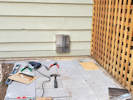
View from the deck of the polycarbonate sheet supports. | Photographed 29 April 2023.
Article records that use this photograph:
images/20230429_171007sm.jpg
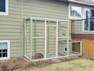
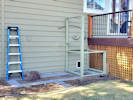
| 
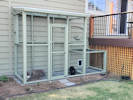
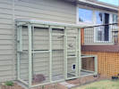
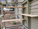
Finished enclosure with a few temporary shelves. | Photographed 2 May 2023.
Article records that use this photograph:
images/20230502_163019sm.jpg
| 
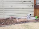
Putting the landscaping back together. | Photographed 4 May 2023.
Article records that use this photograph:
images/20230504_152848sm.jpg
| 
Roof frame painted, corrugated supports installed. | Photographed 29 April 2023.
Article records that use this photograph:
images/20230429_170731sm.jpg
| 
Roof on 27 April 2023, before priming. | Photographed 27 April 2023.
Article records that use this photograph:
images/20230427_150823sm.jpg
| 
Plants moved to new position. | Photographed 2 April 2023.
Article records that use this photograph:
images/20230402_155427sm.jpg
| 
Finished enclosure with a few temporary shelves. | Photographed 2 May 2023.
Article records that use this photograph:
images/20230502_163039sm.jpg
| 
Bare shelves inside the enclosure. | Photographed 2 May 2023.
Article records that use this photograph:
images/20230502_163111sm.jpg
| 
Catio on 27 April 2023 | Photographed 27 April 2023.
Article records that use this photograph:
images/20230427_150751sm.jpg
| 
Myshka figured out how to jump up on the 2x4. | Photographed 30 April 2023.
Article records that use this photograph:
images/20230430_171220sm.jpg
| 
Purlins installed, now blocking between the purlins. | Photographed 24 April 2023.
Article records that use this photograph:
images/20230424_170906sm.jpg
| 
Different view (29 Apr 2023). | Photographed 29 April 2023.
Article records that use this photograph:
images/20230429_170754sm.jpg
| 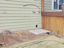
Outside tunnel portal installed. | Photographed 29 March 2023.
Article records that use this photograph:
images/20230329_160153sm.jpg
| 
Tunnel cut through siding. | Photographed 29 March 2023.
Article records that use this photograph:
images/20230329_141802sm.jpg
| 
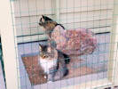
Inside of catio with new covered shelf and pine log. | Photographed 17 May 2023.
Article records that use this photograph:
images/20230517_153815sm.jpg
| 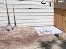
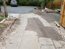
Concrete pavers in place, plants not moved yet. | Photographed 29 March 2023.
Article records that use this photograph:
images/20230329_120348sm.jpg
| 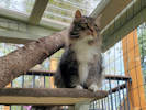
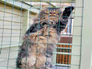
Solny on the new top shelf, accessed by the pine branch. | Photographed 16 May 2023.
Article records that use this photograph:
images/20230516_161131sm.jpg
| 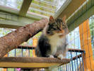
Solny on the new top shelf, accessed by the pine branch. | Photographed 16 May 2023.
Article records that use this photograph:
images/20230516_161130sm.jpg
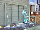
| 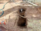
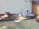
Step 1. Move the sprinklers and landscaping. | Photographed 21 March 2023.
Article records that use this photograph:
images/20230321_125123sm.jpg
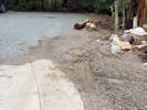
| 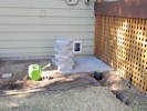
Four foot block of pavers; plants moved. | Photographed 1 April 2023.
Article records that use this photograph:
images/20230401_155204sm.jpg
| 
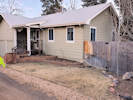
The catio on 13 April 2023. | Photographed 13 April 2023.
Article records that use this photograph:
images/20230413_165811sm.jpg
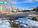
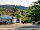
| 5th and Arapahoe
| 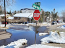
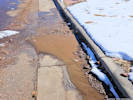
Clogged up storm drain at 5th and Arapahoe | Photographed 18 March 2021.
Article records that use this photograph:
images/20210318_133518sm.jpg
| 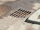
The vault in the storm drain is full again. | Photographed 28 April 2023.
Article records that use this photograph:
images/20230428_130913sm.jpg
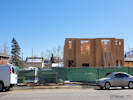
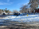
| 5th Street
| 
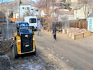
Construction in the alley. | Photographed 1 Sep 2021.
Article records that use this photograph:
images/20210903_102200sm.jpg
| 
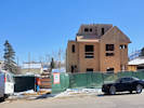
First floor under construction. | Photographed 30 January 2022.
Article records that use this photograph:
images/20220130_134850sm.jpg
| 
What we are about to lose when construction starts. | Photographed 12 August 2021.
Article records that use this photograph:
images/20210812_172737sm.jpg
| 
Construction progress, 14 Feb 2022. | Photographed 14 February 2022.
Article records that use this photograph:
images/20220214_125933sm.jpg
| 
Construction progress, 126 Feb 2022. | Photographed 26 February 2022.
Article records that use this photograph:
images/20220226_140554sm.jpg
| 
Starting to show the duplexes to prospective buyers. | Photographed 22 June 2022. Not on Zillow yet.
images/20220622_103423sm.jpg
| 5th Street and Arapahoe Street
| 
Uncleared snow and ice at 5th and Arapahoe. | Photographed 15 January 2022.
Article records that use this photograph:
images/20220115_141142sm.jpg
| 
Plugged storm drain at 5th and Arapahoe | Photographed 15 January 2022.
Article records that use this photograph:
images/20220115_141102sm.jpg
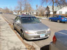
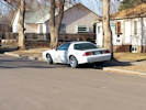
| Abandoned Vehicles
| 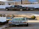
Pickup truck that hasn't moved for a long time. | Photographed 12 February 2017. The jack and jack stand under the truck suggests that it is disabled and cannot be moved.
Article records that use this photograph:
images/20170212_151208sm.jpg
| 
"For Sale" van stored on street for months. | Photographed 27 February 2017.
Article records that use this photograph:
images/20170227_110152sm.jpg
| 
Abandoned vehicle on Arapahoe Street. | Photographed 27 February 2017. This car had not moved for months. It has one of those fake mini-spares on the right front which is nearly flat.
Article records that use this photograph:
images/20170227_105905sm.jpg
| 
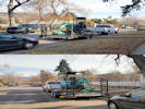
Trailer stored on 3rd Street near Arapahoe Street. | Photographed 12 February 2017.
Article records that use this photograph:
images/20170212_151403sm.jpg
| 
Car parked on curb; thought to be abandoned. | Photographed 12 February 2017.
Article records that use this photograph:
images/20170212_151637sm.jpg
| 
Broken-down construction equipment stored on Arapahoe Street from about a week. | Photographed 12 February 2017.
Article records that use this photograph:
images/20170212_151749sm.jpg
| 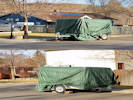
Trailer stored on street for at least 4 months. | Photographed 12 February 2017.
Article records that use this photograph:
images/20170212_151300sm.jpg
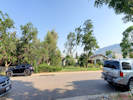
| Apex Park
| 
Boundary between Apex Park and Stonebridge HOA | Photographed 10 June 2022.
Location records that use this photograph:
Article records that use this photograph:
images/20220610_100621sm.jpg
| 
Boundary between Apex Park and Stonebridge HOA | Photographed 10 June 2022.
Location records that use this photograph:
Article records that use this photograph:
images/20220610_102156sm.jpg
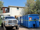
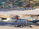
| Arapahoe Street
| 
Alley after passage of the sewer cleanout truck. | Photographed 15 May 2023.
Article records that use this photograph:
images/20230515_120639sm.jpg
| 
Muddy water on its way to Clear Creek from the alley. | Photographed 13 February 2024.
Article records that use this photograph:
images/20240213_131352sm.jpg
| 
Alley after passage of the sewer cleanout truck. | Photographed 15 May 2023.
Article records that use this photograph:
images/20230515_120743sm.jpg
| 
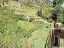
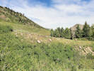
Location of measured cross-section. | Photographed 16 May 2023.
Article records that use this photograph:
images/20230516_103720sm.jpg
| 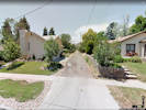
Condition of the alley in June 2012. | Google image capture June 2012.
Article records that use this photograph:
images/420_Arapahoe_St_Image_sm.jpg
| 
The sewer cleanout truck down at the gulch. | Photographed 15 May 2023.
Article records that use this photograph:
images/20230515_110432sm.jpg
| 
“Front” yard before landscaping. | Photographed 3 February 2021.
Article records that use this photograph:
images/20210203_105110sm.jpg
| 
Removing the frozen lawn. | Photographed 24 February 2021.
Article records that use this photograph:
images/20210224_080823sm.jpg
| 
“Front” yard after landscaping. | Photographed 11 March 2021.
Article records that use this photograph:
images/20210311_110312sm.jpg
| 
Old Power Pole | Photographed 2 June 2021.
Article records that use this photograph:
images/20210602_073548sm.jpg
| 
New Power Pole | Photographed 2 June 2021.
Article records that use this photograph:
images/20210602_124924sm.jpg
| 
“Front” yard after landscaping. | Photographed 11 March 2021.
Article records that use this photograph:
images/20210311_110238sm.jpg
| 
“Front” yard before landscaping. | Photographed 3 February 2021.
Article records that use this photograph:
images/20210203_105045sm.jpg
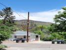
| Bachman Ranch
| 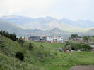
The new boxes on the Bachman Ranch stand out. | Photographed 23 May 2018.
Article records that use this photograph:
images/IMG50231sm.jpg
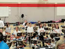
| Bell Middle School
| 
Orchestra concert with Sofia. | Photographed 20 November 2019.
Article records that use this photograph:
images/20191120_184034sm.jpg
| 
Orchestra concert with Sofia. | Photographed 20 November 2019.
Article records that use this photograph:
images/20191120_184936sm.jpg
| 
Orchestra concert with Sofia. | Photographed 20 November 2019.
Article records that use this photograph:
images/20191120_181841sm.jpg
| | |||||||||||||