
Unclassified
Geography - Idaho
Geography - Park County, CO
Geography - Summit County, CO
Geography - Arizona
Geography - British Columbia
Geography - California
Geography - California's Colorado Desert
Alaska
Geography - Mono Lake Basin, California
Geography - Mono County, California
Geography - San Luis Obispo County, California
Geography - Marin County, California
Geography - Santa Clara County
Alameda
Garden
Geography - Central Mojave
Geography - New Mexico
Geography - Eastern Mojave
Geography - Northern Mojave
Geography - Colorado
Geography - Alamosa County, CO
Geography - Boulder County, CO
Geography - Clear Creek County, CO
Geography - Chaffee County, CO
Geography - Douglas County, CO
Geography - Gilpin County, CO
Geography - Golden, Colorado
Geography - Weld County, CO
Geography - Hinsdale County, CO
Geography - Jefferson County, CO
Geography - North Table Mountain, Jefferson Cty, CO
Geography - Lake County, CO
Geography - Larimer County, CO
Geography - Nevada
Geography - Oregon
Geography - Utah
Geography - Virginia
Geography - Washington
Geography - Wyoming
Spain - Andalucia
Spain - Castilla y Leon
Spain - Castilla-La Mancha
Spain - Extremadura
Spain - Galicia
Spain - Madrid
Portugal
Geology
Economic Geology
Climatology
Botany
Salvia dorrii
Frasera albomarginata
Species
Species - Polygonaceae
Species - Brassicaceae
Species - Brassicaceae, Physaria vitulifera
Species - Rosaceae
Species - Fabaceae
Species - Onagraceae
Species - Polemoniaceae
Species - Boraginaceae
Species - Plantaginaceae
Species - Asteraceae
Species - Poaceae
Zoology
Ecology
Archeology
Customer Satisfaction
General
Arizona
California
Kansas
Missouri
Nebraska
New York
Christmas 2002
Family Photos
Family Documents
Family Photos 2003
Art of Lydia Schweich
Portraits
Railroad
Geography - Germany
|
Images are organized by the topics listed at left. Click on a topic name to see images with that topic.
Would you like to use these photographs in your school term paper or report?
License is hereby granted for non-commercial use of the images
contained herein provided that the images are reproduced with the copyright
notice intact. This means that we give you our permission to use the
photographs and information you find here in your school term papers and
reports. You may resize the photograph to fit your needs, but you may not remove the copyright. Your term paper should note that the photographs are reproduced
with permission and it should have a reference to this web site, such as:
"Photograph ©1999 Tom Schweich. Used by permission,
http://www.schweich.com"
If you have a comment or a question about a photograph you may write to me at
tas4@schweich.com
I will answer you as soon as I can.
I sometimes post interesting questions in my FAQ, but I will not disclose your full name or address.
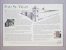
Fort Saint Vrain
|
|
Interpretive plaque at Fort Saint Vrain.
Photographed 10 November 2016.
|
Fort Saint Vrain
In November 1836, the Bent brothers and Ceran St. Vrain received a license authorizing them to trade on the South Platte.
The main business at Fort Lookout, as it was first named, was trading trinkets and beads for buffalo hides and tongues and beaver pelts,
and accommodating passing mountain men.
Fort Lookout was renamed Fort George in honor of George Bent,
one of theBent brothers; However, this fort was generally known as St. Vrains Fort or Fort St. Vrain.
Fort St. Vrain was located one mile north of St. Vrain Creek on the wast side of the South Platte River, on the “Trapper's” or Taos Trail,
which ran from Fort Taos, New Mexico, past Bent's Fort in Colorado to
Fort Laramie in Wyoming.
Fort St. Vrain was said to be exactly halfway between Bent's Fort and Fort Laramie.
During the years it operated as a trading post, St. Vrain's Fort served as a waystation and provisioning point for travelers.
The Fort's history includes a stopover on July 4, 1843 by John Charles Fremont's second xpedition to the Rocky Mountain area.
In the party were Kit Carson and William Gilpin, later governor of Colorado.
With Fort St. Vrain's mission accomplished and with the rapid decline of the fur trade,
the Bent & St. Vrain Company ended its operation of the fort in 1845.
The lure of gold in 1858-59 dramatically increased the regions population.
A booklet, Guide to the Gold Regions of Kansas and Nebraska by Wm. Byers and Jonathon Kellom, encouraged prospectors to seek their fortunes in the
“Eldorado of the South Platte.”
Byers, a land developer came to Cherry Creek and was elected Territorial Surveyor.
He and others hoped Congress woul approve a new “Jefferson”
formed from parts of western Kansas and Nebraska and eastern Utah and
southern Wyoming.
On October 6, 1859, Byers and others met at Ft. St. Vrain and formed the St. Vrain Claim Club to record land claims
and establish a St. Vrain County,
town and township in what was then Jefferson Territory
in western Nebraska Territory.
Nebraska Territorial politicians,
hoping to create a new Jefferson Territory,
granted St. Vrain a post office (January 18, 1859).
Later thay year the Jefferson Territorial government
granted a charter (December 7, 1859) for the
Colorado Wagon Road Company to operate a toll road
between St. Vrain and Golden City.
A wooden toll bridge was also constructed.
Andrew Lumrey, the second post-master at St. Vrain built a one-room
cabin of cottonwood logs circa 1861-1863.
this structure, not at Centennial Village Museum in Greeley, Colorado,
served as the first courthouse in Weld County,
after Colorado Territory was designated in February 1862.
The plat of St. Vrain included the original trading post and
five street named after traders and tribes associated with the fort
— Ceran, Robidoux, Sarpy, Cheyenne, and Kiowa.
Between 1862 – 1864, the Overland Stage Company used Ft. St. Vrain
and the other two Forts as stations on it's (sic)
“Mountain Route” between Denver and Salt Lake City via Ft. Laramie.
On June 22, 1911, the Centennial State Chapter Daughters of the American Revolution installed a granite monument which remains today as the lone sentinel of a proposed town of 420 blocks.
On September 23, 1952, the land deed of Ft. St. Vrain was presented to the Weld County Commissioners.
100th Anniversary Celebration of the marking of the Fort St. Vrain Monument in conjunction with Weld County Colorado's 150th Anniversary Celebration,
September 17, 2011.
Thanks to Noble Energy; Weld County Commissioners; The Town of Milliken;
Platteville Historical Society; The FOur Forts Tour; and Centennial State Chapter, NSDAR.
Information on signs provided by: Joe Pinner & Peggy Ford-Waldo.
|
Location records that use this photograph:
Article records that use this photograph:
images/IMGQ3388sm.jpg
|
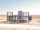
Monument at historic Fort Saint Vrain
Photographed 10 November 2016.
Location records that use this photograph:
Article records that use this photograph:
images/IMGQ3390sm.jpg
|
Interpretive plaque at Fort Saint Vrain.
Photographed 10 November 2016.
|
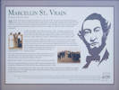
?MARCELLIN ST. VRAIN
Manager of Fort St. Vrain
Marcellin St. Vrain was born at Spanish Lake, Missouri, on October 14, 1815.
He was the tenth and last child of Jacques Marcellin Ceran de Hault de Lassus de St. Vrain and Marie Felicite Dubreuil.
After attending a Jesuit college in St. Louis in 1835, he went to Bent's Fort where he worked for his older brother, Ceran, of the Bent & St. Vrain Company. He learned how to manage the fort and about the fur trade.
In 1837 he was put in charge of St. Vrain's Fort when it was still under
construction.
In 1840 , he married a 13 year old woman known as "Red."
According to verbal St. Vrain Family history,
Red was the sister of the great Chief Red Cloud of the Ogalala Sioux and a
niece of Chief Crazy Horse.
Marcellin and Red had three children, all born at the fort.
Felix born June 17, 1842, Charles born October 17, 1844 and Mary Louise born March 9, 1846.
Some accounts show that in 1845 Fort St Vrain was closed by the Bent & St Vrain Company
and Marcellin moved back to Bent's Fort briefly.
But, if so, he apparently returned to the fort
and ran it on his own soon after.
Later the same year, Marcellin moved to St. Louis. He left Red
and their children under the protection of his older brother Ceran St. Vrain. For several years Red
believed Marcellin would return to her, unknown to her
at first, in 1849 he married Elizabeth Jane Murphy of
Florissant. Missouri.
It is unclear whether Marcellin ever returned west.
However, he sent for his two sons about 1851.
Mary Louise stayed behind with her mother.
Red took Mary Louise to Mora, New Mexico where she married William A. Branford.
Marcellin died on March 3, 1871.
He was buried in Salem Cemetery in Center, MO.
Mary Louise married John Skelly on October 30, 1863 in Mora, New Mexico and had
two children.
Mr. Skelly died in 1879. Mrs. W.A. Branford (Red) died April 12, 1886.
In 1890, Mary Louise married General E.B. Sopris.
Later, at the Generals request, the last names of her children were changed
to Sopris.
Mary Louise, her daughter and grandson, attended the dedication of the monument to Fort St. Vrain in 1911.
Mary Louise died on February 14, 1916.
100th Anniversary Celebration of the marking of the Fort St. Vrain Monument in conjunction with Weld County Colorado's 150th Anniversary Celebration September 17, 2011.
Thanks to Noble Energy; Weld County Commissioners; The Town of Milliken; Platteville Historical Society; The Four Forts Tour and Centennial State Chapter, NSDAR.
Information on signs provided by: Joe Pinner & Peggy Ford-Waldo.
|
Location records that use this photograph:
Article records that use this photograph:
images/IMGQ3386sm.jpg
Greeley
|
|
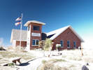
Poudre River Education Center
Photographed 10 November 2016.
Article records that use this photograph:
images/IMGQ3394sm.jpg
|
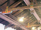
Folk art decoration on ceiling beams.
Photographed 10 November 2016.
Location records that use this photograph:
Article records that use this photograph:
images/IMGQ3409sm.jpg
|
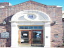
Front door to the Greeley Depot
Photographed 10 November 2016.
One of the interpretive panels outside says this about the depot.
?
|
GREELEY UNION PACIFIC RAILROAD DEPOT
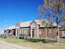
The Greeley Union Pacific Railroad Depot was designed
by architect Gilbert Stanley Underwood and built in 1930.
During the dedication ceremony, Union Pacific President Carl
Gray said, "There is not much economic justification for the building of this station… This expenditure shows in a measure the appreciation of the railroad for the cooperation and aid this community has given the Union Pacific."
The building features terra cotta trim on the four main entrances and grouped,
central double-hung windows on the east and west elevations.
Inside, stenciled folk art images of
animals and designs decorate the ceiling beams.
The building was listed on the National
Register of Historic Places in 1993.
Greeley's link to the outside world was through a series of four depots. During the city's first
year, passengers made do with a boxcar as a depot.
In 1871, a modest board and batten
tructure greeted distinguished visitors such as Horace Greeley and P.T. Barnum.
In 1883, a stone depot was built near the site of the current depot.
Finally, the existing structure was built in 1930 as a result of the efforts of many Greeley residents,
including Chamber of Commerce president Thomas Welsh, who believed that transportation
"is and always has been the dominant factor in city growth."
|
Location records that use this photograph:
Article records that use this photograph:
images/IMGQ3396sm.jpg
|
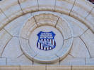
Union Pacific shield on Greeley depot.
Photographed 10 November 2016.
Location records that use this photograph:
Article records that use this photograph:
images/IMGQ3414sm.jpg
|
The Greely depot.
Photographed 10 November 2016.
Location records that use this photograph:
Article records that use this photograph:
images/IMGQ3410sm.jpg
|
|
[Home Page]
Date and time this article was prepared:
5/10/2024 11:14:58 AM
| | | | | | | | | |
