
Eastern Mojave Vegetation
By Tom Schweich
|
Eastern Mojave Vegetation | Images -- Geography - Park County, CO |
|
By Tom Schweich |
|

Unclassified Geography - Idaho Geography - Park County, CO Geography - Summit County, CO Geography - Arizona Geography - British Columbia Geography - California Geography - California's Colorado Desert Alaska Geography - Mono Lake Basin, California Geography - Mono County, California Geography - San Luis Obispo County, California Geography - Marin County, California Geography - Santa Clara County Alameda Garden Geography - Central Mojave Geography - New Mexico Geography - Eastern Mojave Geography - Northern Mojave Geography - Colorado Geography - Alamosa County, CO Geography - Boulder County, CO Geography - Clear Creek County, CO Geography - Chaffee County, CO Geography - Douglas County, CO Geography - Gilpin County, CO Geography - Golden, Colorado Geography - Weld County, CO Geography - Hinsdale County, CO Geography - Jefferson County, CO Geography - North Table Mountain, Jefferson Cty, CO Geography - Lake County, CO Geography - Larimer County, CO Geography - Nevada Geography - Oregon Geography - Utah Geography - Virginia Geography - Washington Geography - Wyoming Spain - Andalucia Spain - Castilla y Leon Spain - Castilla-La Mancha Spain - Extremadura Spain - Galicia Spain - Madrid Portugal Geology Economic Geology Climatology Botany Salvia dorrii Frasera albomarginata Species Species - Polygonaceae Species - Brassicaceae Species - Brassicaceae, Physaria vitulifera Species - Rosaceae Species - Fabaceae Species - Onagraceae Species - Polemoniaceae Species - Boraginaceae Species - Plantaginaceae Species - Asteraceae Species - Poaceae Zoology Ecology Archeology Customer Satisfaction General Arizona California Kansas Missouri Nebraska New York Christmas 2002 Family Photos Family Documents Family Photos 2003 Art of Lydia Schweich Portraits Railroad Geography - Germany |
Images are organized by the topics listed at left. Click on a topic name to see images with that topic. Would you like to use these photographs in your school term paper or report? License is hereby granted for non-commercial use of the images contained herein provided that the images are reproduced with the copyright notice intact. This means that we give you our permission to use the photographs and information you find here in your school term papers and reports. You may resize the photograph to fit your needs, but you may not remove the copyright. Your term paper should note that the photographs are reproduced with permission and it should have a reference to this web site, such as: "Photograph �1999 Tom Schweich. Used by permission, http://www.schweich.com" If you have a comment or a question about a photograph you may write to me at tas4@schweich.com I will answer you as soon as I can. I sometimes post interesting questions in my FAQ, but I will not disclose your full name or address.
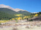
| Boreas Pass Road
| 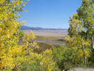
South Park from Boreas Pass Road | Photographed 19 Sep 2016.
Location records that use this photograph:
Article records that use this photograph:
images/IMGQ3350sm.jpg
| 
Aspens along Boreas Pass Road. | Photographed 19 Sep 2016.
Article records that use this photograph:
images/IMGQ3348sm.jpg
| Como
| 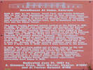
Interpretive sign for Como Roundhouse | Photographed 19 Sep 2016.
Location records that use this photograph:
Article records that use this photograph:
images/IMGQ3339sm.jpg
| 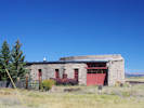
The roundhouse in Como. | Photographed 19 Sep 2016.
Location records that use this photograph:
Article records that use this photograph:
images/IMGQ3341sm.jpg
| 
Como | Photographed 19 Sep 2016.
Location records that use this photograph:
Article records that use this photograph:
images/IMGQ3343sm.jpg
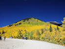
| Kenosha Pass
| 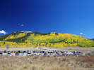
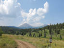
The "scene" at Kenosha Pass | Photographed Monday 19 Sep 2016.
Location records that use this photograph:
Article records that use this photograph:
images/IMGQ3331sm.jpg
| 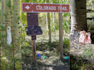
How Coloratans decorate their trailheads! | Photographed Monday 19 Sep 2016.
Location records that use this photograph:
Article records that use this photograph:
images/IMGQ3336sm.jpg
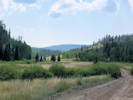
| 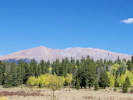
Mount Evans (?) from Kenosha Pass. | Photographed 19 Sep 2016. I think the little white dot on the right-hand shoulder is the observatory at Mount Evans.
Location records that use this photograph:
Article records that use this photograph:
images/IMGQ3337sm.jpg
| Roberts Cabin at Peabodys
| 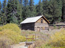
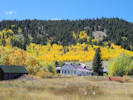
Roberts Cabin at Peabodys | Photographed 19 Sep 2016. R oberts Cabin is located on what is historically known as the Peabody Site. Although associated with the Fred Roberts Claim, perhaps the Peabodys' were more well known for having several additional claims and later another ranch in the Como vicinity. After construction of the railroad over Boreas in 1882, the site became known as Peabody Siding.
Location records that use this photograph:
Article records that use this photograph:
images/IMGQ3346sm.jpg
| 
View northwest up North Tarryall Creek from Roberts Cabin at Peabodys. | Photographed 19 Sep 2016.
Location records that use this photograph:
Article records that use this photograph:
images/IMGQ3347sm.jpg
| Salt Creek
| 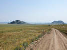
(Valley of) Salt Creek | Photographed 16 August 2021. Salt Creek is out of view on the left; it passes from the left edge of the photo to between the two hills and into Antero Reservoir. US Hwy 285 is in front of the two buttes. Salt Works Ranch is between the two hills. Antero Reservoir is in the left distance.
Location records that use this photograph:
Article records that use this photograph:
images/20210816_111758sm.jpg
| 
Valley of Salt Creek, looking toward Antero Reservoir. | Photographed 18 Jul 2022.
Location records that use this photograph:
Article records that use this photograph:
images/20220718_113406sm.jpg
| 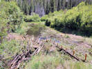
Artificial beaver ponds constructed on Salt Creek. | Photographed 18 Jul 2022.
Location records that use this photograph:
Article records that use this photograph:
images/20220718_144344sm.jpg
| 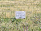
State Land Trust sign on fence along Forest Road 435 “Salt Creek Road.” | Photographed 17 July 2023.
Location records that use this photograph:
Article records that use this photograph:
images/20230717_100040sm.jpg
| 
Junction of Forest Roads 436 and 436.1A. | Photographed 16 August 2021.
Location records that use this photograph:
Article records that use this photograph:
images/20210816_143019sm.jpg
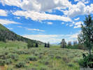
| 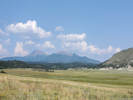
(Valley of) Salt Creek with Buffalo Peaks in the distance. | Photographed 16 August 2021.
Location records that use this photograph:
Article records that use this photograph:
images/20210816_111804sm.jpg
| 
Junction of Forest Roads 435 and 436. | Photographed 16 August 2021.
Location records that use this photograph:
Article records that use this photograph:
images/20210816_142609sm.jpg
|
| Date and time this article was prepared: 5/10/2024 11:14:52 AM | ||||||||||