
Eastern Mojave Vegetation
By Tom Schweich
|
Eastern Mojave Vegetation | Images -- Geography - Oregon |
|
By Tom Schweich |
|

Unclassified Geography - Idaho Geography - Park County, CO Geography - Summit County, CO Geography - Arizona Geography - British Columbia Geography - California Geography - California's Colorado Desert Alaska Geography - Mono Lake Basin, California Geography - Mono County, California Geography - San Luis Obispo County, California Geography - Marin County, California Geography - Santa Clara County Alameda Garden Geography - Central Mojave Geography - New Mexico Geography - Eastern Mojave Geography - Northern Mojave Geography - Colorado Geography - Alamosa County, CO Geography - Boulder County, CO Geography - Clear Creek County, CO Geography - Chaffee County, CO Geography - Douglas County, CO Geography - Gilpin County, CO Geography - Golden, Colorado Geography - Weld County, CO Geography - Hinsdale County, CO Geography - Jefferson County, CO Geography - North Table Mountain, Jefferson Cty, CO Geography - Lake County, CO Geography - Larimer County, CO Geography - Nevada Geography - Oregon Geography - Utah Geography - Virginia Geography - Washington Geography - Wyoming Spain - Andalucia Spain - Castilla y Leon Spain - Castilla-La Mancha Spain - Extremadura Spain - Galicia Spain - Madrid Portugal Geology Economic Geology Climatology Botany Salvia dorrii Frasera albomarginata Species Species - Polygonaceae Species - Brassicaceae Species - Brassicaceae, Physaria vitulifera Species - Rosaceae Species - Fabaceae Species - Onagraceae Species - Polemoniaceae Species - Boraginaceae Species - Plantaginaceae Species - Asteraceae Species - Poaceae Zoology Ecology Archeology Customer Satisfaction General Arizona California Kansas Missouri Nebraska New York Christmas 2002 Family Photos Family Documents Family Photos 2003 Art of Lydia Schweich Portraits Railroad Geography - Germany |
Images are organized by the topics listed at left. Click on a topic name to see images with that topic. Would you like to use these photographs in your school term paper or report? License is hereby granted for non-commercial use of the images contained herein provided that the images are reproduced with the copyright notice intact. This means that we give you our permission to use the photographs and information you find here in your school term papers and reports. You may resize the photograph to fit your needs, but you may not remove the copyright. Your term paper should note that the photographs are reproduced with permission and it should have a reference to this web site, such as: "Photograph �1999 Tom Schweich. Used by permission, http://www.schweich.com" If you have a comment or a question about a photograph you may write to me at tas4@schweich.com I will answer you as soon as I can. I sometimes post interesting questions in my FAQ, but I will not disclose your full name or address.
| 137� Sunshine Acres Drive
| 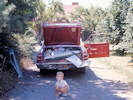
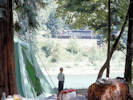
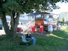
Getting ready to go camping. | Scanned in 2023 from a slide stamped AUG 70.
Article records that use this photograph:
images/1970-08-21-img493sm.jpg
| 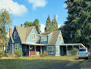
The converted garage we lived in, 1969-1971. | Photographed 28 September 2022.
Article records that use this photograph:
images/20220928_131118sm.jpg
| 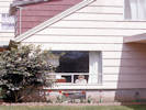
Matt in the window. | Scanned in 2023 from a slide stamped AUG 70.
Article records that use this photograph:
images/1970-08-14-img506sm.jpg
| 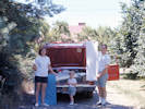
Ready to go camping | Scanned in 2023 from a slide stamped AUG 70.
Article records that use this photograph:
images/1970-08-22-img503sm.jpg
| 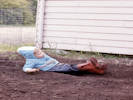
"Karum-bee!" � Matt flopping down in the garden. | Scanned in 2023 from a slide stamped AUG 70, though I think more likely this photo was taken in May or June.
Article records that use this photograph:
images/1970-08-12-img501sm.jpg
| 
Working in the garden. | Scanned in 2023 from a slide stamped AUG 70.
Article records that use this photograph:
images/1970-08-9-img495sm.jpg
| 
Matt in the garden. | Scanned in 2023 from a slide stamped AUG 70.
Article records that use this photograph:
images/1970-08-28-img492sm.jpg
| 
"Karum-bee!" � Matt flopping down in the garden. | Scanned in 2023 from a slide stamped AUG 70, though I think more likely this photo was taken in May or June.
Article records that use this photograph:
images/1970-08-img491sm.jpg
| 
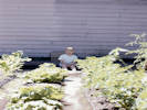
Matt in the soon-to-be garden. | Scanned in 2023 from a slide stamped AUG 70. I think this photo was taken in early June, given the status of the garden.
Article records that use this photograph:
images/1970-08-15-img500sm.jpg
| Black Canyon Campground
| 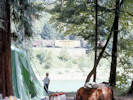
Matt watches a train go by. | Scanned in 2023 from a slide stamped AUG 70.
Article records that use this photograph:
images/1970-08-img488sm.jpg
| 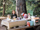
Cheryl and Matt at dinner. | Scanned in 2023 from a slide stamped AUG 70.
Article records that use this photograph:
images/1970-08-24-img504sm.jpg
| 
Matt watches the lead engine go by. | Scanned in 2023 from a slide stamped AUG 70.
Article records that use this photograph:
images/1970-08-25-img505sm.jpg
| Clatsop County
| 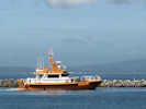
Pilot leaves Hammond harbor, Oregon. | Photograph taken 17 Sept 2009. Hammond is downriver from Astoria, and transfers bar pilots to and from the big ships as far as 10 to 15 miles out in the ocean during stormy weather or calm. The bar of the Columbia River is one of the most treacherous river bars in the world, and some call it the most treacherous. Piloting the ships across the bar is a specialty occupation, and the pilots have to understand not only the tides, currents, weather, and what lies below the water line at any given level of the tide, but also the capability, draft, and size, of each ship they board.
Article records that use this photograph:
images/IMG02192sm.jpg
| 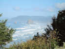
Haystack Rock, off Cannon Beach, Oregon | Photograph taken 17 Sept 2009. Haystack Rock is a 235-foot (72-meter) tall monolith (or sea stack) on the Oregon coast in the northwestern United States, the third-tallest such "intertidal" meaning it can be reached by land, structure in the world. A popular tourist destination, the rock is adjacent to the beach and accessible by foot during low tide. Haystack Rock tide pools are home to many intertidal animals, including starfish, anemone, crabs, chitons, limpets, and sea slugs. The rock is also a refuge for many sea birds, including terns and puffins. Composed of basalt, Haystack Rock was formed by lava flows emanating from the Grand Ronde Mountains 10 to 17 million years ago.
Article records that use this photograph:
images/IMG02180sm.jpg
| 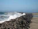
South jetty of Columbia River | Photograph taken 17 Sept 2009. The initial 4.5-mile section of The South Jetty at the mouth of the Columbia River was completed in 1896, with a 2.4-mile extension completed in 1914. Eight subsequent repairs have also been completed (last one in 1982). Jetty stone placement at the South Jetty, to date, totals approximately 8.7 million tons. Approximately 0.8 mile of the outer tip of the jetty has eroded since initial construction and is no longer functional. On Feb. 16, 2006, the Corps awarded a contract for the Mouth of the Columbia River South Jetty Interim Repair to Kiewit Pacific, of Vancouver, Wash. The interim repair contract will last two years with scheduled completion in October 2007. The Corps expects Kiewit to place about 130,000 tons of jetty stone over the 5,300-foot-long repair area on the south jetty. The base contract was awarded to Kiewit for $11.4 million to repair the inland reach of the jetty, which should be completed by October 2006. The second phase of the contract, in which the seaward reach will be repaired, should be completed in 2007. The Corps expects the contractor to place up to 130,000 tons of jetty stone in the two areas that extend over a 5,300-foot-long section on the south jetty.
Article records that use this photograph:
images/IMG02185sm.jpg
| 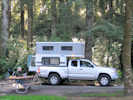
Camper in Fort Stevens State Park, Oregon | Photograph taken 17 Sept 2009. Fort Stevens was the primary military defense installation in the three fort Harbor Defense System at the mouth of the Columbia River (Forts Canby and Columbia in Washington were the other two). The fort served for 84 years, beginning with the Civil War and closing at the end of World War II. Today, Fort Stevens has grown into a 3,700 acre park offering exploration of history, nature, and recreational opportunities.
Article records that use this photograph:
images/IMG02193sm.jpg
| 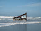
Remains of the Peter Iredale. | Photograph taken 17 Sept 2009. The Peter Iredale was a four-masted steel barque sailing vessel that ran ashore October 25, 1906, on the Oregon coast en route to the Columbia River. It was abandoned on Clatsop Spit near Fort Stevens in Warrenton about four miles (6 km) south of the Columbia River channel. The ship was named after Peter Iredale, who not only owned the vessel as part of his shipping fleet, but was also a well known figure in Liverpool, England, where his business was headquartered. Sailing from Salina Cruz, Mexico, on or about September 26, 1906, the Peter Iredale was bound for Portland, Oregon with 1,000 tons of ballast and a crew of 27, including two stowaways. The voyage up the coast was unremarkable until the night of October 25, when Captain H. Lawrence sighted the Tillamook Rock Lighthouse at 3:20 a.m. local time. The crew altered course first east-northeast and then northeast to enter the mouth of the Columbia River in thick mist and a rising tide. Under strong winds out of the west, an attempt was made to wear the ship away from shore, but a heavy northwest squall grounded the Peter Iredale on Clatsop Sands (now called Clatsop Spit). High seas and wind drove the ship ashore. A lifeboat was dispatched from Hammond, Oregon and assisted in evacuating the sailors, who were tended to at Fort Stevens. No casualties occurred in the accident.
Article records that use this photograph:
images/IMG02181sm.jpg
| Clatsop County, Astoria
| 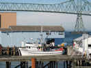
Unloading fish in Astoria, Oregon | Photograph taken 18 Sept 2009. I think this might be: Fishhawk Fisheries, 1 4th St., Astoria, OR 97103. Phone: (503) 325-5252. Fish Packers (Mfrs) in Astoria, O. Whole Fish/Seafood, Seafood Canning. Fishhawk Fisheries is a private company categorized under Fish Packers (Mfrs) and located in Astoria, OR. Records show it was established in 1985 and incorporated in Alaska. Current estimates show this company has an annual revenue of $2.5 to 5 million and employs a staff of approximately 10 to 19.
Article records that use this photograph:
images/IMG02201sm.jpg
| 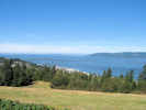
Astoria-Megler Bridge across Columbia River at Astoria, Oregon. | Photograph taken 18 Sept 2009. The Astoria-Megler Bridge, which was formally dedicated August 27, 1966, stretches 4.1 miles from Astoria, Oregon, across the mouth of the Columbia River, to Point Ellice, Washington. Construction work began on November 5, 1962. The bridge�s main span is 1,232 feet in length, the longest �continuous truss� in the world. The Astoria approach utilizes pre-stressed concrete beam spans, set on concrete piers, located to avoid overloading the slide-prone Astoria hills. The approach ramp curves counter-clockwise through a full 360 degrees, climbing almost 200 feet above mean low water. The bridge is designed to withstand some of the toughest attacks of nature, wind gusts of 150 miles per hour from the fierce Pacific storms that occasionally batter the coast still leave the bridge with a safety factor. The concrete piers are built with an eye toward the river flood speed of nine miles per hour when whole trees sometime are swept along by the raging water. From 1921 until the bridge was built, a scheduled ferry ran between Astoria and Megler on the Washington side.
Article records that use this photograph:
images/IMG02202sm.jpg
| 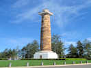
Astoria Column | Photograph taken 18 Sept 2009. The Astoria Column is a tower overlooking the mouth of the Columbia River on Coxcomb Hill in the city of Astoria in the U.S. state of Oregon. Built in 1926, the concrete and steel structure is part of a 30-acre (120,000 m2) city park. The 125-foot (38 m)-tall column has an observation deck at the top and was added to the National Register of Historic Places on May 2, 1974.
Article records that use this photograph:
images/IMG02205sm.jpg
| 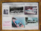
Information board about the Bowpicker Caf e. | Photograph taken 18 Sept 2009.
Article records that use this photograph:
images/IMG02206sm.jpg
| 
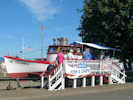
Bowpicker Caf e. | Photograph taken 18 Sept 2009.
Article records that use this photograph:
images/IMG02207sm.jpg
| 
Bowpicker Caf e. | Photograph taken 18 Sept 2009.
Article records that use this photograph:
images/IMG02208sm.jpg
| Coos County
| 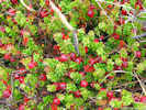
Cranberries along Croft Lake Road. | Photograph taken 14 Sept 2009. Cranberries are grown throughout the United States and Canada. Along the pacific coast, cranberries are grown in Oregon, Washington and British Columbia. In 1915, one of the earliest cranberry bogs in the Bandon area was built on the east side of Muddy Lake by Henry Eden and Dr. Roland Leep. The spruce swamp was cleared by hand, and a steam donkey is connected to a haul back to obtain sand from dunes east of new River. These bogs were hand picked by local women who are hired each fall, and paid in vouchers that can be redeemed at several Bandon businesses. In 1917, Joseph Stankeiwicz, a pioneer cranberry grower in the Croft lake area, crosses the McFarlin cranberry vine with wild vines from a marsh at new lake to create the Stankevich variety.
Article records that use this photograph:
images/IMG02155sm.jpg
| 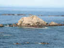
Seals, sea lions, and sea elephants on Simpson Reef, off Cape Arago, Oregon | Photograph taken 14 Sept 2009. Simpson Reef/North Cove Cape Arago is a habitat refuge and priority rock/reef. It is part of the Cape Arago Headland Research Reserve. Simpson Reef is a large seal and sealion haulouts and pupping areas (Steller sea lion, harbor seal, California sea lion, elephant seal); Oregon�s largest, and among its richest rocky intertidal habitats; kelp beds with both Nereocystis and Macrocystis (giant kelp, the largest such bed in the state); rich subtidal reef habitat; three small seabird colony sites; use by brown pelican (threatened species), and a gray whale feeding area. Species include typical intertidal invertebrates and algal species such as: Anthopleura xanthogrammica, Hemigrapsus oregonensis, Littorina sp., various algal species (Mastocarpus papillatus, Fucus sp., Ulva sp., encrusting red/brown algae, bull kelp, pink coralline algae), barnacles (Balanus sp. and Pollicipes polymerus), surfgrass, turban snails, large mussel beds (Mytilus sp.), Pisaster ochraceus, abundant purple urchins, limpets, harbor seals, California sea lions, Stellar sea lions, brown pelicans, and cormorants. Northern elephant seals also use the area as a haulout. One of the few confirmed sightings of a sea otter in Oregon in recent years was at Simpson Reef in 2004.
Article records that use this photograph:
images/IMG02158sm.jpg
| 
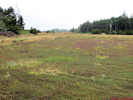
Information about New River ACEC | Photograph taken 14 Sept 2009. New River is a dynamic, ever-changing system influenced by biological, climatological, geo-physical, and fluvial processes. The river and adjacent lands administered by the Bureau of Land Management (BLM) are in a special management category known as the New River Area of Critical Environmental Concern (ACEC). The New River ACEC is managed to maintain biodiversity and quality habitats for native communities of plants, birds, animals, and fish. It also provides protection to cultural sites and affords educational, interpretive, and recreational opportunities to the visiting public in a manner consistent with the primary goals of protecting natural and cultural resources. BLM�s vision of the New River area includes protecting or enhancing habitats for a diversity of wildlife and plant species. Varied ecosystems such as meadows, forests, wetlands, coastal lakes, open sand dunes, and the New River estuary will continue to support this biodiversity. This includes a more stable meandering river with greater riparian vegetation. BLM also envisions a visiting public that will appreciate and enjoy the varied ecosystems protected at New River in a way that will not degrade the naturalness of the setting or the quality of the visitor experience. BLM will manage the ACEC primarily for non-motorized public use that is compatible with the semi-primitive natural setting evident throughout most of the area. In 1983, BLM designated 686 acres of federal lands along New River as an Area of Critical Environmental Concern (ACEC) to protect this unique natural area. In 1989, a land acquisition plan was completed, and over the next eight years, BLM acquired an additional 670 acres of private lands from willing sellers, bringing the current total land base of the ACEC to 1,356 acres. The primary resource values for the New River ACEC include:
Article records that use this photograph:
images/IMG02153sm.jpg
| 
Cranberry bogs along Croft Lake Road. | Photograph taken 14 Sept 2009.
Article records that use this photograph:
images/IMG02154sm.jpg
| 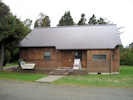
Ellen Warring Learning Center at New River ACEC | Photograph taken 14 Sept 2009. The Ellen Warring Learning Center, dedicated in May 2001, provides a focal point for both interpretation and environmental education at New River. The learning center was designed in part to help meet program needs by providing space for a library and group gatherings, interpretive displays, storage of field equipment used by both naturalists and researchers, and living quarters for people conducting programs and/or research on site.
Article records that use this photograph:
images/IMG02152sm.jpg
| 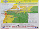
Tsunami Evacuation Map for Bandon, Oregon | Photographed 17 October 2017.
Location records that use this photograph:
Article records that use this photograph:
images/20171018_090305e.jpg
| 
Face Rock | Photographed 17 October 2017.
Location records that use this photograph: Article records that use this photograph:
images/20171018_090421sm.jpg
| 
Location code for use in case of emergency | Photographed 17 October 2017.
Location records that use this photograph:
Article records that use this photograph:
images/20171018_090809e.jpg
| Curry County
| 
Cape Blanco Lighthouse | Photograph taken 14 Sept 2009. The south wind was blowing very strong, and I had to get down behind a dune to take this photo. Cape Blanco Light Station was built on 47.7 acres of land. A two-family dwelling was built for keepers' quarters, with fireplaces in each room for heat. Several small buildings were constructed to house oil and other necessities. Most materials used for construction were shipped in, however, the bricks were made locally. Lt. Col. R.S. Williamson was the engineer of record; he rejected nearly 20,000 of the 200,000 bricks as inferior. Finally, the light station was completed and H. Burnap was hired as the first Keeper. On the eve of December 20, 1870, the Fresnel lens was lit for the first time. This isolated lighthouse holds at least four Oregon records: it is the oldest continuously operating light, the most westerly, it has the highest focal plane above the sea, (256 feet), and Oregon�s first woman keeper, Mabel E. Bretherton signed on in March 1903. James Langlois and James Hughes were Cape Blanco�s most distinguished keepers. (Hughes was the second son of Patrick and Jane Hughes, whose 2,000-acre ranch bordered the Light Station property.) They both served their entire careers at Cape Blanco, Langlois 42 years and Hughes 33 years. The keeper job included keeping the light working from sunset to sunrise. Langlois, Hughes and many other keepers for the Light-House Service diligently kept the lamps burning, and the huge Fresnel lens polished until the U.S. Coast Guard took over in 1939. The station was later automated and abandon in 1979. The last known "keeper," stationed at Cape Blanco for grounds keeping and security purposes, left in December of 1987. In early 1936, the lighthouse was electrified and the actual lens was replaced with an eight side, rotating lens, built in France by Henry-LePaute. The new lens coupled with the speed as it turned, provided a flash of light every 20 seconds. A 1,000-watt incandescent bulb replaced Cape Blanco�s soot producing oil lamps of old. Gone are the keepers who spent hours polishing the magnificent lens and winding the clockworks. Today, it rotates with the help of a 120-volt, 75-rpm electric motor, specially manufactured for lighthouse duty. The electrified light flashes it's 320,000 candlepower beam, 1.8 seconds bright (flash) every 18.2 seconds.
Article records that use this photograph:
images/IMG02148sm.jpg
| 
Plaque for Hughes House | Photograph taken 14 Sept 2009. Closed on Mondays.
Article records that use this photograph:
images/IMG02146sm.jpg
| 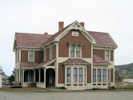
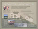
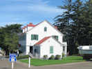
Hughes House | Photograph taken 14 Sept 2009. Closed on Mondays. A fine example of late Victorian architecture, the Hughes ranch house is listed on the National Register of Historic Places. Built in 1898 by P.J. Lindberg, it was a celebration of 38 years of hard work by Patrick and Jane Hughes. The historic Hughes ranch house is a two story, eleven room house solidly framed of 2x8 old growth Port Orford cedar. The rectangular structure with cross axial wings, has over 3,000 square feet, and was constructed in 1898 at a cost for $3,800. The house stands on a terrace on the north side of Cape Blanco. There are vistas of the distant hills, the Pacific Ocean, the Sixes River and the fields above and below. This location protects the house from the worst of the winter southwesters, but northwesters are still frequent visitors.
Article records that use this photograph:
images/IMG02145sm.jpg
| Deschutes County, McKenzie Pass area.
| 
Mount Washington from the McKenzie Pass Highway. | Photographed 28 September 2022.
Location records that use this photograph:
Article records that use this photograph:
images/20220928_095207sm.jpg
| 
McKenzie Pass, elev. 5325 ft. | Photographed 28 September 2022.
Location records that use this photograph:
Article records that use this photograph:
images/20220928_100541sm.jpg
| 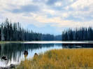
Scott Lake with North and Middle Sister in the distance. | Photographed 28 September 2022.
Location records that use this photograph:
Article records that use this photograph:
images/20220928_105434sm.jpg
| 
Dee Wright Observatory at McKenzie Pass. | Photographed 28 September 2022.
Location records that use this photograph:
Article records that use this photograph:
images/20220928_100938sm.jpg
| Deschutes County, Sisters
| 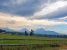
Broken Top and North Sister, from Sisters. | Photographed 28 September 2022.
Location records that use this photograph:
Article records that use this photograph:
images/20220928_093318sm.jpg
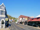
| Dexter
| 
"Near Dexter" | Photographed in Spring 1969, scanned from a slide in 2023.
Article records that use this photograph:
images/1969-03-img381sm.jpg
| 
Dexter Self-Service Laundry | Photographed in November 1968, scanned from a slide in 2023.
Location records that use this photograph:
Article records that use this photograph:
images/1968-11-img380sm.jpg
| Douglas County
| 
Lighthouse keeper's quarters, Umpqua Lighthouse, Oregon. | Photograph taken 15 Sept 2009.
Article records that use this photograph:
images/IMG02162sm.jpg
| 
Mouth of Umpqua River, Oregon | Photograph taken 15 Sept 2009.
Article records that use this photograph:
images/IMG02160sm.jpg
| 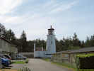
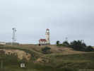
Umpqua Lighthouse, Oregon | Photograph taken 15 Sept 2009. The Umpqua River Lighthouse towers above the entrance to Winchester Bay. The 65-foot tower contains a distinctive lens which emits a red and white flash. The lighthouse and adjacent museum are operated and maintained by the Douglas County Parks Department.
Article records that use this photograph:
images/IMG02161sm.jpg
| Eugene
| 
Pickup truck rodeo at River Road and River Avenue. | Photographed in January 1969, scanned from a slide in 2023.
Article records that use this photograph:
images/1969-01-26-img399sm.jpg
| 
Cheryl and Matt near the intersection of River Avenue and River Road. | Photographed in January 1969, scanned from a slide in 2023.
Article records that use this photograph:
images/1969-01-26-img397sm.jpg
| 
Out on River Avenue after the big snow. | Photographed in January 1969, scanned from a slide in 2023.
Article records that use this photograph:
images/1969-01-26-img395sm.jpg
| 
Swinging at Skinner Butte Park. | Photographed in January 1969, scanned from a slide in 2023.
Location records that use this photograph:
Article records that use this photograph:
images/1969-02-00-img392sm.jpg
| 
Going to the swings at Skinners Butte Park. | Photographed in January 1969, scanned from a slide in 2023.
Location records that use this photograph:
Article records that use this photograph:
images/1969-02-00-img390sm.jpg
| 
River Avenue at the entrance to Riviera Village. | Photographed in January 1969, scanned from a slide in 2023.
Article records that use this photograph:
images/1969-01-26-img390sm.jpg
| 
Mat feeding the ducks. | Scanned in 2023 from a slide stamped AUG 70, though I think more likely this photo was taken in June at the Mill Race near the University. This is not imfamous gazillion duck attack at Dorena Lake.
Article records that use this photograph:
images/1970-08-17-img502sm.jpg
| 
Cheryl and Matt at the intersection of River Road and River Avenue. | Photographed in January 1969, scanned from a slide in 2023.
Article records that use this photograph:
images/1969-01-26-img398sm.jpg
| 
Snow on the house across River Avenue. | Photographed in January 1969, scanned from a slide in 2023.
Article records that use this photograph:
images/1969-01-26-img396sm.jpg
| 
Our car covered with snow. | Photographed in January 1969, scanned from a slide in 2023.
Article records that use this photograph:
images/1969-01-26-img391sm.jpg
| 
View across River Avenue from our apartment at River Avenue. | Photographed in December 1968, scanned from a slide in 2023.
Article records that use this photograph:
images/1968-12-00-img402sm.jpg
| 
Downtown Eugene from Skinner Butte. | Photographed in November 1968, scanned from a slide in 2023.
Location records that use this photograph:
Article records that use this photograph:
images/1968-11-00-img405sm.jpg
| 
Eugene Planning Mill and hardware store. | Photographed in November 1968, scanned from a slide in 2023.
Article records that use this photograph:
images/1968-11-00-img406sm.jpg
| 
Skinner Butte from Hendricks Park (?) | Photographed in November 1968, scanned from a slide in 2023.
Article records that use this photograph:
images/1968-11-00-img408sm.jpg
| 
Mail boxes along River Avenue. | Photographed in January 1969, scanned from a slide in 2023.
Article records that use this photograph:
images/1969-01-26-img484sm.jpg
| 
The Bowl at Eugene, Oregon | Photographed May 1971, scanned from a print 11 February 2018.
Article records that use this photograph:
images/71-16.14-250.jpg
| 
The One-Spot (car repair facility) at Eugene, Oregon. | Photographed May 1971, scanned from a print 11 February 2018.
Article records that use this photograph:
images/71-16.15-250.jpg
| 
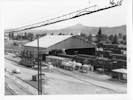
The hump lead at Eugene, Oregon. | Photographed May 1971, scanned from a print 11 February 2018.
Article records that use this photograph:
images/71-16.20-250.jpg
| 
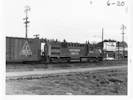
EFCX1165, last car in a hump cut. | Photographed Mar 1971, scanned from a print 17 February 2018.
Article records that use this photograph:
images/713-6-21-300.jpg
| 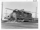
SP 8860 at Eugene locomotive service track | Photographed May 1971, scanned from a print 11 February 2018.
Article records that use this photograph:
images/71-16.06-250.jpg
| 
UP520211, somewhere near Eugene, Oregon. | Photographed Mar 1971, scanned from a print 17 February 2018.
images/713-5-21-300.jpg
| 
SP5160 works the hump at Eugene. | Photographed Mar 1971, scanned from a print 17 February 2018.
Article records that use this photograph:
images/713-6-20-300.jpg
| 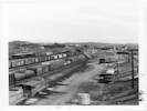
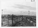
The Receiving Yard at Eugene. | Photographed May 1971, scanned from a print 11 February 2018.
Article records that use this photograph:
images/71-16.16-250.jpg
| Grant County
| 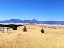
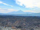
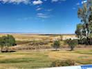
Valley of John Day River | Photographed 3 September 2018.
Article records that use this photograph:
images/20180903_085014sm.jpg
| 
John Day in the morning. | Photographed 3 September 2018.
Location records that use this photograph:
Article records that use this photograph:
images/20180903_082749sm.jpg
| Grant County, John Day Fossil Beds N. M.
| 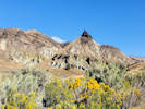
Sheep Rock, across from the Condon Paleontology Center | Photographed 2 October 2022.
Location records that use this photograph:
Article records that use this photograph:
images/20221002_155054sm.jpg
| Harney County, Malheur National Wildlife Refuge
| 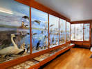
A small portion of the displays in the museum. | Photographed 27 September 2022. I was disappointed there was no display of dildoes left from the Bundy occupation.
Location records that use this photograph:
Article records that use this photograph:
images/20220927_125715sm.jpg
| 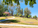
National Wildlife Refuge grounds. | Photographed 27 September 2022.
Location records that use this photograph:
Article records that use this photograph:
images/20220927_124821sm.jpg
| 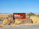
Welcome to Malheur National Wildlife Refuge. | Photographed 27 September 2022.
Location records that use this photograph:
Article records that use this photograph:
images/20220927_133402sm.jpg
| 
Malheur Lake, mostly dry in September. | Photographed 27 September 2022.
Location records that use this photograph:
Article records that use this photograph:
images/20220927_132611sm.jpg
| Lane County
| 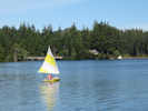
Sailboat on Woahink Lake | Photograph taken 15 Sept 2009. Woahink Lake is located on the central Oregon coast south of the city of Florence and about three miles inland from the Pacific Ocean. Its southern end lies adjacent to US Highway 101, so that it is seen by all travelers on this major arterial. The lake basin owes its origin to the fluctuations in sea level that accompanied the latter stages of the Pleistocene Epoch, alternating periods of submergence and emergence of the coastal zone (Cooper 1958). During periods of submergence, the mouths of coastal streams were inundated by the higher water level. Many small streams lacked the erosive ability to prevent the obstruction of their mouths by sediment impoundments. Woahink Lake, lying on a marine terrace, was formed in this manner. The stream system that was inundated to form the lake basin was probably a tributary of the ancestral Siltcoos River. The water surface of Woahink Lake is 38 feet above mean sea level, and the bottom at its deepest point is 74 feet deep, or about 36 feet below sea level, the lowest of any of the sand-dune dammed lakes on the Oregon coast. Thus, the Woahink Lake basin is a deep, steep-walled cryptodepression.
Article records that use this photograph:
images/IMG02163sm.jpg
| 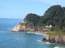
Heceta Head Lighthouse from view point. | Photograph taken 15 Sept 2009.
Article records that use this photograph:
images/IMG02170sm.jpg
| 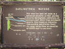
Interpretive sign for Darlingtonia State Wayside | Photograph taken 15 Sept 2009. The Darlingtonia Preserve is located just off Highway 101, north of the town of Florence on the Southern Oregon Coast. The tiny park is centered on a peat bog that hosts an unusual concentration of the carnivorous California pitcher plant, or cobra lily - known by the botanical name Darlingtonia californica. The 18-acre preserve is the only Oregon state park dedicated to the protection of a single plant species. The rare, strangely-shaped Darlingtonia plant is the only member of the pitcher plant family in Oregon. Visitors will discover a large colony of plants with green "cobra" hoods atop 10 to 20-inch hollow tubes that serve as the digestive tract for the cobra lily. As they mature, the hoods develop a mottled purple and red color. A hidden opening into the stalk is bordered by a large, green, moustache-shaped appendage beneath the curved hood of the leaf. Nectar on the "moustache" attracts insects to the plant, and eventually into the hood. Once inside, an insect becomes confused by the transparent areas in the hood that appear to be exits. The insect eventually falls into the lower part of the tube, and is trapped from escaping by downward-pointed hairs until it falls into a pool of water at the bottom of the stalk. Bacteria in the water decomposes insects into nitrogen that is then absorbed by the plant. Darlingtonia californica has purple and yellow flowers that rise above the hooded stalks. The plants are found only in wet meadows and bogs that provide acid soils that are low in nitrogen.
Article records that use this photograph:
images/IMG02164sm.jpg
| 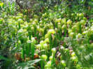
Darlingtonia californica | Photograph taken 15 Sept 2009.
Article records that use this photograph:
images/IMG02165sm.jpg
| Lane County, McKenzie River
| 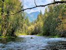
McKenzie River at Jennie B. Harris State Wayside. | Photographed 28 September 2022.
Location records that use this photograph:
Article records that use this photograph:
images/20220928_115704sm.jpg
| Lane County, McKenzie River, Belnap Bridge
| 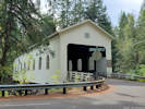
Belnap Bridge on McKenzie River Drive (off the main highway). | Photographed 28 September 2022.
Location records that use this photograph:
Article records that use this photograph:
images/20220928_121114sm.jpg
| Lincoln County, Cape Perpetua
| 
Waiting for the perfect shot at the Captain Cook Trailhead. | Photographed 29 September 2022.
Location records that use this photograph:
Article records that use this photograph:
images/20220929_141120sm.jpg
| 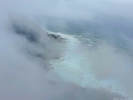
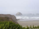
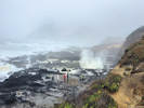
Waves and rocks through the fog. | Photographed 29 September 2022.
Location records that use this photograph:
Article records that use this photograph:
images/20220929_124250sm.jpg
| | |||||||||||||||||||||||||