
Eastern Mojave Vegetation
By Tom Schweich
|
Eastern Mojave Vegetation | Images -- Geography - Eastern Mojave |
|
By Tom Schweich |
|

Unclassified Geography - Idaho Geography - Park County, CO Geography - Summit County, CO Geography - Arizona Geography - British Columbia Geography - California Geography - California's Colorado Desert Alaska Geography - Mono Lake Basin, California Geography - Mono County, California Geography - San Luis Obispo County, California Geography - Marin County, California Geography - Santa Clara County Alameda Garden Geography - Central Mojave Geography - New Mexico Geography - Eastern Mojave Geography - Northern Mojave Geography - Colorado Geography - Alamosa County, CO Geography - Boulder County, CO Geography - Clear Creek County, CO Geography - Chaffee County, CO Geography - Douglas County, CO Geography - Gilpin County, CO Geography - Golden, Colorado Geography - Weld County, CO Geography - Hinsdale County, CO Geography - Jefferson County, CO Geography - North Table Mountain, Jefferson Cty, CO Geography - Lake County, CO Geography - Larimer County, CO Geography - Nevada Geography - Oregon Geography - Utah Geography - Virginia Geography - Washington Geography - Wyoming Spain - Andalucia Spain - Castilla y Leon Spain - Castilla-La Mancha Spain - Extremadura Spain - Galicia Spain - Madrid Portugal Geology Economic Geology Climatology Botany Salvia dorrii Frasera albomarginata Species Species - Polygonaceae Species - Brassicaceae Species - Brassicaceae, Physaria vitulifera Species - Rosaceae Species - Fabaceae Species - Onagraceae Species - Polemoniaceae Species - Boraginaceae Species - Plantaginaceae Species - Asteraceae Species - Poaceae Zoology Ecology Archeology Customer Satisfaction General Arizona California Kansas Missouri Nebraska New York Christmas 2002 Family Photos Family Documents Family Photos 2003 Art of Lydia Schweich Portraits Railroad Geography - Germany |
Images are organized by the topics listed at left. Click on a topic name to see images with that topic. Would you like to use these photographs in your school term paper or report? License is hereby granted for non-commercial use of the images contained herein provided that the images are reproduced with the copyright notice intact. This means that we give you our permission to use the photographs and information you find here in your school term papers and reports. You may resize the photograph to fit your needs, but you may not remove the copyright. Your term paper should note that the photographs are reproduced with permission and it should have a reference to this web site, such as: "Photograph �1999 Tom Schweich. Used by permission, http://www.schweich.com" If you have a comment or a question about a photograph you may write to me at tas4@schweich.com I will answer you as soon as I can. I sometimes post interesting questions in my FAQ, but I will not disclose your full name or address.
| 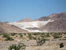
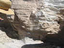
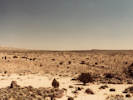
Snowcap Limestone Mine | Photograph taken April 22, 2008. Omya (California) operates the Amboy Limestone quarry located 6 miles east of Amboy, California, in the southern Bristol Mountains. The Amboy Limestone deposit, a very high purity, high brightness (white) crystalline limestone deposit is of such high purity it is suitable for pharmaceutical and food grade limestone applications, and can be utilized in products for human consumption. The limstone is mined from an extensive dip slope of Mississippian age Monte Cristo Limestone, Bullion Member, up to 300 feet thick, and 1500 feet long. Current mine life is 55 years, plus reclamation phases for a total operation life of 70 years. The current Phase 1 quarry development occurs in an area of about 10 acres. The ultimate quary will cover approximately 50 acres.
Article records that use this photograph:
images/IMG10614sm.jpg
| Afton Canyon
| 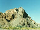
Unnamed hill in the lower part of Afton Canyon. | Photographed in November 1987, scanned from a slide in 2023.
Location records that use this photograph:
Article records that use this photograph:
images/1987-11-1-27-sm.jpg
| 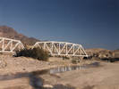
Union Pacific trestle over the Mojave River. | Photographed October 1987.
Location records that use this photograph:
Article records that use this photograph:
images/198711-1-24sm.jpg
| 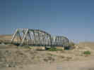
Union Pacific trestle over the Mojave River |
Article records that use this photograph:
images/1440-09.jpg
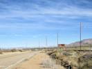
| Baker, California
| 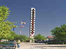
The World's Tallest Thermometer in Baker, CA. | Photograph taken in September, 1999.
Location records that use this photograph:
Article records that use this photograph:
images/2907-21.jpg
| 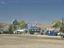
The Mad Greek Restaurant in Baker, California. | Photograph taken in September, 1999.
Location records that use this photograph:
Article records that use this photograph:
images/2907-22.jpg
| Barber Mountain
| 
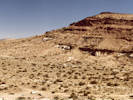
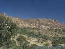
Hiking on Barker Mountain. | Photographed in April 1980, scanned from a slide in 2023.
Location records that use this photograph:
Article records that use this photograph:
images/1980-04-1-16-img331sm.jpg
| 
Lobo Point from the lower slopes of Barber Mountain | Photographed in April 1981, scanned from a slide in 2023.
Location records that use this photograph:
Article records that use this photograph:
images/1981-04-2-0-img324sm.jpg
| 
Descending Barber Mountain. | Photographed in April 1987, scanned from a slide in 2023.
Location records that use this photograph:
Article records that use this photograph:
images/1987-04-1-21-img333sm.jpg
| 
The north face of Barber Mountain as seen from Lobo Point. | Photographed in April 1980, scanned from a slide in 2023.
Location records that use this photograph:
Article records that use this photograph:
images/1980-04-2-37-img318sm.jpg
| 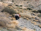
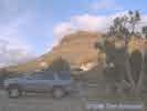
Lydia and Paul Schweich (my parents) climbing to the top of Barber Mountain. | Photographed November 1986.
Location records that use this photograph:
Article records that use this photograph:
images/198611-3-24sm.jpg
| 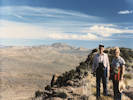
Lydia and Paul Schweich (my parents) on top of Barber Mountain. | Photographed November 1986.
Location records that use this photograph:
Article records that use this photograph:
images/198611-2-25sm.jpg
| 
Barber Mountain as seen from Granite Well. | Photographed in April 1981.
Location records that use this photograph:
Article records that use this photograph:
images/1981-04-4-8-img215sm.jpg
| 
View north northwest from Barber Mountain towards the Little Thorn Mountains and Granite Well. | Photographed April 1981. Lobo Point Road crosses at the bottom of the photograph.
Location records that use this photograph:
Article records that use this photograph:
images/8144-18-img203sm.jpg
| 
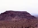
Sun setting on Barber Mountain. | This view looks east, and Hole in the Wall is on the other side of the mountain. This mountain is not formally named "Barber Mountain," but the Barber VABM is located on top. The climb to the top is about 300 meters and takes about an hour.
Location records that use this photograph:
Article records that use this photograph:
images/barber4runner.jpg
| 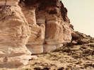
Cliff at base of Barber Mountain | Photographed April 1980, scanned from a print on 6 March 2018.
Location records that use this photograph:
Article records that use this photograph:
images/80043-7-300.jpg
| 
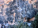
Ash bed used to correlate rock units on Barber Mountain | Photographed April 1980, scanned from a print on 6 March 2018.
Article records that use this photograph:
images/80043-9-300.jpg
| Barnwell
| 
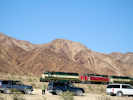
Barnwell | Photograph taken in June, 2000. Originally the headquarters of the Briggs and Murphy Ranch. Joined with other ranches into the Rock Springs Land and Cattle Company in 1894. The site of Barnwell was reached by the Nevada Southern Railway in 1893. At that time the site was named Manvel for the current president of the Santa Fe railroad. The railroad was reorganized as the California Eastern Railway in 1895, and the branch line to Searchlight built in 1906-1907. The name of this site was changed to Barnwell in 1907, named for a telegraph operator stationed there by the railroad company.
Location records that use this photograph:
Article records that use this photograph:
images/0072_3301_0700_31.jpg
| Basin
| 
Crossing the Union Pacific tracks at Basin. | Photographed 16 April 2017.
Location records that use this photograph:
Article records that use this photograph:
images/IMGQ3747sm.jpg
| Black Canyon Road
| 
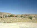
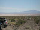
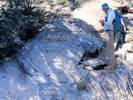
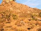
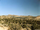
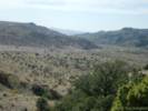
Black Canyon Road, looking north from near Gold Valley Ranch. | The low gray shrubs are Blackbrush (Coleogyne ramosissima>) and the large green shrubs are Utah Juniper (Juniperus osteosperma). This photograph was taken from a location about 50 meters north of the cows as seen in the photograph below. At first glance the vegetation might be classified as "pristine," as indeed much of the Mid Hills vegetation has been characterized. However, on closer examination there are many signs of usage by cattle, and it becomes impossible to know what the native vegetation might have been at this site.
Article records that use this photograph:
images/blacyn.jpg
| 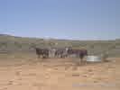
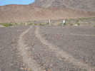
Cows along Black Canyon Road. |
Article records that use this photograph:
images/bcow.jpg
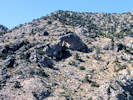
| Bonanza King Canyon
| 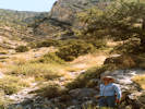
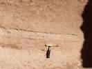
TAS in Bonanza King Canyon. | Photographed in April 1984.
Location records that use this photograph:
Article records that use this photograph:
images/1990-04-2-22-img254sm.jpg
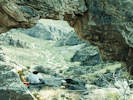
| 
View from the Mouth of the Canyon. | Photographed in April 1987. The arch is visible in the approximate center of the photo.
Location records that use this photograph:
Article records that use this photograph:
images/1987-04-5-8-img270sm.jpg
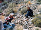
| 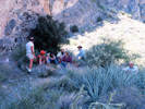
Eating lunch in the shade in Bonanza King Canyon. | Photographed in April 1985, scanned from a slide in 2023.
Location records that use this photograph:
Article records that use this photograph:
images/1985-04-4-36-img460sm.jpg
| 
Petroglyphs in Bonanza King Canyon. | Photographed in April 1985, scanned from a slide in 2023.
Location records that use this photograph:
Article records that use this photograph:
images/1985-04-5-06-img459sm.jpg
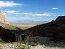
| 
Upper south branch of Bonanza King Canyon. | Photographed in April 1984.
Location records that use this photograph:
images/1984-04-img255sm.jpg
| 
Arch in Bonanza King Canyon. | Photographed in April 1985, scanned from a slide in 2023.
Location records that use this photograph:
Article records that use this photograph:
images/1985-04-5-04-img458sm.jpg
| 
Matt sitting in the arch of Bonanza King Canyon. | Photographed in April 1987, scanned from a slide in 2023.
Location records that use this photograph:
Article records that use this photograph:
images/1987-04-5-10-img457sm.jpg
| 
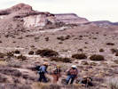
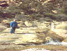
Linda and Julie looking for fossils in Bonanza King Canyon. | Photographed in April 1984, scanned from a slide in 2023.
Location records that use this photograph:
Article records that use this photograph:
images/1984-04-img456sm.jpg
| 
Linda and Julie with Bonanza King Canyon beyond. | Photographed in April 1984, scanned from a slide in 2023.
Location records that use this photograph:
Article records that use this photograph:
images/1984-04-img455sm.jpg
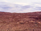
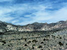
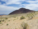
| Bristol Basin
| 
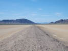
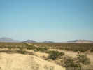
Bristol Basin from north slope | Photograph taken April 19. 2008. The "road" to this location ultimately ate eight tires on a field trip containing about 25 autos.
Location records that use this photograph:
Article records that use this photograph:
images/IMG10515sm.jpg
| 
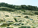
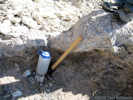
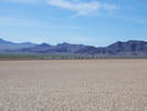
Desert pavement | Photograph taken April 19, 2008. The brownish outcrop in the middleground is tilted Peach Springs Tuff.
Article records that use this photograph:
images/IMG10516sm.jpg
| 
Bouse Formation near Amboy | Photograph taken April 19, 2008.
Article records that use this photograph:
images/IMG10517sm.jpg
| 
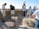
Examining the Bouse Formation | Photograph taken April 19, 2008.
Article records that use this photograph:
images/IMG10518sm.jpg
| 
Lawlor Tuff (Sonoma Volcanics) in the Bouse Formation | Photograph taken April 19, 2008.
Article records that use this photograph:
images/IMG10519sm.jpg
| 
Stromatolite at base of Bouse Formation | Photograph taken April 19, 2008.
Article records that use this photograph:
images/IMG10523sm.jpg
| Bristol Lake
| 
National Chloride Company | Photograph taken April 22, 2008.
Location records that use this photograph:
Article records that use this photograph: images/IMG10613sm.jpg
| 
Salt Plant on Bristol Lake | Photograph taken April 22, 2008.
Location records that use this photograph:
Article records that use this photograph:
images/IMG10612sm.jpg
| Broadwell Lake
| 
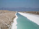
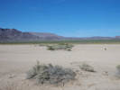
Tonopah and Tidewater roadbed north on Broadwell Lake | Photographed 16 April 2017.
Location records that use this photograph:
Article records that use this photograph:
images/IMGQ3771sm.jpg
| 
Field Trip Stop 2017-1-5. | Photographed 16 April 2017.
Location records that use this photograph:
Article records that use this photograph:
images/IMGQ3767sm.jpg
| 
Field Trip Stop 2017-1-5. | Photographed 16 April 2017.
Location records that use this photograph:
Article records that use this photograph:
images/IMGQ3763sm.jpg
| 
Vegetation in Broadwell Lake fissures. | Photographed 16 April 2017.
Location records that use this photograph:
Article records that use this photograph:
images/IMGQ3766sm.jpg
| Bullock Spring
| 
Bullock Spring as Seen from Chicken Water Spring. | Photographed in April 1995, scanned from a slide in 2023. Bullock spring is at the straight line of vegetation in the middle distance.
Location records that use this photograph:
Article records that use this photograph:
images/1996-04-Cody_bullock_spr_img285sm.jpg
| Cadiz Valley
| 
View southeast along Cadiz Road | Photograph taken April 19, 2008.
Location records that use this photograph:
Article records that use this photograph:
images/IMG10526sm.jpg
| 
Arizona and California Railroad | Photograph taken April 19, 2008.
Location records that use this photograph:
Article records that use this photograph:
images/IMG10530sm.jpg
| 
Cadiz Dunes | Photograph taken April 19, 2008.
Location records that use this photograph:
Article records that use this photograph:
images/IMG10525sm.jpg
| 
Field Trip Stop, Groundwater Discharge | Photograph taken April 19, 2008.
Article records that use this photograph:
images/IMG10527sm.jpg
| Camp Rock Spring
| 
Watson Wash at Camp Rock Spring. | Photographed April 1981, scanned from a print on 11 March 2018.
Location records that use this photograph:
Article records that use this photograph:
images/8143-13-320.jpg
| Caruthers Canyon
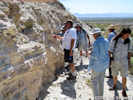
| 
Roy getting ready to photograph a fractured quartz dike in Caruthers Canyon. | Photographed in April 1985, scanned from a slide in 2023.
Location records that use this photograph:
Article records that use this photograph:
images/1985-04-5-18-img300sm.jpg
| 
View south out of Caruthers Canyon. | Photographed in April 1985, scanned from a slide in 2023.
Location records that use this photograph:
Article records that use this photograph:
images/1985-04-5-13-img306sm.jpg
| 
Mouth of Caruthers Canyon (1981). | Photographed in April 1981, scanned from a slide in 2023.
Location records that use this photograph:
Article records that use this photograph:
images/1981-04-3-27-img481sm.jpg
| 
Mouth of Caruthers Canyon. | Photographed in April 1985 from a little limestone hill in the mouth of the canyon.
Location records that use this photograph:
Article records that use this photograph:
images/1985-04-2-33-img249sm.jpg
| 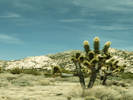
Joshua tree (Yucca brevifolia) in Caruthers Canyon. | Photographed in April 1987, scanned from a slide in 2023.
Location records that use this photograph:
Article records that use this photograph:
images/1987-04-5-1-img282sm.jpg
| 
Caruthers Canyon as seen from New York Mountain Road. | Caruthers Canyon is underlain by limestone intruded by granite. Granite can be seen intruding the small hill in right foreground.
Location records that use this photograph:
Article records that use this photograph:
images/3182-61.jpg
| 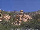
Unusual rock formation in Caruthers Canyon. | This often photographed rock formation in Caruthers Canyon, was also photographed by Annie Alexander and placed in her notebook with the notation of Fourth of July Canyon. It tells me that Annie was actually in Caruthers Canyon during her visit of 1940, and not in Fourth of July Canyon as her notebook states.
Article records that use this photograph:
images/3182-63.jpg
| 
Caruthers Canyon in June, 2000. | This photograph was taken from a location near where Annie or Louise took their photograph on page 44a. By GPS, the location is 11S 0654416 3899242.
Article records that use this photograph:
images/0072_3301_0700_17.jpg
| 
Caruthers Canyon (1987). | My dad in Caruthers Canyon, below the Giant Ledge Mine, after a November rainstorm.
Location records that use this photograph:
Article records that use this photograph:
images/dadcaruthers.jpg
| 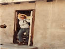
My house is your house | Photographed April 1981, scanned from a print 6 February 2018.
Location records that use this photograph:
Article records that use this photograph:
images/8143-25-300.jpg
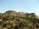
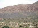
| Castle Peaks, Castle Mountains, etc.
| 
Castle Mountains Mine as seen from Ivanpah Road | Photograph taken April 22, 2004.
Location records that use this photograph:
Article records that use this photograph:
images/IMGP0429sm.jpg
| Cave Mountain
| 
Cave Mountain as seen from Field Trip Stop 2017-2-2. | Photographed 17 April 2017.
Location records that use this photograph:
Article records that use this photograph:
images/IMGQ3786sm.jpg
| 
Field Trip Stop 2017-2-2. Cave Mountain Fault. | Photographed 17 April 2017.
Location records that use this photograph:
Article records that use this photograph:
images/IMGQ3783sm.jpg
| Cedar Canyon
| 
Pinto Mountain to the east of the plateau. | Photographed November, 1990. Scanned 29 November 2020.
Article records that use this photograph:
images/90B2-24_X1200sm.jpg
| 
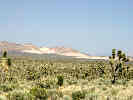
Joshua trees and Mojave Yuccas along Cedar Canyon Road. | Photographed in April 1995, scanned from a slide in 2023.
Location records that use this photograph:
Article records that use this photograph:
images/1995-04-img470sm.jpg
| 
Plateau north of Cedar Canyon. | Photographed November, 1990. Scanned 29 November 2020.
Article records that use this photograph:
images/90B2-15_X1200sm.jpg
| 
Cheryl at the top of a cascade we used to access the plateau. | Photographed November, 1990. Scanned 29 November 2020.
Article records that use this photograph:
images/90B2-22_X1200sm.jpg
| 
Vegetation along Cedar Canyon Road. | Photographed in April 1995, scanned from a slide in 2023.
Location records that use this photograph:
Article records that use this photograph:
images/1995-04-img278sm.jpg
| 
Patchy burned areas on Pinto Mountain. | Photograph taken October 15, 2005. In Cedar Canyon, we stopped to look at the location of my plot on Pinto Mountain. Again we were surprised by the patchy distribution of burned areas.
Article records that use this photograph:
images/IMGP2017sm.jpg
| 
View of Cedar Canyon from Pinto Mountain | Photograph taken October 15, 2005. The Hackberry Conplex Fire, driven by south winds, came toward the camera, and turned east along the south face of Pinto Mountain.
Location records that use this photograph:
Article records that use this photograph:
images/IMGP2026sm.jpg
| 
Lower Cedar Canyon after the Hackberry Complex Fire. | Photograph taken October 16, 2005.
Location records that use this photograph:
Article records that use this photograph:
images/IMGP2035sm.jpg
| 
Cedar Canyon as seen from Pinto Mountain | The Cedar Canyon Fault comes through the canyon at left and passes to the right, north of Pinto Mountain.
Location records that use this photograph:
Article records that use this photograph:
images/3201-75.jpg
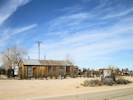
| Cima
| 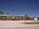
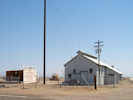
The Cima Store in Cima. |
Location records that use this photograph:
Article records that use this photograph:
images/3201-36.jpg
| 
Road Junction in Cima | Photographed 22 January 2015.
Location records that use this photograph:
Article records that use this photograph:
images/IMG40824sm.jpg
| 
Cima Store | Photographed 22 January 2015.
Location records that use this photograph:
Article records that use this photograph:
images/IMG40823sm.jpg
| Cima Dome
| 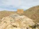
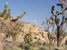
The Cross on Kessler Springs Road -- Covered this time. | Photograph taken April 21, 2004. When I passed by the cross on April 21, 2004, it was covered by the cardboard box, as shown. Someone has scrawled markings that look faintly religious on the box. Despite news reports that the cross is covered by a heavy tarp, it has been several years since I have seen the tarp. I passed by the cross again on Sunday, May 22, 2004. This time there was no covering for the cross. Meanwhile, the Ninth Circuit Court of Appeals, released a ruling on June 8, 2004, that the cross violated the Establishment clause. In the Department of Defense Appropriations Act of 2004, Rep. Jerry Lewis (R- San Bernardino) was able to insert a clause requiring the Department of Interior to transfer the property to private owners. The court, however, said that the transfer may take several years, and therefore the case is not moot. All this caused by a single retired Park Service employee, who in fact claims to be religious.
Article records that use this photograph:
images/IMGP0392sm.jpg
| 
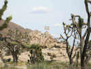
Blackbrush in pass between Cima Dome and Kessler Peak | Photograph taken June 1, 2009
Article records that use this photograph:
images/IMG01801sm.jpg
| 
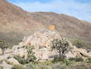
Cross beside Kessler Springs Road on Cima Dome. | Apparently this cross has caused some controversy about whether it is an appropriate icon in a national park, and there has been some discussion about removing it.
Article records that use this photograph:
images/0022_3291_2725_07.jpg
| 
The Cross-In-A-Box in May, 2008 | Photograph taken May 27, 2008.
Article records that use this photograph:
images/IMG_0664sm.jpg
| 
The Cross-In-A-Box on June 1, 2009 | Photograph taken June 1, 2009
Article records that use this photograph:
images/IMG01800sm.jpg
| 
Sunrise Rock, sans Cross, June 2012 | Photographed 27 May 2012.
Article records that use this photograph:
images/IMG30159sm.jpg
| Cima Volcanic Field
| 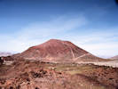
Cinder cone in Cima Volcanic Field. | Photographed in April 1982, scanned from a slide in 2023.
Location records that use this photograph:
Article records that use this photograph:
images/1982-04-1-3-img478sm.jpg
| 
Matt and Kate in Cima Volcanic Field, Cone No. 22. | Photographed in April 1982, scanned from a slide in 2023.
Location records that use this photograph:
Article records that use this photograph:
images/1982-04-1-2-img473sm.jpg
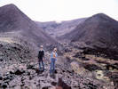
| 
Steve Wells explains about soils development on the flanks of basaltic cinder cones. | Protographed April 1990, scanned from a print 6 February 2018. This would be a field trip stop in the 1990 Mojave Desert Quaternary Research Symposium.
Location records that use this photograph:
Article records that use this photograph:
images/9051-27-300.jpg
| | |||||||||||||||||||||